Bridge Statistics for Reynolds, Georgia (GA)
Condition, Traffic, Stress, Structural Evaluation, Project Costs
- National Bridge Inventory (NBI) Statistics
- 17Number of bridges
- 433ft / 132mTotal length
- $43,139,000Total costs
- 51,828Total average daily traffic
- 940Total average daily truck traffic
- 77,667Total future (year 2031) average daily traffic
- National Bridge Inventory (NBI) Registered Bridges for Reynolds
- No street view available for this location
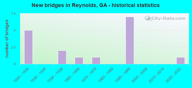
- New bridges - historical statistics
- 51930-1939
- 21950-1959
- 11960-1969
- 11970-1979
- 71990-1999
- 12020-2022


- Bridge Condition - Deck
- 8.3%Very good
- 75.0%Good
- 16.7%Satisfactory

- Bridge Condition - Superstructure
- 8.3%Very good
- 83.3%Good
- 8.3%Satisfactory

- Bridge Condition - Substructure
- 8.3%Very good
- 75.0%Good
- 8.3%Poor
- 8.3%Critical

- Bridge Condition - Channel
- 5.9%Excellent
- 58.8%Very good
- 11.8%Good
- 11.8%Satisfactory
- 11.8%Fair
Find on map >> Show street view
Structure Number: 1935066, Location: 9 MI W OF MARSHALLVILLE (Lat: 32.478628, Lng: -84.099869), Route carried "on" structure: County highway 2052, Year Built: 2020, Status: Open, Structure Length: 4.27m (14.01ft), Average Daily Traffic: 200 (year 2018), Truck Traffic: 1%, Average Future Daily Traffic: 225 (year 2041), Design Load: HL 93, Features Intersected: HORSE CREEK, Facility Carried by Structure: BUTLER MILL ROAD
Minimum Vertical Clearance: 30+ m (98+ ft), Kilometerpoint: 14.484, Lanes on structure: 2, Owner: County Highway Agency, Approaching Roadway Width: 6.4m (21.0ft), Material/Design: Concrete, Design/Construction: Box Beam or Girders - Multiple, Number Of Spans In Main Unit: 3, Length of Maximum Span: 16.8m (55.1ft), Curb or Sidewalk Widths: Left: 0.6m (2.0ft), Right: 0.6m (2.0ft), Curb-To-Curb Width: 9.1m (29.9ft), Out-to-Out Width: 10.1m (33.1ft)
Condition: Deck: Very good, Superstructure: Very good, Substructure: Very good, Channel: Excellent, Operating Rating: 71.6 metric tons, Method Used To Determine Operating Rating: Load Factor (LF), Inventory Rating: 42.6 metric tons, Method Used To Determine Inventory Rating: Load Factor (LF), Structural Evaluation: Equal to present desirable criteria, Deck Geometry: Equal to present minimum criteria, Waterway Adequacy: Equal to present desirable criteria, Approach Roadway Alignment: Equal to present desirable criteria, Length Of Structure Improvement: 5.12m (16.80ft), Designated Inspection Frequency: Every 24 months, Inspection Date: December 2020, Bridge Improvement Cost: $12,432,000, Roadway Improvement Cost: $1,243,000, Total Project Cost: $18,648,000 ( Estimate for 2020), Deck Structure Type: Concrete Cast-file-Place, Wearing Surface/Protective System: Wearing Surface: Bituminous
Find on map >> Show street view
Structure Number: 269001, Location: 13 MI NW OF BUTLER (Lat: 32.718328, Lng: -84.252467), Route carried "on" structure: US 80, Year Built: 1932, Status: Open, Structure Length: 0.88m (2.89ft), Average Daily Traffic: 740 (year 2011), Truck Traffic: 23%, Average Future Daily Traffic: 1,110 (year 2031), Design Load: H 15, Features Intersected: DUCK CREEK
Minimum Vertical Clearance: 30+ m (98+ ft), Kilometerpoint: 8.047, Lanes on structure: 2, Base Highway Network: Yes, Owner: State Highway Agency, Approaching Roadway Width: 8.5m (27.9ft), Material/Design: Concrete, Design/Construction: Culvert, Number Of Spans In Main Unit: 3, Length of Maximum Span: 2.7m (8.9ft)
Condition: Channel: Fair, Culverts: Good, Operating Rating: 46.2 metric tons, Method Used To Determine Operating Rating: Load Factor (LF), Inventory Rating: 28.1 metric tons, Method Used To Determine Inventory Rating: Load Factor (LF), Structural Evaluation: Better than present minimum criteria, Waterway Adequacy: Equal to present desirable criteria, Approach Roadway Alignment: Equal to present desirable criteria, Designated Inspection Frequency: Every 24 months, Inspection Date: May 2020, Bridge Improvement Cost: $113,000, Roadway Improvement Cost: $11,000, Total Project Cost: $170,000
Find on map >> Show street view
Structure Number: 2690016, Location: 1 MI S OF REYNOLDS (Lat: 32.542350, Lng: -84.101011), Route carried "on" structure: State highway 128, Year Built: 1938, Status: Open, Structure Length: 0.98m (3.22ft), Average Daily Traffic: 1,790 (year 2011), Truck Traffic: 16%, Average Future Daily Traffic: 2,685 (year 2031), Design Load: H 15, Features Intersected: LITTLE VINE CREEK
Minimum Vertical Clearance: 30+ m (98+ ft), Kilometerpoint: 3.219, Lanes on structure: 2, Base Highway Network: Yes, Owner: State Highway Agency, Approaching Roadway Width: 7.6m (24.9ft), Material/Design: Concrete, Design/Construction: Culvert, Number Of Spans In Main Unit: 3, Length of Maximum Span: 3.0m (9.8ft)
Condition: Channel: Satisfactory, Culverts: Good, Operating Rating: 54.4 metric tons, Method Used To Determine Operating Rating: Load Factor (LF), Inventory Rating: 32.6 metric tons, Method Used To Determine Inventory Rating: Load Factor (LF), Structural Evaluation: Better than present minimum criteria, Waterway Adequacy: Equal to present desirable criteria, Approach Roadway Alignment: Equal to present desirable criteria, Length Of Structure Improvement: 7.41m (24.31ft), Designated Inspection Frequency: Every 24 months, Underwater Inspection Frequency: Every 60 months, Inspection Date: May 2020, Underwater Inspection Date: April 2018, Bridge Improvement Cost: $125,000, Roadway Improvement Cost: $13,000, Total Project Cost: $188,000
Find on map >> Show street view
Structure Number: 2690017, Location: S EDGE OF REYNOLDS (Lat: 32.551478, Lng: -84.097769), Route carried "on" structure: State highway 128, Year Built: 1938, Status: Open, Structure Length: 1.16m (3.81ft), Average Daily Traffic: 2,490 (year 2011), Truck Traffic: 1%, Average Future Daily Traffic: 3,735 (year 2031), Design Load: H 15, Features Intersected: BEAVER CREEK
Minimum Vertical Clearance: 30+ m (98+ ft), Kilometerpoint: 4.828, Lanes on structure: 2, Base Highway Network: Yes, Owner: State Highway Agency, Approaching Roadway Width: 7.6m (24.9ft), Skew: 4 degrees, Material/Design: Concrete, Design/Construction: Culvert, Number Of Spans In Main Unit: 3, Length of Maximum Span: 3.7m (12.1ft)
Condition: Channel: Very good, Culverts: Good, Operating Rating: 41.7 metric tons, Method Used To Determine Operating Rating: Load Factor (LF), Inventory Rating: 24.4 metric tons, Method Used To Determine Inventory Rating: Load Factor (LF), Structural Evaluation: Equal to present minimum criteria, Waterway Adequacy: Equal to present desirable criteria, Approach Roadway Alignment: Equal to present desirable criteria, Length Of Structure Improvement: 7.56m (24.80ft), Designated Inspection Frequency: Every 24 months, Inspection Date: May 2020, Bridge Improvement Cost: $148,000, Roadway Improvement Cost: $15,000, Total Project Cost: $223,000
Find on map >> Show street view
Structure Number: 2690018, Location: .5 MI N OF REYNOLDS (Lat: 32.572778, Lng: -84.091033), Route carried "on" structure: State highway 128, Year Built: 1937, Status: Open, Structure Length: 3.66m (12.01ft), Average Daily Traffic: 1,790 (year 2011), Truck Traffic: 1%, Average Future Daily Traffic: 2,685 (year 2031), Design Load: H 15, Features Intersected: PATSILIGA CREEK O/F
Minimum Vertical Clearance: 30+ m (98+ ft), Kilometerpoint: 6.437, Lanes on structure: 2, Base Highway Network: Yes, Owner: State Highway Agency, Approaching Roadway Width: 7.3m (24.0ft), Material/Design: Concrete, Design/Construction: Tee Beam, Number Of Spans In Main Unit: 4, Length of Maximum Span: 9.1m (29.9ft), Curb or Sidewalk Widths: Left: 0.2m (0.7ft), Right: 0.2m (0.7ft), Curb-To-Curb Width: 7.3m (24.0ft), Out-to-Out Width: 7.6m (24.9ft)
Condition: Deck: Good, Superstructure: Good, Substructure: Good, Channel: Very good, Operating Rating: 38.1 metric tons, Method Used To Determine Operating Rating: Allowable Stress (AS), Inventory Rating: 21.7 metric tons, Method Used To Determine Inventory Rating: Allowable Stress (AS), Structural Evaluation: Somewhat better than minimum adequacy, Deck Geometry: Meets minimum limits, Waterway Adequacy: Equal to present desirable criteria, Approach Roadway Alignment: Equal to present desirable criteria, Length Of Structure Improvement: 10.09m (33.10ft), Designated Inspection Frequency: Every 24 months, Underwater Inspection Frequency: Every 60 months, Inspection Date: June 2020, Underwater Inspection Date: April 2018, Bridge Improvement Cost: $469,000, Roadway Improvement Cost: $47,000, Total Project Cost: $703,000, Deck Structure Type: Concrete Cast-file-Place, Wearing Surface/Protective System: Wearing Surface: Bituminous
Find on map >> Show street view
Structure Number: 2690019, Location: .7 MI N OF REYNOLDS (Lat: 32.573947, Lng: -84.090386), Route carried "on" structure: State highway 128, Year Built: 1937, Status: Open, Structure Length: 5.49m (18.01ft), Average Daily Traffic: 1,790 (year 2011), Truck Traffic: 1%, Average Future Daily Traffic: 2,685 (year 2031), Design Load: H 15, Features Intersected: PATSILIGA CREEK
Minimum Vertical Clearance: 30+ m (98+ ft), Kilometerpoint: 6.437, Lanes on structure: 2, Base Highway Network: Yes, Owner: State Highway Agency, Approaching Roadway Width: 7.3m (24.0ft), Material/Design: Concrete, Design/Construction: Tee Beam, Number Of Spans In Main Unit: 6, Length of Maximum Span: 9.1m (29.9ft), Curb or Sidewalk Widths: Left: 0.2m (0.7ft), Right: 0.2m (0.7ft), Curb-To-Curb Width: 7.3m (24.0ft), Out-to-Out Width: 7.6m (24.9ft)
Condition: Deck: Good, Superstructure: Good, Substructure: Poor, Channel: Satisfactory, Operating Rating: 46.2 metric tons, Method Used To Determine Operating Rating: Load Factor (LF), Inventory Rating: 28.1 metric tons, Method Used To Determine Inventory Rating: Load Factor (LF), Structural Evaluation: Meets minimum limits, Deck Geometry: Meets minimum limits, Waterway Adequacy: Equal to present desirable criteria, Approach Roadway Alignment: Equal to present minimum criteria, Length Of Structure Improvement: 45.72m (150.00ft), Designated Inspection Frequency: Every 24 months, Underwater Inspection Frequency: Every 24 months, Inspection Date: June 2020, Underwater Inspection Date: April 2020, Bridge Improvement Cost: $703,000, Roadway Improvement Cost: $70,000, Total Project Cost: $1,055,000, Deck Structure Type: Concrete Cast-file-Place, Wearing Surface/Protective System: Wearing Surface: Bituminous
Find on map >> Show street view
Structure Number: 2690032, Location: 4 MI SE OF REYNOLDS (Lat: 32.522839, Lng: -84.053347), Route carried "on" structure: County highway 269, Year Built: 1975, Status: Open, Structure Length: 1.52m (4.99ft), Average Daily Traffic: 180 (year 2011), Truck Traffic: 1%, Average Future Daily Traffic: 270 (year 2031), Design Load: H 15, Features Intersected: BEAVER CREEK, Facility Carried by Structure: JOHN B. GORDON RD
Minimum Vertical Clearance: 30+ m (98+ ft), Kilometerpoint: 0.000, Lanes on structure: 2, Base Highway Network: Yes, Owner: County Highway Agency, Approaching Roadway Width: 6.7m (22.0ft), Material/Design: Prestressed concrete, Design/Construction: Box Beam or Girders - Multiple, Number Of Spans In Main Unit: 2, Length of Maximum Span: 7.6m (24.9ft), Curb-To-Curb Width: 8.3m (27.2ft), Out-to-Out Width: 9.8m (32.2ft)
Condition: Deck: Good, Superstructure: Good, Substructure: Good, Channel: Very good, Operating Rating: 36.2 metric tons, Method Used To Determine Operating Rating: Load Factor (LF), Inventory Rating: 21.7 metric tons, Method Used To Determine Inventory Rating: Load Factor (LF), Structural Evaluation: Equal to present minimum criteria, Deck Geometry: Somewhat better than minimum adequacy, Waterway Adequacy: Equal to present desirable criteria, Approach Roadway Alignment: Equal to present minimum criteria, Designated Inspection Frequency: Every 24 months, Underwater Inspection Frequency: Every 60 months, Inspection Date: May 2020, Underwater Inspection Date: April 2018, Bridge Improvement Cost: $195,000, Roadway Improvement Cost: $20,000, Total Project Cost: $293,000, Deck Structure Type: Concrete Precast Panels, Wearing Surface/Protective System: Wearing Surface: Bituminous
Find on map >> Show street view
Structure Number: 2690035, Location: 3 MI E OF REYNOLDS (Lat: 32.550083, Lng: -84.047319), Route carried "on" structure: State highway 96, Year Built: 1993, Status: Open, Structure Length: 12.19m (39.99ft), Average Daily Traffic: 6,970 (year 2011), Truck Traffic: 1%, Average Future Daily Traffic: 10,455 (year 2031), Design Load: HS 20+Mod, Features Intersected: BEECHWOOD SWAMP
Minimum Vertical Clearance: 30+ m (98+ ft), Kilometerpoint: 35.406, Lanes on structure: 2, Base Highway Network: Yes, Owner: State Highway Agency, Approaching Roadway Width: 9.1m (29.9ft), Skew: 14 degrees, Material/Design: Concrete, Design/Construction: Tee Beam, Number Of Spans In Main Unit: 10, Length of Maximum Span: 12.2m (40.0ft), Curb-To-Curb Width: 11.6m (38.1ft), Out-to-Out Width: 12.6m (41.3ft)
Condition: Deck: Good, Superstructure: Good, Substructure: Good, Channel: Very good, Operating Rating: 67.1 metric tons, Method Used To Determine Operating Rating: Load Factor (LF), Inventory Rating: 40.8 metric tons, Method Used To Determine Inventory Rating: Load Factor (LF), Structural Evaluation: Better than present minimum criteria, Deck Geometry: Better than present minimum criteria, Waterway Adequacy: Equal to present desirable criteria, Approach Roadway Alignment: Equal to present desirable criteria, Designated Inspection Frequency: Every 24 months, Inspection Date: May 2020, Bridge Improvement Cost: $1,563,000, Roadway Improvement Cost: $156,000, Total Project Cost: $2,344,000, Deck Structure Type: Concrete Cast-file-Place
Find on map >> Show street view
Structure Number: 2690036, Location: 3.4 MI E OF REYNOLDS (Lat: 32.546928, Lng: -84.040097), Route carried "on" structure: State highway 96, Year Built: 1993, Status: Open, Structure Length: 18.29m (60.01ft), Average Daily Traffic: 6,970 (year 2011), Truck Traffic: 1%, Average Future Daily Traffic: 10,455 (year 2031), Design Load: HS 20+Mod, Features Intersected: BEECHWOOD SWAMP
Minimum Vertical Clearance: 30+ m (98+ ft), Kilometerpoint: 37.015, Lanes on structure: 2, Base Highway Network: Yes, Owner: State Highway Agency, Approaching Roadway Width: 8.5m (27.9ft), Skew: 14 degrees, Material/Design: Concrete, Design/Construction: Tee Beam, Number Of Spans In Main Unit: 15, Length of Maximum Span: 12.2m (40.0ft), Curb-To-Curb Width: 11.6m (38.1ft), Out-to-Out Width: 12.6m (41.3ft)
Condition: Deck: Good, Superstructure: Good, Substructure: Good, Channel: Very good, Operating Rating: 35.3 metric tons, Method Used To Determine Operating Rating: Load Factor (LF), Inventory Rating: 27.2 metric tons, Method Used To Determine Inventory Rating: Load Factor (LF), Structural Evaluation: Equal to present minimum criteria, Deck Geometry: Better than present minimum criteria, Waterway Adequacy: Equal to present desirable criteria, Approach Roadway Alignment: Equal to present desirable criteria, Designated Inspection Frequency: Every 24 months, Inspection Date: May 2020, Bridge Improvement Cost: $2,344,000, Roadway Improvement Cost: $234,000, Total Project Cost: $3,516,000, Deck Structure Type: Concrete Cast-file-Place
Find on map >> Show street view
Structure Number: 2690037, Location: 4 MI E OF REYNOLDS (Lat: 32.542939, Lng: -84.030889), Route carried "on" structure: State highway 96, Year Built: 1993, Status: Open, Structure Length: 18.29m (60.01ft), Average Daily Traffic: 6,970 (year 2011), Truck Traffic: 1%, Average Future Daily Traffic: 10,455 (year 2031), Design Load: HS 20+Mod, Features Intersected: BEECHWOOD SWAMP
Minimum Vertical Clearance: 30+ m (98+ ft), Kilometerpoint: 37.015, Lanes on structure: 2, Base Highway Network: Yes, Owner: State Highway Agency, Approaching Roadway Width: 7.3m (24.0ft), Skew: 14 degrees, Material/Design: Concrete, Design/Construction: Tee Beam, Number Of Spans In Main Unit: 15, Length of Maximum Span: 12.2m (40.0ft), Curb-To-Curb Width: 11.6m (38.1ft), Out-to-Out Width: 12.6m (41.3ft)
Condition: Deck: Good, Superstructure: Good, Substructure: Good, Channel: Very good, Operating Rating: 67.1 metric tons, Method Used To Determine Operating Rating: Load Factor (LF), Inventory Rating: 40.8 metric tons, Method Used To Determine Inventory Rating: Load Factor (LF), Structural Evaluation: Better than present minimum criteria, Deck Geometry: Better than present minimum criteria, Waterway Adequacy: Equal to present desirable criteria, Approach Roadway Alignment: Equal to present desirable criteria, Designated Inspection Frequency: Every 24 months, Inspection Date: May 2020, Bridge Improvement Cost: $2,344,000, Roadway Improvement Cost: $234,000, Total Project Cost: $3,516,000, Deck Structure Type: Concrete Cast-file-Place
Find on map >> Show street view
Structure Number: 2690039, Location: 3 MI E OF REYNOLDS (Lat: 32.550306, Lng: -84.047356), Route carried "on" structure: State highway 96, Year Built: 1996, Status: Open, Structure Length: 12.19m (39.99ft), Average Daily Traffic: 6,970 (year 2011), Truck Traffic: 1%, Average Future Daily Traffic: 10,455 (year 2031), Design Load: HS 20+Mod, Features Intersected: BEECHWOOD SWAMP
Minimum Vertical Clearance: 30+ m (98+ ft), Kilometerpoint: 35.406, Lanes on structure: 2, Base Highway Network: Yes, Owner: State Highway Agency, Approaching Roadway Width: 9.1m (29.9ft), Skew: 14 degrees, Material/Design: Concrete, Design/Construction: Tee Beam, Number Of Spans In Main Unit: 10, Length of Maximum Span: 12.2m (40.0ft), Curb-To-Curb Width: 11.6m (38.1ft), Out-to-Out Width: 12.6m (41.3ft)
Condition: Deck: Good, Superstructure: Good, Substructure: Good, Channel: Very good, Operating Rating: 43.5 metric tons, Method Used To Determine Operating Rating: Load Factor (LF), Inventory Rating: 26.3 metric tons, Method Used To Determine Inventory Rating: Load Factor (LF), Structural Evaluation: Equal to present minimum criteria, Deck Geometry: Better than present minimum criteria, Waterway Adequacy: Equal to present desirable criteria, Approach Roadway Alignment: Equal to present desirable criteria, Designated Inspection Frequency: Every 24 months, Inspection Date: May 2020, Bridge Improvement Cost: $1,563,000, Roadway Improvement Cost: $156,000, Total Project Cost: $2,344,000, Deck Structure Type: Concrete Cast-file-Place
Find on map >> Show street view
Structure Number: 269004, Location: 3 MI E OF REYNOLDS (Lat: 32.547150, Lng: -84.040097), Route carried "on" structure: State highway 96, Year Built: 1996, Status: Open, Structure Length: 18.29m (60.01ft), Average Daily Traffic: 6,970 (year 2011), Truck Traffic: 1%, Average Future Daily Traffic: 10,455 (year 2031), Design Load: HS 20+Mod, Features Intersected: BEECHWOOD SWAMP
Minimum Vertical Clearance: 30+ m (98+ ft), Kilometerpoint: 37.015, Lanes on structure: 2, Base Highway Network: Yes, Owner: State Highway Agency, Approaching Roadway Width: 9.1m (29.9ft), Skew: 14 degrees, Material/Design: Concrete, Design/Construction: Tee Beam, Number Of Spans In Main Unit: 15, Length of Maximum Span: 12.2m (40.0ft), Curb-To-Curb Width: 11.6m (38.1ft), Out-to-Out Width: 12.6m (41.3ft)
Condition: Deck: Good, Superstructure: Good, Substructure: Good, Channel: Very good, Operating Rating: 58.9 metric tons, Method Used To Determine Operating Rating: Load Factor (LF), Inventory Rating: 35.3 metric tons, Method Used To Determine Inventory Rating: Load Factor (LF), Structural Evaluation: Better than present minimum criteria, Deck Geometry: Better than present minimum criteria, Waterway Adequacy: Equal to present desirable criteria, Approach Roadway Alignment: Equal to present desirable criteria, Designated Inspection Frequency: Every 24 months, Inspection Date: May 2020, Bridge Improvement Cost: $2,344,000, Roadway Improvement Cost: $234,000, Total Project Cost: $3,516,000, Deck Structure Type: Concrete Cast-file-Place
Find on map >> Show street view
Structure Number: 2690041, Location: 3.1 MI E OF REYNOLDS (Lat: 32.543189, Lng: -84.030942), Route carried "on" structure: State highway 96, Year Built: 1996, Status: Open, Structure Length: 18.29m (60.01ft), Average Daily Traffic: 6,970 (year 2011), Truck Traffic: 1%, Average Future Daily Traffic: 10,455 (year 2031), Design Load: HS 20+Mod, Features Intersected: BEECHWOOD SWAMP
Minimum Vertical Clearance: 30+ m (98+ ft), Kilometerpoint: 37.015, Lanes on structure: 2, Base Highway Network: Yes, Owner: State Highway Agency, Approaching Roadway Width: 9.1m (29.9ft), Skew: 14 degrees, Material/Design: Concrete, Design/Construction: Tee Beam, Number Of Spans In Main Unit: 15, Length of Maximum Span: 12.2m (40.0ft), Curb-To-Curb Width: 11.6m (38.1ft), Out-to-Out Width: 12.6m (41.3ft)
Condition: Deck: Good, Superstructure: Good, Substructure: Good, Channel: Very good, Operating Rating: 59.8 metric tons, Method Used To Determine Operating Rating: Load Factor (LF), Inventory Rating: 35.3 metric tons, Method Used To Determine Inventory Rating: Load Factor (LF), Structural Evaluation: Better than present minimum criteria, Deck Geometry: Better than present minimum criteria, Waterway Adequacy: Equal to present desirable criteria, Approach Roadway Alignment: Equal to present desirable criteria, Designated Inspection Frequency: Every 24 months, Inspection Date: May 2020, Bridge Improvement Cost: $2,344,000, Roadway Improvement Cost: $234,000, Total Project Cost: $3,516,000, Deck Structure Type: Concrete Cast-file-Place
Find on map >> Show street view
Structure Number: 2695018, Location: 3 MI NW OF REYNOLDS (Lat: 32.591358, Lng: -84.130458), Route carried "on" structure: County highway 126, Year Built: 1950, Year Reconstructed: 1989, Status: Posted for load, Structure Length: 1.04m (3.41ft), Average Daily Traffic: 104 (year 2011), Truck Traffic: 1%, Average Future Daily Traffic: 156 (year 2031), Features Intersected: PATSILIGA CREEK TRIB
Minimum Vertical Clearance: 30+ m (98+ ft), Kilometerpoint: 4.828, Lanes on structure: 2, Base Highway Network: Yes, Owner: County Highway Agency, Approaching Roadway Width: 6.1m (20.0ft), Material/Design: Steel continuous, Design/Construction: Stringer/Multi-beam, Number Of Spans In Main Unit: 2, Length of Maximum Span: 5.8m (19.0ft), Curb-To-Curb Width: 7.2m (23.6ft), Out-to-Out Width: 7.5m (24.6ft)
Condition: Deck: Satisfactory, Superstructure: Satisfactory, Substructure: Good, Channel: Good, Operating Rating: 60.7 metric tons, Method Used To Determine Operating Rating: Load Factor (LF), Inventory Rating: 36.2 metric tons, Method Used To Determine Inventory Rating: Load Factor (LF), Structural Evaluation: Equal to present minimum criteria, Deck Geometry: Meets minimum limits, Waterway Adequacy: Better than present minimum criteria, Approach Roadway Alignment: Meets minimum limits, Length Of Structure Improvement: 41.36m (135.70ft), Designated Inspection Frequency: Every 24 months, Inspection Date: June 2020, Bridge Improvement Cost: $133,000, Roadway Improvement Cost: $13,000, Total Project Cost: $199,000, Deck Structure Type: Concrete Cast-file-Place
Find on map >> Show street view
Structure Number: 2695019, Location: 2 MI NW OF REYNOLDS (Lat: 32.591947, Lng: -84.125100), Route carried "on" structure: County highway 128, Year Built: 1960, Status: Posted for load, Structure Length: 6.83m (22.41ft), Average Daily Traffic: 104 (year 2011), Truck Traffic: 1%, Average Future Daily Traffic: 156 (year 2031), Design Load: H 15, Features Intersected: PATSILIGA CREEK, Facility Carried by Structure: TURNER ROAD
Minimum Vertical Clearance: 30+ m (98+ ft), Kilometerpoint: 0.000, Lanes on structure: 2, Base Highway Network: Yes, Owner: County Highway Agency, Approaching Roadway Width: 6.1m (20.0ft), Material/Design: Steel, Design/Construction: Stringer/Multi-beam, Number Of Spans In Main Unit: 14, Length of Maximum Span: 4.9m (16.1ft), Curb-To-Curb Width: 7.3m (24.0ft), Out-to-Out Width: 7.7m (25.3ft)
Condition: Deck: Satisfactory, Superstructure: Good, Substructure: Critical, Channel: Very good, Structural Evaluation: High priority of replacement, Deck Geometry: Somewhat better than minimum adequacy, Waterway Adequacy: Equal to present desirable criteria, Approach Roadway Alignment: Better than present minimum criteria, Bridge Posting: Required (Relationship of Operating Rating to Maximum Legal Load: > 39.9% below), Length Of Structure Improvement: 47.06m (154.40ft), Designated Inspection Frequency: Every 24 months, Underwater Inspection Frequency: Every 60 months, Inspection Date: May 2020, Underwater Inspection Date: April 2018, Other Special Inspection Date: January 2021, Bridge Improvement Cost: $875,000, Roadway Improvement Cost: $88,000, Total Project Cost: $1,313,000, Deck Structure Type: Concrete Cast-file-Place
Find on map >> Show street view
Structure Number: 2695023, Location: .5 MI SW OF REYNOLDS (Lat: 32.546900, Lng: -84.108692), Route carried "on" structure: County highway 251, Year Built: 1950, Status: Open, Structure Length: 0.98m (3.22ft), Average Daily Traffic: 280 (year 2011), Truck Traffic: 1%, Average Future Daily Traffic: 420 (year 2031), Design Load: H 15, Features Intersected: LITTLE VINE CREEK, Facility Carried by Structure: MILLER ROAD
Minimum Vertical Clearance: 30+ m (98+ ft), Kilometerpoint: 11.265, Lanes on structure: 2, Base Highway Network: Yes, Owner: County Highway Agency, Approaching Roadway Width: 6.1m (20.0ft), Material/Design: Concrete, Design/Construction: Culvert, Number Of Spans In Main Unit: 3, Length of Maximum Span: 3.0m (9.8ft)
Condition: Channel: Fair, Culverts: Good, Operating Rating: 41.7 metric tons, Method Used To Determine Operating Rating: Field evaluation and documented engineering judgment, Inventory Rating: 24.4 metric tons, Method Used To Determine Inventory Rating: Field evaluation and documented engineering judgment, Structural Evaluation: Equal to present minimum criteria, Waterway Adequacy: Equal to present desirable criteria, Approach Roadway Alignment: Equal to present minimum criteria, Designated Inspection Frequency: Every 24 months, Underwater Inspection Frequency: Every 60 months, Inspection Date: May 2020, Underwater Inspection Date: April 2018, Bridge Improvement Cost: $125,000, Roadway Improvement Cost: $13,000, Total Project Cost: $188,000
Find on map >> Show street view
Structure Number: 2695028, Location: IN POTTERSVILLE (Lat: 32.513983, Lng: -84.122450), Route carried "on" structure: County highway 1154, Year Built: 1998, Status: Open, Structure Length: 7.32m (24.02ft), Average Daily Traffic: 540 (year 2011), Truck Traffic: 1%, Average Future Daily Traffic: 810 (year 2031), Design Load: HS 20+Mod, Features Intersected: HORSE CREEK, Facility Carried by Structure: TOMMY PURVIS RD
Minimum Vertical Clearance: 30+ m (98+ ft), Kilometerpoint: 9.656, Lanes on structure: 2, Base Highway Network: Yes, Owner: County Highway Agency, Approaching Roadway Width: 6.7m (22.0ft), Material/Design: Concrete, Design/Construction: Culvert, Number Of Spans In Main Unit: 21, Length of Maximum Span: 1.8m (5.9ft)
Condition: Channel: Good, Culverts: Good, Operating Rating: 55.3 metric tons, Method Used To Determine Operating Rating: Field evaluation and documented engineering judgment, Inventory Rating: 32.6 metric tons, Method Used To Determine Inventory Rating: Field evaluation and documented engineering judgment, Structural Evaluation: Better than present minimum criteria, Waterway Adequacy: Equal to present desirable criteria, Approach Roadway Alignment: Better than present minimum criteria, Designated Inspection Frequency: Every 24 months, Underwater Inspection Frequency: Every 60 months, Inspection Date: May 2020, Underwater Inspection Date: April 2018, Bridge Improvement Cost: $938,000, Roadway Improvement Cost: $94,000, Total Project Cost: $1,407,000