Bridge Statistics for Rice, Texas (TX)
Condition, Traffic, Stress, Structural Evaluation, Project Costs
- National Bridge Inventory (NBI) Statistics
- 24Number of bridges
- 774ft / 236mTotal length
- 458,714Total average daily traffic
- 107,369Total average daily truck traffic
- National Bridge Inventory (NBI) Registered Bridges for Rice
- No street view available for this location
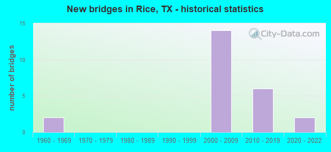
- New bridges - historical statistics
- 21960-1969
- 142000-2009
- 62010-2019
- 22020-2022


- Bridge Condition - Deck
- 6.3%Excellent
- 6.3%Very good
- 87.5%Good

- Bridge Condition - Superstructure
- 37.5%Very good
- 56.3%Good
- 6.3%Satisfactory

- Bridge Condition - Substructure
- 18.8%Very good
- 68.8%Good
- 12.5%Satisfactory

- Bridge Condition - Channel
- 25.0%Very good
- 50.0%Good
- 12.5%Satisfactory
- 12.5%Fair
Find on map >> Show street view
Structure Number: 180710009205355, Location: 5.5 MI SE OF FM 85 (Lat: 32.271314, Lng: -96.512850), Route carried "on" structure: State highway 1182, Year Built: 2000, Status: Open, Structure Length: 10.36m (33.99ft), Average Daily Traffic: 1,100 (year 2010), Truck Traffic: 15%, Average Future Daily Traffic: 2,180 (year 2028), Design Load: HS 20, Features Intersected: IH 45
Minimum Vertical Clearance: 30+ m (98+ ft), Kilometerpoint: 0.074, Lanes on structure: 2, Lanes under structure: 10, Owner: State Highway Agency, Approaching Roadway Width: 12.2m (40.0ft), Material/Design: Prestressed concrete, Design/Construction: Stringer/Multi-beam, Number Of Spans In Main Unit: 2, Number Of Approach Spans: 4, Length of Maximum Span: 21.3m (69.9ft), Curb-To-Curb Width: 11.9m (39.0ft), Out-to-Out Width: 12.8m (42.0ft)
Condition: Deck: Good, Superstructure: Good, Substructure: Good, Operating Rating: 54.4 metric tons, Method Used To Determine Operating Rating: Assigned rating based on Load Factor Design (LFD) reported in metric tons, Inventory Rating: 32.7 metric tons, Method Used To Determine Inventory Rating: Assigned rating based on Load Factor Design (LFD) reported in metric tons, Structural Evaluation: Better than present minimum criteria, Deck Geometry: Equal to present minimum criteria, Underclear: Somewhat better than minimum adequacy, Approach Roadway Alignment: Equal to present desirable criteria, Designated Inspection Frequency: Every 24 months, Inspection Date: November 2021, Deck Structure Type: Concrete Cast-file-Place
Find on map >> Show street view
Structure Number: 180710131702006, Location: 1.3 MI NE OF IH 45 (Lat: 32.286014, Lng: -96.495989), Route carried "on" structure: State highway 1182, Year Built: 1960, Status: Open, Structure Length: 2.74m (8.99ft), Average Daily Traffic: 661 (year 2020), Truck Traffic: 6%, Average Future Daily Traffic: 420 (year 2033), Design Load: H 15, Features Intersected: GRAYS CREEK
Minimum Vertical Clearance: 30+ m (98+ ft), Kilometerpoint: 2.309, Lanes on structure: 2, Owner: State Highway Agency, Approaching Roadway Width: 6.7m (22.0ft), Material/Design: Concrete, Design/Construction: Stringer/Multi-beam, Number Of Spans In Main Unit: 3, Length of Maximum Span: 9.1m (29.9ft), Curb-To-Curb Width: 7.0m (23.0ft), Out-to-Out Width: 7.5m (24.6ft)
Condition: Deck: Good, Superstructure: Satisfactory, Substructure: Satisfactory, Channel: Satisfactory, Operating Rating: 51.7 metric tons, Method Used To Determine Operating Rating: Load Factor (LF), Inventory Rating: 30.8 metric tons, Method Used To Determine Inventory Rating: Load Factor (LF), Structural Evaluation: Equal to present minimum criteria, Deck Geometry: Meets minimum limits, Waterway Adequacy: Better than present minimum criteria, Approach Roadway Alignment: High priority of corrective action, Length Of Structure Improvement: 2.74m (8.99ft), Designated Inspection Frequency: Every 24 months, Inspection Date: November 2021, Deck Structure Type: Concrete Cast-file-Place, Wearing Surface/Protective System: Wearing Surface: Bituminous
Find on map >> Show street view
Structure Number: 18175000920635, Location: 4.50 MI N OF SH 31 (Lat: 32.158003, Lng: -96.468758), Route carried "on" structure: Interstate 45, Year Built: 2000, Status: Open, Structure Length: 21.95m (72.01ft), Average Daily Traffic: 48,460 (year 2020), Truck Traffic: 21%, Average Future Daily Traffic: 62,410 (year 2033), Design Load: HS 20, Features Intersected: CHAMBERS CREEK RELIEF
Minimum Vertical Clearance: 30+ m (98+ ft), Kilometerpoint: 41.149, Lanes on structure: 6, Owner: State Highway Agency, Approaching Roadway Width: 34.1m (111.9ft), Skew: 30 degrees, Material/Design: Prestressed concrete, Design/Construction: Stringer/Multi-beam, Number Of Spans In Main Unit: 9, Length of Maximum Span: 24.4m (80.1ft), Curb-To-Curb Width: 33.8m (110.9ft), Out-to-Out Width: 35.4m (116.1ft)
Condition: Deck: Good, Superstructure: Good, Substructure: Good, Channel: Good, Operating Rating: 54.4 metric tons, Method Used To Determine Operating Rating: Assigned rating based on Load Factor Design (LFD) reported in metric tons, Inventory Rating: 32.7 metric tons, Method Used To Determine Inventory Rating: Assigned rating based on Load Factor Design (LFD) reported in metric tons, Structural Evaluation: Better than present minimum criteria, Deck Geometry: Superior to present desirable criteria, Waterway Adequacy: Superior to present desirable criteria, Approach Roadway Alignment: Equal to present desirable criteria, Designated Inspection Frequency: Every 24 months, Inspection Date: Febuary 2020, Deck Structure Type: Concrete Cast-file-Place
Find on map >> Show street view
Structure Number: 181750009206351, Location: 5.00 MI N OF SH 31 (Lat: 32.165994, Lng: -96.469742), Route carried "on" structure: Interstate 45, Year Built: 2000, Status: Open, Structure Length: 46.33m (152.00ft), Average Daily Traffic: 48,460 (year 2020), Truck Traffic: 21%, Average Future Daily Traffic: 62,410 (year 2033), Design Load: HS 20, Features Intersected: CHAMBERS CREEK
Minimum Vertical Clearance: 30+ m (98+ ft), Kilometerpoint: 41.767, Lanes on structure: 6, Owner: State Highway Agency, Approaching Roadway Width: 34.7m (113.8ft), Skew: 39 degrees, Material/Design: Prestressed concrete, Design/Construction: Stringer/Multi-beam, Number Of Spans In Main Unit: 3, Number Of Approach Spans: 15, Length of Maximum Span: 36.6m (120.1ft), Curb-To-Curb Width: 34.5m (113.2ft), Out-to-Out Width: 35.4m (116.1ft)
Condition: Deck: Good, Superstructure: Good, Substructure: Good, Channel: Good, Operating Rating: 54.4 metric tons, Method Used To Determine Operating Rating: Assigned rating based on Load Factor Design (LFD) reported in metric tons, Inventory Rating: 32.7 metric tons, Method Used To Determine Inventory Rating: Assigned rating based on Load Factor Design (LFD) reported in metric tons, Structural Evaluation: Better than present minimum criteria, Deck Geometry: Superior to present desirable criteria, Waterway Adequacy: Equal to present desirable criteria, Approach Roadway Alignment: Equal to present desirable criteria, Designated Inspection Frequency: Every 24 months, Inspection Date: January 2020, Deck Structure Type: Concrete Cast-file-Place
Find on map >> Show street view
Structure Number: 181750009206377, Location: 10.8 MI N OF SH 31 (Lat: 32.244428, Lng: -96.496367), Route carried "on" structure: County highway 244, Year Built: 2001, Status: Open, Structure Length: 8.84m (29.00ft), Average Daily Traffic: 1,008 (year 2019), Average Future Daily Traffic: 1,500 (year 2028), Design Load: HS 20, Features Intersected: IH 45, Facility Carried by Structure: CALHOUN STREET
Minimum Vertical Clearance: 30+ m (98+ ft), Kilometerpoint: 0.805, Lanes on structure: 2, Lanes under structure: 8, Owner: State Highway Agency, Approaching Roadway Width: 11.6m (38.1ft), Material/Design: Prestressed concrete, Design/Construction: Box Beam or Girders - Multiple, Number Of Spans In Main Unit: 2, Number Of Approach Spans: 3, Length of Maximum Span: 21.3m (69.9ft), Curb-To-Curb Width: 11.9m (39.0ft), Out-to-Out Width: 12.8m (42.0ft)
Condition: Deck: Good, Superstructure: Good, Substructure: Good, Operating Rating: 54.4 metric tons, Method Used To Determine Operating Rating: Assigned rating based on Load Factor Design (LFD) reported in metric tons, Inventory Rating: 32.7 metric tons, Method Used To Determine Inventory Rating: Assigned rating based on Load Factor Design (LFD) reported in metric tons, Structural Evaluation: Better than present minimum criteria, Deck Geometry: Equal to present minimum criteria, Underclear: Equal to present minimum criteria, Approach Roadway Alignment: Equal to present desirable criteria, Designated Inspection Frequency: Every 24 months, Inspection Date: January 2020, Deck Structure Type: Concrete Cast-file-Place
Find on map >> Show street view
Structure Number: 181750009206379, Location: 11.8 MI N OF SH 31 (Lat: 32.257608, Lng: -96.503236), Route carried "on" structure: Ramp Interstate 45, Year Built: 2004, Status: Open, Structure Length: 10.36m (33.99ft), Average Daily Traffic: 2,000 (year 2010), Truck Traffic: 10%, Average Future Daily Traffic: 3,000 (year 2030), Design Load: HS 20, Features Intersected: IH 45
Minimum Vertical Clearance: 30+ m (98+ ft), Kilometerpoint: 52.968, Lanes on structure: 2, Lanes under structure: 10, Owner: State Highway Agency, Approaching Roadway Width: 12.2m (40.0ft), Material/Design: Prestressed concrete, Design/Construction: Box Beam or Girders - Multiple, Number Of Spans In Main Unit: 2, Number Of Approach Spans: 4, Length of Maximum Span: 21.3m (69.9ft), Curb-To-Curb Width: 11.9m (39.0ft), Out-to-Out Width: 12.8m (42.0ft)
Condition: Deck: Good, Superstructure: Good, Substructure: Good, Operating Rating: 54.4 metric tons, Method Used To Determine Operating Rating: Assigned rating based on Load Factor Design (LFD) reported in metric tons, Inventory Rating: 32.7 metric tons, Method Used To Determine Inventory Rating: Assigned rating based on Load Factor Design (LFD) reported in metric tons, Structural Evaluation: Better than present minimum criteria, Deck Geometry: Superior to present desirable criteria, Underclear: Equal to present minimum criteria, Approach Roadway Alignment: Equal to present desirable criteria, Designated Inspection Frequency: Every 24 months, Inspection Date: January 2020, Deck Structure Type: Concrete Cast-file-Place
Find on map >> Show street view
Structure Number: 18175000920638, Location: 8.7 MI N OF SH 31 (Lat: 32.216733, Lng: -96.483044), Route carried "on" structure: State highway 1126, Year Built: 2005, Status: Open, Structure Length: 10.36m (33.99ft), Average Daily Traffic: 2,305 (year 2020), Truck Traffic: 5%, Average Future Daily Traffic: 4,710 (year 2025), Design Load: HS 20, Features Intersected: IH 45
Minimum Vertical Clearance: 30+ m (98+ ft), Kilometerpoint: 0.000, Lanes on structure: 2, Lanes under structure: 10, Owner: State Highway Agency, Approaching Roadway Width: 12.2m (40.0ft), Material/Design: Prestressed concrete, Design/Construction: Box Beam or Girders - Multiple, Number Of Spans In Main Unit: 2, Number Of Approach Spans: 4, Length of Maximum Span: 21.3m (69.9ft), Curb-To-Curb Width: 11.9m (39.0ft), Out-to-Out Width: 12.8m (42.0ft)
Condition: Deck: Good, Superstructure: Very good, Substructure: Good, Operating Rating: 54.4 metric tons, Method Used To Determine Operating Rating: Assigned rating based on Load Factor Design (LFD) reported in metric tons, Inventory Rating: 32.7 metric tons, Method Used To Determine Inventory Rating: Assigned rating based on Load Factor Design (LFD) reported in metric tons, Structural Evaluation: Better than present minimum criteria, Deck Geometry: Somewhat better than minimum adequacy, Underclear: Equal to present minimum criteria, Approach Roadway Alignment: High priority of corrective action, Designated Inspection Frequency: Every 24 months, Inspection Date: January 2020, Deck Structure Type: Concrete Cast-file-Place
Find on map >> Show street view
Structure Number: 181750009206381, Location: 7.45 MI N OF SH 31 (Lat: 32.199906, Lng: -96.474675), Route carried "on" structure: State highway 1603, Year Built: 2004, Status: Open, Structure Length: 10.36m (33.99ft), Average Daily Traffic: 2,090 (year 2008), Truck Traffic: 21%, Average Future Daily Traffic: 5,080 (year 2025), Design Load: HS 20, Features Intersected: IH 45
Minimum Vertical Clearance: 30+ m (98+ ft), Kilometerpoint: 3.219, Lanes on structure: 2, Lanes under structure: 10, Owner: State Highway Agency, Approaching Roadway Width: 12.2m (40.0ft), Material/Design: Prestressed concrete, Design/Construction: Box Beam or Girders - Multiple, Number Of Spans In Main Unit: 2, Number Of Approach Spans: 4, Length of Maximum Span: 21.3m (69.9ft), Curb-To-Curb Width: 11.9m (39.0ft), Out-to-Out Width: 12.8m (42.0ft)
Condition: Deck: Good, Superstructure: Very good, Substructure: Good, Operating Rating: 54.4 metric tons, Method Used To Determine Operating Rating: Assigned rating based on Load Factor Design (LFD) reported in metric tons, Inventory Rating: 32.7 metric tons, Method Used To Determine Inventory Rating: Assigned rating based on Load Factor Design (LFD) reported in metric tons, Structural Evaluation: Better than present minimum criteria, Deck Geometry: Somewhat better than minimum adequacy, Underclear: Equal to present minimum criteria, Approach Roadway Alignment: Equal to present desirable criteria, Designated Inspection Frequency: Every 24 months, Inspection Date: January 2020, Deck Structure Type: Concrete Cast-file-Place
Find on map >> Show street view
Structure Number: 181750009206382, Location: 6.2 MI N OF SH 31 (Lat: 32.182119, Lng: -96.472189), Route carried "on" structure: ServiceState highway 45, Year Built: 2005, Status: Open, Structure Length: 10.36m (33.99ft), Average Daily Traffic: 2,000 (year 2010), Truck Traffic: 10%, Average Future Daily Traffic: 3,000 (year 2030), Design Load: HS 20, Features Intersected: IH 45
Minimum Vertical Clearance: 30+ m (98+ ft), Kilometerpoint: 44.020, Lanes on structure: 2, Lanes under structure: 9, Owner: State Highway Agency, Approaching Roadway Width: 12.2m (40.0ft), Material/Design: Prestressed concrete, Design/Construction: Box Beam or Girders - Multiple, Number Of Spans In Main Unit: 2, Number Of Approach Spans: 4, Length of Maximum Span: 21.3m (69.9ft), Curb-To-Curb Width: 11.9m (39.0ft), Out-to-Out Width: 12.8m (42.0ft)
Condition: Deck: Good, Superstructure: Good, Substructure: Good, Operating Rating: 54.4 metric tons, Method Used To Determine Operating Rating: Assigned rating based on Load Factor Design (LFD) reported in metric tons, Inventory Rating: 32.7 metric tons, Method Used To Determine Inventory Rating: Assigned rating based on Load Factor Design (LFD) reported in metric tons, Structural Evaluation: Better than present minimum criteria, Deck Geometry: Equal to present minimum criteria, Underclear: Equal to present minimum criteria, Approach Roadway Alignment: Equal to present desirable criteria, Designated Inspection Frequency: Every 24 months, Inspection Date: January 2020, Deck Structure Type: Concrete Cast-file-Place
Find on map >> Show street view
Structure Number: 181750009206412, Location: 4.20 MI N OF SH 31 (Lat: 32.153289, Lng: -96.468381), Route carried "on" structure: ServiceInterstate 45, Year Built: 2018, Status: Open, Structure Length: 11.28m (37.01ft), Average Daily Traffic: 50 (year 2015), Truck Traffic: 21%, Average Future Daily Traffic: 100 (year 2037), Design Load: HL 93, Features Intersected: IH 45, Facility Carried by Structure: CROSSOVER
Minimum Vertical Clearance: 30+ m (98+ ft), Kilometerpoint: 42.133, Lanes on structure: 2, Lanes under structure: 8, Owner: State Highway Agency, Approaching Roadway Width: 9.8m (32.2ft), Material/Design: Prestressed concrete, Design/Construction: Stringer/Multi-beam, Number Of Spans In Main Unit: 3, Number Of Approach Spans: 2, Length of Maximum Span: 27.4m (89.9ft), Curb or Sidewalk Widths: Left: 1.8m (5.9ft), Right: 1.8m (5.9ft), Curb-To-Curb Width: 9.8m (32.2ft), Out-to-Out Width: 14.0m (45.9ft)
Condition: Deck: Good, Superstructure: Good, Substructure: Good, Operating Rating: 54.4 metric tons, Method Used To Determine Operating Rating: Assigned ratings based on Load and Resistance Factor Design (LRFD) reported in metric tons, Inventory Rating: 32.7 metric tons, Method Used To Determine Inventory Rating: Assigned ratings based on Load and Resistance Factor Design (LRFD) reported in metric tons, Structural Evaluation: Better than present minimum criteria, Deck Geometry: Equal to present desirable criteria, Underclear: High priority of corrective action, Approach Roadway Alignment: Equal to present desirable criteria, Designated Inspection Frequency: Every 24 months, Inspection Date: Febuary 2020, Deck Structure Type: Concrete Cast-file-Place
Find on map >> Show street view
Structure Number: 181750009206413, Location: 4.2 MI N OF SH 31 (Lat: 32.150708, Lng: -96.467261), Route carried "on" structure: Interstate 45, Year Built: 2018, Status: Open, Structure Length: 14.14m (46.39ft), Average Daily Traffic: 5,000 (year 2017), Truck Traffic: 23%, Average Future Daily Traffic: 6,900 (year 2037), Design Load: HL 93, Features Intersected: IH 45 ML
Minimum Vertical Clearance: 30+ m (98+ ft), Kilometerpoint: 40.518, Lanes on structure: 1, Lanes under structure: 6, Owner: State Highway Agency, Approaching Roadway Width: 10.1m (33.1ft), Skew: 9 degrees, Material/Design: Prestressed concrete, Design/Construction: Stringer/Multi-beam, Number Of Spans In Main Unit: 3, Number Of Approach Spans: 1, Length of Maximum Span: 41.5m (136.2ft), Curb-To-Curb Width: 8.4m (27.6ft), Out-to-Out Width: 9.2m (30.2ft)
Condition: Deck: Good, Superstructure: Good, Substructure: Good, Operating Rating: 54.4 metric tons, Method Used To Determine Operating Rating: Assigned rating based on Load Factor Design (LFD) reported in metric tons, Inventory Rating: 32.7 metric tons, Method Used To Determine Inventory Rating: Assigned rating based on Load Factor Design (LFD) reported in metric tons, Structural Evaluation: Better than present minimum criteria, Deck Geometry: High priority of corrective action, Underclear: Meets minimum limits, Approach Roadway Alignment: Equal to present desirable criteria, Designated Inspection Frequency: Every 24 months, Inspection Date: Febuary 2020, Deck Structure Type: Concrete Cast-file-Place
Find on map >> Show street view
Structure Number: 181750009213415, Location: 0.10 Mi S of IH 45 (Lat: 32.148714, Lng: -96.467650), Route carried "on" structure: Business State highway 45, Year Built: 2021, Status: Open, Structure Length: 6.40m (21.00ft), Average Daily Traffic: 8,170 (year 2015), Truck Traffic: 9%, Average Future Daily Traffic: 15,200 (year 2035), Design Load: HL 93, Features Intersected: Draw
Minimum Vertical Clearance: 30+ m (98+ ft), Kilometerpoint: 17.307, Lanes on structure: 2, Owner: State Highway Agency, Approaching Roadway Width: 11.0m (36.1ft), Material/Design: Prestressed concrete, Design/Construction: Stringer/Multi-beam, Number Of Spans In Main Unit: 3, Length of Maximum Span: 21.3m (69.9ft), Curb-To-Curb Width: 11.3m (37.1ft), Out-to-Out Width: 12.2m (40.0ft)
Condition: Deck: Excellent, Superstructure: Very good, Substructure: Very good, Channel: Very good, Operating Rating: 54.4 metric tons, Method Used To Determine Operating Rating: Assigned ratings based on Load and Resistance Factor Design (LRFD) reported in metric tons, Inventory Rating: 32.7 metric tons, Method Used To Determine Inventory Rating: Assigned ratings based on Load and Resistance Factor Design (LRFD) reported in metric tons, Structural Evaluation: Equal to present desirable criteria, Deck Geometry: Equal to present minimum criteria, Waterway Adequacy: Superior to present desirable criteria, Approach Roadway Alignment: Equal to present desirable criteria, Designated Inspection Frequency: Every 24 months, Inspection Date: July 2021, Deck Structure Type: Concrete Precast Panels, Wearing Surface/Protective System: Wearing Surface: Monolithic Concrete, Deck Protection: Epoxy Coated Reinforcing
Find on map >> Show street view
Structure Number: 181750009213417, Location: 0.30 Mi S of IH 45 (Lat: 32.148739, Lng: -96.468181), Route carried "on" structure: Business State highway 45, Year Built: 2020, Status: Open, Structure Length: 6.40m (21.00ft), Average Daily Traffic: 4,085 (year 2015), Truck Traffic: 9%, Average Future Daily Traffic: 7,600 (year 2035), Design Load: HL 93, Features Intersected: Draw
Minimum Vertical Clearance: 30+ m (98+ ft), Kilometerpoint: 13.731, Lanes on structure: 2, Owner: State Highway Agency, Approaching Roadway Width: 11.0m (36.1ft), Material/Design: Prestressed concrete, Design/Construction: Stringer/Multi-beam, Number Of Spans In Main Unit: 3, Length of Maximum Span: 21.3m (69.9ft), Curb-To-Curb Width: 10.5m (34.4ft), Out-to-Out Width: 12.2m (40.0ft)
Condition: Deck: Very good, Superstructure: Very good, Substructure: Very good, Channel: Very good, Operating Rating: 54.4 metric tons, Method Used To Determine Operating Rating: Assigned ratings based on Load and Resistance Factor Design (LRFD) reported in metric tons, Inventory Rating: 32.7 metric tons, Method Used To Determine Inventory Rating: Assigned ratings based on Load and Resistance Factor Design (LRFD) reported in metric tons, Structural Evaluation: Equal to present desirable criteria, Deck Geometry: Somewhat better than minimum adequacy, Waterway Adequacy: Superior to present desirable criteria, Approach Roadway Alignment: Equal to present desirable criteria, Designated Inspection Frequency: Every 24 months, Inspection Date: October 2020, Deck Structure Type: Concrete Precast Panels, Wearing Surface/Protective System: Wearing Surface: Monolithic Concrete, Deck Protection: Epoxy Coated Reinforcing
Find on map >> Show street view
Structure Number: 181750128901004, Location: 1.95 MI W OF IH 45 (Lat: 32.208931, Lng: -96.504017), Route carried "on" structure: State highway 1126, Year Built: 1962, Status: Open, Structure Length: 2.77m (9.09ft), Average Daily Traffic: 2,305 (year 2020), Truck Traffic: 5%, Average Future Daily Traffic: 2,010 (year 2033), Design Load: H 15, Features Intersected: CUMMINGS CREEK
Minimum Vertical Clearance: 30+ m (98+ ft), Kilometerpoint: 2.342, Lanes on structure: 2, Owner: State Highway Agency, Approaching Roadway Width: 7.3m (24.0ft), Material/Design: Concrete, Design/Construction: Stringer/Multi-beam, Number Of Spans In Main Unit: 3, Length of Maximum Span: 9.1m (29.9ft), Curb-To-Curb Width: 7.0m (23.0ft), Out-to-Out Width: 7.8m (25.6ft)
Condition: Deck: Good, Superstructure: Good, Substructure: Satisfactory, Channel: Fair, Operating Rating: 53.5 metric tons, Method Used To Determine Operating Rating: Load Factor (LF), Inventory Rating: 31.7 metric tons, Method Used To Determine Inventory Rating: Load Factor (LF), Structural Evaluation: Equal to present minimum criteria, Deck Geometry: High priority of replacement, Waterway Adequacy: Equal to present minimum criteria, Approach Roadway Alignment: Equal to present desirable criteria, Length Of Structure Improvement: 2.77m (9.09ft), Designated Inspection Frequency: Every 24 months, Inspection Date: January 2020, Deck Structure Type: Concrete Cast-file-Place, Wearing Surface/Protective System: Wearing Surface: Bituminous
Find on map >> Show street view
Structure Number: 18175012890109, Location: 3.30 MI SW OF IH 45 (Lat: 32.194306, Lng: -96.524889), Route carried "on" structure: State highway 1126, Year Built: 2018, Status: Open, Structure Length: 60.96m (200.00ft), Average Daily Traffic: 1,400 (year 2011), Truck Traffic: 4%, Average Future Daily Traffic: 2,300 (year 2031), Design Load: HL 93, Features Intersected: CHAMBERS CREEK
Minimum Vertical Clearance: 30+ m (98+ ft), Kilometerpoint: 4.292, Lanes on structure: 2, Owner: State Highway Agency, Approaching Roadway Width: 14.0m (45.9ft), Material/Design: Prestressed concrete, Design/Construction: Stringer/Multi-beam, Number Of Spans In Main Unit: 16, Length of Maximum Span: 38.1m (125.0ft), Curb-To-Curb Width: 13.4m (44.0ft), Out-to-Out Width: 14.0m (45.9ft)
Condition: Deck: Good, Superstructure: Very good, Substructure: Good, Channel: Good, Operating Rating: 54.4 metric tons, Method Used To Determine Operating Rating: Assigned ratings based on Load and Resistance Factor Design (LRFD) reported in metric tons, Inventory Rating: 32.7 metric tons, Method Used To Determine Inventory Rating: Assigned ratings based on Load and Resistance Factor Design (LRFD) reported in metric tons, Structural Evaluation: Better than present minimum criteria, Deck Geometry: Equal to present desirable criteria, Waterway Adequacy: Superior to present desirable criteria, Approach Roadway Alignment: Equal to present desirable criteria, Designated Inspection Frequency: Every 24 months, Inspection Date: January 2020, Deck Structure Type: Concrete Precast Panels
Find on map >> Show street view
Structure Number: 181750AA0273001, Location: 1.90 MI SE OF FM 1603 (Lat: 32.187750, Lng: -96.426672), Route carried "on" structure: County highway 1040, Year Built: 2010, Status: Open, Structure Length: 1.98m (6.50ft), Average Daily Traffic: 100 (year 2014), Average Future Daily Traffic: 100 (year 2031), Design Load: HL 93, Features Intersected: TUPELO BRANCH
Minimum Vertical Clearance: 30+ m (98+ ft), Kilometerpoint: 4.345, Lanes on structure: 2, Owner: County Highway Agency, Approaching Roadway Width: 5.5m (18.0ft), Material/Design: Prestressed concrete, Design/Construction: Stringer/Multi-beam, Number Of Spans In Main Unit: 1, Length of Maximum Span: 19.8m (65.0ft), Curb-To-Curb Width: 7.2m (23.6ft), Out-to-Out Width: 7.9m (25.9ft)
Condition: Deck: Good, Superstructure: Very good, Substructure: Very good, Channel: Good, Operating Rating: 54.4 metric tons, Method Used To Determine Operating Rating: Assigned ratings based on Load and Resistance Factor Design (LRFD) reported in metric tons, Inventory Rating: 32.7 metric tons, Method Used To Determine Inventory Rating: Assigned ratings based on Load and Resistance Factor Design (LRFD) reported in metric tons, Structural Evaluation: Equal to present desirable criteria, Deck Geometry: Somewhat better than minimum adequacy, Waterway Adequacy: Equal to present minimum criteria, Approach Roadway Alignment: Equal to present desirable criteria, Designated Inspection Frequency: Every 24 months, Inspection Date: November 2020, Deck Structure Type: Concrete Cast-file-Place
Find on map >> Show street view
Structure Number: 180710009205355, Location: 5.5 MI SE OF FM 85 (Lat: 32.271314, Lng: -96.512850), Route carried "under" structure: Interstate 45, Year Built: 2000, Structure Length: 0. m, Average Daily Traffic: 37,100 (year 2011), Truck Traffic: 28%, Features Intersected: IH 45, Facility Carried by Structure: FM 1182
Minimum Vertical Clearance: 5.64m (18.50ft), Kilometerpoint: 0.732, Lanes on structure: 2, Lanes under structure: 10, Material/Design: Prestressed concrete, Design/Construction: Stringer/Multi-beam, Length of Maximum Span: 21.3m (69.9ft)
Find on map >> Show street view
Structure Number: 181750009206377, Location: 10.8 MI N OF SH 31 (Lat: 32.244428, Lng: -96.496367), Route carried "under" structure: Interstate 45, Year Built: 2001, Structure Length: 0. m, Average Daily Traffic: 45,010 (year 2013), Truck Traffic: 20%, Features Intersected: IH 45, Facility Carried by Structure: CALHOUN STREET
Minimum Vertical Clearance: 5.69m (18.67ft), Kilometerpoint: 51.372, Lanes on structure: 2, Lanes under structure: 8, Material/Design: Prestressed concrete, Design/Construction: Box Beam or Girders - Multiple, Length of Maximum Span: 21.3m (69.9ft)
Find on map >> Show street view
Structure Number: 181750009206379, Location: 11.8 MI N OF SH 31 (Lat: 32.257608, Lng: -96.503236), Route carried "under" structure: ServiceInterstate 45, Year Built: 2004, Structure Length: 0. m, Average Daily Traffic: 31,000 (year 2010), Truck Traffic: 29%, Features Intersected: IH 45
Minimum Vertical Clearance: 5.31m (17.42ft), Kilometerpoint: 52.965, Lanes on structure: 2, Lanes under structure: 10, Material/Design: Prestressed concrete, Design/Construction: Box Beam or Girders - Multiple, Length of Maximum Span: 21.3m (69.9ft)
Find on map >> Show street view
Structure Number: 18175000920638, Location: 8.7 MI N OF SH 31 (Lat: 32.216733, Lng: -96.483044), Route carried "under" structure: Interstate 45, Year Built: 2005, Structure Length: 0. m, Average Daily Traffic: 31,000 (year 2010), Truck Traffic: 29%, Features Intersected: IH 45, Facility Carried by Structure: FM 1126
Minimum Vertical Clearance: 5.97m (19.59ft), Kilometerpoint: 48.044, Lanes on structure: 2, Lanes under structure: 10, Material/Design: Prestressed concrete, Design/Construction: Box Beam or Girders - Multiple, Length of Maximum Span: 21.3m (69.9ft)
Find on map >> Show street view
Structure Number: 181750009206381, Location: 7.45 MI N OF SH 31 (Lat: 32.199906, Lng: -96.474675), Route carried "under" structure: Interstate 45, Year Built: 2004, Structure Length: 0. m, Average Daily Traffic: 31,000 (year 2010), Truck Traffic: 29%, Features Intersected: IH 45, Facility Carried by Structure: FM 1603
Minimum Vertical Clearance: 5.66m (18.57ft), Kilometerpoint: 46.024, Lanes on structure: 2, Lanes under structure: 10, Material/Design: Prestressed concrete, Design/Construction: Box Beam or Girders - Multiple, Length of Maximum Span: 21.3m (69.9ft)
Find on map >> Show street view
Structure Number: 181750009206382, Location: 6.2 MI N OF SH 31 (Lat: 32.182119, Lng: -96.472189), Route carried "under" structure: Interstate 45, Year Built: 2005, Structure Length: 0. m, Average Daily Traffic: 38,830 (year 2010), Truck Traffic: 27%, Features Intersected: IH 45
Minimum Vertical Clearance: 5.97m (19.59ft), Kilometerpoint: 44.017, Lanes on structure: 2, Lanes under structure: 9, Material/Design: Prestressed concrete, Design/Construction: Box Beam or Girders - Multiple, Length of Maximum Span: 21.3m (69.9ft)
Find on map >> Show street view
Structure Number: 181750009206412, Location: 4.20 MI N OF SH 31 (Lat: 32.153289, Lng: -96.468381), Route carried "under" structure: Interstate 45, Year Built: 2018, Structure Length: 0. m, Average Daily Traffic: 71,000 (year 2018), Truck Traffic: 23%, Features Intersected: IH 45, Facility Carried by Structure: CROSSOVER
Minimum Vertical Clearance: 6.27m (20.57ft), Kilometerpoint: 42.133, Lanes on structure: 2, Lanes under structure: 8, Material/Design: Prestressed concrete, Design/Construction: Stringer/Multi-beam, Length of Maximum Span: 27.4m (89.9ft)
Find on map >> Show street view
Structure Number: 181750009206413, Location: 4.2 MI N OF SH 31 (Lat: 32.150708, Lng: -96.467261), Route carried "under" structure: Interstate 45, Year Built: 2018, Structure Length: 0. m, Average Daily Traffic: 44,580 (year 2013), Truck Traffic: 23%, Features Intersected: IH 45 ML
Minimum Vertical Clearance: 5.79m (19.00ft), Kilometerpoint: 40.518, Lanes on structure: 1, Lanes under structure: 6, Material/Design: Prestressed concrete, Design/Construction: Stringer/Multi-beam, Length of Maximum Span: 41.5m (136.2ft)