Bridge Statistics for Riceville, Tennessee (TN)
Condition, Traffic, Stress, Structural Evaluation, Project Costs
- National Bridge Inventory (NBI) Statistics
- 46Number of bridges
- 295ft / 89.8mTotal length
- $2,608,000Total costs
- 459,601Total average daily traffic
- 153,451Total average daily truck traffic
- National Bridge Inventory (NBI) Registered Bridges for Riceville
- No street view available for this location
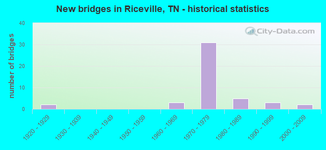
- New bridges - historical statistics
- 21920-1929
- 31960-1969
- 311970-1979
- 51980-1989
- 31990-1999
- 22000-2009


- Bridge Condition - Deck
- 70.8%Good
- 20.8%Satisfactory
- 8.3%Fair

- Bridge Condition - Superstructure
- 54.2%Good
- 45.8%Satisfactory

- Bridge Condition - Substructure
- 70.8%Good
- 29.2%Satisfactory

- Bridge Condition - Channel
- 36.0%Good
- 48.0%Satisfactory
- 16.0%Fair

- Bridge Condition - Culverts
- 36.4%Good
- 63.6%Satisfactory
Find on map >> Show street view
Structure Number: 54023190001, Location: 2MI EAST OF US11 (Lat: 35.343683, Lng: -84.689883), Route carried "on" structure: County highway 2319, Year Built: 1996, Status: Open, Structure Length: 2.29m (7.51ft), Average Daily Traffic: 180 (year 2020), Truck Traffic: 3%, Average Future Daily Traffic: 320 (year 2039), Design Load: HS 20, Features Intersected: OOSTANAULA CREEK
Minimum Vertical Clearance: 30+ m (98+ ft), Kilometerpoint: 2.382, Lanes on structure: 2, Owner: County Highway Agency, Approaching Roadway Width: 6.1m (20.0ft), Skew: 3 degrees, Material/Design: Prestressed concrete continuous, Design/Construction: Box Beam or Girders - Single/Spread, Number Of Spans In Main Unit: 2, Length of Maximum Span: 11.3m (37.1ft), Curb-To-Curb Width: 6.7m (22.0ft), Out-to-Out Width: 7.4m (24.3ft)
Condition: Deck: Good, Superstructure: Satisfactory, Substructure: Good, Channel: Good, Operating Rating: 45.9 metric tons, Method Used To Determine Operating Rating: Load Factor (LF), Inventory Rating: 27.9 metric tons, Method Used To Determine Inventory Rating: Load Factor (LF), Structural Evaluation: Equal to present minimum criteria, Deck Geometry: Meets minimum limits, Waterway Adequacy: Better than present minimum criteria, Approach Roadway Alignment: High priority of corrective action, Designated Inspection Frequency: Every 24 months, Inspection Date: July 2021, Deck Structure Type: Concrete Cast-file-Place, Wearing Surface/Protective System: Wearing Surface: Monolithic Concrete, Deck Protection: Epoxy Coated Reinforcing
Find on map >> Show street view
Structure Number: 54023230001, Location: WEST OF I75 (Lat: 35.400961, Lng: -84.768464), Route carried "on" structure: County highway 2323, Year Built: 1983, Status: Open, Structure Length: 1.55m (5.09ft), Average Daily Traffic: 168 (year 2020), Truck Traffic: 3%, Average Future Daily Traffic: 256 (year 2039), Design Load: HS 20, Features Intersected: ROGERS CREEK
Minimum Vertical Clearance: 30+ m (98+ ft), Kilometerpoint: 7.661, Lanes on structure: 2, Owner: County Highway Agency, Approaching Roadway Width: 4.3m (14.1ft), Skew: 1 degrees, Material/Design: Concrete continuous, Design/Construction: Culvert, Number Of Spans In Main Unit: 3, Length of Maximum Span: 4.6m (15.1ft), Curb-To-Curb Width: 6.5m (21.3ft), Out-to-Out Width: 7.8m (25.6ft)
Condition: Channel: Satisfactory, Culverts: Satisfactory, Operating Rating: 89.1 metric tons, Method Used To Determine Operating Rating: Load Factor (LF), Inventory Rating: 32.4 metric tons, Method Used To Determine Inventory Rating: Load Factor (LF), Structural Evaluation: Equal to present minimum criteria, Deck Geometry: Meets minimum limits, Waterway Adequacy: Better than present minimum criteria, Approach Roadway Alignment: Equal to present minimum criteria, Designated Inspection Frequency: Every 24 months, Inspection Date: July 2021, Deck Structure Type: Concrete Cast-file-Place, Wearing Surface/Protective System: Wearing Surface: Bituminous
Find on map >> Show street view
Structure Number: 54023230003, Location: WEST OF I75 (Lat: 35.418011, Lng: -84.762419), Route carried "on" structure: County highway 2323, Year Built: 1970, Status: Open, Structure Length: 1.62m (5.31ft), Average Daily Traffic: 168 (year 2020), Truck Traffic: 3%, Average Future Daily Traffic: 256 (year 2039), Design Load: H 20, Features Intersected: BRUSH CREEK
Minimum Vertical Clearance: 30+ m (98+ ft), Kilometerpoint: 9.688, Lanes on structure: 2, Owner: County Highway Agency, Approaching Roadway Width: 6.7m (22.0ft), Material/Design: Steel, Design/Construction: Stringer/Multi-beam, Number Of Spans In Main Unit: 2, Length of Maximum Span: 7.6m (24.9ft), Curb-To-Curb Width: 7.3m (24.0ft), Out-to-Out Width: 7.7m (25.3ft)
Condition: Deck: Good, Superstructure: Satisfactory, Substructure: Satisfactory, Channel: Satisfactory, Operating Rating: 40.5 metric tons, Method Used To Determine Operating Rating: Allowable Stress (AS), Inventory Rating: 25.2 metric tons, Method Used To Determine Inventory Rating: Allowable Stress (AS), Structural Evaluation: Equal to present minimum criteria, Deck Geometry: Somewhat better than minimum adequacy, Waterway Adequacy: Better than present minimum criteria, Approach Roadway Alignment: Equal to present desirable criteria, Length Of Structure Improvement: 1.62m (5.31ft), Designated Inspection Frequency: Every 24 months, Inspection Date: July 2021, Bridge Improvement Cost: $98,000, Roadway Improvement Cost: $10,000, Total Project Cost: $148,000 ( Estimate for 2019), Deck Structure Type: Concrete Cast-file-Place, Wearing Surface/Protective System: Wearing Surface: Bituminous
Find on map >> Show street view
Structure Number: 54023230005, Location: WEST 0F I75 (Lat: 35.434283, Lng: -84.745617), Route carried "on" structure: County highway 2323, Year Built: 1975, Status: Open, Structure Length: 0.94m (3.08ft), Average Daily Traffic: 168 (year 2020), Truck Traffic: 3%, Average Future Daily Traffic: 269 (year 2041), Design Load: H 20, Features Intersected: SHOALS CREEK
Minimum Vertical Clearance: 30+ m (98+ ft), Kilometerpoint: 12.183, Lanes on structure: 2, Owner: County Highway Agency, Approaching Roadway Width: 5.5m (18.0ft), Material/Design: Steel, Design/Construction: Stringer/Multi-beam, Number Of Spans In Main Unit: 1, Length of Maximum Span: 8.2m (26.9ft), Curb-To-Curb Width: 7.9m (25.9ft), Out-to-Out Width: 8.3m (27.2ft)
Condition: Deck: Good, Superstructure: Good, Substructure: Good, Channel: Fair, Operating Rating: 36.0 metric tons, Method Used To Determine Operating Rating: Allowable Stress (AS), Inventory Rating: 22.5 metric tons, Method Used To Determine Inventory Rating: Allowable Stress (AS), Structural Evaluation: Equal to present minimum criteria, Deck Geometry: Somewhat better than minimum adequacy, Waterway Adequacy: Better than present minimum criteria, Approach Roadway Alignment: Equal to present desirable criteria, Designated Inspection Frequency: Every 24 months, Inspection Date: July 2021, Deck Structure Type: Concrete Cast-file-Place, Wearing Surface/Protective System: Wearing Surface: Bituminous
Find on map >> Show street view
Structure Number: 540A3870001, Location: 6MI EAST OF US11 (Lat: 35.370017, Lng: -84.636617), Route carried "on" structure: County highway 387, Year Built: 1973, Status: Open, Structure Length: 2.80m (9.19ft), Average Daily Traffic: 190 (year 2022), Truck Traffic: 2%, Average Future Daily Traffic: 304 (year 2039), Design Load: H 15, Features Intersected: OOSTANULA CREEK
Minimum Vertical Clearance: 30+ m (98+ ft), Kilometerpoint: 3.634, Lanes on structure: 2, Owner: County Highway Agency, Approaching Roadway Width: 7.9m (25.9ft), Skew: 1 degrees, Material/Design: Steel, Design/Construction: Stringer/Multi-beam, Number Of Spans In Main Unit: 2, Length of Maximum Span: 14.9m (48.9ft), Curb-To-Curb Width: 7.3m (24.0ft), Out-to-Out Width: 7.7m (25.3ft)
Condition: Deck: Good, Superstructure: Satisfactory, Substructure: Satisfactory, Channel: Satisfactory, Operating Rating: 27.9 metric tons, Method Used To Determine Operating Rating: Load Factor (LF), Inventory Rating: 17.1 metric tons, Method Used To Determine Inventory Rating: Load Factor (LF), Structural Evaluation: Somewhat better than minimum adequacy, Deck Geometry: Somewhat better than minimum adequacy, Waterway Adequacy: Better than present minimum criteria, Approach Roadway Alignment: Equal to present minimum criteria, Length Of Structure Improvement: 2.80m (9.19ft), Designated Inspection Frequency: Every 24 months, Inspection Date: September 2021, Bridge Improvement Cost: $425,000, Roadway Improvement Cost: $43,000, Total Project Cost: $638,000 ( Estimate for 2019), Deck Structure Type: Concrete Cast-file-Place, Wearing Surface/Protective System: Wearing Surface: Monolithic Concrete
Find on map >> Show street view
Structure Number: 540A3900001, Location: 5MI EAST OF US11 (Lat: 35.367333, Lng: -84.640167), Route carried "on" structure: County highway 390, Year Built: 1973, Status: Open, Structure Length: 2.47m (8.10ft), Average Daily Traffic: 940 (year 2022), Truck Traffic: 2%, Average Future Daily Traffic: 1,504 (year 2039), Design Load: H 20, Features Intersected: OOSTANULA CREEK
Minimum Vertical Clearance: 30+ m (98+ ft), Kilometerpoint: 5.198, Lanes on structure: 2, Owner: County Highway Agency, Approaching Roadway Width: 7.6m (24.9ft), Skew: 1 degrees, Material/Design: Steel continuous, Design/Construction: Stringer/Multi-beam, Number Of Spans In Main Unit: 2, Length of Maximum Span: 11.9m (39.0ft), Curb-To-Curb Width: 7.3m (24.0ft), Out-to-Out Width: 7.7m (25.3ft)
Condition: Deck: Satisfactory, Superstructure: Good, Substructure: Satisfactory, Channel: Fair, Operating Rating: 44.1 metric tons, Method Used To Determine Operating Rating: Allowable Stress (AS), Inventory Rating: 32.4 metric tons, Method Used To Determine Inventory Rating: Allowable Stress (AS), Structural Evaluation: Equal to present minimum criteria, Deck Geometry: Meets minimum limits, Waterway Adequacy: Better than present minimum criteria, Approach Roadway Alignment: Equal to present desirable criteria, Length Of Structure Improvement: 2.47m (8.10ft), Designated Inspection Frequency: Every 24 months, Inspection Date: September 2021, Bridge Improvement Cost: $152,000, Roadway Improvement Cost: $16,000, Total Project Cost: $229,000 ( Estimate for 2019), Deck Structure Type: Concrete Cast-file-Place, Wearing Surface/Protective System: Wearing Surface: Monolithic Concrete
Find on map >> Show street view
Structure Number: 540A4300001, Location: .06 MI EAST OF SR2 (Lat: 35.381567, Lng: -84.692150), Route carried "on" structure: County highway 430, Year Built: 1973, Status: Open, Structure Length: 1.25m (4.10ft), Average Daily Traffic: 850 (year 2022), Truck Traffic: 2%, Average Future Daily Traffic: 1,360 (year 2039), Design Load: H 15, Features Intersected: DRY VALLEY CREEK
Minimum Vertical Clearance: 30+ m (98+ ft), Kilometerpoint: 0.095, Lanes on structure: 2, Owner: County Highway Agency, Approaching Roadway Width: 6.7m (22.0ft), Skew: 1 degrees, Material/Design: Steel, Design/Construction: Stringer/Multi-beam, Number Of Spans In Main Unit: 1, Length of Maximum Span: 12.2m (40.0ft), Curb-To-Curb Width: 7.3m (24.0ft), Out-to-Out Width: 7.7m (25.3ft)
Condition: Deck: Good, Superstructure: Good, Substructure: Good, Channel: Good, Operating Rating: 27.9 metric tons, Method Used To Determine Operating Rating: Load Factor (LF), Inventory Rating: 17.1 metric tons, Method Used To Determine Inventory Rating: Load Factor (LF), Structural Evaluation: Meets minimum limits, Deck Geometry: Meets minimum limits, Waterway Adequacy: Better than present minimum criteria, Approach Roadway Alignment: Equal to present desirable criteria, Length Of Structure Improvement: 1.25m (4.10ft), Designated Inspection Frequency: Every 24 months, Inspection Date: September 2021, Bridge Improvement Cost: $90,000, Roadway Improvement Cost: $10,000, Total Project Cost: $136,000 ( Estimate for 2019), Deck Structure Type: Concrete Cast-file-Place, Wearing Surface/Protective System: Wearing Surface: Bituminous
Find on map >> Show street view
Structure Number: 540A4300003, Location: 2MI EAST OF US11 (Lat: 35.376567, Lng: -84.666500), Route carried "on" structure: City street 430, Year Built: 1970, Status: Open, Structure Length: 0.76m (2.49ft), Average Daily Traffic: 850 (year 2022), Truck Traffic: 2%, Average Future Daily Traffic: 1,360 (year 2039), Design Load: HS 20, Features Intersected: BRANCH
Minimum Vertical Clearance: 30+ m (98+ ft), Kilometerpoint: 2.702, Lanes on structure: 2, Owner: County Highway Agency, Approaching Roadway Width: 7.3m (24.0ft), Material/Design: Concrete continuous, Design/Construction: Culvert, Number Of Spans In Main Unit: 2, Length of Maximum Span: 3.7m (12.1ft), Curb-To-Curb Width: 7.9m (25.9ft), Out-to-Out Width: 8.5m (27.9ft)
Condition: Channel: Satisfactory, Culverts: Satisfactory, Operating Rating: 60.3 metric tons, Method Used To Determine Operating Rating: Load Factor (LF), Inventory Rating: 32.4 metric tons, Method Used To Determine Inventory Rating: Load Factor (LF), Structural Evaluation: Equal to present minimum criteria, Deck Geometry: Somewhat better than minimum adequacy, Waterway Adequacy: Better than present minimum criteria, Approach Roadway Alignment: Equal to present desirable criteria, Designated Inspection Frequency: Every 24 months, Inspection Date: September 2021
Find on map >> Show street view
Structure Number: 540A4540001, Location: .5MI EAST OF I75 (Lat: 35.425500, Lng: -84.683333), Route carried "on" structure: County highway 454, Year Built: 1994, Status: Open, Structure Length: 3.66m (12.01ft), Average Daily Traffic: 310 (year 2022), Truck Traffic: 2%, Average Future Daily Traffic: 496 (year 2039), Design Load: HS 20, Features Intersected: NORTH MOUSE CREEK
Minimum Vertical Clearance: 30+ m (98+ ft), Kilometerpoint: 2.805, Lanes on structure: 2, Owner: County Highway Agency, Approaching Roadway Width: 6.7m (22.0ft), Skew: 1 degrees, Material/Design: Prestressed concrete continuous, Design/Construction: Box Beam or Girders - Single/Spread, Number Of Spans In Main Unit: 2, Length of Maximum Span: 18.3m (60.0ft), Curb-To-Curb Width: 6.7m (22.0ft), Out-to-Out Width: 7.4m (24.3ft)
Condition: Deck: Good, Superstructure: Satisfactory, Substructure: Good, Channel: Good, Operating Rating: 54.9 metric tons, Method Used To Determine Operating Rating: Load Factor (LF), Inventory Rating: 32.4 metric tons, Method Used To Determine Inventory Rating: Load Factor (LF), Structural Evaluation: Equal to present minimum criteria, Deck Geometry: Meets minimum limits, Waterway Adequacy: Better than present minimum criteria, Approach Roadway Alignment: Equal to present minimum criteria, Length Of Structure Improvement: 3.66m (12.01ft), Designated Inspection Frequency: Every 24 months, Inspection Date: September 2021, Bridge Improvement Cost: $198,000, Roadway Improvement Cost: $20,000, Total Project Cost: $298,000 ( Estimate for 2019), Deck Structure Type: Concrete Cast-file-Place, Wearing Surface/Protective System: Wearing Surface: Monolithic Concrete, Deck Protection: Epoxy Coated Reinforcing
Find on map >> Show street view
Structure Number: 540A4540003, Location: 2MI WEST OF I75 (Lat: 35.440883, Lng: -84.705000), Route carried "on" structure: County highway 454, Year Built: 1986, Status: Open, Structure Length: 1.55m (5.09ft), Average Daily Traffic: 100 (year 2022), Truck Traffic: 2%, Average Future Daily Traffic: 160 (year 2039), Design Load: HS 20, Features Intersected: SPRING CREEK
Minimum Vertical Clearance: 30+ m (98+ ft), Kilometerpoint: 5.990, Lanes on structure: 2, Owner: County Highway Agency, Approaching Roadway Width: 5.5m (18.0ft), Skew: 1 degrees, Material/Design: Concrete continuous, Design/Construction: Culvert, Number Of Spans In Main Unit: 3, Length of Maximum Span: 4.6m (15.1ft), Curb-To-Curb Width: 6.8m (22.3ft), Out-to-Out Width: 7.9m (25.9ft)
Condition: Channel: Fair, Culverts: Satisfactory, Operating Rating: 52.2 metric tons, Method Used To Determine Operating Rating: Load Factor (LF), Inventory Rating: 32.4 metric tons, Method Used To Determine Inventory Rating: Load Factor (LF), Structural Evaluation: Equal to present minimum criteria, Deck Geometry: Somewhat better than minimum adequacy, Waterway Adequacy: Better than present minimum criteria, Approach Roadway Alignment: Equal to present desirable criteria, Designated Inspection Frequency: Every 24 months, Inspection Date: September 2021, Deck Structure Type: Concrete Cast-file-Place, Wearing Surface/Protective System: Wearing Surface: Monolithic Concrete
Find on map >> Show street view
Structure Number: 540A4550001, Location: 1MI EAST OF I75 (Lat: 35.407500, Lng: -84.688333), Route carried "on" structure: County highway 455, Year Built: 1988, Status: Open, Structure Length: 4.11m (13.48ft), Average Daily Traffic: 70 (year 2022), Truck Traffic: 2%, Average Future Daily Traffic: 112 (year 2039), Design Load: HS 20, Features Intersected: NORTH MOUSE CREEK
Minimum Vertical Clearance: 30+ m (98+ ft), Kilometerpoint: 2.969, Lanes on structure: 2, Owner: County Highway Agency, Approaching Roadway Width: 9.1m (29.9ft), Material/Design: Prestressed concrete continuous, Design/Construction: Box Beam or Girders - Single/Spread, Number Of Spans In Main Unit: 3, Length of Maximum Span: 13.7m (44.9ft), Curb-To-Curb Width: 7.3m (24.0ft), Out-to-Out Width: 9.1m (29.9ft)
Condition: Deck: Good, Superstructure: Good, Substructure: Good, Channel: Good, Operating Rating: 38.7 metric tons, Method Used To Determine Operating Rating: Load Factor (LF), Inventory Rating: 23.4 metric tons, Method Used To Determine Inventory Rating: Load Factor (LF), Structural Evaluation: Equal to present minimum criteria, Deck Geometry: Equal to present minimum criteria, Waterway Adequacy: Equal to present desirable criteria, Approach Roadway Alignment: Equal to present minimum criteria, Designated Inspection Frequency: Every 24 months, Inspection Date: September 2021, Deck Structure Type: Concrete Precast Panels, Wearing Surface/Protective System: Wearing Surface: Monolithic Concrete
Find on map >> Show street view
Structure Number: 540A4550003, Location: 1MI WEST OF I75 (Lat: 35.433817, Lng: -84.707100), Route carried "on" structure: County highway 455, Year Built: 1975, Status: Posted for load, Structure Length: 1.01m (3.31ft), Average Daily Traffic: 100 (year 2022), Truck Traffic: 2%, Average Future Daily Traffic: 160 (year 2040), Design Load: H 10, Features Intersected: SPRING CREEK
Minimum Vertical Clearance: 30+ m (98+ ft), Kilometerpoint: 5.866, Lanes on structure: 2, Owner: County Highway Agency, Approaching Roadway Width: 6.7m (22.0ft), Skew: 1 degrees, Material/Design: Steel, Design/Construction: Stringer/Multi-beam, Number Of Spans In Main Unit: 1, Length of Maximum Span: 9.1m (29.9ft), Curb-To-Curb Width: 8.7m (28.5ft), Out-to-Out Width: 9.1m (29.9ft)
Condition: Deck: Fair, Superstructure: Satisfactory, Substructure: Good, Channel: Satisfactory, Operating Rating: 26.1 metric tons, Method Used To Determine Operating Rating: Load Factor (LF), Inventory Rating: 17.1 metric tons, Method Used To Determine Inventory Rating: Load Factor (LF), Structural Evaluation: Somewhat better than minimum adequacy, Deck Geometry: Better than present minimum criteria, Waterway Adequacy: Better than present minimum criteria, Approach Roadway Alignment: Equal to present minimum criteria, Bridge Posting: Required (Relationship of Operating Rating to Maximum Legal Load: 0.1 - 9.9% below), Length Of Structure Improvement: 1.01m (3.31ft), Designated Inspection Frequency: Every 24 months, Inspection Date: September 2021, Bridge Improvement Cost: $161,000, Roadway Improvement Cost: $17,000, Total Project Cost: $242,000 ( Estimate for 2020), Deck Structure Type: Concrete Cast-file-Place, Wearing Surface/Protective System: Wearing Surface: Bituminous
Find on map >> Show street view
Structure Number: 540A5230001, Location: WEST OF I75 (Lat: 35.384333, Lng: -84.751333), Route carried "on" structure: County highway 523, Year Built: 1987, Status: Open, Structure Length: 1.04m (3.41ft), Average Daily Traffic: 70 (year 2022), Truck Traffic: 2%, Average Future Daily Traffic: 112 (year 2039), Design Load: HS 20, Features Intersected: SPRING CREEK
Minimum Vertical Clearance: 30+ m (98+ ft), Kilometerpoint: 0.269, Lanes on structure: 2, Owner: County Highway Agency, Approaching Roadway Width: 5.5m (18.0ft), Skew: 1 degrees, Material/Design: Concrete continuous, Design/Construction: Culvert, Number Of Spans In Main Unit: 2, Length of Maximum Span: 4.6m (15.1ft), Curb-To-Curb Width: 6.9m (22.6ft), Out-to-Out Width: 8.0m (26.2ft)
Condition: Channel: Satisfactory, Culverts: Satisfactory, Operating Rating: 89.1 metric tons, Method Used To Determine Operating Rating: Load Factor (LF), Inventory Rating: 32.4 metric tons, Method Used To Determine Inventory Rating: Load Factor (LF), Structural Evaluation: Equal to present minimum criteria, Deck Geometry: Somewhat better than minimum adequacy, Waterway Adequacy: Better than present minimum criteria, Approach Roadway Alignment: Equal to present desirable criteria, Designated Inspection Frequency: Every 24 months, Inspection Date: September 2021, Deck Structure Type: Concrete Cast-file-Place, Wearing Surface/Protective System: Wearing Surface: Monolithic Concrete
Find on map >> Show street view
Structure Number: 540A5250001, Location: WEST OF I75 (Lat: 35.424050, Lng: -84.746317), Route carried "on" structure: County highway 525, Year Built: 2003, Status: Open, Structure Length: 2.16m (7.09ft), Average Daily Traffic: 100 (year 2022), Truck Traffic: 2%, Average Future Daily Traffic: 160 (year 2039), Features Intersected: ROGERS CREEK
Minimum Vertical Clearance: 30+ m (98+ ft), Kilometerpoint: 0.494, Lanes on structure: 2, Owner: County Highway Agency, Approaching Roadway Width: 5.5m (18.0ft), Skew: 1 degrees, Material/Design: Prestressed concrete, Design/Construction: Box Beam or Girders - Single/Spread, Number Of Spans In Main Unit: 1, Length of Maximum Span: 20.7m (67.9ft), Curb-To-Curb Width: 6.7m (22.0ft), Out-to-Out Width: 7.4m (24.3ft)
Condition: Deck: Good, Superstructure: Good, Substructure: Good, Channel: Good, Operating Rating: 72.0 metric tons, Method Used To Determine Operating Rating: Load Factor (LF), Inventory Rating: 32.4 metric tons, Method Used To Determine Inventory Rating: Load Factor (LF), Structural Evaluation: Better than present minimum criteria, Deck Geometry: Somewhat better than minimum adequacy, Waterway Adequacy: Better than present minimum criteria, Approach Roadway Alignment: Equal to present desirable criteria, Designated Inspection Frequency: Every 24 months, Inspection Date: September 2021, Deck Structure Type: Concrete Precast Panels, Wearing Surface/Protective System: Wearing Surface: Monolithic Concrete, Deck Protection: Epoxy Coated Reinforcing
Find on map >> Show street view
Structure Number: 54I00750007, Location: 4.6 MI. FROM BRADLEY CO. (Lat: 35.358161, Lng: -84.741731), Route carried "on" structure: Interstate 75, Year Built: 1971, Status: Open, Structure Length: 2.74m (8.99ft), Average Daily Traffic: 43,461 (year 2020), Truck Traffic: 35%, Average Future Daily Traffic: 69,376 (year 2040), Design Load: HS 20+Mod, Features Intersected: NFA 2334
Minimum Vertical Clearance: 30+ m (98+ ft), Kilometerpoint: 7.483, Lanes on structure: 2, Lanes under structure: 2, Base Highway Network: Yes, Owner: State Highway Agency, Approaching Roadway Width: 12.8m (42.0ft), Skew: 10 degrees, Material/Design: Prestressed concrete, Design/Construction: Box Beam or Girders - Single/Spread, Number Of Spans In Main Unit: 1, Length of Maximum Span: 27.4m (89.9ft), Curb-To-Curb Width: 12.8m (42.0ft), Out-to-Out Width: 13.4m (44.0ft)
Condition: Deck: Good, Superstructure: Satisfactory, Substructure: Satisfactory, Operating Rating: 46.8 metric tons, Method Used To Determine Operating Rating: Load Factor (LF), Inventory Rating: 32.4 metric tons, Method Used To Determine Inventory Rating: Load Factor (LF), Structural Evaluation: Equal to present minimum criteria, Deck Geometry: Equal to present desirable criteria, Underclear: Somewhat better than minimum adequacy, Approach Roadway Alignment: Equal to present desirable criteria, Designated Inspection Frequency: Every 24 months, Inspection Date: April 2020, Deck Structure Type: Concrete Cast-file-Place, Wearing Surface/Protective System: Wearing Surface: Bituminous
Find on map >> Show street view
Structure Number: 54I00750008, Location: 4.6 MI. FROM BRADLEY CO. (Lat: 35.358633, Lng: -84.742750), Route carried "on" structure: Interstate 75, Year Built: 1971, Status: Open, Structure Length: 2.74m (8.99ft), Average Daily Traffic: 43,461 (year 2020), Truck Traffic: 35%, Average Future Daily Traffic: 69,376 (year 2040), Design Load: HS 20+Mod, Features Intersected: NFA 2334
Minimum Vertical Clearance: 30+ m (98+ ft), Kilometerpoint: 7.483, Lanes on structure: 2, Lanes under structure: 2, Base Highway Network: Yes, Owner: State Highway Agency, Approaching Roadway Width: 12.8m (42.0ft), Skew: 10 degrees, Material/Design: Prestressed concrete, Design/Construction: Box Beam or Girders - Single/Spread, Number Of Spans In Main Unit: 1, Length of Maximum Span: 27.4m (89.9ft), Curb-To-Curb Width: 12.8m (42.0ft), Out-to-Out Width: 13.4m (44.0ft)
Condition: Deck: Satisfactory, Superstructure: Satisfactory, Substructure: Good, Operating Rating: 46.8 metric tons, Method Used To Determine Operating Rating: Load Factor (LF), Inventory Rating: 31.5 metric tons, Method Used To Determine Inventory Rating: Load Factor (LF), Structural Evaluation: Equal to present minimum criteria, Deck Geometry: Equal to present desirable criteria, Underclear: Somewhat better than minimum adequacy, Approach Roadway Alignment: Equal to present desirable criteria, Designated Inspection Frequency: Every 24 months, Inspection Date: April 2020, Deck Structure Type: Concrete Cast-file-Place, Wearing Surface/Protective System: Wearing Surface: Bituminous
Find on map >> Show street view
Structure Number: 54I00750009, Location: 7.3 MI. FROM BRADLEY CO. (Lat: 35.390000, Lng: -84.718333), Route carried "on" structure: Interstate 75, Year Built: 1972, Status: Open, Structure Length: 2.90m (9.51ft), Average Daily Traffic: 43,461 (year 2020), Truck Traffic: 35%, Average Future Daily Traffic: 69,376 (year 2040), Design Load: HS 20+Mod, Features Intersected: SR 39
Minimum Vertical Clearance: 30+ m (98+ ft), Kilometerpoint: 11.764, Lanes on structure: 2, Lanes under structure: 2, Base Highway Network: Yes, Owner: State Highway Agency, Approaching Roadway Width: 12.8m (42.0ft), Skew: 10 degrees, Material/Design: Prestressed concrete, Design/Construction: Box Beam or Girders - Single/Spread, Number Of Spans In Main Unit: 1, Length of Maximum Span: 29.0m (95.1ft), Curb-To-Curb Width: 12.8m (42.0ft), Out-to-Out Width: 13.4m (44.0ft)
Condition: Deck: Good, Superstructure: Satisfactory, Substructure: Good, Operating Rating: 41.4 metric tons, Method Used To Determine Operating Rating: Load Factor (LF), Inventory Rating: 32.4 metric tons, Method Used To Determine Inventory Rating: Load Factor (LF), Structural Evaluation: Equal to present minimum criteria, Deck Geometry: Equal to present desirable criteria, Underclear: Equal to present minimum criteria, Approach Roadway Alignment: Equal to present desirable criteria, Designated Inspection Frequency: Every 24 months, Inspection Date: April 2020, Deck Structure Type: Concrete Cast-file-Place, Wearing Surface/Protective System: Wearing Surface: Bituminous, Membrane: Preformed Fabric
Find on map >> Show street view
Structure Number: 54I0075001, Location: 7.3 MI. FROM BRADLEY CO. (Lat: 35.390000, Lng: -84.718333), Route carried "on" structure: Interstate 75, Year Built: 1972, Status: Open, Structure Length: 2.90m (9.51ft), Average Daily Traffic: 43,461 (year 2020), Truck Traffic: 35%, Average Future Daily Traffic: 69,376 (year 2040), Design Load: HS 20+Mod, Features Intersected: NFA 1231
Minimum Vertical Clearance: 30+ m (98+ ft), Kilometerpoint: 11.780, Lanes on structure: 2, Lanes under structure: 2, Base Highway Network: Yes, Owner: State Highway Agency, Approaching Roadway Width: 12.8m (42.0ft), Skew: 12 degrees, Material/Design: Prestressed concrete, Design/Construction: Box Beam or Girders - Single/Spread, Number Of Spans In Main Unit: 1, Length of Maximum Span: 29.0m (95.1ft), Curb-To-Curb Width: 12.8m (42.0ft), Out-to-Out Width: 13.4m (44.0ft)
Condition: Deck: Satisfactory, Superstructure: Satisfactory, Substructure: Satisfactory, Operating Rating: 41.4 metric tons, Method Used To Determine Operating Rating: Load Factor (LF), Inventory Rating: 32.4 metric tons, Method Used To Determine Inventory Rating: Load Factor (LF), Structural Evaluation: Equal to present minimum criteria, Deck Geometry: Equal to present desirable criteria, Underclear: Equal to present minimum criteria, Approach Roadway Alignment: Equal to present desirable criteria, Designated Inspection Frequency: Every 24 months, Inspection Date: April 2020, Deck Structure Type: Concrete Cast-file-Place, Wearing Surface/Protective System: Wearing Surface: Bituminous, Membrane: Preformed Fabric
Find on map >> Show street view
Structure Number: 54I00750011, Location: 5 MI FROM SR2 (Lat: 35.405667, Lng: -84.705050), Route carried "on" structure: County highway 5408, Year Built: 1971, Status: Open, Structure Length: 5.27m (17.29ft), Average Daily Traffic: 312 (year 2020), Truck Traffic: 3%, Average Future Daily Traffic: 499 (year 2041), Design Load: H 20, Features Intersected: I75 NBL, Facility Carried by Structure: NFA A446
Minimum Vertical Clearance: 30+ m (98+ ft), Kilometerpoint: 9.930, Lanes on structure: 2, Lanes under structure: 2, Owner: State Highway Agency, Approaching Roadway Width: 9.8m (32.2ft), Material/Design: Prestressed concrete, Design/Construction: Box Beam or Girders - Multiple, Number Of Spans In Main Unit: 3, Length of Maximum Span: 26.5m (86.9ft), Curb-To-Curb Width: 8.7m (28.5ft), Out-to-Out Width: 9.8m (32.2ft)
Condition: Deck: Good, Superstructure: Satisfactory, Substructure: Good, Operating Rating: 52.2 metric tons, Method Used To Determine Operating Rating: Load and Resistance Factor Rating (LRFR) rating reported by rating factor(RF) method using HL-93 loadings, Inventory Rating: 40.2 metric tons, Method Used To Determine Inventory Rating: Load and Resistance Factor Rating (LRFR) rating reported by rating factor(RF) method using HL-93 loadings, Structural Evaluation: Equal to present minimum criteria, Deck Geometry: Equal to present minimum criteria, Underclear: Somewhat better than minimum adequacy, Approach Roadway Alignment: Equal to present desirable criteria, Designated Inspection Frequency: Every 24 months, Inspection Date: April 2020, Deck Structure Type: Concrete Cast-file-Place, Wearing Surface/Protective System: Wearing Surface: Monolithic Concrete
Find on map >> Show street view
Structure Number: 54I00750013, Location: 9.4 MI. FROM BRADLEY CO. (Lat: 35.415000, Lng: -84.696667), Route carried "on" structure: Interstate 75, Year Built: 1972, Status: Open, Structure Length: 3.69m (12.11ft), Average Daily Traffic: 42,070 (year 2020), Truck Traffic: 36%, Average Future Daily Traffic: 68,000 (year 2040), Design Load: HS 20+Mod, Features Intersected: NFA A455
Minimum Vertical Clearance: 30+ m (98+ ft), Kilometerpoint: 15.224, Lanes on structure: 2, Lanes under structure: 2, Base Highway Network: Yes, Owner: State Highway Agency, Approaching Roadway Width: 12.8m (42.0ft), Skew: 11 degrees, Material/Design: Concrete continuous, Design/Construction: Tee Beam, Number Of Spans In Main Unit: 3, Length of Maximum Span: 16.8m (55.1ft), Curb-To-Curb Width: 12.8m (42.0ft), Out-to-Out Width: 13.4m (44.0ft)
Condition: Deck: Good, Superstructure: Good, Substructure: Good, Operating Rating: 43.2 metric tons, Method Used To Determine Operating Rating: Load Factor (LF), Inventory Rating: 25.8 metric tons, Method Used To Determine Inventory Rating: Load Factor (LF), Structural Evaluation: Equal to present minimum criteria, Deck Geometry: Equal to present desirable criteria, Underclear: Equal to present minimum criteria, Approach Roadway Alignment: Equal to present desirable criteria, Designated Inspection Frequency: Every 24 months, Inspection Date: April 2020, Deck Structure Type: Concrete Cast-file-Place, Wearing Surface/Protective System: Wearing Surface: Bituminous, Membrane: Preformed Fabric
Find on map >> Show street view
Structure Number: 54I00750014, Location: 9.4 MI.FROM BRADLEY CO. (Lat: 35.415000, Lng: -84.696667), Route carried "on" structure: Interstate 75, Year Built: 1972, Status: Open, Structure Length: 3.90m (12.80ft), Average Daily Traffic: 42,070 (year 2020), Truck Traffic: 36%, Average Future Daily Traffic: 67,312 (year 2042), Design Load: HS 20+Mod, Features Intersected: NFA A455
Minimum Vertical Clearance: 30+ m (98+ ft), Kilometerpoint: 15.241, Lanes on structure: 2, Lanes under structure: 2, Base Highway Network: Yes, Owner: State Highway Agency, Approaching Roadway Width: 12.8m (42.0ft), Skew: 12 degrees, Material/Design: Concrete continuous, Design/Construction: Tee Beam, Number Of Spans In Main Unit: 3, Length of Maximum Span: 16.8m (55.1ft), Curb-To-Curb Width: 12.8m (42.0ft), Out-to-Out Width: 13.4m (44.0ft)
Condition: Deck: Good, Superstructure: Good, Substructure: Good, Operating Rating: 40.5 metric tons, Method Used To Determine Operating Rating: Load and Resistance Factor Rating (LRFR) rating reported by rating factor(RF) method using HL-93 loadings, Inventory Rating: 30.8 metric tons, Method Used To Determine Inventory Rating: Load and Resistance Factor Rating (LRFR) rating reported by rating factor(RF) method using HL-93 loadings, Structural Evaluation: Better than present minimum criteria, Deck Geometry: Equal to present desirable criteria, Underclear: Equal to present minimum criteria, Approach Roadway Alignment: Equal to present desirable criteria, Designated Inspection Frequency: Every 24 months, Inspection Date: April 2020, Deck Structure Type: Concrete Cast-file-Place, Wearing Surface/Protective System: Wearing Surface: Bituminous, Membrane: Preformed Fabric
Find on map >> Show street view
Structure Number: 54I00750015, Location: 10.8 MI. FROM BRADLEY CO. (Lat: 35.431667, Lng: -84.683333), Route carried "on" structure: Interstate 75, Year Built: 1972, Status: Open, Structure Length: 3.99m (13.09ft), Average Daily Traffic: 42,070 (year 2020), Truck Traffic: 36%, Average Future Daily Traffic: 68,000 (year 2040), Design Load: HS 20+Mod, Features Intersected: NFA A454
Minimum Vertical Clearance: 30+ m (98+ ft), Kilometerpoint: 17.429, Lanes on structure: 2, Lanes under structure: 2, Base Highway Network: Yes, Owner: State Highway Agency, Approaching Roadway Width: 12.8m (42.0ft), Skew: 10 degrees, Material/Design: Prestressed concrete continuous, Design/Construction: Stringer/Multi-beam, Number Of Spans In Main Unit: 3, Length of Maximum Span: 18.6m (61.0ft), Curb-To-Curb Width: 12.8m (42.0ft), Out-to-Out Width: 13.4m (44.0ft)
Condition: Deck: Good, Superstructure: Good, Substructure: Good, Operating Rating: 42.3 metric tons, Method Used To Determine Operating Rating: Load Factor (LF), Inventory Rating: 32.4 metric tons, Method Used To Determine Inventory Rating: Load Factor (LF), Structural Evaluation: Better than present minimum criteria, Deck Geometry: Equal to present desirable criteria, Underclear: Equal to present minimum criteria, Approach Roadway Alignment: Equal to present desirable criteria, Designated Inspection Frequency: Every 24 months, Inspection Date: April 2020, Deck Structure Type: Concrete Cast-file-Place, Wearing Surface/Protective System: Wearing Surface: Bituminous
Find on map >> Show street view
Structure Number: 54I00750016, Location: 10.8 MI.FROM BRADLEY CO. (Lat: 35.431667, Lng: -84.683333), Route carried "on" structure: Interstate 75, Year Built: 1972, Status: Open, Structure Length: 4.08m (13.39ft), Average Daily Traffic: 42,070 (year 2020), Truck Traffic: 36%, Average Future Daily Traffic: 68,000 (year 2040), Design Load: HS 20+Mod, Features Intersected: NFA A454
Minimum Vertical Clearance: 30+ m (98+ ft), Kilometerpoint: 17.429, Lanes on structure: 2, Lanes under structure: 2, Base Highway Network: Yes, Owner: State Highway Agency, Approaching Roadway Width: 12.8m (42.0ft), Skew: 10 degrees, Material/Design: Prestressed concrete continuous, Design/Construction: Stringer/Multi-beam, Number Of Spans In Main Unit: 3, Length of Maximum Span: 18.6m (61.0ft), Curb-To-Curb Width: 12.8m (42.0ft), Out-to-Out Width: 13.4m (44.0ft)
Condition: Deck: Good, Superstructure: Good, Substructure: Good, Operating Rating: 42.3 metric tons, Method Used To Determine Operating Rating: Load Factor (LF), Inventory Rating: 32.4 metric tons, Method Used To Determine Inventory Rating: Load Factor (LF), Structural Evaluation: Better than present minimum criteria, Deck Geometry: Equal to present desirable criteria, Underclear: Equal to present minimum criteria, Approach Roadway Alignment: Equal to present desirable criteria, Designated Inspection Frequency: Every 24 months, Inspection Date: April 2020, Deck Structure Type: Concrete Cast-file-Place, Wearing Surface/Protective System: Wearing Surface: Bituminous
Find on map >> Show street view
Structure Number: 54I00750049, Location: 5 MI FROM SR2 (Lat: 35.406717, Lng: -84.706900), Route carried "on" structure: County highway 5408, Year Built: 1971, Status: Open, Structure Length: 5.27m (17.29ft), Average Daily Traffic: 312 (year 2020), Truck Traffic: 3%, Average Future Daily Traffic: 496 (year 2040), Design Load: H 20, Features Intersected: I75 SBL, Facility Carried by Structure: NFA A446
Minimum Vertical Clearance: 30+ m (98+ ft), Kilometerpoint: 9.801, Lanes on structure: 2, Lanes under structure: 2, Owner: State Highway Agency, Approaching Roadway Width: 9.8m (32.2ft), Material/Design: Prestressed concrete, Design/Construction: Box Beam or Girders - Multiple, Number Of Spans In Main Unit: 3, Length of Maximum Span: 26.5m (86.9ft), Curb-To-Curb Width: 8.6m (28.2ft), Out-to-Out Width: 9.8m (32.2ft)
Condition: Deck: Satisfactory, Superstructure: Satisfactory, Substructure: Good, Operating Rating: 44.1 metric tons, Method Used To Determine Operating Rating: Field evaluation and documented engineering judgment, Inventory Rating: 32.4 metric tons, Method Used To Determine Inventory Rating: Field evaluation and documented engineering judgment, Structural Evaluation: Equal to present minimum criteria, Deck Geometry: Equal to present minimum criteria, Underclear: Somewhat better than minimum adequacy, Approach Roadway Alignment: Equal to present desirable criteria, Designated Inspection Frequency: Every 24 months, Inspection Date: April 2020, Deck Structure Type: Concrete Cast-file-Place, Wearing Surface/Protective System: Wearing Surface: Monolithic Concrete
Find on map >> Show street view
Structure Number: 54S43720003, Location: 2MI EAST OF US11 (Lat: 35.372058, Lng: -84.668325), Route carried "on" structure: County highway 1227, Year Built: 1997, Status: Open, Structure Length: 1.13m (3.71ft), Average Daily Traffic: 1,068 (year 2020), Truck Traffic: 3%, Average Future Daily Traffic: 1,709 (year 2041), Design Load: HS 20, Features Intersected: BRANCH
Minimum Vertical Clearance: 30+ m (98+ ft), Kilometerpoint: 1.336, Lanes on structure: 2, Owner: County Highway Agency, Approaching Roadway Width: 7.3m (24.0ft), Skew: 4 degrees, Material/Design: Concrete continuous, Design/Construction: Culvert, Number Of Spans In Main Unit: 2, Length of Maximum Span: 5.2m (17.1ft), Curb-To-Curb Width: 7.7m (25.3ft), Out-to-Out Width: 9.3m (30.5ft)
Condition: Channel: Fair, Culverts: Good, Operating Rating: 89.1 metric tons, Method Used To Determine Operating Rating: Load Factor (LF), Inventory Rating: 32.4 metric tons, Method Used To Determine Inventory Rating: Load Factor (LF), Structural Evaluation: Better than present minimum criteria, Deck Geometry: Meets minimum limits, Waterway Adequacy: Equal to present minimum criteria, Approach Roadway Alignment: Equal to present desirable criteria, Designated Inspection Frequency: Every 24 months, Inspection Date: July 2021, Deck Structure Type: Concrete Cast-file-Place, Wearing Surface/Protective System: Wearing Surface: Bituminous, Deck Protection: Epoxy Coated Reinforcing
Find on map >> Show street view
Structure Number: 54S43730001, Location: 2 MI WEST OF US11 (Lat: 35.356017, Lng: -84.732617), Route carried "on" structure: County highway 2334, Year Built: 1970, Status: Open, Structure Length: 1.37m (4.49ft), Average Daily Traffic: 345 (year 2020), Truck Traffic: 3%, Average Future Daily Traffic: 544 (year 2039), Design Load: HS 20, Features Intersected: DRY VALLEY CREEK
Minimum Vertical Clearance: 30+ m (98+ ft), Kilometerpoint: 2.221, Lanes on structure: 2, Owner: County Highway Agency, Approaching Roadway Width: 5.5m (18.0ft), Skew: 3 degrees, Material/Design: Concrete continuous, Design/Construction: Culvert, Number Of Spans In Main Unit: 3, Length of Maximum Span: 3.7m (12.1ft), Curb-To-Curb Width: 14.3m (46.9ft), Out-to-Out Width: 15.6m (51.2ft)
Condition: Channel: Satisfactory, Culverts: Satisfactory, Operating Rating: 74.7 metric tons, Method Used To Determine Operating Rating: Load Factor (LF), Inventory Rating: 32.4 metric tons, Method Used To Determine Inventory Rating: Load Factor (LF), Structural Evaluation: Equal to present minimum criteria, Deck Geometry: Superior to present desirable criteria, Waterway Adequacy: Better than present minimum criteria, Approach Roadway Alignment: Equal to present desirable criteria, Designated Inspection Frequency: Every 24 months, Inspection Date: July 2021
Find on map >> Show street view
Structure Number: 54S43730003, Location: .8MI EAST OF I75 (Lat: 35.356981, Lng: -84.734644), Route carried "on" structure: County highway 2334, Year Built: 1970, Status: Open, Structure Length: 3.47m (11.38ft), Average Daily Traffic: 476 (year 2020), Truck Traffic: 3%, Average Future Daily Traffic: 762 (year 2041), Design Load: H 15, Features Intersected: NORTH MOUSE CREEK
Minimum Vertical Clearance: 30+ m (98+ ft), Kilometerpoint: 2.430, Lanes on structure: 2, Owner: County Highway Agency, Approaching Roadway Width: 11.0m (36.1ft), Material/Design: Prestressed concrete continuous, Design/Construction: Stringer/Multi-beam, Number Of Spans In Main Unit: 3, Length of Maximum Span: 11.6m (38.1ft), Curb-To-Curb Width: 8.7m (28.5ft), Out-to-Out Width: 9.9m (32.5ft)
Condition: Deck: Good, Superstructure: Good, Substructure: Good, Channel: Good, Operating Rating: 54.0 metric tons, Method Used To Determine Operating Rating: Load Factor (LF), Inventory Rating: 29.7 metric tons, Method Used To Determine Inventory Rating: Load Factor (LF), Structural Evaluation: Better than present minimum criteria, Deck Geometry: Somewhat better than minimum adequacy, Waterway Adequacy: Better than present minimum criteria, Approach Roadway Alignment: Equal to present desirable criteria, Designated Inspection Frequency: Every 24 months, Inspection Date: July 2021, Deck Structure Type: Concrete Cast-file-Place, Wearing Surface/Protective System: Wearing Surface: Monolithic Concrete
Find on map >> Show street view
Structure Number: 54S43730005, Location: WEST OF I75 (Lat: 35.366653, Lng: -84.763269), Route carried "on" structure: County highway 2334, Year Built: 1987, Status: Open, Structure Length: 1.58m (5.18ft), Average Daily Traffic: 476 (year 2020), Truck Traffic: 3%, Average Future Daily Traffic: 608 (year 2039), Design Load: HS 20, Features Intersected: SPRING CREEK
Minimum Vertical Clearance: 30+ m (98+ ft), Kilometerpoint: 5.761, Lanes on structure: 2, Owner: County Highway Agency, Approaching Roadway Width: 6.1m (20.0ft), Skew: 4 degrees, Material/Design: Concrete continuous, Design/Construction: Culvert, Number Of Spans In Main Unit: 3, Length of Maximum Span: 3.7m (12.1ft), Curb-To-Curb Width: 8.6m (28.2ft), Out-to-Out Width: 9.7m (31.8ft)
Condition: Channel: Good, Culverts: Satisfactory, Operating Rating: 68.4 metric tons, Method Used To Determine Operating Rating: Load Factor (LF), Inventory Rating: 32.4 metric tons, Method Used To Determine Inventory Rating: Load Factor (LF), Structural Evaluation: Equal to present minimum criteria, Deck Geometry: Somewhat better than minimum adequacy, Waterway Adequacy: Better than present minimum criteria, Approach Roadway Alignment: Equal to present desirable criteria, Designated Inspection Frequency: Every 24 months, Inspection Date: July 2021, Deck Structure Type: Concrete Cast-file-Place, Wearing Surface/Protective System: Wearing Surface: Monolithic Concrete
Find on map >> Show street view
Structure Number: 54S43740005, Location: 3MI EAST OF US11 (Lat: 35.350714, Lng: -84.671814), Route carried "on" structure: County highway 1196, Year Built: 1961, Status: Open, Structure Length: 3.47m (11.38ft), Average Daily Traffic: 1,426 (year 2020), Truck Traffic: 3%, Average Future Daily Traffic: 2,282 (year 2041), Design Load: H 15, Features Intersected: OOSTANAULA CREEK
Minimum Vertical Clearance: 30+ m (98+ ft), Kilometerpoint: 5.037, Lanes on structure: 2, Owner: County Highway Agency, Approaching Roadway Width: 8.5m (27.9ft), Material/Design: Concrete, Design/Construction: Tee Beam, Number Of Spans In Main Unit: 4, Length of Maximum Span: 8.8m (28.9ft), Curb-To-Curb Width: 7.3m (24.0ft), Out-to-Out Width: 8.7m (28.5ft)
Condition: Deck: Good, Superstructure: Good, Substructure: Good, Channel: Satisfactory, Operating Rating: 75.6 metric tons, Method Used To Determine Operating Rating: Load Factor (LF), Inventory Rating: 32.4 metric tons, Method Used To Determine Inventory Rating: Load Factor (LF), Structural Evaluation: Better than present minimum criteria, Deck Geometry: Meets minimum limits, Waterway Adequacy: Better than present minimum criteria, Approach Roadway Alignment: Equal to present desirable criteria, Length Of Structure Improvement: 3.47m (11.38ft), Designated Inspection Frequency: Every 24 months, Inspection Date: July 2021, Bridge Improvement Cost: $217,000, Roadway Improvement Cost: $22,000, Total Project Cost: $326,000 ( Estimate for 2021), Deck Structure Type: Concrete Cast-file-Place, Wearing Surface/Protective System: Wearing Surface: Monolithic Concrete
Find on map >> Show street view
Structure Number: 54S43740007, Location: EAST OF US11 (Lat: 35.378875, Lng: -84.693764), Route carried "on" structure: County highway 1196, Year Built: 1960, Status: Open, Structure Length: 1.31m (4.30ft), Average Daily Traffic: 1,991 (year 2020), Truck Traffic: 3%, Average Future Daily Traffic: 3,186 (year 2041), Design Load: HS 20, Features Intersected: DRY VALLEY CREEK
Minimum Vertical Clearance: 30+ m (98+ ft), Kilometerpoint: 9.383, Lanes on structure: 2, Owner: County Highway Agency, Approaching Roadway Width: 8.5m (27.9ft), Skew: 4 degrees, Material/Design: Concrete continuous, Design/Construction: Culvert, Number Of Spans In Main Unit: 3, Length of Maximum Span: 3.7m (12.1ft)
Condition: Channel: Satisfactory, Culverts: Good, Operating Rating: 54.9 metric tons, Method Used To Determine Operating Rating: Load Factor (LF), Inventory Rating: 32.4 metric tons, Method Used To Determine Inventory Rating: Load Factor (LF), Structural Evaluation: Better than present minimum criteria, Waterway Adequacy: Better than present minimum criteria, Approach Roadway Alignment: Equal to present desirable criteria, Designated Inspection Frequency: Every 24 months, Inspection Date: July 2021
Find on map >> Show street view
Structure Number: 54S43740009, Location: NEAR RICEVILLE (Lat: 35.388333, Lng: -84.705333), Route carried "on" structure: State highway 39, Year Built: 1972, Status: Open, Structure Length: 4.85m (15.91ft), Average Daily Traffic: 4,318 (year 2020), Truck Traffic: 7%, Average Future Daily Traffic: 6,909 (year 2041), Design Load: HS 20, Features Intersected: NORTH MOUSE CREEK
Minimum Vertical Clearance: 30+ m (98+ ft), Kilometerpoint: 1.078, Lanes on structure: 2, Base Highway Network: Yes, Owner: State Highway Agency, Approaching Roadway Width: 10.4m (34.1ft), Skew: 1 degrees, Material/Design: Prestressed concrete continuous, Design/Construction: Stringer/Multi-beam, Number Of Spans In Main Unit: 3, Length of Maximum Span: 16.2m (53.1ft), Curb-To-Curb Width: 10.4m (34.1ft), Out-to-Out Width: 11.0m (36.1ft)
Condition: Deck: Satisfactory, Superstructure: Good, Substructure: Satisfactory, Channel: Good, Operating Rating: 55.8 metric tons, Method Used To Determine Operating Rating: Load Factor (LF), Inventory Rating: 22.5 metric tons, Method Used To Determine Inventory Rating: Load Factor (LF), Structural Evaluation: Equal to present minimum criteria, Deck Geometry: Somewhat better than minimum adequacy, Waterway Adequacy: Superior to present desirable criteria, Approach Roadway Alignment: Equal to present desirable criteria, Designated Inspection Frequency: Every 24 months, Inspection Date: April 2021, Deck Structure Type: Concrete Cast-file-Place, Wearing Surface/Protective System: Wearing Surface: Bituminous, Membrane: Preformed Fabric
Find on map >> Show street view
Structure Number: 54S43740011, Location: 5MI WEST OF SR2 (Lat: 35.408200, Lng: -84.730433), Route carried "on" structure: County highway 1231, Year Built: 1976, Status: Open, Structure Length: 1.19m (3.90ft), Average Daily Traffic: 1,322 (year 2020), Truck Traffic: 4%, Average Future Daily Traffic: 1,856 (year 2040), Design Load: HS 20, Features Intersected: SPRING CREEK
Minimum Vertical Clearance: 30+ m (98+ ft), Kilometerpoint: 11.137, Lanes on structure: 2, Owner: County Highway Agency, Approaching Roadway Width: 9.8m (32.2ft), Material/Design: Concrete continuous, Design/Construction: Culvert, Number Of Spans In Main Unit: 3, Length of Maximum Span: 3.7m (12.1ft), Curb-To-Curb Width: 11.2m (36.7ft), Out-to-Out Width: 11.8m (38.7ft)
Condition: Channel: Good, Culverts: Satisfactory, Operating Rating: 61.2 metric tons, Method Used To Determine Operating Rating: Load Factor (LF), Inventory Rating: 32.4 metric tons, Method Used To Determine Inventory Rating: Load Factor (LF), Structural Evaluation: Equal to present minimum criteria, Deck Geometry: Equal to present minimum criteria, Waterway Adequacy: Better than present minimum criteria, Approach Roadway Alignment: Equal to present desirable criteria, Designated Inspection Frequency: Every 24 months, Inspection Date: July 2021, Deck Structure Type: Concrete Cast-file-Place, Wearing Surface/Protective System: Wearing Surface: Bituminous
Find on map >> Show street view
Structure Number: 54S43740013, Location: 5MI WEST OF I75 (Lat: 35.437214, Lng: -84.737825), Route carried "on" structure: County highway 1231, Year Built: 1963, Status: Open, Structure Length: 4.36m (14.30ft), Average Daily Traffic: 1,322 (year 2020), Truck Traffic: 4%, Average Future Daily Traffic: 1,856 (year 2040), Design Load: H 15, Features Intersected: ROGERS CREEK
Minimum Vertical Clearance: 30+ m (98+ ft), Kilometerpoint: 7.532, Lanes on structure: 2, Owner: County Highway Agency, Approaching Roadway Width: 7.9m (25.9ft), Material/Design: Concrete, Design/Construction: Tee Beam, Number Of Spans In Main Unit: 5, Length of Maximum Span: 8.8m (28.9ft), Curb-To-Curb Width: 7.3m (24.0ft), Out-to-Out Width: 8.7m (28.5ft)
Condition: Deck: Fair, Superstructure: Good, Substructure: Satisfactory, Channel: Satisfactory, Operating Rating: 75.6 metric tons, Method Used To Determine Operating Rating: Load Factor (LF), Inventory Rating: 32.4 metric tons, Method Used To Determine Inventory Rating: Load Factor (LF), Structural Evaluation: Equal to present minimum criteria, Deck Geometry: Meets minimum limits, Waterway Adequacy: Better than present minimum criteria, Approach Roadway Alignment: Equal to present desirable criteria, Length Of Structure Improvement: 4.36m (14.30ft), Designated Inspection Frequency: Every 24 months, Inspection Date: July 2021, Bridge Improvement Cost: $264,000, Roadway Improvement Cost: $27,000, Total Project Cost: $397,000 ( Estimate for 2020), Deck Structure Type: Concrete Cast-file-Place, Wearing Surface/Protective System: Wearing Surface: Monolithic Concrete
Find on map >> Show street view
Structure Number: 54SR0020003, Location: 1.0 MI S OF SR-39 JCT. (Lat: 35.371400, Lng: -84.700450), Route carried "on" structure: US 11, Year Built: 2005, Status: Open, Structure Length: 1.36m (4.46ft), Average Daily Traffic: 4,051 (year 2020), Truck Traffic: 11%, Average Future Daily Traffic: 6,482 (year 2041), Design Load: HS 20, Features Intersected: DRY VALLEY CREEK, Facility Carried by Structure: FAP 2
Minimum Vertical Clearance: 30+ m (98+ ft), Kilometerpoint: 10.316, Lanes on structure: 2, Base Highway Network: Yes, Owner: State Highway Agency, Approaching Roadway Width: 13.4m (44.0ft), Material/Design: Concrete continuous, Design/Construction: Culvert, Number Of Spans In Main Unit: 3, Length of Maximum Span: 4.3m (14.1ft)
Condition: Channel: Satisfactory, Culverts: Good, Operating Rating: 54.0 metric tons, Method Used To Determine Operating Rating: Field evaluation and documented engineering judgment, Inventory Rating: 32.4 metric tons, Method Used To Determine Inventory Rating: Field evaluation and documented engineering judgment, Structural Evaluation: Better than present minimum criteria, Waterway Adequacy: Better than present minimum criteria, Approach Roadway Alignment: Equal to present desirable criteria, Designated Inspection Frequency: Every 24 months, Inspection Date: March 2021
Find on map >> Show street view
Structure Number: 54SR0025003, Location: NEAR RICEVILLE (Lat: 35.383333, Lng: -84.690000), Route carried "on" structure: State highway 39, Year Built: 1922, Status: Open, Structure Length: 1.07m (3.51ft), Average Daily Traffic: 2,101 (year 2020), Truck Traffic: 5%, Average Future Daily Traffic: 3,362 (year 2041), Design Load: H 15, Features Intersected: DRY VALLEY CREEK
Minimum Vertical Clearance: 30+ m (98+ ft), Kilometerpoint: 2.945, Lanes on structure: 2, Owner: State Highway Agency, Approaching Roadway Width: 8.8m (28.9ft), Material/Design: Concrete continuous, Design/Construction: Culvert, Number Of Spans In Main Unit: 4, Length of Maximum Span: 2.4m (7.9ft), Curb-To-Curb Width: 7.3m (24.0ft), Out-to-Out Width: 8.3m (27.2ft)
Condition: Channel: Satisfactory, Culverts: Good, Operating Rating: 44.1 metric tons, Method Used To Determine Operating Rating: Field evaluation and documented engineering judgment, Inventory Rating: 32.4 metric tons, Method Used To Determine Inventory Rating: Field evaluation and documented engineering judgment, Structural Evaluation: Better than present minimum criteria, Deck Geometry: High priority of replacement, Waterway Adequacy: Equal to present minimum criteria, Approach Roadway Alignment: Equal to present desirable criteria, Length Of Structure Improvement: 1.07m (3.51ft), Designated Inspection Frequency: Every 24 months, Inspection Date: April 2021, Bridge Improvement Cost: $129,000, Roadway Improvement Cost: $13,000, Total Project Cost: $194,000 ( Estimate for 2021), Deck Structure Type: Concrete Cast-file-Place, Wearing Surface/Protective System: Wearing Surface: Bituminous
Find on map >> Show street view
Structure Number: 54I00750007, Location: 4 MI FROM SR 2 (Lat: 35.358117, Lng: -84.741633), Route carried "under" structure: County highway 2334, Year Built: 1971, Structure Length: 0. m, Average Daily Traffic: 476 (year 2020), Truck Traffic: 3%, Features Intersected: I75 NBL, Facility Carried by Structure: I75 NBL (SA 5403)
Minimum Vertical Clearance: 4.47m (14.67ft), Kilometerpoint: 3.090, Lanes on structure: 2, Lanes under structure: 2, Material/Design: Prestressed concrete, Design/Construction: Box Beam or Girders - Single/Spread, Length of Maximum Span: 27.4m (89.9ft)
Find on map >> Show street view
Structure Number: 54I00750008, Location: 4 MI FROM SR 2 (Lat: 35.358633, Lng: -84.742750), Route carried "under" structure: County highway 2334, Year Built: 1971, Structure Length: 0. m, Average Daily Traffic: 476 (year 2020), Truck Traffic: 3%, Features Intersected: I75 SBL, Facility Carried by Structure: I75 SBL (SA 5403)
Minimum Vertical Clearance: 4.57m (14.99ft), Kilometerpoint: 3.187, Lanes on structure: 2, Lanes under structure: 2, Material/Design: Prestressed concrete, Design/Construction: Box Beam or Girders - Single/Spread, Length of Maximum Span: 27.4m (89.9ft)
Find on map >> Show street view
Structure Number: 54I00750009, Location: 7.3 MI FROM BRADLEY CO. (Lat: 35.390000, Lng: -84.718333), Route carried "under" structure: State highway 39, Year Built: 1972, Structure Length: 0. m, Average Daily Traffic: 4,318 (year 2020), Truck Traffic: 7%, Features Intersected: I75 NBL, Facility Carried by Structure: I75 NBL
Minimum Vertical Clearance: 4.60m (15.09ft), Kilometerpoint: 0.097, Lanes on structure: 2, Lanes under structure: 2, Material/Design: Prestressed concrete, Design/Construction: Box Beam or Girders - Single/Spread, Length of Maximum Span: 29.0m (95.1ft)
Find on map >> Show street view
Structure Number: 54I0075001, Location: 3.5 MI FROM SR 2 (Lat: 35.390000, Lng: -84.718333), Route carried "under" structure: County highway 1231, Year Built: 1972, Structure Length: 0. m, Average Daily Traffic: 1,322 (year 2020), Truck Traffic: 4%, Features Intersected: I75 SBL, Facility Carried by Structure: I75 SBL
Minimum Vertical Clearance: 4.60m (15.09ft), Kilometerpoint: 13.744, Lanes on structure: 2, Lanes under structure: 2, Material/Design: Prestressed concrete, Design/Construction: Box Beam or Girders - Single/Spread, Length of Maximum Span: 29.0m (95.1ft)
Find on map >> Show street view
Structure Number: 54I00750011, Location: NEAR ATHENS TENN. (Lat: 35.405000, Lng: -84.705000), Route carried "under" structure: Interstate 75, Year Built: 1971, Structure Length: 0. m, Average Daily Traffic: 42,070 (year 2020), Truck Traffic: 36%, Features Intersected: NFA A446, Facility Carried by Structure: NFA A446
Minimum Vertical Clearance: 4.93m (16.17ft), Kilometerpoint: 13.760, Lanes on structure: 2, Lanes under structure: 2, Material/Design: Prestressed concrete continuous, Design/Construction: Stringer/Multi-beam, Length of Maximum Span: 26.5m (86.9ft)
Find on map >> Show street view
Structure Number: 54I00750013, Location: 1.1 MI SPRING CREEK (Lat: 35.415000, Lng: -84.696667), Route carried "under" structure: County highway 455, Year Built: 1972, Structure Length: 0. m, Average Daily Traffic: 70 (year 2022), Truck Traffic: 2%, Features Intersected: I75 NBL, Facility Carried by Structure: I75 NBL
Minimum Vertical Clearance: 4.60m (15.09ft), Kilometerpoint: 3.663, Lanes on structure: 2, Lanes under structure: 2, Material/Design: Concrete continuous, Design/Construction: Tee Beam, Length of Maximum Span: 16.8m (55.1ft)
Find on map >> Show street view
Structure Number: 54I00750014, Location: 1.1 MI FROM SPRING CREEK (Lat: 35.415000, Lng: -84.696667), Route carried "under" structure: County highway 455, Year Built: 1972, Structure Length: 0. m, Average Daily Traffic: 70 (year 2022), Truck Traffic: 2%, Features Intersected: I75 SBL, Facility Carried by Structure: I75 SBL
Minimum Vertical Clearance: 4.70m (15.42ft), Kilometerpoint: 3.737, Lanes on structure: 2, Lanes under structure: 2, Material/Design: Concrete continuous, Design/Construction: Tee Beam, Length of Maximum Span: 16.8m (55.1ft)
Find on map >> Show street view
Structure Number: 54I00750015, Location: 1 MI FROM COUNTY RD (Lat: 35.432733, Lng: -84.682350), Route carried "under" structure: County highway 454, Year Built: 1972, Structure Length: 0. m, Average Daily Traffic: 360 (year 2022), Truck Traffic: 2%, Features Intersected: I75 NBL, Facility Carried by Structure: I75 NBL
Minimum Vertical Clearance: 4.67m (15.32ft), Kilometerpoint: 3.125, Lanes on structure: 2, Lanes under structure: 2, Material/Design: Prestressed concrete continuous, Design/Construction: Stringer/Multi-beam, Length of Maximum Span: 18.6m (61.0ft)
Find on map >> Show street view
Structure Number: 54I00750016, Location: 1 MI FORM COUNTY RD (Lat: 35.431667, Lng: -84.683333), Route carried "under" structure: County highway 454, Year Built: 1972, Structure Length: 0. m, Average Daily Traffic: 360 (year 2022), Truck Traffic: 2%, Features Intersected: I75 SBL, Facility Carried by Structure: I75 SBL
Minimum Vertical Clearance: 4.62m (15.16ft), Kilometerpoint: 3.235, Lanes on structure: 2, Lanes under structure: 2, Material/Design: Prestressed concrete continuous, Design/Construction: Stringer/Multi-beam, Length of Maximum Span: 18.6m (61.0ft)
Find on map >> Show street view
Structure Number: 54I00750049, Location: NEAR ATHENS TENN. (Lat: 35.406717, Lng: -84.706900), Route carried "under" structure: Interstate 75, Year Built: 1971, Structure Length: 0. m, Average Daily Traffic: 42,070 (year 2020), Truck Traffic: 36%, Features Intersected: NFA A446, Facility Carried by Structure: NFA A446
Minimum Vertical Clearance: 4.88m (16.01ft), Kilometerpoint: 13.760, Lanes on structure: 2, Lanes under structure: 2, Material/Design: Prestressed concrete continuous, Design/Construction: Box Beam or Girders - Multiple, Length of Maximum Span: 26.5m (86.9ft)
Find on map >> Show street view
Structure Number: 54SR0025001, Location: NEAR ATHENS TENN. (Lat: 35.384250, Lng: -84.691050), Route carried "under" structure: State highway 39, Year Built: 1922, Structure Length: 0. m, Average Daily Traffic: 2,101 (year 2020), Truck Traffic: 5%, Features Intersected: SOUTHERN RAILWAY, Facility Carried by Structure: SOU RWY 731593M
Minimum Vertical Clearance: 4.11m (13.48ft), Kilometerpoint: 2.849, Lanes under structure: 2, Material/Design: Steel, Design/Construction: Stringer/Multi-beam, Length of Maximum Span: 7.6m (24.9ft)