Bridge Statistics for Richland, New York (NY)
Condition, Traffic, Stress, Structural Evaluation, Project Costs
- National Bridge Inventory (NBI) Statistics
- 27Number of bridges
- 236ft / 72.5mTotal length
- $31,355,000Total costs
- 120,401Total average daily traffic
- 8,498Total average daily truck traffic
- National Bridge Inventory (NBI) Registered Bridges for Richland
- No street view available for this location
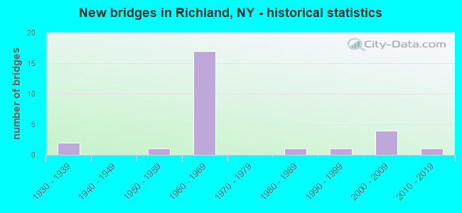
- New bridges - historical statistics
- 21930-1939
- 11950-1959
- 171960-1969
- 11980-1989
- 11990-1999
- 42000-2009
- 12010-2019

- Reconstructed bridges - Historical Statistics
- 21980-1989
- 01990-1999
- 22000-2009


- Bridge Condition - Deck
- 11.8%Very good
- 35.3%Good
- 47.1%Satisfactory
- 5.9%Fair

- Bridge Condition - Superstructure
- 22.2%Very good
- 22.2%Good
- 33.3%Satisfactory
- 22.2%Fair

- Bridge Condition - Substructure
- 16.7%Very good
- 33.3%Good
- 22.2%Satisfactory
- 16.7%Fair
- 11.1%Poor

- Bridge Condition - Channel
- 27.3%Very good
- 27.3%Good
- 45.5%Satisfactory
Find on map >> Show street view
Structure Number: 100035, Location: 2.9 MI SW JCT RTS 3 + 13 (Lat: 43.529769, Lng: -76.205550), Route carried "on" structure: State highway 3, Year Built: 1934, Status: Open, Structure Length: 0.73m (2.40ft), Average Daily Traffic: 3,783 (year 2018), Truck Traffic: 10%, Average Future Daily Traffic: 3,806 (year 2040), Features Intersected: SNAKE CREEK
Minimum Vertical Clearance: 30+ m (98+ ft), Kilometerpoint: 51.665, Lanes on structure: 2, Base Highway Network: Yes, Owner: State Highway Agency, Approaching Roadway Width: 9.8m (32.2ft), Material/Design: Concrete, Design/Construction: Arch - Deck, Number Of Spans In Main Unit: 1, Length of Maximum Span: 6.7m (22.0ft), Curb-To-Curb Width: 9.8m (32.2ft), Out-to-Out Width: 16.9m (55.4ft)
Condition: Superstructure: Satisfactory, Substructure: Satisfactory, Channel: Good, Operating Rating: 74.5 metric tons, Method Used To Determine Operating Rating: Field evaluation and documented engineering judgment, Inventory Rating: 32.7 metric tons, Method Used To Determine Inventory Rating: Field evaluation and documented engineering judgment, Structural Evaluation: Equal to present minimum criteria, Deck Geometry: Meets minimum limits, Waterway Adequacy: Somewhat better than minimum adequacy, Approach Roadway Alignment: Equal to present desirable criteria, Length Of Structure Improvement: 0.73m (2.40ft), Designated Inspection Frequency: Every 24 months, Inspection Date: September 2020, Bridge Improvement Cost: $299,000, Roadway Improvement Cost: $175,000, Total Project Cost: $474,000 ( Estimate for 2021), Wearing Surface/Protective System: Wearing Surface: Bituminous
Find on map >> Show street view
Structure Number: 100036, Location: 1.7 MI S JCT RTS 3 & 13 (Lat: 43.542797, Lng: -76.192353), Route carried "on" structure: State highway 3, Year Built: 1994, Status: Open, Structure Length: 3.11m (10.20ft), Average Daily Traffic: 3,783 (year 2018), Truck Traffic: 10%, Average Future Daily Traffic: 3,806 (year 2040), Design Load: HS 25 or greater, Features Intersected: GRINDSTONE CREEK
Minimum Vertical Clearance: 30+ m (98+ ft), Kilometerpoint: 53.467, Lanes on structure: 2, Base Highway Network: Yes, Owner: State Highway Agency, Approaching Roadway Width: 11.0m (36.1ft), Material/Design: Steel, Design/Construction: Stringer/Multi-beam, Number Of Spans In Main Unit: 1, Length of Maximum Span: 30.4m (99.7ft), Curb-To-Curb Width: 11.0m (36.1ft), Out-to-Out Width: 11.6m (38.1ft)
Condition: Deck: Very good, Superstructure: Very good, Substructure: Very good, Channel: Good, Operating Rating: 63.8 metric tons, Method Used To Determine Operating Rating: Load and Resistance Factor Rating (LRFR) rating reported by rating factor(RF) method using HL-93 loadings, Inventory Rating: 49.2 metric tons, Method Used To Determine Inventory Rating: Load and Resistance Factor Rating (LRFR) rating reported by rating factor(RF) method using HL-93 loadings, Structural Evaluation: Equal to present desirable criteria, Deck Geometry: Somewhat better than minimum adequacy, Waterway Adequacy: Equal to present desirable criteria, Approach Roadway Alignment: Equal to present desirable criteria, Length Of Structure Improvement: 3.10m (10.17ft), Designated Inspection Frequency: Every 24 months, Inspection Date: March 2020, Bridge Improvement Cost: $780,000, Roadway Improvement Cost: $457,000, Total Project Cost: $1,237,000 ( Estimate for 2021), Deck Structure Type: Concrete Cast-file-Place, Wearing Surface/Protective System: Wearing Surface: Integral Concrete, Deck Protection: Epoxy Coated Reinforcing
Find on map >> Show street view
Structure Number: 100037, Location: .1 MI N JCT SH 3 & SH 13 (Lat: 43.567856, Lng: -76.187322), Route carried "on" structure: State highway 3, Year Built: 2000, Status: Open, Structure Length: 10.64m (34.91ft), Average Daily Traffic: 1,940 (year 2018), Truck Traffic: 14%, Average Future Daily Traffic: 1,952 (year 2040), Design Load: HS 25 or greater, Features Intersected: SALMON RIVER
Minimum Vertical Clearance: 30+ m (98+ ft), Kilometerpoint: 56.251, Lanes on structure: 3, Base Highway Network: Yes, Owner: State Highway Agency, Approaching Roadway Width: 12.5m (41.0ft), Material/Design: Steel continuous, Design/Construction: Stringer/Multi-beam, Number Of Spans In Main Unit: 3, Length of Maximum Span: 45.1m (148.0ft), Curb or Sidewalk Widths: Left: 1.5m (4.9ft), Right: 1.5m (4.9ft), Curb-To-Curb Width: 12.5m (41.0ft), Out-to-Out Width: 16.6m (54.5ft)
Condition: Deck: Good, Superstructure: Good, Substructure: Good, Channel: Satisfactory, Operating Rating: 46.7 metric tons, Method Used To Determine Operating Rating: Load and Resistance Factor Rating (LRFR) rating reported by rating factor(RF) method using HL-93 loadings, Inventory Rating: 36.0 metric tons, Method Used To Determine Inventory Rating: Load and Resistance Factor Rating (LRFR) rating reported by rating factor(RF) method using HL-93 loadings, Structural Evaluation: Better than present minimum criteria, Deck Geometry: Meets minimum limits, Waterway Adequacy: Superior to present desirable criteria, Approach Roadway Alignment: Equal to present desirable criteria, Length Of Structure Improvement: 10.63m (34.88ft), Designated Inspection Frequency: Every 24 months, Underwater Inspection Frequency: Every 60 months, Inspection Date: June 2020, Underwater Inspection Date: June 2020, Bridge Improvement Cost: $3,604,000, Roadway Improvement Cost: $2,110,000, Total Project Cost: $5,714,000 ( Estimate for 2021), Deck Structure Type: Concrete Cast-file-Place, Wearing Surface/Protective System: Wearing Surface: Monolithic Concrete, Deck Protection: Epoxy Coated Reinforcing
Find on map >> Show street view
Structure Number: 100038, Location: .2 MI N JCT SH 3 & SH 13 (Lat: 43.569683, Lng: -76.186953), Route carried "on" structure: State highway 3, Year Built: 2000, Status: Open, Structure Length: 10.64m (34.91ft), Average Daily Traffic: 1,940 (year 2018), Truck Traffic: 14%, Average Future Daily Traffic: 1,952 (year 2040), Design Load: HS 25 or greater, Features Intersected: SALMON RIVER
Minimum Vertical Clearance: 30+ m (98+ ft), Kilometerpoint: 56.524, Lanes on structure: 2, Base Highway Network: Yes, Owner: State Highway Agency, Approaching Roadway Width: 9.1m (29.9ft), Material/Design: Steel continuous, Design/Construction: Stringer/Multi-beam, Number Of Spans In Main Unit: 3, Length of Maximum Span: 45.1m (148.0ft), Curb or Sidewalk Widths: Left: 1.5m (4.9ft), Right: 1.5m (4.9ft), Curb-To-Curb Width: 9.1m (29.9ft), Out-to-Out Width: 13.2m (43.3ft)
Condition: Deck: Good, Superstructure: Good, Substructure: Good, Channel: Very good, Operating Rating: 68.9 metric tons, Method Used To Determine Operating Rating: Load Factor (LF), Inventory Rating: 41.7 metric tons, Method Used To Determine Inventory Rating: Load Factor (LF), Structural Evaluation: Better than present minimum criteria, Deck Geometry: Somewhat better than minimum adequacy, Waterway Adequacy: Superior to present desirable criteria, Approach Roadway Alignment: Equal to present desirable criteria, Length Of Structure Improvement: 10.63m (34.88ft), Designated Inspection Frequency: Every 24 months, Underwater Inspection Frequency: Every 60 months, Inspection Date: June 2020, Underwater Inspection Date: June 2019, Bridge Improvement Cost: $2,859,000, Roadway Improvement Cost: $1,674,000, Total Project Cost: $4,534,000 ( Estimate for 2021), Deck Structure Type: Concrete Cast-file-Place, Wearing Surface/Protective System: Wearing Surface: Monolithic Concrete, Deck Protection: Epoxy Coated Reinforcing
Find on map >> Show street view
Structure Number: 100039, Location: 1.9 MI NE JCT SH 3 & SH13 (Lat: 43.590286, Lng: -76.171281), Route carried "on" structure: State highway 3, Year Built: 2002, Status: Open, Structure Length: 2.41m (7.91ft), Average Daily Traffic: 1,940 (year 2018), Truck Traffic: 14%, Average Future Daily Traffic: 1,952 (year 2040), Design Load: HS 25 or greater, Features Intersected: DEER CREEK
Minimum Vertical Clearance: 30+ m (98+ ft), Kilometerpoint: 59.163, Lanes on structure: 2, Base Highway Network: Yes, Owner: State Highway Agency, Approaching Roadway Width: 10.4m (34.1ft), Material/Design: Prestressed concrete, Design/Construction: Box Beam or Girders - Multiple, Number Of Spans In Main Unit: 1, Length of Maximum Span: 23.6m (77.4ft), Curb-To-Curb Width: 10.3m (33.8ft), Out-to-Out Width: 11.3m (37.1ft)
Condition: Deck: Satisfactory, Superstructure: Very good, Substructure: Very good, Channel: Very good, Operating Rating: 84.2 metric tons, Method Used To Determine Operating Rating: Load and Resistance Factor Rating (LRFR) rating reported by rating factor(RF) method using HL-93 loadings, Inventory Rating: 64.8 metric tons, Method Used To Determine Inventory Rating: Load and Resistance Factor Rating (LRFR) rating reported by rating factor(RF) method using HL-93 loadings, Structural Evaluation: Equal to present desirable criteria, Deck Geometry: Somewhat better than minimum adequacy, Waterway Adequacy: Equal to present desirable criteria, Approach Roadway Alignment: Equal to present desirable criteria, Length Of Structure Improvement: 2.40m (7.87ft), Designated Inspection Frequency: Every 24 months, Inspection Date: August 2020, Bridge Improvement Cost: $880,000, Roadway Improvement Cost: $515,000, Total Project Cost: $1,395,000 ( Estimate for 2021), Deck Structure Type: Concrete Cast-file-Place, Wearing Surface/Protective System: Wearing Surface: Monolithic Concrete
Find on map >> Show street view
Structure Number: 103186, Location: 2.3 MI N EXIT 34 OF I81 (Lat: 43.492489, Lng: -76.119536), Route carried "on" structure: Other road , Year Built: 1961, Status: Open, Structure Length: 3.90m (12.80ft), Average Daily Traffic: 121 (year 2016), Truck Traffic: 8%, Average Future Daily Traffic: 169 (year 2036), Design Load: HS 20, Features Intersected: RTE I81, Facility Carried by Structure: FRANK LACY ROAD
Minimum Vertical Clearance: 30+ m (98+ ft), Kilometerpoint: 0.981, Lanes on structure: 2, Lanes under structure: 2, Owner: State Highway Agency, Approaching Roadway Width: 5.5m (18.0ft), Skew: 1 degrees, Material/Design: Steel, Design/Construction: Stringer/Multi-beam, Number Of Spans In Main Unit: 3, Length of Maximum Span: 13.4m (44.0ft), Curb or Sidewalk Widths: Left: 0.5m (1.6ft), Right: 0.5m (1.6ft), Curb-To-Curb Width: 9.1m (29.9ft), Out-to-Out Width: 10.7m (35.1ft)
Condition: Deck: Satisfactory, Superstructure: Satisfactory, Substructure: Fair, Operating Rating: 24.3 metric tons, Method Used To Determine Operating Rating: Load and Resistance Factor Rating (LRFR) rating reported by rating factor(RF) method using HL-93 loadings, Inventory Rating: 18.8 metric tons, Method Used To Determine Inventory Rating: Load and Resistance Factor Rating (LRFR) rating reported by rating factor(RF) method using HL-93 loadings, Structural Evaluation: Somewhat better than minimum adequacy, Deck Geometry: Equal to present minimum criteria, Underclear: High priority of corrective action, Approach Roadway Alignment: Equal to present desirable criteria, Length Of Structure Improvement: 3.90m (12.80ft), Designated Inspection Frequency: Every 24 months, Inspection Date: May 2020, Bridge Improvement Cost: $880,000, Roadway Improvement Cost: $515,000, Total Project Cost: $1,395,000 ( Estimate for 2021), Deck Structure Type: Concrete Cast-file-Place, Wearing Surface/Protective System: Wearing Surface: Bituminous, Membrane: Preformed Fabric
Find on map >> Show street view
Structure Number: 1031871, Location: EXIT 35 OF I81 (Lat: 43.506839, Lng: -76.121658), Route carried "on" structure: Interstate 81, Year Built: 1961, Status: Open, Structure Length: 3.90m (12.80ft), Average Daily Traffic: 8,753 (year 2003), Truck Traffic: 18%, Design Load: HS 20, Features Intersected: COUNTY ROAD 28
Minimum Vertical Clearance: 30+ m (98+ ft), Kilometerpoint: 30.555, Lanes on structure: 2, Lanes under structure: 2, Base Highway Network: Yes, Owner: State Highway Agency, Approaching Roadway Width: 9.1m (29.9ft), Material/Design: Steel, Design/Construction: Stringer/Multi-beam, Number Of Spans In Main Unit: 3, Length of Maximum Span: 14.0m (45.9ft), Curb-To-Curb Width: 9.1m (29.9ft), Out-to-Out Width: 10.7m (35.1ft)
Condition: Deck: Satisfactory, Superstructure: Fair, Substructure: Satisfactory, Operating Rating: 23.7 metric tons, Method Used To Determine Operating Rating: Load and Resistance Factor Rating (LRFR) rating reported by rating factor(RF) method using HL-93 loadings, Inventory Rating: 18.1 metric tons, Method Used To Determine Inventory Rating: Load and Resistance Factor Rating (LRFR) rating reported by rating factor(RF) method using HL-93 loadings, Structural Evaluation: Meets minimum limits, Deck Geometry: High priority of replacement, Underclear: Somewhat better than minimum adequacy, Approach Roadway Alignment: Equal to present desirable criteria, Length Of Structure Improvement: 3.90m (12.80ft), Designated Inspection Frequency: Every 24 months, Inspection Date: November 2020, Bridge Improvement Cost: $876,000, Roadway Improvement Cost: $513,000, Total Project Cost: $1,388,000 ( Estimate for 2021), Deck Structure Type: Concrete Cast-file-Place, Wearing Surface/Protective System: Wearing Surface: Bituminous
Find on map >> Show street view
Structure Number: 1031872, Location: EXIT 35 OF I81 (Lat: 43.506869, Lng: -76.121019), Route carried "on" structure: Interstate 81, Year Built: 1961, Status: Open, Structure Length: 3.90m (12.80ft), Average Daily Traffic: 6,547 (year 2020), Truck Traffic: 25%, Average Future Daily Traffic: 7,339 (year 2040), Design Load: HS 20, Features Intersected: COUNTY ROAD 28
Minimum Vertical Clearance: 30+ m (98+ ft), Kilometerpoint: 30.555, Lanes on structure: 2, Lanes under structure: 2, Base Highway Network: Yes, Owner: State Highway Agency, Approaching Roadway Width: 13.7m (44.9ft), Material/Design: Steel, Design/Construction: Stringer/Multi-beam, Number Of Spans In Main Unit: 3, Length of Maximum Span: 14.0m (45.9ft), Curb-To-Curb Width: 9.1m (29.9ft), Out-to-Out Width: 10.7m (35.1ft)
Condition: Deck: Satisfactory, Superstructure: Fair, Substructure: Satisfactory, Operating Rating: 64.4 metric tons, Method Used To Determine Operating Rating: Load Factor (LF), Inventory Rating: 38.1 metric tons, Method Used To Determine Inventory Rating: Load Factor (LF), Structural Evaluation: Somewhat better than minimum adequacy, Deck Geometry: High priority of replacement, Underclear: Somewhat better than minimum adequacy, Approach Roadway Alignment: Equal to present desirable criteria, Length Of Structure Improvement: 3.90m (12.80ft), Designated Inspection Frequency: Every 24 months, Inspection Date: November 2020, Bridge Improvement Cost: $876,000, Roadway Improvement Cost: $513,000, Total Project Cost: $1,388,000 ( Estimate for 2021), Deck Structure Type: Concrete Cast-file-Place, Wearing Surface/Protective System: Wearing Surface: Bituminous
Find on map >> Show street view
Structure Number: 1031881, Location: 1 MI S I81 SB & SH 13 (Lat: 43.538214, Lng: -76.117089), Route carried "on" structure: Interstate 81, Year Built: 1961, Year Reconstructed: 1991, Status: Open, Structure Length: 3.90m (12.80ft), Average Daily Traffic: 8,174 (year 2008), Truck Traffic: 24%, Design Load: HS 20, Features Intersected: HALSEY ROAD
Minimum Vertical Clearance: 30+ m (98+ ft), Kilometerpoint: 34.063, Lanes on structure: 2, Lanes under structure: 2, Base Highway Network: Yes, Owner: State Highway Agency, Approaching Roadway Width: 12.2m (40.0ft), Material/Design: Steel, Design/Construction: Stringer/Multi-beam, Number Of Spans In Main Unit: 3, Length of Maximum Span: 14.3m (46.9ft), Curb-To-Curb Width: 12.0m (39.4ft), Out-to-Out Width: 13.0m (42.7ft)
Condition: Deck: Good, Superstructure: Satisfactory, Substructure: Good, Operating Rating: 57.2 metric tons, Method Used To Determine Operating Rating: Load Factor (LF), Inventory Rating: 32.7 metric tons, Method Used To Determine Inventory Rating: Load Factor (LF), Structural Evaluation: Equal to present minimum criteria, Deck Geometry: Equal to present minimum criteria, Underclear: High priority of corrective action, Approach Roadway Alignment: Equal to present desirable criteria, Length Of Structure Improvement: 3.90m (12.80ft), Designated Inspection Frequency: Every 24 months, Inspection Date: September 2020, Bridge Improvement Cost: $1,103,000, Roadway Improvement Cost: $646,000, Total Project Cost: $1,750,000 ( Estimate for 2021), Deck Structure Type: Concrete Cast-file-Place, Wearing Surface/Protective System: Wearing Surface: Epoxy Overlay, Deck Protection: Epoxy Coated Reinforcing
Find on map >> Show street view
Structure Number: 1031882, Location: 1 MI S I81 NB & SH 13 (Lat: 43.537917, Lng: -76.115897), Route carried "on" structure: Interstate 81, Year Built: 1961, Year Reconstructed: 1991, Status: Open, Structure Length: 3.90m (12.80ft), Average Daily Traffic: 7,339 (year 2019), Truck Traffic: 15%, Average Future Daily Traffic: 8,226 (year 2040), Design Load: HS 20, Features Intersected: HALSEY ROAD
Minimum Vertical Clearance: 30+ m (98+ ft), Kilometerpoint: 34.063, Lanes on structure: 2, Lanes under structure: 2, Base Highway Network: Yes, Owner: State Highway Agency, Approaching Roadway Width: 12.2m (40.0ft), Material/Design: Steel, Design/Construction: Stringer/Multi-beam, Number Of Spans In Main Unit: 3, Length of Maximum Span: 14.0m (45.9ft), Curb-To-Curb Width: 12.0m (39.4ft), Out-to-Out Width: 13.0m (42.7ft)
Condition: Deck: Good, Superstructure: Fair, Substructure: Good, Operating Rating: 63.5 metric tons, Method Used To Determine Operating Rating: Load Factor (LF), Inventory Rating: 38.1 metric tons, Method Used To Determine Inventory Rating: Load Factor (LF), Structural Evaluation: Somewhat better than minimum adequacy, Deck Geometry: Equal to present minimum criteria, Underclear: High priority of corrective action, Approach Roadway Alignment: Equal to present desirable criteria, Length Of Structure Improvement: 3.90m (12.80ft), Designated Inspection Frequency: Every 24 months, Inspection Date: September 2020, Bridge Improvement Cost: $1,109,000, Roadway Improvement Cost: $649,000, Total Project Cost: $1,758,000 ( Estimate for 2021), Deck Structure Type: Concrete Cast-file-Place, Wearing Surface/Protective System: Wearing Surface: Epoxy Overlay, Deck Protection: Epoxy Coated Reinforcing
Find on map >> Show street view
Structure Number: 103192, Location: 2 MI N JCT EXIT 36 OF I81 (Lat: 43.586225, Lng: -76.107581), Route carried "on" structure: Other road , Year Built: 1961, Status: Open, Structure Length: 4.27m (14.01ft), Average Daily Traffic: 423 (year 2017), Truck Traffic: 8%, Average Future Daily Traffic: 592 (year 2037), Design Load: HS 20, Features Intersected: RTE I81, Facility Carried by Structure: CANNING FACTRY RD
Minimum Vertical Clearance: 30+ m (98+ ft), Kilometerpoint: 0.563, Lanes on structure: 2, Lanes under structure: 2, Owner: State Highway Agency, Approaching Roadway Width: 5.5m (18.0ft), Skew: 2 degrees, Material/Design: Steel, Design/Construction: Stringer/Multi-beam, Number Of Spans In Main Unit: 3, Length of Maximum Span: 14.3m (46.9ft), Curb or Sidewalk Widths: Left: 0.5m (1.6ft), Right: 0.5m (1.6ft), Curb-To-Curb Width: 9.1m (29.9ft), Out-to-Out Width: 10.7m (35.1ft)
Condition: Deck: Satisfactory, Superstructure: Good, Substructure: Fair, Operating Rating: 28.2 metric tons, Method Used To Determine Operating Rating: Load and Resistance Factor Rating (LRFR) rating reported by rating factor(RF) method using HL-93 loadings, Inventory Rating: 21.7 metric tons, Method Used To Determine Inventory Rating: Load and Resistance Factor Rating (LRFR) rating reported by rating factor(RF) method using HL-93 loadings, Structural Evaluation: Somewhat better than minimum adequacy, Deck Geometry: Equal to present minimum criteria, Underclear: High priority of corrective action, Approach Roadway Alignment: Equal to present desirable criteria, Length Of Structure Improvement: 4.26m (13.98ft), Designated Inspection Frequency: Every 24 months, Inspection Date: June 2020, Bridge Improvement Cost: $974,000, Roadway Improvement Cost: $570,000, Total Project Cost: $1,544,000 ( Estimate for 2021), Deck Structure Type: Concrete Cast-file-Place, Wearing Surface/Protective System: Wearing Surface: Bituminous
Find on map >> Show street view
Structure Number: 106477, Location: 2.3 MI N EXIT 34 OF I81 (Lat: 43.492939, Lng: -76.121392), Route carried "on" structure: Other road , Year Built: 1961, Status: Open, Structure Length: 3.87m (12.70ft), Average Daily Traffic: 121 (year 2016), Truck Traffic: 8%, Average Future Daily Traffic: 169 (year 2036), Design Load: HS 20, Features Intersected: RTE I81, Facility Carried by Structure: FRANK LACY ROAD
Minimum Vertical Clearance: 30+ m (98+ ft), Kilometerpoint: 0.821, Lanes on structure: 2, Lanes under structure: 2, Owner: State Highway Agency, Approaching Roadway Width: 5.5m (18.0ft), Skew: 1 degrees, Material/Design: Steel, Design/Construction: Stringer/Multi-beam, Number Of Spans In Main Unit: 3, Length of Maximum Span: 13.4m (44.0ft), Curb or Sidewalk Widths: Left: 0.5m (1.6ft), Right: 0.5m (1.6ft), Curb-To-Curb Width: 9.1m (29.9ft), Out-to-Out Width: 10.7m (35.1ft)
Condition: Deck: Satisfactory, Superstructure: Satisfactory, Substructure: Fair, Operating Rating: 55.3 metric tons, Method Used To Determine Operating Rating: Load Factor (LF), Inventory Rating: 32.7 metric tons, Method Used To Determine Inventory Rating: Load Factor (LF), Structural Evaluation: Somewhat better than minimum adequacy, Deck Geometry: Equal to present minimum criteria, Underclear: High priority of corrective action, Approach Roadway Alignment: Equal to present desirable criteria, Length Of Structure Improvement: 3.87m (12.70ft), Designated Inspection Frequency: Every 24 months, Inspection Date: May 2020, Bridge Improvement Cost: $875,000, Roadway Improvement Cost: $512,000, Total Project Cost: $1,387,000 ( Estimate for 2021), Deck Structure Type: Concrete Cast-file-Place, Wearing Surface/Protective System: Wearing Surface: Bituminous, Membrane: Preformed Fabric
Find on map >> Show street view
Structure Number: 106478, Location: 2 MI N EXIT 36 OF I81 (Lat: 43.586144, Lng: -76.109042), Route carried "on" structure: Other road , Year Built: 1961, Status: Open, Structure Length: 4.21m (13.81ft), Average Daily Traffic: 423 (year 2017), Truck Traffic: 8%, Average Future Daily Traffic: 592 (year 2037), Design Load: HS 20, Features Intersected: RTE I81, Facility Carried by Structure: CANNING FACTRY RD
Minimum Vertical Clearance: 30+ m (98+ ft), Kilometerpoint: 0.434, Lanes on structure: 2, Lanes under structure: 2, Owner: State Highway Agency, Approaching Roadway Width: 5.5m (18.0ft), Skew: 2 degrees, Material/Design: Steel, Design/Construction: Stringer/Multi-beam, Number Of Spans In Main Unit: 3, Length of Maximum Span: 14.3m (46.9ft), Curb or Sidewalk Widths: Left: 0.5m (1.6ft), Right: 0.5m (1.6ft), Curb-To-Curb Width: 9.1m (29.9ft), Out-to-Out Width: 10.7m (35.1ft)
Condition: Deck: Satisfactory, Superstructure: Satisfactory, Substructure: Satisfactory, Operating Rating: 34.5 metric tons, Method Used To Determine Operating Rating: Load Factor (LF), Inventory Rating: 20.9 metric tons, Method Used To Determine Inventory Rating: Load Factor (LF), Structural Evaluation: Equal to present minimum criteria, Deck Geometry: Equal to present minimum criteria, Underclear: High priority of corrective action, Approach Roadway Alignment: Equal to present desirable criteria, Length Of Structure Improvement: 4.20m (13.78ft), Designated Inspection Frequency: Every 24 months, Inspection Date: June 2020, Bridge Improvement Cost: $948,000, Roadway Improvement Cost: $555,000, Total Project Cost: $1,503,000 ( Estimate for 2021), Deck Structure Type: Concrete Cast-file-Place, Wearing Surface/Protective System: Wearing Surface: Bituminous
Find on map >> Show street view
Structure Number: 331375, Location: 3.7 MI. SW. OF PULASKI (Lat: 43.526939, Lng: -76.176581), Route carried "on" structure: County highway , Year Built: 1985, Year Reconstructed: 2012, Status: Open, Structure Length: 1.22m (4.00ft), Average Daily Traffic: 389 (year 2018), Truck Traffic: 8%, Average Future Daily Traffic: 545 (year 2038), Features Intersected: GRINDSTONE CREEK, Facility Carried by Structure: SALISBURY ROAD
Minimum Vertical Clearance: 30+ m (98+ ft), Kilometerpoint: 2.204, Lanes on structure: 2, Owner: County Highway Agency, Approaching Roadway Width: 8.8m (28.9ft), Material/Design: Steel, Design/Construction: Stringer/Multi-beam, Number Of Spans In Main Unit: 1, Length of Maximum Span: 11.8m (38.7ft), Curb-To-Curb Width: 8.8m (28.9ft), Out-to-Out Width: 9.1m (29.9ft)
Condition: Deck: Satisfactory, Superstructure: Good, Substructure: Poor, Channel: Satisfactory, Operating Rating: 92.5 metric tons, Method Used To Determine Operating Rating: Allowable Stress (AS), Inventory Rating: 64.4 metric tons, Method Used To Determine Inventory Rating: Allowable Stress (AS), Structural Evaluation: Meets minimum limits, Deck Geometry: Equal to present minimum criteria, Waterway Adequacy: Somewhat better than minimum adequacy, Approach Roadway Alignment: Equal to present desirable criteria, Length Of Structure Improvement: 1.21m (3.97ft), Designated Inspection Frequency: Every 24 months, Inspection Date: December 2021, Bridge Improvement Cost: $393,000, Roadway Improvement Cost: $230,000, Total Project Cost: $623,000 ( Estimate for 2021), Deck Structure Type: Corrugated Steel, Wearing Surface/Protective System: Wearing Surface: Bituminous
Find on map >> Show street view
Structure Number: 331376, Location: 4.5 MI NW OF ALTMAR (Lat: 43.570833, Lng: -76.034333), Route carried "on" structure: County highway , Year Built: 1930, Status: Open, Structure Length: 1.13m (3.71ft), Average Daily Traffic: 1,262 (year 2017), Truck Traffic: 6%, Average Future Daily Traffic: 1,767 (year 2037), Features Intersected: TROUT BROOK, Facility Carried by Structure: RICHLAND-ORWELL RO
Minimum Vertical Clearance: 30+ m (98+ ft), Kilometerpoint: 7.611, Lanes on structure: 2, Owner: County Highway Agency, Approaching Roadway Width: 6.7m (22.0ft), Material/Design: Steel, Design/Construction: Stringer/Multi-beam, Number Of Spans In Main Unit: 1, Length of Maximum Span: 11.0m (36.1ft), Curb-To-Curb Width: 9.0m (29.5ft), Out-to-Out Width: 9.6m (31.5ft)
Condition: Deck: Fair, Superstructure: Fair, Substructure: Poor, Channel: Satisfactory, Operating Rating: 94.3 metric tons, Method Used To Determine Operating Rating: Allowable Stress (AS), Inventory Rating: 66.2 metric tons, Method Used To Determine Inventory Rating: Allowable Stress (AS), Structural Evaluation: Meets minimum limits, Deck Geometry: Somewhat better than minimum adequacy, Waterway Adequacy: Somewhat better than minimum adequacy, Approach Roadway Alignment: Equal to present desirable criteria, Length Of Structure Improvement: 1.12m (3.67ft), Designated Inspection Frequency: Every 24 months, Inspection Date: September 2021, Bridge Improvement Cost: $366,000, Roadway Improvement Cost: $215,000, Total Project Cost: $581,000 ( Estimate for 2021), Deck Structure Type: Corrugated Steel, Wearing Surface/Protective System: Wearing Surface: Bituminous
Find on map >> Show street view
Structure Number: 331387, Location: 4 MI SW OF PULASKI (Lat: 43.513183, Lng: -76.162881), Route carried "on" structure: County highway , Year Built: 2008, Status: Open, Structure Length: 1.16m (3.81ft), Average Daily Traffic: 736 (year 2016), Truck Traffic: 5%, Average Future Daily Traffic: 1,030 (year 2036), Features Intersected: GRINDSTONE CREEK, Facility Carried by Structure: CR 41
Minimum Vertical Clearance: 30+ m (98+ ft), Kilometerpoint: 9.107, Lanes on structure: 2, Owner: County Highway Agency, Approaching Roadway Width: 9.1m (29.9ft), Material/Design: Steel, Design/Construction: Stringer/Multi-beam, Number Of Spans In Main Unit: 1, Length of Maximum Span: 11.3m (37.1ft), Curb-To-Curb Width: 9.0m (29.5ft), Out-to-Out Width: 9.1m (29.9ft)
Condition: Deck: Good, Superstructure: Satisfactory, Substructure: Good, Channel: Satisfactory, Operating Rating: 98.9 metric tons, Method Used To Determine Operating Rating: Allowable Stress (AS), Inventory Rating: 67.1 metric tons, Method Used To Determine Inventory Rating: Allowable Stress (AS), Structural Evaluation: Equal to present minimum criteria, Deck Geometry: Somewhat better than minimum adequacy, Waterway Adequacy: Meets minimum limits, Approach Roadway Alignment: Equal to present desirable criteria, Length Of Structure Improvement: 1.15m (3.77ft), Designated Inspection Frequency: Every 24 months, Inspection Date: November 2020, Bridge Improvement Cost: $393,000, Roadway Improvement Cost: $230,000, Total Project Cost: $623,000 ( Estimate for 2021), Deck Structure Type: Corrugated Steel, Wearing Surface/Protective System: Wearing Surface: Bituminous
Find on map >> Show street view
Structure Number: 331388, Location: 4.8 MI SW OF PULASKI (Lat: 43.495286, Lng: -76.150628), Route carried "on" structure: County highway , Year Built: 2017, Status: Open, Structure Length: 2.20m (7.22ft), Average Daily Traffic: 308 (year 2020), Truck Traffic: 8%, Average Future Daily Traffic: 431 (year 2040), Design Load: HL 93, Features Intersected: GRINDSTONE CREEK, Facility Carried by Structure: COUNTY ROAD 41A
Minimum Vertical Clearance: 32.69m (107.25ft), Kilometerpoint: 1.850, Lanes on structure: 2, Owner: County Highway Agency, Approaching Roadway Width: 9.8m (32.2ft), Skew: 1 degrees, Material/Design: Prestressed concrete, Design/Construction: Box Beam or Girders - Multiple, Number Of Spans In Main Unit: 1, Length of Maximum Span: 21.0m (68.9ft), Curb-To-Curb Width: 9.8m (32.2ft), Out-to-Out Width: 10.8m (35.4ft)
Condition: Deck: Good, Superstructure: Very good, Substructure: Very good, Channel: Very good, Operating Rating: 66.2 metric tons, Method Used To Determine Operating Rating: Load Factor (LF), Inventory Rating: 39.9 metric tons, Method Used To Determine Inventory Rating: Load Factor (LF), Structural Evaluation: Equal to present desirable criteria, Deck Geometry: Better than present minimum criteria, Waterway Adequacy: Meets minimum limits, Approach Roadway Alignment: Equal to present desirable criteria, Length Of Structure Improvement: 2.20m (7.22ft), Designated Inspection Frequency: Every 24 months, Inspection Date: May 2020, Bridge Improvement Cost: $676,000, Roadway Improvement Cost: $396,000, Total Project Cost: $1,072,000 ( Estimate for 2021), Deck Structure Type: Other, Wearing Surface/Protective System: Wearing Surface: Monolithic Concrete
Find on map >> Show street view
Structure Number: 335823, Location: 1.9 MI SE OF PULASKI (Lat: 43.550067, Lng: -76.093867), Route carried "on" structure: County highway , Year Built: 1966, Year Reconstructed: 2014, Status: Open, Structure Length: 6.61m (21.69ft), Average Daily Traffic: 2,982 (year 2020), Truck Traffic: 13%, Average Future Daily Traffic: 4,169 (year 2040), Design Load: HL 93, Features Intersected: SALMON RIVER, Facility Carried by Structure: LEHIGH ROAD
Minimum Vertical Clearance: 30+ m (98+ ft), Kilometerpoint: 0.563, Lanes on structure: 2, Owner: County Highway Agency, Approaching Roadway Width: 12.2m (40.0ft), Material/Design: Prestressed concrete, Design/Construction: Box Beam or Girders - Multiple, Number Of Spans In Main Unit: 3, Length of Maximum Span: 21.3m (69.9ft), Curb-To-Curb Width: 9.1m (29.9ft), Out-to-Out Width: 10.2m (33.5ft)
Condition: Deck: Very good, Superstructure: Very good, Substructure: Good, Channel: Satisfactory, Operating Rating: 95.3 metric tons, Method Used To Determine Operating Rating: Load Factor (LF), Inventory Rating: 57.2 metric tons, Method Used To Determine Inventory Rating: Load Factor (LF), Structural Evaluation: Better than present minimum criteria, Deck Geometry: Meets minimum limits, Waterway Adequacy: Equal to present minimum criteria, Approach Roadway Alignment: Equal to present desirable criteria, Length Of Structure Improvement: 6.61m (21.69ft), Designated Inspection Frequency: Every 24 months, Inspection Date: September 2021, Bridge Improvement Cost: $1,784,000, Roadway Improvement Cost: $1,045,000, Total Project Cost: $2,829,000 ( Estimate for 2021), Wearing Surface/Protective System: Wearing Surface: Monolithic Concrete
Find on map >> Show street view
Structure Number: 336583, Location: 2.2 MI NW OF PULASKI (Lat: 43.584753, Lng: -76.158831), Route carried "on" structure: Other road , Year Built: 1950, Status: Open, Structure Length: 0.79m (2.59ft), Average Daily Traffic: 257 (year 2020), Truck Traffic: 8%, Average Future Daily Traffic: 360 (year 2040), Features Intersected: LITTLE DEER CREEK, Facility Carried by Structure: CLARK ROAD
Minimum Vertical Clearance: 30+ m (98+ ft), Kilometerpoint: 2.043, Lanes on structure: 2, Owner: Town or Township Highway Agency, Approaching Roadway Width: 5.5m (18.0ft), Material/Design: Steel, Design/Construction: Culvert, Number Of Spans In Main Unit: 1, Length of Maximum Span: 7.0m (23.0ft)
Condition: Channel: Good, Culverts: Fair, Operating Rating: 72.8 metric tons, Method Used To Determine Operating Rating: Field evaluation and documented engineering judgment, Inventory Rating: 19.6 metric tons, Method Used To Determine Inventory Rating: Field evaluation and documented engineering judgment, Structural Evaluation: Somewhat better than minimum adequacy, Waterway Adequacy: Meets minimum limits, Approach Roadway Alignment: Equal to present desirable criteria, Length Of Structure Improvement: 0.79m (2.59ft), Designated Inspection Frequency: Every 24 months, Inspection Date: November 2020, Bridge Improvement Cost: $101,000, Roadway Improvement Cost: $59,000, Total Project Cost: $160,000 ( Estimate for 2021)
Find on map >> Show street view
Structure Number: 103186, Location: 2.3 MI N EXIT 34 OF I81 (Lat: 43.492489, Lng: -76.119536), Route carried "under" structure: Interstate 81, Year Built: 1961, Structure Length: 0. m, Average Daily Traffic: 19,426 (year 2000), Features Intersected: RTE I81, Facility Carried by Structure: FRANK LACY ROAD
Minimum Vertical Clearance: 5.25m (17.22ft), Kilometerpoint: 29.139, Lanes on structure: 2, Lanes under structure: 2, Material/Design: Steel, Design/Construction: Stringer/Multi-beam, Length of Maximum Span: 13.4m (44.0ft)
Find on map >> Show street view
Structure Number: 1031871, Location: EXIT 35 OF I81 (Lat: 43.506839, Lng: -76.121658), Route carried "under" structure: County highway , Year Built: 1961, Structure Length: 0. m, Features Intersected: COUNTY ROAD 28, Facility Carried by Structure: RTE I81
Minimum Vertical Clearance: 4.62m (15.16ft), Kilometerpoint: 7.820, Lanes on structure: 2, Lanes under structure: 2, Material/Design: Steel, Design/Construction: Stringer/Multi-beam, Length of Maximum Span: 14.0m (45.9ft)
Find on map >> Show street view
Structure Number: 1031872, Location: EXIT 35 OF I81 (Lat: 43.506869, Lng: -76.121019), Route carried "under" structure: County highway , Year Built: 1961, Structure Length: 0. m, Features Intersected: COUNTY ROAD 28, Facility Carried by Structure: RTE I81
Minimum Vertical Clearance: 4.55m (14.93ft), Kilometerpoint: 7.884, Lanes on structure: 2, Lanes under structure: 2, Material/Design: Steel, Design/Construction: Stringer/Multi-beam, Length of Maximum Span: 14.0m (45.9ft)
Find on map >> Show street view
Structure Number: 1031881, Location: 1 MI S I81 SB & SH 13 (Lat: 43.538214, Lng: -76.117089), Route carried "under" structure: Other road , Year Built: 1961, Structure Length: 0. m, Features Intersected: HALSEY ROAD, Facility Carried by Structure: RTE I81
Minimum Vertical Clearance: 4.34m (14.24ft), Kilometerpoint: 0.805, Lanes on structure: 2, Lanes under structure: 2, Material/Design: Steel, Design/Construction: Stringer/Multi-beam, Length of Maximum Span: 14.3m (46.9ft)
Find on map >> Show street view
Structure Number: 1031882, Location: 1 MI S I81 NB & SH 13 (Lat: 43.537917, Lng: -76.115897), Route carried "under" structure: Other road , Year Built: 1961, Structure Length: 0. m, Features Intersected: HALSEY ROAD, Facility Carried by Structure: RTE I81
Minimum Vertical Clearance: 4.22m (13.85ft), Kilometerpoint: 0.901, Lanes on structure: 2, Lanes under structure: 2, Material/Design: Steel, Design/Construction: Stringer/Multi-beam, Length of Maximum Span: 14.0m (45.9ft)
Find on map >> Show street view
Structure Number: 103192, Location: 2 MI N JCT EXIT 36 OF I81 (Lat: 43.586225, Lng: -76.107581), Route carried "under" structure: Interstate 81, Year Built: 1961, Structure Length: 0. m, Average Daily Traffic: 15,164 (year 1999), Features Intersected: RTE I81, Facility Carried by Structure: CANNING FACTRY RD
Minimum Vertical Clearance: 5.00m (16.40ft), Kilometerpoint: 39.372, Lanes on structure: 2, Lanes under structure: 2, Material/Design: Steel, Design/Construction: Stringer/Multi-beam, Length of Maximum Span: 14.3m (46.9ft)
Find on map >> Show street view
Structure Number: 106477, Location: 2.3 MI N EXIT 34 OF I81 (Lat: 43.492939, Lng: -76.121392), Route carried "under" structure: Interstate 81, Year Built: 1961, Structure Length: 0. m, Average Daily Traffic: 19,426 (year 2000), Features Intersected: RTE I81, Facility Carried by Structure: FRANK LACY ROAD
Minimum Vertical Clearance: 5.10m (16.73ft), Kilometerpoint: 29.139, Lanes on structure: 2, Lanes under structure: 2, Material/Design: Steel, Design/Construction: Stringer/Multi-beam, Length of Maximum Span: 13.4m (44.0ft)
Find on map >> Show street view
Structure Number: 106478, Location: 2 MI N EXIT 36 OF I81 (Lat: 43.586144, Lng: -76.109042), Route carried "under" structure: Interstate 81, Year Built: 1961, Structure Length: 0. m, Average Daily Traffic: 15,164 (year 1999), Features Intersected: RTE I81, Facility Carried by Structure: CANNING FACTRY RD
Minimum Vertical Clearance: 5.05m (16.57ft), Kilometerpoint: 39.662, Lanes on structure: 2, Lanes under structure: 2, Material/Design: Steel, Design/Construction: Stringer/Multi-beam, Length of Maximum Span: 14.3m (46.9ft)