Bridge Statistics for Richmond Heights, Florida (FL)
Condition, Traffic, Stress, Structural Evaluation, Project Costs
- National Bridge Inventory (NBI) Statistics
- 21Number of bridges
- 292ft / 88.7mTotal length
- $160,000Total costs
- 985,211Total average daily traffic
- 73,557Total average daily truck traffic
- National Bridge Inventory (NBI) Registered Bridges for Richmond Heights
- No street view available for this location
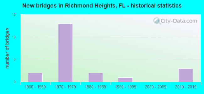
- New bridges - historical statistics
- 21960-1969
- 131970-1979
- 21980-1989
- 11990-1999
- 32010-2019
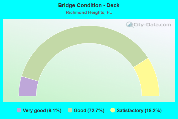
- Bridge Condition - Deck
- 9.1%Very good
- 72.7%Good
- 18.2%Satisfactory
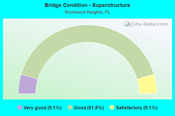
- Bridge Condition - Superstructure
- 9.1%Very good
- 81.8%Good
- 9.1%Satisfactory
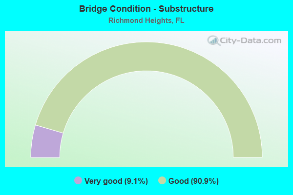
- Bridge Condition - Substructure
- 9.1%Very good
- 90.9%Good
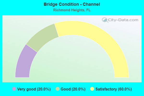
- Bridge Condition - Channel
- 20.0%Very good
- 20.0%Good
- 60.0%Satisfactory
Find on map >> Show street view
Structure Number: 870198, Location: 3.3 MILES NORTH OF US-1 (Lat: 25.627403, Lng: -80.379878), Route carried "on" structure: State highway 821, Year Built: 1973, Year Reconstructed: 2019, Status: Open, Structure Length: 7.62m (25.00ft), Average Daily Traffic: 79,200 (year 2020), Truck Traffic: 8%, Average Future Daily Traffic: 137,412 (year 2042), Design Load: HS 20, Features Intersected: SW 152 ST CORAL REEF DR
Minimum Vertical Clearance: 30+ m (98+ ft), Kilometerpoint: 26.105, Lanes on structure: 5, Lanes under structure: 8, Base Highway Network: Yes, Toll: On toll road, Owner: State Toll Authority, Approaching Roadway Width: 29.3m (96.1ft), Skew: 6 degrees, Material/Design: Prestressed concrete, Design/Construction: Stringer/Multi-beam, Number Of Spans In Main Unit: 4, Length of Maximum Span: 23.0m (75.5ft), Curb-To-Curb Width: 29.3m (96.1ft), Out-to-Out Width: 30.2m (99.1ft)
Condition: Deck: Satisfactory, Superstructure: Good, Substructure: Good, Operating Rating: 45.4 metric tons, Method Used To Determine Operating Rating: Load and Resistance Factor (LRFR), Inventory Rating: 33.3 metric tons, Method Used To Determine Inventory Rating: Load and Resistance Factor (LRFR), Structural Evaluation: Better than present minimum criteria, Deck Geometry: Superior to present desirable criteria, Underclear: High priority of corrective action, Approach Roadway Alignment: Equal to present desirable criteria, Designated Inspection Frequency: Every 24 months, Inspection Date: March 2020, Deck Structure Type: Concrete Cast-file-Place
Find on map >> Show street view
Structure Number: 870199, Location: 3.6 MILES NORTH OF US-1 (Lat: 25.629936, Lng: -80.382417), Route carried "on" structure: State highway 821, Year Built: 1973, Year Reconstructed: 2019, Status: Open, Structure Length: 8.19m (26.87ft), Average Daily Traffic: 93,200 (year 2020), Truck Traffic: 8%, Average Future Daily Traffic: 161,702 (year 2042), Design Load: HS 20, Features Intersected: SW 117 AVE
Minimum Vertical Clearance: 30+ m (98+ ft), Kilometerpoint: 26.483, Lanes on structure: 6, Lanes under structure: 7, Base Highway Network: Yes, Toll: On toll road, Owner: State Toll Authority, Approaching Roadway Width: 28.7m (94.2ft), Skew: 4 degrees, Material/Design: Prestressed concrete, Design/Construction: Stringer/Multi-beam, Number Of Spans In Main Unit: 4, Length of Maximum Span: 24.2m (79.4ft), Curb-To-Curb Width: 28.7m (94.2ft), Out-to-Out Width: 29.6m (97.1ft)
Condition: Deck: Good, Superstructure: Good, Substructure: Good, Operating Rating: 54.7 metric tons, Method Used To Determine Operating Rating: Load Factor (LF), Inventory Rating: 32.7 metric tons, Method Used To Determine Inventory Rating: Load Factor (LF), Structural Evaluation: Better than present minimum criteria, Deck Geometry: Better than present minimum criteria, Underclear: High priority of corrective action, Approach Roadway Alignment: Equal to present desirable criteria, Designated Inspection Frequency: Every 24 months, Inspection Date: March 2020, Deck Structure Type: Concrete Cast-file-Place
Find on map >> Show street view
Structure Number: 8702, Location: 5.1 MILES NORTH OF US-1 (Lat: 25.648625, Lng: -80.386556), Route carried "on" structure: State highway 821, Year Built: 1973, Year Reconstructed: 2019, Status: Open, Structure Length: 12.16m (39.90ft), Average Daily Traffic: 93,200 (year 2020), Truck Traffic: 8%, Average Future Daily Traffic: 161,702 (year 2042), Design Load: HL 93, Features Intersected: Ramp SB 874 & SCL RR
Minimum Vertical Clearance: 30+ m (98+ ft), Kilometerpoint: 28.679, Lanes on structure: 4, Lanes under structure: 1, Base Highway Network: Yes, Toll: On toll road, Owner: State Toll Authority, Approaching Roadway Width: 20.7m (67.9ft), Skew: 4 degrees, Material/Design: Prestressed concrete, Design/Construction: Stringer/Multi-beam, Number Of Spans In Main Unit: 5, Length of Maximum Span: 27.4m (89.9ft), Curb-To-Curb Width: 20.7m (67.9ft), Out-to-Out Width: 22.3m (73.2ft)
Condition: Deck: Good, Superstructure: Good, Substructure: Good, Operating Rating: 48.0 metric tons, Method Used To Determine Operating Rating: Load and Resistance Factor (LRFR), Inventory Rating: 35.6 metric tons, Method Used To Determine Inventory Rating: Load and Resistance Factor (LRFR), Structural Evaluation: Better than present minimum criteria, Deck Geometry: Equal to present minimum criteria, Underclear: Somewhat better than minimum adequacy, Approach Roadway Alignment: Equal to present desirable criteria, Designated Inspection Frequency: Every 24 months, Inspection Date: Febuary 2020, Deck Structure Type: Concrete Cast-file-Place
Find on map >> Show street view
Structure Number: 870405, Location: 3.3 MILES NORTH OF US-1 (Lat: 25.627433, Lng: -80.379508), Route carried "on" structure: State highway 821, Year Built: 1973, Year Reconstructed: 2019, Status: Open, Structure Length: 7.62m (25.00ft), Average Daily Traffic: 79,200 (year 2020), Truck Traffic: 8%, Average Future Daily Traffic: 137,412 (year 2042), Design Load: HS 20+Mod, Features Intersected: SW 152 ST CORAL REEF DR
Minimum Vertical Clearance: 30+ m (98+ ft), Kilometerpoint: 26.086, Lanes on structure: 5, Lanes under structure: 8, Base Highway Network: Yes, Toll: On toll road, Owner: State Toll Authority, Approaching Roadway Width: 32.3m (106.0ft), Skew: 6 degrees, Material/Design: Prestressed concrete, Design/Construction: Stringer/Multi-beam, Number Of Spans In Main Unit: 4, Number Of Approach Spans: 2, Length of Maximum Span: 22.9m (75.1ft), Curb-To-Curb Width: 32.3m (106.0ft), Out-to-Out Width: 34.1m (111.9ft)
Condition: Deck: Good, Superstructure: Good, Substructure: Good, Operating Rating: 63.1 metric tons, Method Used To Determine Operating Rating: Load Factor (LF), Inventory Rating: 33.9 metric tons, Method Used To Determine Inventory Rating: Load Factor (LF), Structural Evaluation: Better than present minimum criteria, Deck Geometry: Superior to present desirable criteria, Underclear: High priority of corrective action, Approach Roadway Alignment: Equal to present desirable criteria, Designated Inspection Frequency: Every 24 months, Inspection Date: March 2020, Deck Structure Type: Concrete Cast-file-Place
Find on map >> Show street view
Structure Number: 870406, Location: 3.6 MILES NORTH OF US-1 (Lat: 25.630347, Lng: -80.382433), Route carried "on" structure: State highway 821, Year Built: 1973, Year Reconstructed: 2019, Status: Open, Structure Length: 8.19m (26.87ft), Average Daily Traffic: 93,200 (year 2020), Truck Traffic: 8%, Average Future Daily Traffic: 161,702 (year 2042), Design Load: HS 20+Mod, Features Intersected: SW 117 AVE
Minimum Vertical Clearance: 30+ m (98+ ft), Kilometerpoint: 26.532, Lanes on structure: 4, Lanes under structure: 7, Base Highway Network: Yes, Toll: On toll road, Owner: State Toll Authority, Approaching Roadway Width: 28.7m (94.2ft), Skew: 4 degrees, Material/Design: Prestressed concrete, Design/Construction: Stringer/Multi-beam, Number Of Spans In Main Unit: 4, Length of Maximum Span: 24.2m (79.4ft), Curb-To-Curb Width: 28.7m (94.2ft), Out-to-Out Width: 29.6m (97.1ft)
Condition: Deck: Good, Superstructure: Good, Substructure: Good, Operating Rating: 57.8 metric tons, Method Used To Determine Operating Rating: Load Factor (LF), Inventory Rating: 34.6 metric tons, Method Used To Determine Inventory Rating: Load Factor (LF), Structural Evaluation: Better than present minimum criteria, Deck Geometry: Superior to present desirable criteria, Underclear: High priority of corrective action, Approach Roadway Alignment: Equal to present desirable criteria, Designated Inspection Frequency: Every 24 months, Inspection Date: March 2020, Deck Structure Type: Concrete Cast-file-Place
Find on map >> Show street view
Structure Number: 870407, Location: 5.1 MILES NORTH OF US-1 (Lat: 25.650250, Lng: -80.384750), Route carried "on" structure: State highway 821, Year Built: 1973, Status: Open, Structure Length: 15.97m (52.40ft), Average Daily Traffic: 93,200 (year 2021), Truck Traffic: 8%, Average Future Daily Traffic: 161,702 (year 2042), Design Load: HS 20+Mod, Features Intersected: SR 874 & SCL RR
Minimum Vertical Clearance: 30+ m (98+ ft), Kilometerpoint: 28.802, Lanes on structure: 2, Lanes under structure: 8, Base Highway Network: Yes, Toll: On toll road, Owner: State Toll Authority, Approaching Roadway Width: 16.8m (55.1ft), Skew: 3 degrees, Material/Design: Steel, Design/Construction: Stringer/Multi-beam, Number Of Spans In Main Unit: 5, Length of Maximum Span: 40.0m (131.2ft), Curb-To-Curb Width: 16.2m (53.1ft), Out-to-Out Width: 16.9m (55.4ft)
Condition: Deck: Good, Superstructure: Good, Substructure: Good, Operating Rating: 82.6 metric tons, Method Used To Determine Operating Rating: Load Factor (LF), Inventory Rating: 49.5 metric tons, Method Used To Determine Inventory Rating: Load Factor (LF), Structural Evaluation: Better than present minimum criteria, Deck Geometry: Superior to present desirable criteria, Underclear: Meets minimum limits, Approach Roadway Alignment: Better than present minimum criteria, Designated Inspection Frequency: Every 24 months, Inspection Date: March 2020, Bridge Improvement Cost: $160,000, Total Project Cost: $160,000, Deck Structure Type: Concrete Cast-file-Place
Find on map >> Show street view
Structure Number: 870913, Location: 0.6 MI S of SW 120th St (Lat: 25.648406, Lng: -80.386133), Route carried "on" structure: Ramp State highway 821, Year Built: 2019, Status: Open, Structure Length: 17.40m (57.09ft), Average Daily Traffic: 4,600 (year 2020), Truck Traffic: 6%, Average Future Daily Traffic: 9,500 (year 2042), Design Load: HL 93, Features Intersected: SR 874 and SCLRR
Minimum Vertical Clearance: 6.40m (21.00ft), Kilometerpoint: 28.679, Lanes on structure: 1, Lanes under structure: 4, Base Highway Network: Yes, Toll: On toll road, Owner: State Toll Authority, Approaching Roadway Width: 8.2m (26.9ft), Skew: 9 degrees, Material/Design: Prestressed concrete, Design/Construction: Stringer/Multi-beam, Number Of Spans In Main Unit: 5, Length of Maximum Span: 37.4m (122.7ft), Curb-To-Curb Width: 8.2m (26.9ft), Out-to-Out Width: 9.2m (30.2ft)
Condition: Deck: Very good, Superstructure: Very good, Substructure: Very good, Operating Rating: 63.0 metric tons, Method Used To Determine Operating Rating: Load and Resistance Factor (LRFR), Inventory Rating: 37.6 metric tons, Method Used To Determine Inventory Rating: Load and Resistance Factor (LRFR), Structural Evaluation: Equal to present desirable criteria, Deck Geometry: Superior to present desirable criteria, Underclear: Equal to present minimum criteria, Approach Roadway Alignment: Equal to present desirable criteria, Designated Inspection Frequency: Every 24 months, Inspection Date: Febuary 2020, Deck Structure Type: Concrete Cast-file-Place
Find on map >> Show street view
Structure Number: 874004, Location: 0.13 mile N/O SW 152nd St (Lat: 25.627833, Lng: -80.445139), Route carried "on" structure: City street , Year Built: 1993, Status: Open, Structure Length: 2.53m (8.30ft), Average Daily Traffic: 306 (year 2020), Truck Traffic: 2%, Average Future Daily Traffic: 541 (year 2042), Design Load: HS 20, Features Intersected: Black Creek Canal, Facility Carried by Structure: SW 155th Avenue
Minimum Vertical Clearance: 30+ m (98+ ft), Kilometerpoint: 0.264, Lanes on structure: 2, Owner: County Highway Agency, Approaching Roadway Width: 8.2m (26.9ft), Material/Design: Concrete continuous, Design/Construction: Slab, Number Of Spans In Main Unit: 3, Length of Maximum Span: 9.4m (30.8ft), Curb or Sidewalk Widths: Left: 1.6m (5.2ft), Right: 1.6m (5.2ft), Curb-To-Curb Width: 9.1m (29.9ft), Out-to-Out Width: 13.7m (44.9ft)
Condition: Deck: Good, Superstructure: Good, Substructure: Good, Channel: Satisfactory, Operating Rating: 56.0 metric tons, Method Used To Determine Operating Rating: Load Factor (LF), Inventory Rating: 34.4 metric tons, Method Used To Determine Inventory Rating: Load Factor (LF), Structural Evaluation: Better than present minimum criteria, Deck Geometry: Equal to present minimum criteria, Waterway Adequacy: Better than present minimum criteria, Approach Roadway Alignment: Equal to present desirable criteria, Designated Inspection Frequency: Every 24 months, Underwater Inspection Frequency: Every 24 months, Inspection Date: August 2020, Underwater Inspection Date: August 2020, Deck Structure Type: Concrete Cast-file-Place
Find on map >> Show street view
Structure Number: 874006, Location: 0.2 Mile N of SW 152nd St (Lat: 25.627878, Lng: -80.438933), Route carried "on" structure: City street , Year Built: 1989, Status: Open, Structure Length: 2.83m (9.28ft), Average Daily Traffic: 1,102 (year 2020), Truck Traffic: 3%, Average Future Daily Traffic: 4,060 (year 2042), Design Load: HS 20, Features Intersected: Black Creek Canal, Facility Carried by Structure: SW 152nd Ave
Minimum Vertical Clearance: 30+ m (98+ ft), Kilometerpoint: 0.286, Lanes on structure: 2, Owner: County Highway Agency, Approaching Roadway Width: 7.3m (24.0ft), Material/Design: Concrete, Design/Construction: Slab, Number Of Spans In Main Unit: 3, Length of Maximum Span: 9.4m (30.8ft), Curb or Sidewalk Widths: Left: 1.6m (5.2ft), Right: 1.6m (5.2ft), Curb-To-Curb Width: 9.1m (29.9ft), Out-to-Out Width: 13.7m (44.9ft)
Condition: Deck: Good, Superstructure: Good, Substructure: Good, Channel: Satisfactory, Operating Rating: 57.2 metric tons, Method Used To Determine Operating Rating: Load Factor (LF), Inventory Rating: 34.7 metric tons, Method Used To Determine Inventory Rating: Load Factor (LF), Structural Evaluation: Better than present minimum criteria, Deck Geometry: Somewhat better than minimum adequacy, Waterway Adequacy: Superior to present desirable criteria, Approach Roadway Alignment: Equal to present desirable criteria, Designated Inspection Frequency: Every 24 months, Underwater Inspection Frequency: Every 24 months, Inspection Date: June 2020, Underwater Inspection Date: June 2020, Deck Structure Type: Concrete Cast-file-Place
Find on map >> Show street view
Structure Number: 874292, Location: 1 Mile E of US-1 (Lat: 25.614489, Lng: -80.328417), Route carried "on" structure: County highway , Year Built: 1965, Status: Open, Structure Length: 2.43m (7.97ft), Average Daily Traffic: 6,720 (year 2020), Truck Traffic: 5%, Average Future Daily Traffic: 10,830 (year 2042), Design Load: HL 93, Features Intersected: Canal C-100, Facility Carried by Structure: SW 168th Street
Minimum Vertical Clearance: 30+ m (98+ ft), Kilometerpoint: 1.872, Lanes on structure: 2, Owner: County Highway Agency, Approaching Roadway Width: 7.5m (24.6ft), Material/Design: Prestressed concrete, Design/Construction: Slab, Number Of Spans In Main Unit: 3, Length of Maximum Span: 8.1m (26.6ft), Curb or Sidewalk Widths: Left: 1.2m (3.9ft), Right: 1.2m (3.9ft), Curb-To-Curb Width: 8.6m (28.2ft), Out-to-Out Width: 11.6m (38.1ft)
Condition: Deck: Good, Superstructure: Good, Substructure: Good, Channel: Good, Operating Rating: 55.2 metric tons, Method Used To Determine Operating Rating: Load and Resistance Factor (LRFR), Inventory Rating: 42.5 metric tons, Method Used To Determine Inventory Rating: Load and Resistance Factor (LRFR), Structural Evaluation: Better than present minimum criteria, Deck Geometry: High priority of replacement, Waterway Adequacy: Better than present minimum criteria, Approach Roadway Alignment: Equal to present desirable criteria, Designated Inspection Frequency: Every 24 months, Underwater Inspection Frequency: Every 24 months, Inspection Date: March 2020, Underwater Inspection Date: March 2020, Deck Structure Type: Concrete Precast Panels, Wearing Surface/Protective System: Wearing Surface: Bituminous
Find on map >> Show street view
Structure Number: 874293, Location: 0.1 Mile S of SW 173rd St (Lat: 25.610583, Lng: -80.310222), Route carried "on" structure: County highway , Year Built: 1960, Status: Open, Structure Length: 2.76m (9.06ft), Average Daily Traffic: 15,606 (year 2014), Truck Traffic: 5%, Average Future Daily Traffic: 23,714 (year 2036), Design Load: HS 20, Features Intersected: Cutler Canal C-100, Facility Carried by Structure: Old Cutler Road
Minimum Vertical Clearance: 30+ m (98+ ft), Kilometerpoint: 4.064, Lanes on structure: 2, Owner: County Highway Agency, Approaching Roadway Width: 7.3m (24.0ft), Material/Design: Prestressed concrete, Design/Construction: Slab, Number Of Spans In Main Unit: 3, Length of Maximum Span: 9.2m (30.2ft), Curb or Sidewalk Widths: Left: 1.2m (3.9ft), Right: 1.9m (6.2ft), Curb-To-Curb Width: 7.6m (24.9ft), Out-to-Out Width: 11.3m (37.1ft)
Condition: Deck: Satisfactory, Superstructure: Satisfactory, Substructure: Good, Channel: Very good, Operating Rating: 41.3 metric tons, Method Used To Determine Operating Rating: Load Factor (LF), Inventory Rating: 25.0 metric tons, Method Used To Determine Inventory Rating: Load Factor (LF), Structural Evaluation: Equal to present minimum criteria, Deck Geometry: High priority of replacement, Waterway Adequacy: Equal to present desirable criteria, Approach Roadway Alignment: Equal to present desirable criteria, Designated Inspection Frequency: Every 24 months, Underwater Inspection Frequency: Every 24 months, Inspection Date: May 2020, Underwater Inspection Date: May 2020, Deck Structure Type: Concrete Precast Panels, Wearing Surface/Protective System: Wearing Surface: Bituminous
Find on map >> Show street view
Structure Number: 874442, Location: 0.8 Mile W of SW 137 Ave. (Lat: 25.625833, Lng: -80.426611), Route carried "on" structure: County highway , Year Built: 1983, Status: Open, Structure Length: 1.01m (3.31ft), Average Daily Traffic: 17,177 (year 2020), Truck Traffic: 3%, Average Future Daily Traffic: 27,607 (year 2042), Design Load: HS 20, Features Intersected: Black Creek Canal (C-1W), Facility Carried by Structure: SW 152nd Street
Minimum Vertical Clearance: 30+ m (98+ ft), Kilometerpoint: 5.430, Lanes on structure: 4, Owner: County Highway Agency, Approaching Roadway Width: 17.6m (57.7ft), Skew: 3 degrees, Material/Design: Steel, Design/Construction: Culvert, Number Of Spans In Main Unit: 1, Length of Maximum Span: 10.1m (33.1ft), Curb or Sidewalk Widths: Left: 2.0m (6.6ft), Right: 2.0m (6.6ft)
Condition: Channel: Satisfactory, Culverts: Good, Inventory Rating: 86.7 metric tons, Method Used To Determine Inventory Rating: Load Factor (LF), Structural Evaluation: Better than present minimum criteria, Waterway Adequacy: Equal to present desirable criteria, Approach Roadway Alignment: Equal to present desirable criteria, Designated Inspection Frequency: Every 24 months, Underwater Inspection Frequency: Every 24 months, Inspection Date: August 2020, Underwater Inspection Date: August 2020
Find on map >> Show street view
Structure Number: 870198, Location: 3.3 MILES NORTH OF US-1 (Lat: 25.627403, Lng: -80.379878), Route carried "under" structure: State highway 992, Year Built: 1973, Structure Length: 0. m, Average Daily Traffic: 34,500 (year 2020), Truck Traffic: 5%, Features Intersected: SW 152 ST CORAL REEF DR, Facility Carried by Structure: SR821 SB HEFT 16.1
Minimum Vertical Clearance: 5.12m (16.80ft), Kilometerpoint: 0.076, Lanes on structure: 5, Lanes under structure: 8, Material/Design: Prestressed concrete, Design/Construction: Stringer/Multi-beam, Length of Maximum Span: 23.0m (75.5ft)
Find on map >> Show street view
Structure Number: 870199, Location: 3.6 MILES NORTH OF US-1 (Lat: 25.629936, Lng: -80.382417), Route carried "under" structure: City street , Year Built: 1973, Structure Length: 0. m, Average Daily Traffic: 93,200 (year 2020), Truck Traffic: 8%, Features Intersected: SW 117 AVE, Facility Carried by Structure: SR821 SB HEFT 16.4
Minimum Vertical Clearance: 4.94m (16.21ft), Kilometerpoint: 26.483, Lanes on structure: 6, Lanes under structure: 7, Material/Design: Prestressed concrete, Design/Construction: Stringer/Multi-beam, Length of Maximum Span: 24.2m (79.4ft)
Find on map >> Show street view
Structure Number: 8702, Location: 5.1 MILES NORTH OF US-1 (Lat: 25.648625, Lng: -80.386556), Route carried "under" structure: Ramp State highway 874, Year Built: 1973, Structure Length: 0. m, Average Daily Traffic: 2,800 (year 2020), Truck Traffic: 8%, Features Intersected: Ramp SB 874 & SCL RR, Facility Carried by Structure: SR821 SB HEFT 17.7
Minimum Vertical Clearance: 6.52m (21.39ft), Kilometerpoint: 28.679, Lanes on structure: 4, Lanes under structure: 1, Toll: On toll road, Material/Design: Prestressed concrete, Design/Construction: Stringer/Multi-beam, Length of Maximum Span: 27.4m (89.9ft)
Find on map >> Show street view
Structure Number: 870405, Location: 3.3 MILES NORTH OF US-1 (Lat: 25.627433, Lng: -80.379508), Route carried "under" structure: State highway 992, Year Built: 1973, Structure Length: 0. m, Average Daily Traffic: 34,500 (year 2020), Truck Traffic: 5%, Features Intersected: SW 152 ST CORAL REEF DR, Facility Carried by Structure: SR821 NB HEFT 16.1
Minimum Vertical Clearance: 4.94m (16.21ft), Kilometerpoint: 0.109, Lanes on structure: 5, Lanes under structure: 8, Material/Design: Prestressed concrete, Design/Construction: Stringer/Multi-beam, Length of Maximum Span: 22.9m (75.1ft)
Find on map >> Show street view
Structure Number: 870406, Location: 3.6 MILES NORTH OF US-1 (Lat: 25.630347, Lng: -80.382433), Route carried "under" structure: City street , Year Built: 1973, Structure Length: 0. m, Average Daily Traffic: 93,200 (year 2020), Truck Traffic: 8%, Features Intersected: SW 117 AVE, Facility Carried by Structure: SR821 NB HEFT 16.4
Minimum Vertical Clearance: 4.97m (16.31ft), Kilometerpoint: 26.532, Lanes on structure: 4, Lanes under structure: 7, Material/Design: Prestressed concrete, Design/Construction: Stringer/Multi-beam, Length of Maximum Span: 24.2m (79.4ft)
Find on map >> Show street view
Structure Number: 870407, Location: 5.1 MILES NORTH OF US-1 (Lat: 25.650250, Lng: -80.384750), Route carried "under" structure: State highway 874, Year Built: 1973, Structure Length: 0. m, Average Daily Traffic: 95,800 (year 2021), Truck Traffic: 8%, Features Intersected: SR 874 & SCL RR, Facility Carried by Structure: SR821 HEFT NB 17.8
Minimum Vertical Clearance: 5.03m (16.50ft), Kilometerpoint: 28.802, Lanes on structure: 2, Lanes under structure: 7, Toll: On toll road, Material/Design: Steel, Design/Construction: Stringer/Multi-beam, Length of Maximum Span: 40.0m (131.2ft)
Find on map >> Show street view
Structure Number: 870407, Location: 5.1 MILES NORTH OF US-1 (Lat: 25.650250, Lng: -80.384750), Route carried "under" structure: Ramp State highway 874, Year Built: 1973, Structure Length: 0. m, Average Daily Traffic: 14,000 (year 2021), Truck Traffic: 6%, Features Intersected: SR 874 & SCL RR, Facility Carried by Structure: SR821 HEFT NB 17.8
Minimum Vertical Clearance: 5.03m (16.50ft), Kilometerpoint: 0.538, Lanes on structure: 2, Lanes under structure: 1, Toll: On toll road, Material/Design: Steel, Design/Construction: Stringer/Multi-beam, Length of Maximum Span: 40.0m (131.2ft)
Find on map >> Show street view
Structure Number: 870913, Location: 0.6 MI S of SW 120th St (Lat: 25.648406, Lng: -80.386133), Route carried "under" structure: Ramp State highway 824, Year Built: 2019, Structure Length: 0. m, Average Daily Traffic: 2,800 (year 2020), Truck Traffic: 5%, Features Intersected: SR 874 and SCLRR, Facility Carried by Structure: SR 821 SB Ramp
Minimum Vertical Clearance: 7.35m (24.11ft), Kilometerpoint: 28.679, Lanes on structure: 1, Lanes under structure: 1, Toll: On toll road, Material/Design: Prestressed concrete, Design/Construction: Stringer/Multi-beam, Length of Maximum Span: 37.4m (122.7ft)
Find on map >> Show street view
Structure Number: 870913, Location: 0.6 MI S of SW 120th St (Lat: 25.648406, Lng: -80.386133), Route carried "under" structure: Ramp State highway 821, Year Built: 2019, Structure Length: 0. m, Average Daily Traffic: 37,700 (year 2020), Truck Traffic: 5%, Features Intersected: SR 874 and SCLRR
Minimum Vertical Clearance: 6.64m (21.78ft), Kilometerpoint: 0.000, Lanes on structure: 1, Lanes under structure: 2, Toll: On toll road, Material/Design: Prestressed concrete, Design/Construction: Stringer/Multi-beam, Length of Maximum Span: 37.4m (122.7ft)