Bridge Statistics for Richmond, Michigan (MI)
Condition, Traffic, Stress, Structural Evaluation, Project Costs
- National Bridge Inventory (NBI) Statistics
- 12Number of bridges
- 135ft / 41.0mTotal length
- $936,000Total costs
- 113,117Total average daily traffic
- 13,649Total average daily truck traffic
- National Bridge Inventory (NBI) Registered Bridges for Richmond
- No street view available for this location
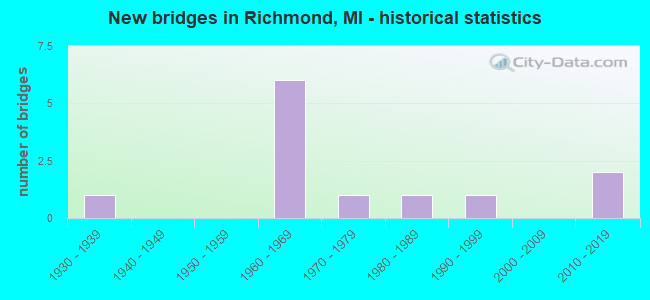
- New bridges - historical statistics
- 11930-1939
- 61960-1969
- 11970-1979
- 11980-1989
- 11990-1999
- 22010-2019


- Bridge Condition - Deck
- 33.3%Good
- 33.3%Satisfactory
- 16.7%Fair
- 16.7%Serious

- Bridge Condition - Superstructure
- 16.7%Very good
- 33.3%Good
- 33.3%Satisfactory
- 16.7%Critical

- Bridge Condition - Substructure
- 50.0%Good
- 33.3%Satisfactory
- 16.7%Fair

- Bridge Condition - Channel
- 50.0%Very good
- 16.7%Satisfactory
- 16.7%Fair
- 16.7%Poor

- Bridge Condition - Culverts
- 66.7%Very good
- 33.3%Serious
Find on map >> Show street view
Structure Number: 9998, Location: 1.6 MI NE OF MACOMB COL (Lat: 42.751194, Lng: -82.708503), Route carried "on" structure: County highway , Year Built: 1964, Year Reconstructed: 2007, Status: Open, Structure Length: 9.27m (30.41ft), Average Daily Traffic: 500 (year 1996), Truck Traffic: 2%, Average Future Daily Traffic: 575 (year 2016), Design Load: H 20, Features Intersected: I-94, Facility Carried by Structure: MEISNER RD
Minimum Vertical Clearance: 30.48m (100.00ft), Kilometerpoint: 1.867, Lanes on structure: 2, Lanes under structure: 4, Owner: State Highway Agency, Approaching Roadway Width: 12.8m (42.0ft), Skew: 4 degrees, Material/Design: Steel, Design/Construction: Stringer/Multi-beam, Number Of Spans In Main Unit: 4, Length of Maximum Span: 30.5m (100.1ft), Curb-To-Curb Width: 7.3m (24.0ft), Out-to-Out Width: 9.6m (31.5ft)
Condition: Deck: Fair, Superstructure: Good, Substructure: Satisfactory, Operating Rating: 62.9 metric tons, Method Used To Determine Operating Rating: Load Factor (LF) rating reported by rating factor (RF) method using MS18 loading, Inventory Rating: 37.6 metric tons, Method Used To Determine Inventory Rating: Load Factor (LF) rating reported by rating factor (RF) method using MS18 loading, Structural Evaluation: Equal to present minimum criteria, Deck Geometry: Meets minimum limits, Underclear: Somewhat better than minimum adequacy, Approach Roadway Alignment: Equal to present desirable criteria, Designated Inspection Frequency: Every 24 months, Inspection Date: August 2020, Deck Structure Type: Concrete Cast-file-Place, Wearing Surface/Protective System: Wearing Surface: Epoxy Overlay
Find on map >> Show street view
Structure Number: 9999, Location: 3.2 MI NE OF MACOMB COL (Lat: 42.764192, Lng: -82.692731), Route carried "on" structure: County highway , Year Built: 1964, Year Reconstructed: 2007, Status: Open, Structure Length: 9.27m (30.41ft), Average Daily Traffic: 450 (year 1991), Truck Traffic: 2%, Average Future Daily Traffic: 518 (year 2011), Design Load: H 20, Features Intersected: I-94, Facility Carried by Structure: CHURCH RD
Minimum Vertical Clearance: 30.48m (100.00ft), Kilometerpoint: 8.115, Lanes on structure: 2, Lanes under structure: 4, Owner: State Highway Agency, Approaching Roadway Width: 12.8m (42.0ft), Skew: 4 degrees, Material/Design: Steel, Design/Construction: Stringer/Multi-beam, Number Of Spans In Main Unit: 4, Length of Maximum Span: 30.5m (100.1ft), Curb-To-Curb Width: 7.3m (24.0ft), Out-to-Out Width: 9.6m (31.5ft)
Condition: Deck: Satisfactory, Superstructure: Satisfactory, Substructure: Good, Operating Rating: 62.9 metric tons, Method Used To Determine Operating Rating: Load Factor (LF) rating reported by rating factor (RF) method using MS18 loading, Inventory Rating: 37.6 metric tons, Method Used To Determine Inventory Rating: Load Factor (LF) rating reported by rating factor (RF) method using MS18 loading, Structural Evaluation: Equal to present minimum criteria, Deck Geometry: Meets minimum limits, Underclear: Meets minimum limits, Approach Roadway Alignment: Equal to present desirable criteria, Length Of Structure Improvement: 9.27m (30.41ft), Designated Inspection Frequency: Every 24 months, Inspection Date: August 2020, Bridge Improvement Cost: $299,000, Roadway Improvement Cost: $19,000, Total Project Cost: $228,000, Deck Structure Type: Concrete Cast-file-Place, Wearing Surface/Protective System: Wearing Surface: Epoxy Overlay
Find on map >> Show street view
Structure Number: 1, Location: 4.3 MI NE OF MACOMB COL (Lat: 42.779958, Lng: -82.673297), Route carried "on" structure: County highway , Year Built: 1964, Year Reconstructed: 2007, Status: Open, Structure Length: 9.27m (30.41ft), Average Daily Traffic: 480 (year 1991), Truck Traffic: 2%, Average Future Daily Traffic: 552 (year 2011), Design Load: H 15, Features Intersected: I-94, Facility Carried by Structure: MELDRUM RD
Minimum Vertical Clearance: 30.48m (100.00ft), Kilometerpoint: 10.585, Lanes on structure: 2, Lanes under structure: 4, Owner: State Highway Agency, Approaching Roadway Width: 12.2m (40.0ft), Skew: 4 degrees, Material/Design: Steel, Design/Construction: Stringer/Multi-beam, Number Of Spans In Main Unit: 4, Length of Maximum Span: 30.5m (100.1ft), Curb-To-Curb Width: 7.3m (24.0ft), Out-to-Out Width: 9.6m (31.5ft)
Condition: Deck: Satisfactory, Superstructure: Satisfactory, Substructure: Satisfactory, Operating Rating: 47.0 metric tons, Method Used To Determine Operating Rating: Load and Resistance Factor Rating (LRFR) rating reported by rating factor(RF) method using HL-93 loadings, Inventory Rating: 36.3 metric tons, Method Used To Determine Inventory Rating: Load and Resistance Factor Rating (LRFR) rating reported by rating factor(RF) method using HL-93 loadings, Structural Evaluation: Equal to present minimum criteria, Deck Geometry: Meets minimum limits, Underclear: Meets minimum limits, Approach Roadway Alignment: Equal to present desirable criteria, Length Of Structure Improvement: 9.27m (30.41ft), Designated Inspection Frequency: Every 24 months, Inspection Date: August 2020, Bridge Improvement Cost: $295,000, Roadway Improvement Cost: $19,000, Total Project Cost: $226,000, Deck Structure Type: Concrete Cast-file-Place, Wearing Surface/Protective System: Wearing Surface: Epoxy Overlay
Find on map >> Show street view
Structure Number: 1004, Location: SEC. 32 COLUMBUS TWP. (Lat: 42.810561, Lng: -82.704617), Route carried "on" structure: County highway , Year Built: 2010, Status: Open, Structure Length: 0.73m (2.40ft), Average Daily Traffic: 3,300 (year 1994), Truck Traffic: 4%, Average Future Daily Traffic: 4,700 (year 2014), Design Load: HS 20+Mod, Features Intersected: RICHMOND-COLUMBUS DRAIN, Facility Carried by Structure: DIVISION ROAD
Minimum Vertical Clearance: 30.48m (100.00ft), Kilometerpoint: 2.853, Lanes on structure: 2, Owner: County Highway Agency, Approaching Roadway Width: 10.9m (35.8ft), Material/Design: Aluminum, Iron, Design/Construction: Culvert, Number Of Spans In Main Unit: 1, Length of Maximum Span: 7.3m (24.0ft), Curb-To-Curb Width: 12.7m (41.7ft), Out-to-Out Width: 19.5m (64.0ft)
Condition: Channel: Very good, Culverts: Very good, Operating Rating: 46.0 metric tons, Method Used To Determine Operating Rating: Load Factor (LF) rating reported by rating factor (RF) method using MS18 loading, Inventory Rating: 27.5 metric tons, Method Used To Determine Inventory Rating: Load Factor (LF) rating reported by rating factor (RF) method using MS18 loading, Structural Evaluation: Equal to present minimum criteria, Deck Geometry: Equal to present minimum criteria, Waterway Adequacy: Equal to present desirable criteria, Approach Roadway Alignment: Equal to present desirable criteria, Designated Inspection Frequency: Every 24 months, Inspection Date: Febuary 2022, Wearing Surface/Protective System: Wearing Surface: Bituminous
Find on map >> Show street view
Structure Number: 10043, Location: SEC. 32 COLUMBUS TWP. (Lat: 42.818683, Lng: -82.712478), Route carried "on" structure: County highway 7746, Year Built: 2015, Status: Open, Structure Length: 0.84m (2.76ft), Average Daily Traffic: 7,209 (year 2014), Truck Traffic: 8%, Average Future Daily Traffic: 10,700 (year 2034), Design Load: HS 20+Mod, Features Intersected: RICHMOND-COLUMBUS DN EXT, Facility Carried by Structure: GRATIOT ROAD
Minimum Vertical Clearance: 30.48m (100.00ft), Kilometerpoint: 2.927, Lanes on structure: 2, Owner: County Highway Agency, Approaching Roadway Width: 15.2m (49.9ft), Skew: 3 degrees, Material/Design: Concrete, Design/Construction: Culvert, Number Of Spans In Main Unit: 1, Length of Maximum Span: 7.8m (25.6ft), Curb-To-Curb Width: 13.4m (44.0ft), Out-to-Out Width: 15.2m (49.9ft)
Condition: Channel: Very good, Culverts: Very good, Operating Rating: 64.8 metric tons, Method Used To Determine Operating Rating: Load and Resistance Factor Rating (LRFR) rating reported by rating factor(RF) method using HL-93 loadings, Inventory Rating: 49.9 metric tons, Method Used To Determine Inventory Rating: Load and Resistance Factor Rating (LRFR) rating reported by rating factor(RF) method using HL-93 loadings, Structural Evaluation: Equal to present desirable criteria, Deck Geometry: Equal to present minimum criteria, Waterway Adequacy: Better than present minimum criteria, Approach Roadway Alignment: Equal to present desirable criteria, Designated Inspection Frequency: Every 24 months, Inspection Date: Febuary 2020, Wearing Surface/Protective System: Wearing Surface: Low Slump Concrete
Find on map >> Show street view
Structure Number: 10044, Location: SEC. 32 COLUMBUS TWP. (Lat: 42.824503, Lng: -82.698544), Route carried "on" structure: County highway 7746, Year Built: 1932, Status: Posted for load, Structure Length: 3.75m (12.30ft), Average Daily Traffic: 6,959 (year 2018), Truck Traffic: 11%, Average Future Daily Traffic: 10,300 (year 2038), Design Load: H 20, Features Intersected: BELLE RIVER, Facility Carried by Structure: GRATIOT ROAD
Minimum Vertical Clearance: 30.48m (100.00ft), Kilometerpoint: 4.238, Lanes on structure: 2, Owner: County Highway Agency, Approaching Roadway Width: 13.4m (44.0ft), Material/Design: Steel, Design/Construction: Stringer/Multi-beam, Number Of Spans In Main Unit: 2, Length of Maximum Span: 17.9m (58.7ft), Curb or Sidewalk Widths: Left: 0.7m (2.3ft), Right: 0.7m (2.3ft), Curb-To-Curb Width: 12.2m (40.0ft), Out-to-Out Width: 14.7m (48.2ft)
Condition: Deck: Serious, Superstructure: Critical, Substructure: Fair, Channel: Fair, Operating Rating: 39.2 metric tons, Method Used To Determine Operating Rating: Load Factor (LF) rating reported by rating factor (RF) method using MS18 loading, Inventory Rating: 23.3 metric tons, Method Used To Determine Inventory Rating: Load Factor (LF) rating reported by rating factor (RF) method using MS18 loading, Structural Evaluation: High priority of replacement, Deck Geometry: Somewhat better than minimum adequacy, Waterway Adequacy: Better than present minimum criteria, Approach Roadway Alignment: Equal to present desirable criteria, Bridge Posting: Required (Relationship of Operating Rating to Maximum Legal Load: > 39.9% below), Length Of Structure Improvement: 4.27m (14.01ft), Designated Inspection Frequency: Every 6 months, Inspection Date: Febuary 2022, Bridge Improvement Cost: $399,000, Roadway Improvement Cost: $40,000, Total Project Cost: $470,000, Deck Structure Type: Concrete Cast-file-Place, Wearing Surface/Protective System: Wearing Surface: Monolithic Concrete
Find on map >> Show street view
Structure Number: 1009, Location: SEC. 4-5 CASCO TWP. (Lat: 42.808294, Lng: -82.694997), Route carried "on" structure: County highway , Year Built: 1975, Status: Posted for load, Structure Length: 1.06m (3.48ft), Average Daily Traffic: 378 (year 2019), Truck Traffic: 4%, Average Future Daily Traffic: 560 (year 2039), Design Load: H 20, Features Intersected: JEROME CREEK, Facility Carried by Structure: CHURCH ROAD
Minimum Vertical Clearance: 30.48m (100.00ft), Kilometerpoint: 13.017, Lanes on structure: 2, Owner: County Highway Agency, Approaching Roadway Width: 7.3m (24.0ft), Material/Design: Steel, Design/Construction: Culvert, Number Of Spans In Main Unit: 3, Length of Maximum Span: 3.0m (9.8ft), Out-to-Out Width: 10.7m (35.1ft)
Condition: Channel: Poor, Culverts: Serious, Operating Rating: 13.0 metric tons, Method Used To Determine Operating Rating: Load and Resistance Factor Rating (LRFR) rating reported by rating factor(RF) method using HL-93 loadings, Inventory Rating: 10.0 metric tons, Method Used To Determine Inventory Rating: Load and Resistance Factor Rating (LRFR) rating reported by rating factor(RF) method using HL-93 loadings, Structural Evaluation: High priority of corrective action, Waterway Adequacy: Equal to present minimum criteria, Approach Roadway Alignment: Equal to present desirable criteria, Bridge Posting: Required (Relationship of Operating Rating to Maximum Legal Load: > 39.9% below), Designated Inspection Frequency: Every 6 months, Inspection Date: December 2021, Wearing Surface/Protective System: Wearing Surface: Gravel
Find on map >> Show street view
Structure Number: 10147, Location: SEC. 20-29 COLUMBUS TWP. (Lat: 42.840558, Lng: -82.708447), Route carried "on" structure: ServiceCounty highway , Year Built: 1981, Status: Open, Structure Length: 2.89m (9.48ft), Average Daily Traffic: 155 (year 1994), Truck Traffic: 3%, Average Future Daily Traffic: 310 (year 2014), Design Load: HS 20+Mod, Features Intersected: BELLE RIVER, Facility Carried by Structure: BIG HAND ROAD
Minimum Vertical Clearance: 30.48m (100.00ft), Kilometerpoint: 2.229, Lanes on structure: 2, Owner: County Highway Agency, Approaching Roadway Width: 6.7m (22.0ft), Material/Design: Prestressed concrete, Design/Construction: Box Beam or Girders - Multiple, Number Of Spans In Main Unit: 2, Length of Maximum Span: 13.9m (45.6ft), Curb-To-Curb Width: 9.4m (30.8ft), Out-to-Out Width: 9.6m (31.5ft)
Condition: Deck: Good, Superstructure: Good, Substructure: Good, Channel: Satisfactory, Operating Rating: 62.0 metric tons, Method Used To Determine Operating Rating: Load Factor (LF), Inventory Rating: 37.1 metric tons, Method Used To Determine Inventory Rating: Load Factor (LF), Structural Evaluation: Better than present minimum criteria, Deck Geometry: Equal to present minimum criteria, Waterway Adequacy: Better than present minimum criteria, Approach Roadway Alignment: Better than present minimum criteria, Length Of Structure Improvement: 1.22m (4.00ft), Designated Inspection Frequency: Every 24 months, Inspection Date: Febuary 2020, Roadway Improvement Cost: $10,000, Total Project Cost: $12,000, Deck Structure Type: Concrete Cast-file-Place, Wearing Surface/Protective System: Wearing Surface: Bituminous, Membrane: Preformed Fabric, Deck Protection: Epoxy Coated Reinforcing
Find on map >> Show street view
Structure Number: 10153, Location: SEC. 19 COLUMBUS TWP. (Lat: 42.851122, Lng: -82.723008), Route carried "on" structure: ServiceCounty highway , Year Built: 1991, Status: Open, Structure Length: 3.96m (12.99ft), Average Daily Traffic: 380 (year 1994), Average Future Daily Traffic: 460 (year 2014), Design Load: HS 20+Mod, Features Intersected: BELLE RIVER, Facility Carried by Structure: KRONNER ROAD
Minimum Vertical Clearance: 30.48m (100.00ft), Kilometerpoint: 3.555, Lanes on structure: 2, Owner: County Highway Agency, Approaching Roadway Width: 9.1m (29.9ft), Skew: 1 degrees, Material/Design: Prestressed concrete, Design/Construction: Box Beam or Girders - Multiple, Number Of Spans In Main Unit: 3, Length of Maximum Span: 13.1m (43.0ft), Curb-To-Curb Width: 9.8m (32.2ft), Out-to-Out Width: 10.4m (34.1ft)
Condition: Deck: Good, Superstructure: Very good, Substructure: Good, Channel: Very good, Operating Rating: 75.5 metric tons, Method Used To Determine Operating Rating: Load Factor (LF) rating reported by rating factor (RF) method using MS18 loading, Inventory Rating: 45.0 metric tons, Method Used To Determine Inventory Rating: Load Factor (LF) rating reported by rating factor (RF) method using MS18 loading, Structural Evaluation: Better than present minimum criteria, Deck Geometry: Better than present minimum criteria, Waterway Adequacy: Equal to present minimum criteria, Approach Roadway Alignment: Equal to present minimum criteria, Designated Inspection Frequency: Every 24 months, Inspection Date: Febuary 2020, Deck Structure Type: Concrete Cast-file-Place, Wearing Surface/Protective System: Wearing Surface: Bituminous
Find on map >> Show street view
Structure Number: 9998, Location: 1.6 MI NE OF MACOMB COL (Lat: 42.751194, Lng: -82.708503), Route carried "under" structure: Interstate 94, Year Built: 1964, Structure Length: 0. m, Average Daily Traffic: 31,102 (year 2007), Truck Traffic: 13%, Features Intersected: I-94, Facility Carried by Structure: MEISNER RD
Minimum Vertical Clearance: 5.05m (16.57ft), Kilometerpoint: 2.664, Lanes on structure: 2, Lanes under structure: 4, Material/Design: Steel, Design/Construction: Stringer/Multi-beam, Length of Maximum Span: 30.5m (100.1ft)
Find on map >> Show street view
Structure Number: 9999, Location: 3.2 MI NE OF MACOMB COL (Lat: 42.764192, Lng: -82.692731), Route carried "under" structure: Interstate 94, Year Built: 1964, Structure Length: 0. m, Average Daily Traffic: 31,102 (year 2007), Truck Traffic: 13%, Features Intersected: I-94, Facility Carried by Structure: CHURCH RD
Minimum Vertical Clearance: 5.00m (16.40ft), Kilometerpoint: 4.600, Lanes on structure: 2, Lanes under structure: 4, Material/Design: Steel, Design/Construction: Stringer/Multi-beam, Length of Maximum Span: 30.5m (100.1ft)
Find on map >> Show street view
Structure Number: 1, Location: 4.3 MI NE OF MACOMB COL (Lat: 42.779958, Lng: -82.673297), Route carried "under" structure: Interstate 94, Year Built: 1964, Structure Length: 0. m, Average Daily Traffic: 31,102 (year 2007), Truck Traffic: 13%, Features Intersected: I-94, Facility Carried by Structure: MELDRUM RD
Minimum Vertical Clearance: 4.95m (16.24ft), Kilometerpoint: 6.965, Lanes on structure: 2, Lanes under structure: 4, Material/Design: Steel, Design/Construction: Stringer/Multi-beam, Length of Maximum Span: 30.5m (100.1ft)