Bridge Statistics for Richmondville, New York (NY)
Condition, Traffic, Stress, Structural Evaluation, Project Costs
- National Bridge Inventory (NBI) Statistics
- 35Number of bridges
- 318ft / 97.5mTotal length
- $55,505,000Total costs
- 115,973Total average daily traffic
- 24,405Total average daily truck traffic
- National Bridge Inventory (NBI) Registered Bridges for Richmondville
- No street view available for this location
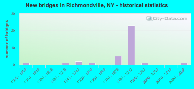
- New bridges - historical statistics
- 11900-1909
- 11930-1939
- 21940-1949
- 11950-1959
- 51970-1979
- 231980-1989
- 11990-1999
- 12020-2022

- Reconstructed bridges - Historical Statistics
- 21950-1959
- 01960-1969
- 01970-1979
- 01980-1989
- 01990-1999
- 12000-2009


- Bridge Condition - Deck
- 13.0%Excellent
- 56.5%Good
- 17.4%Satisfactory
- 8.7%Fair
- 4.3%Poor

- Bridge Condition - Superstructure
- 13.0%Excellent
- 60.9%Good
- 13.0%Satisfactory
- 13.0%Fair

- Bridge Condition - Substructure
- 13.0%Excellent
- 4.3%Very good
- 43.5%Good
- 21.7%Satisfactory
- 17.4%Fair

- Bridge Condition - Channel
- 11.1%Very good
- 66.7%Good
- 11.1%Satisfactory
- 11.1%Fair

- Bridge Condition - Culverts
- 50.0%Good
- 50.0%Fair
Find on map >> Show street view
Structure Number: 100406, Location: 1.2 MI E OF OTSEGO CL (Lat: 42.651981, Lng: -74.611381), Route carried "on" structure: State highway 7, Year Built: 1934, Year Reconstructed: 1961, Status: Open, Structure Length: 0.94m (3.08ft), Average Daily Traffic: 1,650 (year 2020), Truck Traffic: 7%, Average Future Daily Traffic: 1,721 (year 2040), Features Intersected: BR COBLESKILL CRK
Minimum Vertical Clearance: 30+ m (98+ ft), Kilometerpoint: 2.011, Lanes on structure: 2, Base Highway Network: Yes, Owner: State Highway Agency, Approaching Roadway Width: 11.3m (37.1ft), Skew: 3 degrees, Material/Design: Concrete, Design/Construction: Slab, Number Of Spans In Main Unit: 1, Length of Maximum Span: 7.0m (23.0ft), Curb-To-Curb Width: 11.4m (37.4ft), Out-to-Out Width: 11.9m (39.0ft)
Condition: Deck: Satisfactory, Superstructure: Satisfactory, Substructure: Fair, Channel: Good, Operating Rating: 68.0 metric tons, Method Used To Determine Operating Rating: Load Factor (LF), Inventory Rating: 40.8 metric tons, Method Used To Determine Inventory Rating: Load Factor (LF), Structural Evaluation: Somewhat better than minimum adequacy, Deck Geometry: Equal to present minimum criteria, Waterway Adequacy: Meets minimum limits, Approach Roadway Alignment: Equal to present desirable criteria, Length Of Structure Improvement: 0.94m (3.08ft), Designated Inspection Frequency: Every 24 months, Inspection Date: May 2021, Bridge Improvement Cost: $457,000, Roadway Improvement Cost: $268,000, Total Project Cost: $725,000 ( Estimate for 2021), Wearing Surface/Protective System: Wearing Surface: Bituminous
Find on map >> Show street view
Structure Number: 100407, Location: .7 MI E OF RICHMONDVILLE (Lat: 42.643661, Lng: -74.535686), Route carried "on" structure: State highway 7, Year Built: 1997, Status: Open, Structure Length: 1.58m (5.18ft), Average Daily Traffic: 4,838 (year 2019), Truck Traffic: 6%, Average Future Daily Traffic: 5,877 (year 2040), Design Load: HS 25 or greater, Features Intersected: BEARDS HOLLOW CRK
Minimum Vertical Clearance: 30+ m (98+ ft), Kilometerpoint: 8.978, Lanes on structure: 2, Base Highway Network: Yes, Owner: State Highway Agency, Approaching Roadway Width: 13.1m (43.0ft), Material/Design: Prestressed concrete, Design/Construction: Box Beam or Girders - Multiple, Number Of Spans In Main Unit: 1, Length of Maximum Span: 14.9m (48.9ft), Curb-To-Curb Width: 11.9m (39.0ft), Out-to-Out Width: 12.5m (41.0ft)
Condition: Deck: Good, Superstructure: Good, Substructure: Very good, Channel: Good, Inventory Rating: 59.0 metric tons, Method Used To Determine Inventory Rating: Load Factor (LF), Structural Evaluation: Better than present minimum criteria, Deck Geometry: Somewhat better than minimum adequacy, Waterway Adequacy: Equal to present desirable criteria, Approach Roadway Alignment: Equal to present desirable criteria, Length Of Structure Improvement: 1.58m (5.18ft), Designated Inspection Frequency: Every 24 months, Inspection Date: March 2020, Bridge Improvement Cost: $588,000, Roadway Improvement Cost: $344,000, Total Project Cost: $932,000 ( Estimate for 2021), Wearing Surface/Protective System: Wearing Surface: Bituminous
Find on map >> Show street view
Structure Number: 100786, Location: OLD STATE HWY 10 (Lat: 42.628256, Lng: -74.565556), Route carried "on" structure: Other road , Year Built: 1906, Year Reconstructed: 1957, Status: Posted for load, Structure Length: 0.76m (2.49ft), Average Daily Traffic: 161 (year 2019), Truck Traffic: 7%, Average Future Daily Traffic: 225 (year 2039), Features Intersected: BEAR GULCH CREEK, Facility Carried by Structure: OLD SH 10 SUMMIT
Minimum Vertical Clearance: 30+ m (98+ ft), Kilometerpoint: 0.579, Lanes on structure: 2, Owner: County Highway Agency, Approaching Roadway Width: 8.5m (27.9ft), Skew: 3 degrees, Material/Design: Steel, Design/Construction: Stringer/Multi-beam, Number Of Spans In Main Unit: 1, Length of Maximum Span: 6.4m (21.0ft), Curb-To-Curb Width: 10.4m (34.1ft), Out-to-Out Width: 11.3m (37.1ft)
Condition: Deck: Satisfactory, Superstructure: Fair, Substructure: Fair, Channel: Fair, Operating Rating: 41.7 metric tons, Method Used To Determine Operating Rating: Allowable Stress (AS), Inventory Rating: 24.5 metric tons, Method Used To Determine Inventory Rating: Allowable Stress (AS), Structural Evaluation: Somewhat better than minimum adequacy, Deck Geometry: Better than present minimum criteria, Waterway Adequacy: Equal to present desirable criteria, Approach Roadway Alignment: Equal to present minimum criteria, Bridge Posting: Required (Relationship of Operating Rating to Maximum Legal Load: > 39.9% below), Length Of Structure Improvement: 0.76m (2.49ft), Designated Inspection Frequency: Every 12 months, Inspection Date: March 2021, Bridge Improvement Cost: $538,000, Roadway Improvement Cost: $315,000, Total Project Cost: $853,000 ( Estimate for 2021), Deck Structure Type: Concrete Cast-file-Place, Wearing Surface/Protective System: Wearing Surface: Bituminous
Find on map >> Show street view
Structure Number: 1069981, Location: VILLAGE OF RICHMONDVILLE (Lat: 42.638253, Lng: -74.555458), Route carried "on" structure: Interstate 88, Year Built: 1980, Year Reconstructed: 2021, Status: Open, Structure Length: 3.17m (10.40ft), Average Daily Traffic: 4,525 (year 2014), Truck Traffic: 31%, Design Load: HL 93, Features Intersected: COBLESKILL CREEK
Minimum Vertical Clearance: 30+ m (98+ ft), Kilometerpoint: 6.854, Lanes on structure: 2, Base Highway Network: Yes, Owner: State Highway Agency, Approaching Roadway Width: 12.5m (41.0ft), Skew: 2 degrees, Material/Design: Steel, Design/Construction: Stringer/Multi-beam, Number Of Spans In Main Unit: 1, Length of Maximum Span: 30.5m (100.1ft), Curb-To-Curb Width: 12.6m (41.3ft), Out-to-Out Width: 13.6m (44.6ft)
Condition: Deck: Excellent, Superstructure: Excellent, Substructure: Excellent, Channel: Very good, Operating Rating: 77.1 metric tons, Method Used To Determine Operating Rating: Load Factor (LF), Inventory Rating: 46.3 metric tons, Method Used To Determine Inventory Rating: Load Factor (LF), Structural Evaluation: Superior to present desirable criteria, Deck Geometry: Better than present minimum criteria, Waterway Adequacy: Meets minimum limits, Approach Roadway Alignment: Equal to present desirable criteria, Length Of Structure Improvement: 3.20m (10.50ft), Designated Inspection Frequency: Every 24 months, Inspection Date: November 2021, Bridge Improvement Cost: $1,160,000, Roadway Improvement Cost: $679,000, Total Project Cost: $1,839,000 ( Estimate for 2021), Deck Structure Type: Concrete Cast-file-Place, Wearing Surface/Protective System: Wearing Surface: Integral Concrete, Deck Protection: Epoxy Coated Reinforcing
Find on map >> Show street view
Structure Number: 1069982, Location: VILLAGE OF RICHMONDVILLE (Lat: 42.638058, Lng: -74.555267), Route carried "on" structure: Interstate 88, Year Built: 1980, Status: Open, Structure Length: 3.17m (10.40ft), Average Daily Traffic: 3,807 (year 2019), Truck Traffic: 28%, Average Future Daily Traffic: 5,007 (year 2040), Design Load: HS 20, Features Intersected: COBLESKILL CREEK
Minimum Vertical Clearance: 30+ m (98+ ft), Kilometerpoint: 6.838, Lanes on structure: 2, Base Highway Network: Yes, Owner: State Highway Agency, Approaching Roadway Width: 12.2m (40.0ft), Material/Design: Prestressed concrete, Design/Construction: Box Beam or Girders - Multiple, Number Of Spans In Main Unit: 1, Length of Maximum Span: 30.4m (99.7ft), Curb-To-Curb Width: 12.9m (42.3ft), Out-to-Out Width: 13.5m (44.3ft)
Condition: Deck: Fair, Superstructure: Fair, Substructure: Satisfactory, Channel: Satisfactory, Operating Rating: 70.8 metric tons, Method Used To Determine Operating Rating: Load Factor (LF), Inventory Rating: 41.7 metric tons, Method Used To Determine Inventory Rating: Load Factor (LF), Structural Evaluation: Somewhat better than minimum adequacy, Deck Geometry: Superior to present desirable criteria, Waterway Adequacy: Equal to present minimum criteria, Approach Roadway Alignment: Equal to present desirable criteria, Length Of Structure Improvement: 3.16m (10.37ft), Designated Inspection Frequency: Every 24 months, Inspection Date: May 2021, Bridge Improvement Cost: $1,111,000, Roadway Improvement Cost: $651,000, Total Project Cost: $1,762,000 ( Estimate for 2021), Wearing Surface/Protective System: Wearing Surface: Monolithic Concrete
Find on map >> Show street view
Structure Number: 1069999, Location: E VIL LI OF RICHMONDVILLE (Lat: 42.641175, Lng: -74.546936), Route carried "on" structure: Ramp Interstate 992K, Year Built: 1980, Status: Open, Structure Length: 7.74m (25.39ft), Average Daily Traffic: 837 (year 2020), Truck Traffic: 12%, Average Future Daily Traffic: 1,016 (year 2040), Design Load: HS 20, Features Intersected: 88I 88I95071047 WB, RTE
Minimum Vertical Clearance: 30+ m (98+ ft), Kilometerpoint: 0.193, Lanes on structure: 2, Lanes under structure: 5, Owner: State Highway Agency, Approaching Roadway Width: 15.5m (50.9ft), Skew: 32 degrees, Material/Design: Steel, Design/Construction: Stringer/Multi-beam, Number Of Spans In Main Unit: 2, Length of Maximum Span: 38.7m (127.0ft), Curb-To-Curb Width: 15.2m (49.9ft), Out-to-Out Width: 16.2m (53.1ft)
Condition: Deck: Good, Superstructure: Good, Substructure: Satisfactory, Operating Rating: 74.8 metric tons, Method Used To Determine Operating Rating: Load and Resistance Factor Rating (LRFR) rating reported by rating factor(RF) method using HL-93 loadings, Inventory Rating: 57.7 metric tons, Method Used To Determine Inventory Rating: Load and Resistance Factor Rating (LRFR) rating reported by rating factor(RF) method using HL-93 loadings, Structural Evaluation: Equal to present minimum criteria, Deck Geometry: Superior to present desirable criteria, Underclear: Equal to present minimum criteria, Approach Roadway Alignment: Equal to present desirable criteria, Length Of Structure Improvement: 7.74m (25.39ft), Designated Inspection Frequency: Every 24 months, Inspection Date: May 2021, Bridge Improvement Cost: $3,140,000, Roadway Improvement Cost: $1,839,000, Total Project Cost: $4,978,000 ( Estimate for 2021), Deck Structure Type: Concrete Cast-file-Place, Wearing Surface/Protective System: Wearing Surface: Integral Concrete, Deck Protection: Epoxy Coated Reinforcing
Find on map >> Show street view
Structure Number: 1070001, Location: .3 MI E OF RICHMONDVILLE (Lat: 42.642600, Lng: -74.542808), Route carried "on" structure: Interstate 88, Year Built: 1980, Status: Open, Structure Length: 3.20m (10.50ft), Average Daily Traffic: 6,227 (year 2008), Truck Traffic: 24%, Average Future Daily Traffic: 8,718 (year 2028), Design Load: HS 20, Features Intersected: COBLESKILL CREEK
Minimum Vertical Clearance: 30+ m (98+ ft), Kilometerpoint: 7.965, Lanes on structure: 2, Base Highway Network: Yes, Owner: State Highway Agency, Approaching Roadway Width: 12.8m (42.0ft), Skew: 2 degrees, Material/Design: Steel, Design/Construction: Stringer/Multi-beam, Number Of Spans In Main Unit: 1, Length of Maximum Span: 30.4m (99.7ft), Curb-To-Curb Width: 12.8m (42.0ft), Out-to-Out Width: 13.4m (44.0ft)
Condition: Deck: Good, Superstructure: Good, Substructure: Satisfactory, Channel: Good, Operating Rating: 96.2 metric tons, Method Used To Determine Operating Rating: Load Factor (LF), Inventory Rating: 57.2 metric tons, Method Used To Determine Inventory Rating: Load Factor (LF), Structural Evaluation: Equal to present minimum criteria, Deck Geometry: Equal to present desirable criteria, Waterway Adequacy: Equal to present minimum criteria, Approach Roadway Alignment: Equal to present desirable criteria, Length Of Structure Improvement: 3.20m (10.50ft), Designated Inspection Frequency: Every 24 months, Inspection Date: September 2020, Bridge Improvement Cost: $1,170,000, Roadway Improvement Cost: $685,000, Total Project Cost: $1,855,000 ( Estimate for 2021), Deck Structure Type: Concrete Cast-file-Place, Wearing Surface/Protective System: Wearing Surface: Integral Concrete, Deck Protection: Epoxy Coated Reinforcing
Find on map >> Show street view
Structure Number: 1070002, Location: .3 MI E OF RICHMONDVILLE (Lat: 42.642314, Lng: -74.542825), Route carried "on" structure: Ramp Interstate 88, Year Built: 1980, Status: Open, Structure Length: 3.78m (12.40ft), Average Daily Traffic: 3,930 (year 2020), Truck Traffic: 33%, Average Future Daily Traffic: 5,169 (year 2040), Design Load: HS 20, Features Intersected: COBLESKILL CREEK
Minimum Vertical Clearance: 30+ m (98+ ft), Kilometerpoint: 7.948, Lanes on structure: 3, Base Highway Network: Yes, Owner: State Highway Agency, Approaching Roadway Width: 17.7m (58.1ft), Skew: 2 degrees, Material/Design: Steel, Design/Construction: Stringer/Multi-beam, Number Of Spans In Main Unit: 1, Length of Maximum Span: 36.2m (118.8ft), Curb-To-Curb Width: 16.7m (54.8ft), Out-to-Out Width: 17.3m (56.8ft)
Condition: Deck: Satisfactory, Superstructure: Good, Substructure: Satisfactory, Channel: Good, Operating Rating: 92.5 metric tons, Method Used To Determine Operating Rating: Load Factor (LF), Inventory Rating: 55.3 metric tons, Method Used To Determine Inventory Rating: Load Factor (LF), Structural Evaluation: Equal to present minimum criteria, Deck Geometry: Superior to present desirable criteria, Waterway Adequacy: High priority of replacement, Approach Roadway Alignment: Equal to present desirable criteria, Length Of Structure Improvement: 3.77m (12.37ft), Designated Inspection Frequency: Every 24 months, Inspection Date: September 2020, Bridge Improvement Cost: $1,873,000, Roadway Improvement Cost: $1,097,000, Total Project Cost: $2,969,000 ( Estimate for 2021), Deck Structure Type: Concrete Cast-file-Place, Wearing Surface/Protective System: Wearing Surface: Integral Concrete, Deck Protection: Epoxy Coated Reinforcing
Find on map >> Show street view
Structure Number: 107002, Location: .3 MI E OF RICHMONDVILLE (Lat: 42.643111, Lng: -74.542883), Route carried "on" structure: Ramp Interstate 88, Year Built: 1980, Year Reconstructed: 2021, Status: Open, Structure Length: 3.26m (10.70ft), Average Daily Traffic: 720 (year 2018), Truck Traffic: 23%, Average Future Daily Traffic: 947 (year 2040), Design Load: HL 93, Features Intersected: COBLESKILL CREEK
Minimum Vertical Clearance: 30+ m (98+ ft), Kilometerpoint: 0.322, Lanes on structure: 1, Owner: State Highway Agency, Approaching Roadway Width: 7.6m (24.9ft), Material/Design: Steel, Design/Construction: Stringer/Multi-beam, Number Of Spans In Main Unit: 1, Length of Maximum Span: 31.3m (102.7ft), Curb-To-Curb Width: 7.3m (24.0ft), Out-to-Out Width: 8.4m (27.6ft)
Condition: Deck: Excellent, Superstructure: Excellent, Substructure: Excellent, Channel: Very good, Operating Rating: 78.9 metric tons, Method Used To Determine Operating Rating: Load Factor (LF), Inventory Rating: 35.4 metric tons, Method Used To Determine Inventory Rating: Load Factor (LF), Structural Evaluation: Superior to present desirable criteria, Deck Geometry: Better than present minimum criteria, Waterway Adequacy: Equal to present minimum criteria, Approach Roadway Alignment: Equal to present desirable criteria, Length Of Structure Improvement: 3.26m (10.70ft), Designated Inspection Frequency: Every 24 months, Inspection Date: November 2021, Bridge Improvement Cost: $676,000, Roadway Improvement Cost: $396,000, Total Project Cost: $1,072,000 ( Estimate for 2021), Deck Structure Type: Concrete Cast-file-Place, Wearing Surface/Protective System: Wearing Surface: Integral Concrete, Deck Protection: Epoxy Coated Reinforcing
Find on map >> Show street view
Structure Number: 107018, Location: .7 MI E OF RICHMONDVILLE (Lat: 42.644692, Lng: -74.536764), Route carried "on" structure: Interstate 88, Year Built: 1980, Status: Open, Structure Length: 0.73m (2.40ft), Average Daily Traffic: 9,813 (year 2018), Truck Traffic: 24%, Average Future Daily Traffic: 9,911 (year 2039), Design Load: HS 20, Features Intersected: BEARDS HOLLOW CRK
Minimum Vertical Clearance: 30+ m (98+ ft), Kilometerpoint: 8.544, Lanes on structure: 2, Base Highway Network: Yes, Owner: State Highway Agency, Approaching Roadway Width: 12.8m (42.0ft), Material/Design: Steel, Design/Construction: Culvert, Number Of Spans In Main Unit: 1, Length of Maximum Span: 7.0m (23.0ft)
Condition: Channel: Satisfactory, Culverts: Fair, Operating Rating: 77.6 metric tons, Method Used To Determine Operating Rating: Field evaluation and documented engineering judgment, Inventory Rating: 32.7 metric tons, Method Used To Determine Inventory Rating: Field evaluation and documented engineering judgment, Structural Evaluation: Somewhat better than minimum adequacy, Waterway Adequacy: Meets minimum limits, Approach Roadway Alignment: Equal to present desirable criteria, Length Of Structure Improvement: 0.73m (2.40ft), Designated Inspection Frequency: Every 12 months, Inspection Date: August 2021, Bridge Improvement Cost: $332,000, Roadway Improvement Cost: $194,000, Total Project Cost: $526,000 ( Estimate for 2021)
Find on map >> Show street view
Structure Number: 1070181, Location: .7 MI E OF RICHMONDVILLE (Lat: 42.644708, Lng: -74.536764), Route carried "on" structure: Interstate 88, Year Built: 2021, Status: Open, Structure Length: 2.56m (8.40ft), Average Daily Traffic: 3,930 (year 2020), Truck Traffic: 33%, Average Future Daily Traffic: 5,169 (year 2040), Design Load: HL 93, Features Intersected: BEARDS HOLLOW CRK
Minimum Vertical Clearance: 32.69m (107.25ft), Kilometerpoint: 8.560, Lanes on structure: 3, Owner: State Highway Agency, Approaching Roadway Width: 15.8m (51.8ft), Skew: 1 degrees, Material/Design: Steel, Design/Construction: Stringer/Multi-beam, Number Of Spans In Main Unit: 1, Length of Maximum Span: 25.0m (82.0ft), Curb-To-Curb Width: 15.8m (51.8ft), Out-to-Out Width: 16.8m (55.1ft)
Condition: Deck: Excellent, Superstructure: Excellent, Substructure: Excellent, Channel: Good, Operating Rating: 68.0 metric tons, Method Used To Determine Operating Rating: Load Factor (LF), Inventory Rating: 39.9 metric tons, Method Used To Determine Inventory Rating: Load Factor (LF), Structural Evaluation: Superior to present desirable criteria, Deck Geometry: Somewhat better than minimum adequacy, Waterway Adequacy: Meets minimum limits, Approach Roadway Alignment: Equal to present desirable criteria, Length Of Structure Improvement: 2.56m (8.40ft), Designated Inspection Frequency: Every 24 months, Inspection Date: November 2021, Bridge Improvement Cost: $1,136,000, Roadway Improvement Cost: $665,000, Total Project Cost: $1,802,000 ( Estimate for 2020), Deck Structure Type: Concrete Cast-file-Place, Wearing Surface/Protective System: Wearing Surface: Integral Concrete, Deck Protection: Epoxy Coated Reinforcing
Find on map >> Show street view
Structure Number: 1070191, Location: JCT OF SH7 / SH10 & I88 (Lat: 42.646164, Lng: -74.532556), Route carried "on" structure: Interstate 88, Year Built: 1978, Status: Open, Structure Length: 4.69m (15.39ft), Average Daily Traffic: 6,227 (year 2008), Truck Traffic: 24%, Design Load: HS 20+Mod, Features Intersected: RTE 7
Minimum Vertical Clearance: 30+ m (98+ ft), Kilometerpoint: 8.882, Lanes on structure: 2, Lanes under structure: 2, Base Highway Network: Yes, Owner: State Highway Agency, Approaching Roadway Width: 12.2m (40.0ft), Skew: 4 degrees, Material/Design: Steel, Design/Construction: Stringer/Multi-beam, Number Of Spans In Main Unit: 1, Length of Maximum Span: 45.1m (148.0ft), Curb-To-Curb Width: 12.5m (41.0ft), Out-to-Out Width: 13.4m (44.0ft)
Condition: Deck: Good, Superstructure: Satisfactory, Substructure: Good, Operating Rating: 68.4 metric tons, Method Used To Determine Operating Rating: Load and Resistance Factor Rating (LRFR) rating reported by rating factor(RF) method using HL-93 loadings, Inventory Rating: 52.5 metric tons, Method Used To Determine Inventory Rating: Load and Resistance Factor Rating (LRFR) rating reported by rating factor(RF) method using HL-93 loadings, Structural Evaluation: Equal to present minimum criteria, Deck Geometry: Better than present minimum criteria, Underclear: Better than present minimum criteria, Approach Roadway Alignment: Equal to present desirable criteria, Length Of Structure Improvement: 4.69m (15.39ft), Designated Inspection Frequency: Every 24 months, Inspection Date: March 2021, Bridge Improvement Cost: $1,830,000, Roadway Improvement Cost: $1,071,000, Total Project Cost: $2,901,000 ( Estimate for 2021), Deck Structure Type: Concrete Cast-file-Place, Wearing Surface/Protective System: Wearing Surface: Epoxy Overlay, Deck Protection: Epoxy Coated Reinforcing
Find on map >> Show street view
Structure Number: 1070192, Location: JCT OF SH 7 / SH 10 & 88I (Lat: 42.645811, Lng: -74.532731), Route carried "on" structure: Interstate 88, Year Built: 1978, Status: Open, Structure Length: 4.69m (15.39ft), Average Daily Traffic: 3,930 (year 2020), Truck Traffic: 33%, Average Future Daily Traffic: 5,169 (year 2040), Design Load: HS 20+Mod, Features Intersected: RTE 7
Minimum Vertical Clearance: 30+ m (98+ ft), Kilometerpoint: 8.882, Lanes on structure: 2, Lanes under structure: 2, Base Highway Network: Yes, Owner: State Highway Agency, Approaching Roadway Width: 12.2m (40.0ft), Skew: 4 degrees, Material/Design: Steel, Design/Construction: Stringer/Multi-beam, Number Of Spans In Main Unit: 1, Length of Maximum Span: 45.1m (148.0ft), Curb-To-Curb Width: 12.5m (41.0ft), Out-to-Out Width: 13.4m (44.0ft)
Condition: Deck: Good, Superstructure: Satisfactory, Substructure: Good, Operating Rating: 68.4 metric tons, Method Used To Determine Operating Rating: Load and Resistance Factor Rating (LRFR) rating reported by rating factor(RF) method using HL-93 loadings, Inventory Rating: 52.5 metric tons, Method Used To Determine Inventory Rating: Load and Resistance Factor Rating (LRFR) rating reported by rating factor(RF) method using HL-93 loadings, Structural Evaluation: Equal to present minimum criteria, Deck Geometry: Better than present minimum criteria, Underclear: Equal to present minimum criteria, Approach Roadway Alignment: Equal to present desirable criteria, Length Of Structure Improvement: 4.69m (15.39ft), Designated Inspection Frequency: Every 24 months, Inspection Date: March 2021, Bridge Improvement Cost: $1,874,000, Roadway Improvement Cost: $1,098,000, Total Project Cost: $2,972,000 ( Estimate for 2021), Deck Structure Type: Concrete Cast-file-Place, Wearing Surface/Protective System: Wearing Surface: Epoxy Overlay, Deck Protection: Epoxy Coated Reinforcing
Find on map >> Show street view
Structure Number: 1070551, Location: 2.5 MI W OF RICHMONDVILLE (Lat: 42.649825, Lng: -74.623478), Route carried "on" structure: Interstate 88, Year Built: 1980, Status: Open, Structure Length: 3.38m (11.09ft), Average Daily Traffic: 4,525 (year 2014), Truck Traffic: 31%, Average Future Daily Traffic: 6,334 (year 2034), Design Load: HS 20, Features Intersected: SMITH ROAD
Minimum Vertical Clearance: 30+ m (98+ ft), Kilometerpoint: 0.917, Lanes on structure: 2, Lanes under structure: 1, Base Highway Network: Yes, Owner: State Highway Agency, Approaching Roadway Width: 12.5m (41.0ft), Material/Design: Steel, Design/Construction: Stringer/Multi-beam, Number Of Spans In Main Unit: 1, Length of Maximum Span: 32.3m (106.0ft), Curb-To-Curb Width: 12.5m (41.0ft), Out-to-Out Width: 13.4m (44.0ft)
Condition: Deck: Fair, Superstructure: Good, Substructure: Good, Inventory Rating: 61.7 metric tons, Method Used To Determine Inventory Rating: Load Factor (LF), Structural Evaluation: Better than present minimum criteria, Deck Geometry: Better than present minimum criteria, Underclear: High priority of corrective action, Approach Roadway Alignment: Equal to present desirable criteria, Length Of Structure Improvement: 3.38m (11.09ft), Designated Inspection Frequency: Every 24 months, Inspection Date: October 2020, Bridge Improvement Cost: $1,273,000, Roadway Improvement Cost: $746,000, Total Project Cost: $2,019,000 ( Estimate for 2021), Deck Structure Type: Concrete Cast-file-Place, Wearing Surface/Protective System: Wearing Surface: Monolithic Concrete, Deck Protection: Epoxy Coated Reinforcing
Find on map >> Show street view
Structure Number: 1070552, Location: 2.5 MI W OF RICHMONDVILLE (Lat: 42.649369, Lng: -74.623683), Route carried "on" structure: Interstate 88, Year Built: 1980, Status: Open, Structure Length: 3.57m (11.71ft), Average Daily Traffic: 3,807 (year 2019), Truck Traffic: 28%, Average Future Daily Traffic: 4,534 (year 2040), Design Load: HS 20, Features Intersected: SMITH ROAD
Minimum Vertical Clearance: 30+ m (98+ ft), Kilometerpoint: 0.917, Lanes on structure: 2, Lanes under structure: 1, Base Highway Network: Yes, Owner: State Highway Agency, Approaching Roadway Width: 12.5m (41.0ft), Material/Design: Steel, Design/Construction: Stringer/Multi-beam, Number Of Spans In Main Unit: 1, Length of Maximum Span: 34.1m (111.9ft), Curb-To-Curb Width: 12.5m (41.0ft), Out-to-Out Width: 13.4m (44.0ft)
Condition: Deck: Good, Superstructure: Good, Substructure: Satisfactory, Inventory Rating: 74.4 metric tons, Method Used To Determine Inventory Rating: Load Factor (LF), Structural Evaluation: Equal to present minimum criteria, Deck Geometry: Better than present minimum criteria, Underclear: Meets minimum limits, Approach Roadway Alignment: Equal to present desirable criteria, Length Of Structure Improvement: 3.56m (11.68ft), Designated Inspection Frequency: Every 24 months, Inspection Date: October 2020, Bridge Improvement Cost: $1,371,000, Roadway Improvement Cost: $803,000, Total Project Cost: $2,173,000 ( Estimate for 2021), Deck Structure Type: Concrete Cast-file-Place, Wearing Surface/Protective System: Wearing Surface: Bituminous, Deck Protection: Epoxy Coated Reinforcing
Find on map >> Show street view
Structure Number: 1070561, Location: 1 MI W OF RICHMONDVILLE (Lat: 42.644858, Lng: -74.589056), Route carried "on" structure: Interstate 88, Year Built: 1980, Status: Open, Structure Length: 8.81m (28.90ft), Average Daily Traffic: 4,525 (year 2014), Truck Traffic: 31%, Design Load: HS 20, Features Intersected: RTE 7
Minimum Vertical Clearance: 30+ m (98+ ft), Kilometerpoint: 3.878, Lanes on structure: 2, Lanes under structure: 2, Base Highway Network: Yes, Owner: State Highway Agency, Approaching Roadway Width: 12.8m (42.0ft), Skew: 4 degrees, Material/Design: Steel, Design/Construction: Stringer/Multi-beam, Number Of Spans In Main Unit: 3, Length of Maximum Span: 46.9m (153.9ft), Curb-To-Curb Width: 12.5m (41.0ft), Out-to-Out Width: 13.4m (44.0ft)
Condition: Deck: Satisfactory, Superstructure: Good, Substructure: Good, Operating Rating: 50.2 metric tons, Method Used To Determine Operating Rating: Load and Resistance Factor Rating (LRFR) rating reported by rating factor(RF) method using HL-93 loadings, Inventory Rating: 38.6 metric tons, Method Used To Determine Inventory Rating: Load and Resistance Factor Rating (LRFR) rating reported by rating factor(RF) method using HL-93 loadings, Structural Evaluation: Better than present minimum criteria, Deck Geometry: Better than present minimum criteria, Underclear: Equal to present minimum criteria, Approach Roadway Alignment: Equal to present desirable criteria, Length Of Structure Improvement: 8.86m (29.07ft), Designated Inspection Frequency: Every 24 months, Inspection Date: March 2021, Bridge Improvement Cost: $2,970,000, Roadway Improvement Cost: $1,739,000, Total Project Cost: $4,710,000 ( Estimate for 2021), Deck Structure Type: Concrete Cast-file-Place, Wearing Surface/Protective System: Wearing Surface: Epoxy Overlay, Deck Protection: Epoxy Coated Reinforcing
Find on map >> Show street view
Structure Number: 1070562, Location: 1 MI W OF RICHMONDVILLE (Lat: 42.644417, Lng: -74.588661), Route carried "on" structure: Interstate 88, Year Built: 1980, Status: Open, Structure Length: 9.45m (31.00ft), Average Daily Traffic: 3,807 (year 2019), Truck Traffic: 28%, Average Future Daily Traffic: 5,007 (year 2040), Design Load: HS 20, Features Intersected: RTE 7
Minimum Vertical Clearance: 30+ m (98+ ft), Kilometerpoint: 3.878, Lanes on structure: 2, Lanes under structure: 2, Base Highway Network: Yes, Owner: State Highway Agency, Approaching Roadway Width: 12.8m (42.0ft), Skew: 4 degrees, Material/Design: Steel, Design/Construction: Stringer/Multi-beam, Number Of Spans In Main Unit: 3, Length of Maximum Span: 48.1m (157.8ft), Curb-To-Curb Width: 12.5m (41.0ft), Out-to-Out Width: 13.4m (44.0ft)
Condition: Deck: Good, Superstructure: Good, Substructure: Good, Operating Rating: 57.3 metric tons, Method Used To Determine Operating Rating: Load and Resistance Factor Rating (LRFR) rating reported by rating factor(RF) method using HL-93 loadings, Inventory Rating: 44.4 metric tons, Method Used To Determine Inventory Rating: Load and Resistance Factor Rating (LRFR) rating reported by rating factor(RF) method using HL-93 loadings, Structural Evaluation: Better than present minimum criteria, Deck Geometry: Better than present minimum criteria, Underclear: Equal to present minimum criteria, Approach Roadway Alignment: Equal to present desirable criteria, Length Of Structure Improvement: 9.54m (31.30ft), Designated Inspection Frequency: Every 24 months, Inspection Date: March 2021, Bridge Improvement Cost: $3,125,000, Roadway Improvement Cost: $1,830,000, Total Project Cost: $4,955,000 ( Estimate for 2021), Deck Structure Type: Concrete Cast-file-Place, Wearing Surface/Protective System: Wearing Surface: Epoxy Overlay, Deck Protection: Epoxy Coated Reinforcing
Find on map >> Show street view
Structure Number: 1070571, Location: VILLAGE OF RICHMONDVILLE (Lat: 42.639111, Lng: -74.573736), Route carried "on" structure: Interstate 88, Year Built: 1980, Status: Open, Structure Length: 4.69m (15.39ft), Average Daily Traffic: 4,525 (year 2014), Truck Traffic: 31%, Design Load: HS 20, Features Intersected: COBLESKILL CREEK
Minimum Vertical Clearance: 30+ m (98+ ft), Kilometerpoint: 5.278, Lanes on structure: 2, Base Highway Network: Yes, Owner: State Highway Agency, Approaching Roadway Width: 12.8m (42.0ft), Skew: 4 degrees, Material/Design: Steel, Design/Construction: Stringer/Multi-beam, Number Of Spans In Main Unit: 1, Length of Maximum Span: 45.1m (148.0ft), Curb-To-Curb Width: 12.8m (42.0ft), Out-to-Out Width: 13.4m (44.0ft)
Condition: Deck: Good, Superstructure: Good, Substructure: Good, Channel: Good, Inventory Rating: 77.1 metric tons, Method Used To Determine Inventory Rating: Load Factor (LF), Structural Evaluation: Better than present minimum criteria, Deck Geometry: Equal to present desirable criteria, Waterway Adequacy: High priority of replacement, Approach Roadway Alignment: Equal to present desirable criteria, Length Of Structure Improvement: 4.69m (15.39ft), Designated Inspection Frequency: Every 24 months, Inspection Date: August 2021, Bridge Improvement Cost: $1,885,000, Roadway Improvement Cost: $1,104,000, Total Project Cost: $2,989,000 ( Estimate for 2021), Deck Structure Type: Concrete Cast-file-Place, Wearing Surface/Protective System: Wearing Surface: Epoxy Overlay, Deck Protection: Epoxy Coated Reinforcing
Find on map >> Show street view
Structure Number: 1070572, Location: VILLAGE OF RICHMONDVILLE (Lat: 42.638803, Lng: -74.573642), Route carried "on" structure: Interstate 88, Year Built: 1980, Status: Open, Structure Length: 4.69m (15.39ft), Average Daily Traffic: 3,807 (year 2019), Truck Traffic: 28%, Average Future Daily Traffic: 5,007 (year 2040), Design Load: HS 20, Features Intersected: COBLESKILL CREEK
Minimum Vertical Clearance: 30+ m (98+ ft), Kilometerpoint: 5.278, Lanes on structure: 2, Base Highway Network: Yes, Owner: State Highway Agency, Approaching Roadway Width: 12.8m (42.0ft), Skew: 4 degrees, Material/Design: Steel, Design/Construction: Stringer/Multi-beam, Number Of Spans In Main Unit: 1, Length of Maximum Span: 45.1m (148.0ft), Curb-To-Curb Width: 12.8m (42.0ft), Out-to-Out Width: 13.4m (44.0ft)
Condition: Deck: Good, Superstructure: Good, Substructure: Good, Channel: Good, Inventory Rating: 77.1 metric tons, Method Used To Determine Inventory Rating: Load Factor (LF), Structural Evaluation: Better than present minimum criteria, Deck Geometry: Equal to present desirable criteria, Waterway Adequacy: Equal to present minimum criteria, Approach Roadway Alignment: Equal to present desirable criteria, Length Of Structure Improvement: 4.69m (15.39ft), Designated Inspection Frequency: Every 24 months, Inspection Date: August 2021, Bridge Improvement Cost: $1,931,000, Roadway Improvement Cost: $1,131,000, Total Project Cost: $3,062,000 ( Estimate for 2021), Deck Structure Type: Concrete Cast-file-Place, Wearing Surface/Protective System: Wearing Surface: Epoxy Overlay, Deck Protection: Epoxy Coated Reinforcing
Find on map >> Show street view
Structure Number: 107058, Location: VILLAGE OF RICHMONDVILLE (Lat: 42.638783, Lng: -74.572864), Route carried "on" structure: ServiceCity street , Year Built: 1980, Status: Open, Structure Length: 10.55m (34.61ft), Average Daily Traffic: 273 (year 2019), Truck Traffic: 7%, Average Future Daily Traffic: 382 (year 2039), Design Load: HS 20, Features Intersected: RTE I88, COBLESKILL CREE, Facility Carried by Structure: RELOCATED MILL ST
Minimum Vertical Clearance: 30+ m (98+ ft), Kilometerpoint: 0.048, Lanes on structure: 2, Lanes under structure: 4, Owner: State Highway Agency, Approaching Roadway Width: 6.1m (20.0ft), Material/Design: Steel continuous, Design/Construction: Stringer/Multi-beam, Number Of Spans In Main Unit: 3, Length of Maximum Span: 36.5m (119.8ft), Curb-To-Curb Width: 8.2m (26.9ft), Out-to-Out Width: 9.1m (29.9ft)
Condition: Deck: Good, Superstructure: Good, Substructure: Good, Channel: Good, Operating Rating: 78.9 metric tons, Method Used To Determine Operating Rating: Load Factor (LF), Inventory Rating: 47.2 metric tons, Method Used To Determine Inventory Rating: Load Factor (LF), Structural Evaluation: Better than present minimum criteria, Deck Geometry: Somewhat better than minimum adequacy, Underclear: Somewhat better than minimum adequacy, Waterway Adequacy: Equal to present minimum criteria, Approach Roadway Alignment: Equal to present desirable criteria, Length Of Structure Improvement: 10.54m (34.58ft), Designated Inspection Frequency: Every 24 months, Inspection Date: June 2021, Bridge Improvement Cost: $2,249,000, Roadway Improvement Cost: $1,317,000, Total Project Cost: $3,567,000 ( Estimate for 2021), Deck Structure Type: Concrete Cast-file-Place, Wearing Surface/Protective System: Wearing Surface: Integral Concrete, Deck Protection: Epoxy Coated Reinforcing
Find on map >> Show street view
Structure Number: 1070591, Location: VILLAGE OF RICHMONDVILLE (Lat: 42.637803, Lng: -74.569917), Route carried "on" structure: Interstate 88, Year Built: 1980, Status: Open, Structure Length: 4.21m (13.81ft), Average Daily Traffic: 4,525 (year 2014), Truck Traffic: 31%, Design Load: HS 20, Features Intersected: COBLESKILL CREEK
Minimum Vertical Clearance: 30+ m (98+ ft), Kilometerpoint: 5.583, Lanes on structure: 2, Base Highway Network: Yes, Owner: State Highway Agency, Approaching Roadway Width: 12.8m (42.0ft), Skew: 4 degrees, Material/Design: Steel, Design/Construction: Stringer/Multi-beam, Number Of Spans In Main Unit: 1, Length of Maximum Span: 40.2m (131.9ft), Curb-To-Curb Width: 12.8m (42.0ft), Out-to-Out Width: 13.4m (44.0ft)
Condition: Deck: Good, Superstructure: Good, Substructure: Good, Channel: Good, Operating Rating: 95.3 metric tons, Method Used To Determine Operating Rating: Load Factor (LF), Inventory Rating: 57.2 metric tons, Method Used To Determine Inventory Rating: Load Factor (LF), Structural Evaluation: Better than present minimum criteria, Deck Geometry: Equal to present desirable criteria, Waterway Adequacy: Equal to present minimum criteria, Approach Roadway Alignment: Equal to present desirable criteria, Length Of Structure Improvement: 4.20m (13.78ft), Designated Inspection Frequency: Every 24 months, Inspection Date: August 2021, Bridge Improvement Cost: $1,716,000, Roadway Improvement Cost: $1,005,000, Total Project Cost: $2,720,000 ( Estimate for 2021), Deck Structure Type: Concrete Cast-file-Place, Wearing Surface/Protective System: Wearing Surface: Epoxy Overlay, Deck Protection: Epoxy Coated Reinforcing
Find on map >> Show street view
Structure Number: 1070592, Location: VILLAGE OF RICHMONDVILLE (Lat: 42.637681, Lng: -74.570253), Route carried "on" structure: Interstate 88, Year Built: 1980, Status: Open, Structure Length: 4.33m (14.21ft), Average Daily Traffic: 3,807 (year 2019), Truck Traffic: 28%, Average Future Daily Traffic: 5,007 (year 2040), Design Load: HS 20, Features Intersected: COBLESKILL CREEK
Minimum Vertical Clearance: 30+ m (98+ ft), Kilometerpoint: 5.567, Lanes on structure: 2, Base Highway Network: Yes, Owner: State Highway Agency, Approaching Roadway Width: 12.8m (42.0ft), Skew: 4 degrees, Material/Design: Steel, Design/Construction: Stringer/Multi-beam, Number Of Spans In Main Unit: 1, Length of Maximum Span: 41.4m (135.8ft), Curb-To-Curb Width: 12.8m (42.0ft), Out-to-Out Width: 13.4m (44.0ft)
Condition: Deck: Good, Superstructure: Good, Substructure: Good, Channel: Good, Inventory Rating: 68.0 metric tons, Method Used To Determine Inventory Rating: Load Factor (LF), Structural Evaluation: Better than present minimum criteria, Deck Geometry: Equal to present desirable criteria, Waterway Adequacy: Equal to present minimum criteria, Approach Roadway Alignment: Equal to present desirable criteria, Length Of Structure Improvement: 4.32m (14.17ft), Designated Inspection Frequency: Every 24 months, Inspection Date: August 2021, Bridge Improvement Cost: $1,748,000, Roadway Improvement Cost: $1,024,000, Total Project Cost: $2,771,000 ( Estimate for 2021), Deck Structure Type: Concrete Cast-file-Place, Wearing Surface/Protective System: Wearing Surface: Epoxy Overlay, Deck Protection: Epoxy Coated Reinforcing
Find on map >> Show street view
Structure Number: 1070609, Location: VILLAGE OF RICHMONDVILLE (Lat: 42.637356, Lng: -74.567681), Route carried "on" structure: Interstate 88, Year Built: 1980, Status: Open, Structure Length: 0.64m (2.10ft), Average Daily Traffic: 7,614 (year 2019), Truck Traffic: 28%, Average Future Daily Traffic: 10,015 (year 2040), Design Load: HS 20, Features Intersected: BROOKER HOLLW CRK
Minimum Vertical Clearance: 30+ m (98+ ft), Kilometerpoint: 5.808, Lanes on structure: 4, Base Highway Network: Yes, Owner: State Highway Agency, Approaching Roadway Width: 23.2m (76.1ft), Skew: 20 degrees, Material/Design: Steel, Design/Construction: Culvert, Number Of Spans In Main Unit: 1, Length of Maximum Span: 6.0m (19.7ft)
Condition: Channel: Good, Culverts: Good, Operating Rating: 76.9 metric tons, Method Used To Determine Operating Rating: Field evaluation and documented engineering judgment, Inventory Rating: 32.7 metric tons, Method Used To Determine Inventory Rating: Field evaluation and documented engineering judgment, Structural Evaluation: Better than present minimum criteria, Waterway Adequacy: Equal to present minimum criteria, Approach Roadway Alignment: Equal to present desirable criteria, Length Of Structure Improvement: 0.64m (2.10ft), Designated Inspection Frequency: Every 24 months, Inspection Date: November 2020, Bridge Improvement Cost: $262,000, Roadway Improvement Cost: $154,000, Total Project Cost: $416,000 ( Estimate for 2021)
Find on map >> Show street view
Structure Number: 222863, Location: 1.8 MI NE OF RICHMONDVLLE (Lat: 42.648639, Lng: -74.537408), Route carried "on" structure: Other road , Year Built: 1978, Year Reconstructed: 2009, Status: Open, Structure Length: 2.07m (6.79ft), Average Daily Traffic: 128 (year 2019), Truck Traffic: 7%, Average Future Daily Traffic: 179 (year 2039), Design Load: H 20, Features Intersected: COBLESKILL CREEK, Facility Carried by Structure: PODPADIC ROAD
Minimum Vertical Clearance: 30+ m (98+ ft), Kilometerpoint: 0.483, Lanes on structure: 1, Owner: County Highway Agency, Approaching Roadway Width: 4.3m (14.1ft), Material/Design: Steel, Design/Construction: Stringer/Multi-beam, Number Of Spans In Main Unit: 1, Length of Maximum Span: 20.1m (65.9ft), Curb-To-Curb Width: 4.9m (16.1ft), Out-to-Out Width: 5.0m (16.4ft)
Condition: Deck: Poor, Superstructure: Fair, Substructure: Fair, Channel: Good, Operating Rating: 70.8 metric tons, Method Used To Determine Operating Rating: Allowable Stress (AS), Inventory Rating: 53.5 metric tons, Method Used To Determine Inventory Rating: Allowable Stress (AS), Structural Evaluation: Somewhat better than minimum adequacy, Deck Geometry: High priority of replacement, Waterway Adequacy: Meets minimum limits, Approach Roadway Alignment: Somewhat better than minimum adequacy, Length Of Structure Improvement: 2.07m (6.79ft), Designated Inspection Frequency: Every 24 months, Inspection Date: June 2020, Bridge Improvement Cost: $400,000, Roadway Improvement Cost: $234,000, Total Project Cost: $635,000 ( Estimate for 2021), Deck Structure Type: Wood or Timber, Wearing Surface/Protective System: Wearing Surface: Wood or Timber
Find on map >> Show street view
Structure Number: 337029, Location: 0.5 Mi N of I88 & Rte. 7 (Lat: 42.648264, Lng: -74.592064), Route carried "on" structure: Other road , Year Built: 1950, Status: Open, Structure Length: 0.79m (2.59ft), Features Intersected: Cobleskill Creek, Facility Carried by Structure: Palmer Road
Minimum Vertical Clearance: 30+ m (98+ ft), Kilometerpoint: 0.000, Lanes on structure: 2, Owner: County Highway Agency, Approaching Roadway Width: 5.5m (18.0ft), Skew: 2 degrees, Material/Design: Steel, Design/Construction: Stringer/Multi-beam, Number Of Spans In Main Unit: 1, Length of Maximum Span: 6.7m (22.0ft), Curb-To-Curb Width: 5.6m (18.4ft), Out-to-Out Width: 6.5m (21.3ft)
Condition: Deck: Good, Superstructure: Good, Substructure: Fair, Channel: Fair, Operating Rating: 71.7 metric tons, Method Used To Determine Operating Rating: Load Factor (LF), Inventory Rating: 42.6 metric tons, Method Used To Determine Inventory Rating: Load Factor (LF), Structural Evaluation: Somewhat better than minimum adequacy, Deck Geometry: Meets minimum limits, Waterway Adequacy: Meets minimum limits, Approach Roadway Alignment: Equal to present desirable criteria, Length Of Structure Improvement: 0.79m (2.59ft), Designated Inspection Frequency: Every 24 months, Inspection Date: March 2021, Bridge Improvement Cost: $190,000, Roadway Improvement Cost: $111,000, Total Project Cost: $302,000 ( Estimate for 2021), Deck Structure Type: Concrete Cast-file-Place, Wearing Surface/Protective System: Wearing Surface: Bituminous
Find on map >> Show street view
Structure Number: 1069999, Location: E VIL LI OF RICHMONDVILLE (Lat: 42.641175, Lng: -74.546936), Route carried "under" structure: Interstate 88, Year Built: 1980, Structure Length: 0. m, Average Daily Traffic: 4,000 (year 1981), Features Intersected: 88I 88I95071047 WB, RTE, Facility Carried by Structure: RTE 992K
Minimum Vertical Clearance: 5.23m (17.16ft), Kilometerpoint: 7.562, Lanes on structure: 2, Lanes under structure: 2, Material/Design: Steel, Design/Construction: Stringer/Multi-beam, Length of Maximum Span: 38.7m (127.0ft)
Find on map >> Show street view
Structure Number: 1070191, Location: JCT OF SH7 / SH10 & I88 (Lat: 42.646164, Lng: -74.532556), Route carried "under" structure: State highway 7, Year Built: 1978, Structure Length: 0. m, Average Daily Traffic: 5,700 (year 1980), Features Intersected: RTE 7, Facility Carried by Structure: RTE I88
Minimum Vertical Clearance: 5.18m (16.99ft), Kilometerpoint: 9.413, Lanes on structure: 2, Lanes under structure: 2, Material/Design: Steel, Design/Construction: Stringer/Multi-beam, Length of Maximum Span: 45.1m (148.0ft)
Find on map >> Show street view
Structure Number: 1070192, Location: JCT OF SH 7 / SH 10 & 88I (Lat: 42.645811, Lng: -74.532731), Route carried "under" structure: State highway 7, Year Built: 1978, Structure Length: 0. m, Average Daily Traffic: 5,700 (year 1980), Features Intersected: RTE 7, Facility Carried by Structure: RTE I88
Minimum Vertical Clearance: 4.47m (14.67ft), Kilometerpoint: 9.413, Lanes on structure: 2, Lanes under structure: 2, Material/Design: Steel, Design/Construction: Stringer/Multi-beam, Length of Maximum Span: 45.1m (148.0ft)
Find on map >> Show street view
Structure Number: 1070551, Location: 2.5 MI W OF RICHMONDVILLE (Lat: 42.649825, Lng: -74.623478), Route carried "under" structure: Bypass Other road , Year Built: 1980, Structure Length: 0. m, Features Intersected: SMITH ROAD, Facility Carried by Structure: RTE I88
Minimum Vertical Clearance: 5.64m (18.50ft), Kilometerpoint: 2.526, Lanes on structure: 2, Lanes under structure: 1, Material/Design: Steel, Design/Construction: Stringer/Multi-beam, Length of Maximum Span: 32.3m (106.0ft)
Find on map >> Show street view
Structure Number: 1070552, Location: 2.5 MI W OF RICHMONDVILLE (Lat: 42.649369, Lng: -74.623683), Route carried "under" structure: Bypass Other road , Year Built: 1980, Structure Length: 0. m, Features Intersected: SMITH ROAD, Facility Carried by Structure: RTE I88
Minimum Vertical Clearance: 5.97m (19.59ft), Kilometerpoint: 2.156, Lanes on structure: 2, Lanes under structure: 1, Material/Design: Steel, Design/Construction: Stringer/Multi-beam, Length of Maximum Span: 34.1m (111.9ft)
Find on map >> Show street view
Structure Number: 1070561, Location: 1 MI W OF RICHMONDVILLE (Lat: 42.644858, Lng: -74.589056), Route carried "under" structure: Alternate State highway 7, Year Built: 1980, Structure Length: 0. m, Average Daily Traffic: 3,620 (year 1979), Features Intersected: RTE 7, Facility Carried by Structure: RTE I88
Minimum Vertical Clearance: 5.44m (17.85ft), Kilometerpoint: 16.975, Lanes on structure: 2, Lanes under structure: 2, Material/Design: Steel, Design/Construction: Stringer/Multi-beam, Length of Maximum Span: 46.9m (153.9ft)
Find on map >> Show street view
Structure Number: 1070562, Location: 1 MI W OF RICHMONDVILLE (Lat: 42.644417, Lng: -74.588661), Route carried "under" structure: Alternate State highway 7, Year Built: 1980, Structure Length: 0. m, Average Daily Traffic: 3,620 (year 1979), Features Intersected: RTE 7, Facility Carried by Structure: RTE I88
Minimum Vertical Clearance: 5.03m (16.50ft), Kilometerpoint: 16.975, Lanes on structure: 2, Lanes under structure: 2, Material/Design: Steel, Design/Construction: Stringer/Multi-beam, Length of Maximum Span: 48.1m (157.8ft)
Find on map >> Show street view
Structure Number: 107058, Location: VILLAGE OF RICHMONDVILLE (Lat: 42.638783, Lng: -74.572864), Route carried "under" structure: Interstate 88, Year Built: 1980, Structure Length: 0. m, Average Daily Traffic: 1,320 (year 1980), Features Intersected: RTE I88, COBLESKILL CREE, Facility Carried by Structure: RELOCATED MILL ST
Minimum Vertical Clearance: 5.89m (19.32ft), Kilometerpoint: 5.390, Lanes on structure: 2, Lanes under structure: 4, Material/Design: Steel continuous, Design/Construction: Stringer/Multi-beam, Length of Maximum Span: 36.5m (119.8ft)
Find on map >> Show street view
Structure Number: 771462, Location: .5 MI NW OF RICHMONDVILLE (Lat: 42.642636, Lng: -74.574047), Route carried "under" structure: Other road , Year Built: 1940, Structure Length: 0. m, Average Daily Traffic: 75 (year 2021), Features Intersected: KARAS ROAD, TRIB SCHENEV, Facility Carried by Structure: DELAWARE & HUDSON
Minimum Vertical Clearance: 5.58m (18.31ft), Kilometerpoint: 0.000, Lanes under structure: 2, Material/Design: Steel, Design/Construction: Stringer/Multi-beam, Length of Maximum Span: 16.1m (52.8ft)
Find on map >> Show street view
Structure Number: 771464, Location: 2.5 MI NW RICHMONDVILLE (Lat: 42.652889, Lng: -74.606406), Route carried "under" structure: Other road , Year Built: 1940, Structure Length: 0. m, Features Intersected: VERNON LAPE ROAD, Facility Carried by Structure: DELAWARE & HUDSON
Minimum Vertical Clearance: 5.58m (18.31ft), Kilometerpoint: 0.000, Lanes under structure: 2, Material/Design: Steel, Design/Construction: Stringer/Multi-beam, Length of Maximum Span: 11.5m (37.7ft)