Bridge Statistics for Ridgeway, New York (NY)
Condition, Traffic, Stress, Structural Evaluation, Project Costs
- National Bridge Inventory (NBI) Statistics
- 19Number of bridges
- 164ft / 50.1mTotal length
- $26,594,000Total costs
- 24,494Total average daily traffic
- 1,615Total average daily truck traffic
- 27,244Total future (year 2036) average daily traffic
- National Bridge Inventory (NBI) Registered Bridges for Ridgeway
- No street view available for this location
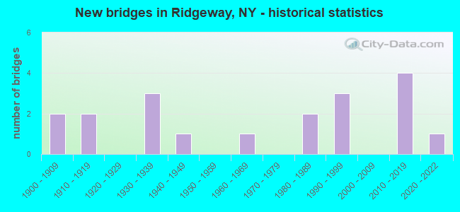
- New bridges - historical statistics
- 21900-1909
- 21910-1919
- 31930-1939
- 11940-1949
- 11960-1969
- 21980-1989
- 31990-1999
- 42010-2019
- 12020-2022
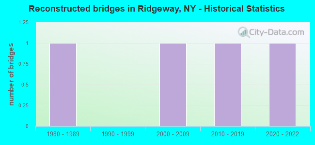
- Reconstructed bridges - Historical Statistics
- 11980-1989
- 01990-1999
- 12000-2009
- 12010-2019
- 12020-2022
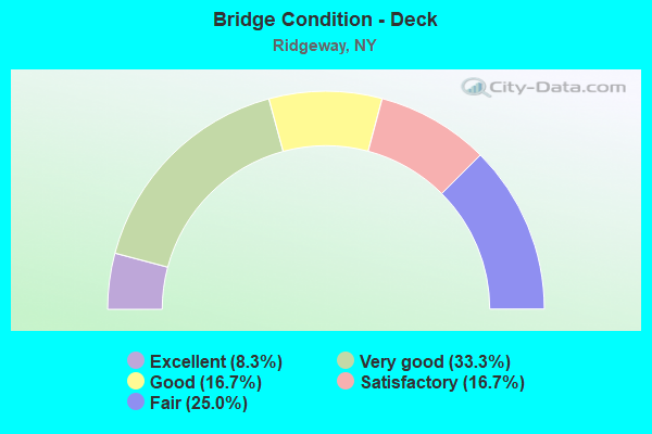
- Bridge Condition - Deck
- 8.3%Excellent
- 33.3%Very good
- 16.7%Good
- 16.7%Satisfactory
- 25.0%Fair
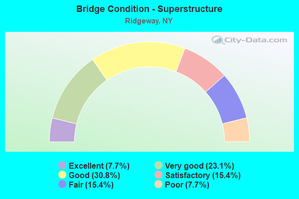
- Bridge Condition - Superstructure
- 7.7%Excellent
- 23.1%Very good
- 30.8%Good
- 15.4%Satisfactory
- 15.4%Fair
- 7.7%Poor
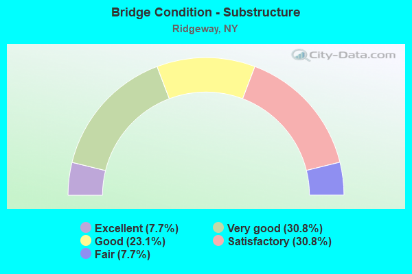
- Bridge Condition - Substructure
- 7.7%Excellent
- 30.8%Very good
- 23.1%Good
- 30.8%Satisfactory
- 7.7%Fair
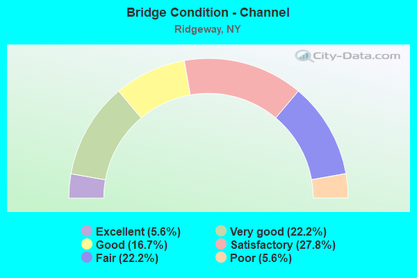
- Bridge Condition - Channel
- 5.6%Excellent
- 22.2%Very good
- 16.7%Good
- 27.8%Satisfactory
- 22.2%Fair
- 5.6%Poor

- Bridge Condition - Culverts
- 50.0%Excellent
- 16.7%Good
- 16.7%Satisfactory
- 16.7%Poor
Find on map >> Show street view
Structure Number: 102152, Location: 3.4MI E JCT RTS 31 + 63 (Lat: 43.229542, Lng: -78.323475), Route carried "on" structure: State highway 31, Year Built: 1933, Status: Open, Structure Length: 0.85m (2.79ft), Average Daily Traffic: 3,926 (year 2020), Truck Traffic: 6%, Average Future Daily Traffic: 3,963 (year 2040), Features Intersected: FISH CREEK
Minimum Vertical Clearance: 30+ m (98+ ft), Kilometerpoint: 13.371, Lanes on structure: 2, Base Highway Network: Yes, Owner: State Highway Agency, Approaching Roadway Width: 11.9m (39.0ft), Material/Design: Concrete, Design/Construction: Frame, Number Of Spans In Main Unit: 1, Length of Maximum Span: 7.3m (24.0ft), Curb-To-Curb Width: 11.9m (39.0ft), Out-to-Out Width: 12.8m (42.0ft)
Condition: Deck: Fair, Superstructure: Fair, Substructure: Good, Channel: Good, Operating Rating: 74.8 metric tons, Method Used To Determine Operating Rating: Field evaluation and documented engineering judgment, Inventory Rating: 32.7 metric tons, Method Used To Determine Inventory Rating: Field evaluation and documented engineering judgment, Structural Evaluation: Somewhat better than minimum adequacy, Deck Geometry: Somewhat better than minimum adequacy, Waterway Adequacy: Equal to present minimum criteria, Approach Roadway Alignment: Equal to present desirable criteria, Length Of Structure Improvement: 0.85m (2.79ft), Designated Inspection Frequency: Every 24 months, Inspection Date: September 2021, Bridge Improvement Cost: $336,000, Roadway Improvement Cost: $197,000, Total Project Cost: $532,000 ( Estimate for 2021)
Find on map >> Show street view
Structure Number: 102153, Location: 3.6MI E JCT RTS 31 + 63 (Lat: 43.229567, Lng: -78.317808), Route carried "on" structure: State highway 31, Year Built: 1933, Status: Open, Structure Length: 0.82m (2.69ft), Average Daily Traffic: 3,926 (year 2020), Truck Traffic: 6%, Average Future Daily Traffic: 3,963 (year 2040), Features Intersected: STILL BROOK
Minimum Vertical Clearance: 30+ m (98+ ft), Kilometerpoint: 12.904, Lanes on structure: 2, Base Highway Network: Yes, Owner: State Highway Agency, Approaching Roadway Width: 11.6m (38.1ft), Skew: 4 degrees, Material/Design: Concrete, Design/Construction: Frame, Number Of Spans In Main Unit: 1, Length of Maximum Span: 7.0m (23.0ft), Curb-To-Curb Width: 11.9m (39.0ft), Out-to-Out Width: 12.5m (41.0ft)
Condition: Deck: Satisfactory, Superstructure: Satisfactory, Substructure: Fair, Channel: Fair, Operating Rating: 53.5 metric tons, Method Used To Determine Operating Rating: Load Factor (LF), Inventory Rating: 31.8 metric tons, Method Used To Determine Inventory Rating: Load Factor (LF), Structural Evaluation: Somewhat better than minimum adequacy, Deck Geometry: Somewhat better than minimum adequacy, Waterway Adequacy: Equal to present minimum criteria, Approach Roadway Alignment: Equal to present desirable criteria, Length Of Structure Improvement: 0.82m (2.69ft), Designated Inspection Frequency: Every 24 months, Inspection Date: September 2021, Bridge Improvement Cost: $327,000, Roadway Improvement Cost: $192,000, Total Project Cost: $519,000 ( Estimate for 2021)
Find on map >> Show street view
Structure Number: 102154, Location: 4.2 MI E JCT SH 31 & SH63 (Lat: 43.228744, Lng: -78.308708), Route carried "on" structure: State highway 31, Year Built: 1984, Status: Open, Structure Length: 7.47m (24.51ft), Average Daily Traffic: 3,926 (year 2020), Truck Traffic: 6%, Average Future Daily Traffic: 3,963 (year 2040), Design Load: HS 20, Features Intersected: FALLS ROAD RR
Minimum Vertical Clearance: 30+ m (98+ ft), Kilometerpoint: 14.095, Lanes on structure: 2, Base Highway Network: Yes, Owner: State Highway Agency, Approaching Roadway Width: 12.2m (40.0ft), Skew: 5 degrees, Material/Design: Steel continuous, Design/Construction: Stringer/Multi-beam, Number Of Spans In Main Unit: 3, Length of Maximum Span: 29.2m (95.8ft), Curb-To-Curb Width: 12.2m (40.0ft), Out-to-Out Width: 13.2m (43.3ft)
Condition: Deck: Good, Superstructure: Good, Substructure: Good, Operating Rating: 81.6 metric tons, Method Used To Determine Operating Rating: Load Factor (LF), Inventory Rating: 48.1 metric tons, Method Used To Determine Inventory Rating: Load Factor (LF), Structural Evaluation: Better than present minimum criteria, Deck Geometry: Equal to present minimum criteria, Underclear: Somewhat better than minimum adequacy, Approach Roadway Alignment: Equal to present desirable criteria, Length Of Structure Improvement: 7.46m (24.48ft), Designated Inspection Frequency: Every 24 months, Inspection Date: December 2020, Bridge Improvement Cost: $2,880,000, Roadway Improvement Cost: $1,686,000, Total Project Cost: $4,566,000 ( Estimate for 2021), Deck Structure Type: Concrete Cast-file-Place, Wearing Surface/Protective System: Wearing Surface: Integral Concrete, Deck Protection: Epoxy Coated Reinforcing
Find on map >> Show street view
Structure Number: 103641, Location: 0.3MI E JCT RTS 104 + 269 (Lat: 43.255494, Lng: -78.456925), Route carried "on" structure: State highway 104, Year Built: 1914, Year Reconstructed: 2009, Status: Open, Structure Length: 1.07m (3.51ft), Average Daily Traffic: 3,543 (year 2020), Truck Traffic: 8%, Average Future Daily Traffic: 3,576 (year 2040), Design Load: HS 25 or greater, Features Intersected: JEDDO CREEK
Minimum Vertical Clearance: 30+ m (98+ ft), Kilometerpoint: 0.483, Lanes on structure: 2, Base Highway Network: Yes, Owner: State Highway Agency, Approaching Roadway Width: 12.8m (42.0ft), Material/Design: Concrete, Design/Construction: Culvert, Number Of Spans In Main Unit: 1, Length of Maximum Span: 7.7m (25.3ft), Curb-To-Curb Width: 15.5m (50.9ft), Out-to-Out Width: 16.5m (54.1ft)
Condition: Channel: Satisfactory, Culverts: Good, Operating Rating: 78.0 metric tons, Method Used To Determine Operating Rating: Field evaluation and documented engineering judgment, Inventory Rating: 40.8 metric tons, Method Used To Determine Inventory Rating: Field evaluation and documented engineering judgment, Structural Evaluation: Better than present minimum criteria, Deck Geometry: Superior to present desirable criteria, Waterway Adequacy: Superior to present desirable criteria, Approach Roadway Alignment: Equal to present desirable criteria, Length Of Structure Improvement: 0.79m (2.59ft), Designated Inspection Frequency: Every 24 months, Inspection Date: August 2021, Bridge Improvement Cost: $414,000, Roadway Improvement Cost: $243,000, Total Project Cost: $657,000 ( Estimate for 2021)
Find on map >> Show street view
Structure Number: 103642, Location: JCT RTS104+OAK ORCHARD CK (Lat: 43.274681, Lng: -78.329039), Route carried "on" structure: State highway 104, Year Built: 2021, Status: Open, Structure Length: 3.99m (13.09ft), Average Daily Traffic: 2,723 (year 2020), Truck Traffic: 12%, Average Future Daily Traffic: 2,748 (year 2040), Design Load: HL 93, Features Intersected: OAK ORCHARD CREEK
Minimum Vertical Clearance: 32.69m (107.25ft), Kilometerpoint: 11.392, Lanes on structure: 2, Owner: State Highway Agency, Approaching Roadway Width: 11.0m (36.1ft), Material/Design: Steel, Design/Construction: Stringer/Multi-beam, Number Of Spans In Main Unit: 1, Length of Maximum Span: 38.1m (125.0ft), Curb-To-Curb Width: 11.0m (36.1ft), Out-to-Out Width: 12.3m (40.4ft)
Condition: Deck: Excellent, Superstructure: Excellent, Substructure: Excellent, Channel: Good, Operating Rating: 59.9 metric tons, Method Used To Determine Operating Rating: Load and Resistance Factor Rating (LRFR) rating reported by rating factor(RF) method using HL-93 loadings, Inventory Rating: 46.3 metric tons, Method Used To Determine Inventory Rating: Load and Resistance Factor Rating (LRFR) rating reported by rating factor(RF) method using HL-93 loadings, Structural Evaluation: Superior to present desirable criteria, Deck Geometry: Somewhat better than minimum adequacy, Waterway Adequacy: Equal to present minimum criteria, Approach Roadway Alignment: Equal to present minimum criteria, Designated Inspection Frequency: Every 24 months, Inspection Date: October 2021, Deck Structure Type: Concrete Cast-file-Place, Wearing Surface/Protective System: Wearing Surface: Integral Concrete, Deck Protection: Epoxy Coated Reinforcing
Find on map >> Show street view
Structure Number: 331885, Location: 2.6 MI SW OF LYNDONVILLE (Lat: 43.302475, Lng: -78.433606), Route carried "on" structure: Alternate County highway , Year Built: 1990, Status: Open, Structure Length: 2.80m (9.19ft), Average Daily Traffic: 424 (year 2017), Truck Traffic: 9%, Average Future Daily Traffic: 594 (year 2037), Design Load: HS 20, Features Intersected: JOHNSON CREEK, Facility Carried by Structure: MURDOCK ROAD
Minimum Vertical Clearance: 30+ m (98+ ft), Kilometerpoint: 4.360, Lanes on structure: 2, Owner: County Highway Agency, Approaching Roadway Width: 5.8m (19.0ft), Material/Design: Prestressed concrete, Design/Construction: Box Beam or Girders - Multiple, Number Of Spans In Main Unit: 1, Length of Maximum Span: 27.1m (88.9ft), Curb-To-Curb Width: 7.9m (25.9ft), Out-to-Out Width: 8.6m (28.2ft)
Condition: Deck: Good, Superstructure: Good, Substructure: Very good, Channel: Fair, Operating Rating: 56.2 metric tons, Method Used To Determine Operating Rating: Load Factor (LF), Inventory Rating: 41.7 metric tons, Method Used To Determine Inventory Rating: Load Factor (LF), Structural Evaluation: Better than present minimum criteria, Deck Geometry: Somewhat better than minimum adequacy, Waterway Adequacy: Somewhat better than minimum adequacy, Approach Roadway Alignment: Equal to present desirable criteria, Length Of Structure Improvement: 2.80m (9.19ft), Designated Inspection Frequency: Every 24 months, Inspection Date: April 2021, Bridge Improvement Cost: $425,000, Roadway Improvement Cost: $249,000, Total Project Cost: $673,000 ( Estimate for 2021), Wearing Surface/Protective System: Wearing Surface: Bituminous, Membrane: Other
Find on map >> Show street view
Structure Number: 331886, Location: 2.6 MI NNE OF JEDDO (Lat: 43.292008, Lng: -78.458208), Route carried "on" structure: Alternate Other road , Year Built: 1940, Status: Open, Structure Length: 1.58m (5.18ft), Average Daily Traffic: 161 (year 2016), Truck Traffic: 7%, Average Future Daily Traffic: 225 (year 2036), Features Intersected: JEDDO CREEK, Facility Carried by Structure: MILL ROAD
Minimum Vertical Clearance: 30+ m (98+ ft), Kilometerpoint: 0.660, Lanes on structure: 2, Owner: County Highway Agency, Approaching Roadway Width: 5.5m (18.0ft), Skew: 3 degrees, Material/Design: Steel, Design/Construction: Stringer/Multi-beam, Number Of Spans In Main Unit: 2, Length of Maximum Span: 7.6m (24.9ft), Curb-To-Curb Width: 6.9m (22.6ft), Out-to-Out Width: 8.2m (26.9ft)
Condition: Deck: Fair, Superstructure: Fair, Substructure: Satisfactory, Channel: Poor, Operating Rating: 67.1 metric tons, Method Used To Determine Operating Rating: Load Factor (LF), Inventory Rating: 39.9 metric tons, Method Used To Determine Inventory Rating: Load Factor (LF), Structural Evaluation: Somewhat better than minimum adequacy, Deck Geometry: Meets minimum limits, Waterway Adequacy: Meets minimum limits, Approach Roadway Alignment: Better than present minimum criteria, Length Of Structure Improvement: 1.58m (5.18ft), Designated Inspection Frequency: Every 24 months, Inspection Date: October 2020, Bridge Improvement Cost: $710,000, Roadway Improvement Cost: $416,000, Total Project Cost: $1,125,000 ( Estimate for 2021), Deck Structure Type: Concrete Cast-file-Place, Wearing Surface/Protective System: Wearing Surface: Bituminous
Find on map >> Show street view
Structure Number: 331887, Location: 0.6 MI SOUTH OF JEDDO (Lat: 43.244900, Lng: -78.462083), Route carried "on" structure: Other road , Year Built: 1960, Status: Open, Structure Length: 0.64m (2.10ft), Average Daily Traffic: 85 (year 2020), Truck Traffic: 5%, Average Future Daily Traffic: 119 (year 2040), Design Load: H 20, Features Intersected: JEDDO CREEK, Facility Carried by Structure: COUNTY LINE ROAD
Minimum Vertical Clearance: 30+ m (98+ ft), Kilometerpoint: 0.547, Lanes on structure: 2, Owner: County Highway Agency, Approaching Roadway Width: 6.4m (21.0ft), Skew: 1 degrees, Material/Design: Steel, Design/Construction: Culvert, Number Of Spans In Main Unit: 1, Length of Maximum Span: 6.0m (19.7ft)
Condition: Channel: Fair, Culverts: Poor, Operating Rating: 72.5 metric tons, Method Used To Determine Operating Rating: Field evaluation and documented engineering judgment, Inventory Rating: 19.6 metric tons, Method Used To Determine Inventory Rating: Field evaluation and documented engineering judgment, Structural Evaluation: Meets minimum limits, Waterway Adequacy: Better than present minimum criteria, Approach Roadway Alignment: Equal to present desirable criteria, Length Of Structure Improvement: 0.64m (2.10ft), Designated Inspection Frequency: Every 24 months, Inspection Date: September 2021, Bridge Improvement Cost: $73,000, Roadway Improvement Cost: $43,000, Total Project Cost: $116,000 ( Estimate for 2021)
Find on map >> Show street view
Structure Number: 331888, Location: .4 MILE EAST OF RIDGEWAY (Lat: 43.264214, Lng: -78.386153), Route carried "on" structure: County highway , Year Built: 1991, Status: Open, Structure Length: 2.80m (9.19ft), Average Daily Traffic: 391 (year 2018), Truck Traffic: 5%, Average Future Daily Traffic: 547 (year 2038), Design Load: HS 20, Features Intersected: OAK ORCHARD CREEK, Facility Carried by Structure: HORAN ROAD
Minimum Vertical Clearance: 30+ m (98+ ft), Kilometerpoint: 3.459, Lanes on structure: 2, Owner: County Highway Agency, Approaching Roadway Width: 5.8m (19.0ft), Material/Design: Prestressed concrete, Design/Construction: Box Beam or Girders - Multiple, Number Of Spans In Main Unit: 1, Length of Maximum Span: 27.1m (88.9ft), Curb-To-Curb Width: 8.0m (26.2ft), Out-to-Out Width: 8.6m (28.2ft)
Condition: Deck: Very good, Superstructure: Very good, Substructure: Very good, Channel: Very good, Operating Rating: 88.0 metric tons, Method Used To Determine Operating Rating: Load Factor (LF), Inventory Rating: 52.6 metric tons, Method Used To Determine Inventory Rating: Load Factor (LF), Structural Evaluation: Equal to present desirable criteria, Deck Geometry: Somewhat better than minimum adequacy, Waterway Adequacy: Equal to present minimum criteria, Approach Roadway Alignment: Equal to present desirable criteria, Length Of Structure Improvement: 2.80m (9.19ft), Designated Inspection Frequency: Every 24 months, Inspection Date: April 2021, Bridge Improvement Cost: $426,000, Roadway Improvement Cost: $250,000, Total Project Cost: $676,000 ( Estimate for 2021), Wearing Surface/Protective System: Wearing Surface: Bituminous, Membrane: Other
Find on map >> Show street view
Structure Number: 331889, Location: 1.2 MI. SO. OF RIDGEWAY (Lat: 43.250094, Lng: -78.395128), Route carried "on" structure: Other road , Year Built: 1991, Status: Open, Structure Length: 2.74m (8.99ft), Average Daily Traffic: 237 (year 2017), Truck Traffic: 5%, Average Future Daily Traffic: 332 (year 2037), Design Load: HS 20, Features Intersected: OAK ORCHARD RIVER, Facility Carried by Structure: SLADE ROAD
Minimum Vertical Clearance: 30+ m (98+ ft), Kilometerpoint: 0.145, Lanes on structure: 2, Owner: County Highway Agency, Approaching Roadway Width: 7.3m (24.0ft), Skew: 2 degrees, Material/Design: Prestressed concrete, Design/Construction: Box Beam or Girders - Multiple, Number Of Spans In Main Unit: 1, Length of Maximum Span: 27.1m (88.9ft), Curb-To-Curb Width: 8.0m (26.2ft), Out-to-Out Width: 8.6m (28.2ft)
Condition: Deck: Very good, Superstructure: Good, Substructure: Very good, Channel: Satisfactory, Operating Rating: 99.8 metric tons, Method Used To Determine Operating Rating: Load Factor (LF), Inventory Rating: 59.9 metric tons, Method Used To Determine Inventory Rating: Load Factor (LF), Structural Evaluation: Better than present minimum criteria, Deck Geometry: Somewhat better than minimum adequacy, Waterway Adequacy: Equal to present desirable criteria, Approach Roadway Alignment: Equal to present desirable criteria, Length Of Structure Improvement: 2.74m (8.99ft), Designated Inspection Frequency: Every 24 months, Inspection Date: September 2020, Bridge Improvement Cost: $437,000, Roadway Improvement Cost: $256,000, Total Project Cost: $692,000 ( Estimate for 2021), Wearing Surface/Protective System: Wearing Surface: Bituminous, Membrane: Preformed Fabric
Find on map >> Show street view
Structure Number: 33189, Location: 2.6 MI S OF OAK ORCHARD (Lat: 43.237228, Lng: -78.340486), Route carried "on" structure: County highway , Year Built: 2018, Status: Open, Structure Length: 1.10m (3.61ft), Average Daily Traffic: 410 (year 2020), Truck Traffic: 5%, Average Future Daily Traffic: 574 (year 2040), Design Load: HS 25 or greater, Features Intersected: FISH CREEK, Facility Carried by Structure: CULVERT ROAD
Minimum Vertical Clearance: 30+ m (98+ ft), Kilometerpoint: 0.853, Lanes on structure: 2, Owner: County Highway Agency, Approaching Roadway Width: 6.1m (20.0ft), Material/Design: Concrete, Design/Construction: Culvert, Number Of Spans In Main Unit: 1, Length of Maximum Span: 10.4m (34.1ft), Curb-To-Curb Width: 7.4m (24.3ft), Out-to-Out Width: 8.2m (26.9ft)
Condition: Channel: Satisfactory, Culverts: Excellent, Operating Rating: 81.6 metric tons, Method Used To Determine Operating Rating: Load Factor (LF), Inventory Rating: 49.0 metric tons, Method Used To Determine Inventory Rating: Load Factor (LF), Structural Evaluation: Superior to present desirable criteria, Deck Geometry: Meets minimum limits, Waterway Adequacy: Better than present minimum criteria, Approach Roadway Alignment: Equal to present desirable criteria, Length Of Structure Improvement: 1.09m (3.58ft), Designated Inspection Frequency: Every 24 months, Inspection Date: September 2020, Bridge Improvement Cost: $234,000, Roadway Improvement Cost: $137,000, Total Project Cost: $371,000 ( Estimate for 2021), Wearing Surface/Protective System: Wearing Surface: Bituminous, Membrane: Other
Find on map >> Show street view
Structure Number: 331891, Location: 2.2 MI SW OAK ORCHARD (Lat: 43.245019, Lng: -78.352839), Route carried "on" structure: Other road , Year Built: 2018, Status: Open, Structure Length: 1.22m (4.00ft), Average Daily Traffic: 188 (year 2016), Truck Traffic: 5%, Average Future Daily Traffic: 263 (year 2036), Design Load: HS 25 or greater, Features Intersected: FISH CREEK, Facility Carried by Structure: PORTAGE ROAD
Minimum Vertical Clearance: 30+ m (98+ ft), Kilometerpoint: 2.639, Lanes on structure: 2, Owner: County Highway Agency, Approaching Roadway Width: 6.7m (22.0ft), Skew: 2 degrees, Material/Design: Concrete, Design/Construction: Culvert, Number Of Spans In Main Unit: 1, Length of Maximum Span: 11.6m (38.1ft), Curb-To-Curb Width: 8.0m (26.2ft), Out-to-Out Width: 8.8m (28.9ft)
Condition: Channel: Satisfactory, Culverts: Excellent, Operating Rating: 80.8 metric tons, Method Used To Determine Operating Rating: Field evaluation and documented engineering judgment, Inventory Rating: 40.8 metric tons, Method Used To Determine Inventory Rating: Field evaluation and documented engineering judgment, Structural Evaluation: Superior to present desirable criteria, Deck Geometry: Somewhat better than minimum adequacy, Waterway Adequacy: Better than present minimum criteria, Approach Roadway Alignment: Better than present minimum criteria, Length Of Structure Improvement: 1.21m (3.97ft), Designated Inspection Frequency: Every 24 months, Inspection Date: October 2020, Bridge Improvement Cost: $320,000, Roadway Improvement Cost: $187,000, Total Project Cost: $507,000 ( Estimate for 2021)
Find on map >> Show street view
Structure Number: 331892, Location: 1.8 MI SE RIDGEWAY (Lat: 43.258894, Lng: -78.359025), Route carried "on" structure: Other road , Year Built: 2016, Status: Open, Structure Length: 1.07m (3.51ft), Average Daily Traffic: 118 (year 2017), Truck Traffic: 5%, Average Future Daily Traffic: 165 (year 2037), Design Load: HL 93, Features Intersected: FISH CREEK, Facility Carried by Structure: EAST SCOTT ROAD
Minimum Vertical Clearance: 30+ m (98+ ft), Kilometerpoint: 2.124, Lanes on structure: 2, Owner: County Highway Agency, Approaching Roadway Width: 6.7m (22.0ft), Material/Design: Concrete, Design/Construction: Culvert, Number Of Spans In Main Unit: 1, Length of Maximum Span: 10.1m (33.1ft), Curb-To-Curb Width: 8.6m (28.2ft), Out-to-Out Width: 9.6m (31.5ft)
Condition: Channel: Excellent, Culverts: Excellent, Operating Rating: 79.7 metric tons, Method Used To Determine Operating Rating: Field evaluation and documented engineering judgment, Inventory Rating: 40.8 metric tons, Method Used To Determine Inventory Rating: Field evaluation and documented engineering judgment, Structural Evaluation: Superior to present desirable criteria, Deck Geometry: Equal to present minimum criteria, Waterway Adequacy: Meets minimum limits, Approach Roadway Alignment: Better than present minimum criteria, Length Of Structure Improvement: 1.06m (3.48ft), Designated Inspection Frequency: Every 24 months, Inspection Date: September 2020, Bridge Improvement Cost: $267,000, Roadway Improvement Cost: $156,000, Total Project Cost: $423,000 ( Estimate for 2021), Wearing Surface/Protective System: Wearing Surface: Bituminous, Membrane: Other
Find on map >> Show street view
Structure Number: 331893, Location: 1.1 MI E OF RIDGEWAY (Lat: 43.267703, Lng: -78.370511), Route carried "on" structure: County highway , Year Built: 1938, Year Reconstructed: 1993, Status: Open, Structure Length: 2.68m (8.79ft), Average Daily Traffic: 949 (year 2017), Truck Traffic: 4%, Average Future Daily Traffic: 1,329 (year 2037), Design Load: HS 20, Features Intersected: OAK ORCHARD RIVER, Facility Carried by Structure: BATES ROAD
Minimum Vertical Clearance: 30+ m (98+ ft), Kilometerpoint: 3.813, Lanes on structure: 2, Owner: County Highway Agency, Approaching Roadway Width: 7.3m (24.0ft), Material/Design: Prestressed concrete, Design/Construction: Box Beam or Girders - Multiple, Number Of Spans In Main Unit: 1, Length of Maximum Span: 26.5m (86.9ft), Curb-To-Curb Width: 7.3m (24.0ft), Out-to-Out Width: 7.5m (24.6ft)
Condition: Deck: Satisfactory, Superstructure: Satisfactory, Substructure: Satisfactory, Channel: Satisfactory, Operating Rating: 94.3 metric tons, Method Used To Determine Operating Rating: Load Factor (LF), Inventory Rating: 56.2 metric tons, Method Used To Determine Inventory Rating: Load Factor (LF), Structural Evaluation: Equal to present minimum criteria, Deck Geometry: Meets minimum limits, Waterway Adequacy: Equal to present desirable criteria, Approach Roadway Alignment: Equal to present desirable criteria, Length Of Structure Improvement: 2.68m (8.79ft), Designated Inspection Frequency: Every 24 months, Inspection Date: August 2021, Bridge Improvement Cost: $564,000, Roadway Improvement Cost: $330,000, Total Project Cost: $894,000 ( Estimate for 2021), Wearing Surface/Protective System: Wearing Surface: Bituminous, Membrane: Preformed Fabric
Find on map >> Show street view
Structure Number: 331894, Location: 1.1 MI EAST OAK ORCHARD (Lat: 43.274414, Lng: -78.310900), Route carried "on" structure: County highway , Year Built: 1988, Status: Open, Structure Length: 0.70m (2.30ft), Average Daily Traffic: 702 (year 2017), Truck Traffic: 5%, Average Future Daily Traffic: 983 (year 2037), Features Intersected: TRIB OAK ORCHARD, Facility Carried by Structure: KNOWLESVILLE ROAD
Minimum Vertical Clearance: 30+ m (98+ ft), Kilometerpoint: 3.492, Lanes on structure: 2, Owner: County Highway Agency, Approaching Roadway Width: 7.0m (23.0ft), Material/Design: Concrete continuous, Design/Construction: Culvert, Number Of Spans In Main Unit: 2, Length of Maximum Span: 3.3m (10.8ft), Curb-To-Curb Width: 10.4m (34.1ft), Out-to-Out Width: 11.0m (36.1ft)
Condition: Channel: Fair, Culverts: Satisfactory, Inventory Rating: 81.6 metric tons, Method Used To Determine Inventory Rating: Load Factor (LF), Structural Evaluation: Equal to present minimum criteria, Deck Geometry: Equal to present minimum criteria, Waterway Adequacy: Better than present minimum criteria, Approach Roadway Alignment: Equal to present minimum criteria, Length Of Structure Improvement: 0.70m (2.30ft), Designated Inspection Frequency: Every 24 months, Inspection Date: April 2020, Bridge Improvement Cost: $138,000, Roadway Improvement Cost: $81,000, Total Project Cost: $219,000 ( Estimate for 2021), Wearing Surface/Protective System: Wearing Surface: Bituminous, Membrane: Other
Find on map >> Show street view
Structure Number: 331906, Location: 1.9 MI S ASHWOOD (Lat: 43.301228, Lng: -78.310581), Route carried "on" structure: Alternate County highway , Year Built: 2010, Status: Open, Structure Length: 2.41m (7.91ft), Average Daily Traffic: 724 (year 2016), Truck Traffic: 7%, Average Future Daily Traffic: 1,014 (year 2036), Design Load: HS 25 or greater, Features Intersected: OAK ORCHARD CREEK, Facility Carried by Structure: KNOWLESVILLE ROAD
Minimum Vertical Clearance: 30+ m (98+ ft), Kilometerpoint: 2.446, Lanes on structure: 2, Owner: County Highway Agency, Approaching Roadway Width: 8.5m (27.9ft), Material/Design: Concrete, Design/Construction: Frame, Number Of Spans In Main Unit: 1, Length of Maximum Span: 23.8m (78.1ft), Curb-To-Curb Width: 7.9m (25.9ft), Out-to-Out Width: 11.0m (36.1ft)
Condition: Superstructure: Very good, Substructure: Very good, Channel: Very good, Operating Rating: 89.5 metric tons, Method Used To Determine Operating Rating: Field evaluation and documented engineering judgment, Inventory Rating: 40.8 metric tons, Method Used To Determine Inventory Rating: Field evaluation and documented engineering judgment, Structural Evaluation: Equal to present desirable criteria, Deck Geometry: Somewhat better than minimum adequacy, Waterway Adequacy: Somewhat better than minimum adequacy, Approach Roadway Alignment: Equal to present desirable criteria, Length Of Structure Improvement: 2.40m (7.87ft), Designated Inspection Frequency: Every 24 months, Inspection Date: October 2020, Bridge Improvement Cost: $555,000, Roadway Improvement Cost: $325,000, Total Project Cost: $879,000 ( Estimate for 2021)
Find on map >> Show street view
Structure Number: 444518, Location: 4.3 MI E JCT BG CNL &SH63 (Lat: 43.242661, Lng: -78.310622), Route carried "on" structure: County highway , Year Built: 1910, Year Reconstructed: 2018, Status: Posted for load-capacity, Structure Length: 4.42m (14.50ft), Average Daily Traffic: 987 (year 2017), Truck Traffic: 3%, Average Future Daily Traffic: 1,382 (year 2037), Design Load: H 20, Features Intersected: ERIE CANAL, Facility Carried by Structure: KNOWLESVILLE ROAD
Minimum Vertical Clearance: 30+ m (98+ ft), Kilometerpoint: 1.432, Lanes on structure: 2, Owner: State Highway Agency, Approaching Roadway Width: 5.5m (18.0ft), Skew: 3 degrees, Navigation Control: Yes ( Vertical Clearance: 5.1m (16.7ft), Horizontal Clearance: 26.2m (86.0ft)), Material/Design: Steel, Design/Construction: Movable - Lift, Number Of Spans In Main Unit: 1, Number Of Approach Spans: 2, Length of Maximum Span: 37.4m (122.7ft), Curb or Sidewalk Widths: Left: 1.4m (4.6ft), Right: 1.4m (4.6ft), Curb-To-Curb Width: 5.8m (19.0ft), Out-to-Out Width: 6.3m (20.7ft)
Condition: Deck: Very good, Superstructure: Good, Substructure: Satisfactory, Channel: Very good, Operating Rating: 38.1 metric tons, Method Used To Determine Operating Rating: Load Factor (LF), Inventory Rating: 22.7 metric tons, Method Used To Determine Inventory Rating: Load Factor (LF), Structural Evaluation: Equal to present minimum criteria, Deck Geometry: High priority of replacement, Waterway Adequacy: Equal to present desirable criteria, Approach Roadway Alignment: Somewhat better than minimum adequacy, Length Of Structure Improvement: 4.41m (14.47ft), Designated Inspection Frequency: Every 24 months, Critical Feature Inspection Frequency: Every 24 months, Inspection Date: August 2021, Critical Feature Inspection Date: August 2021, Bridge Improvement Cost: $4,184,000, Roadway Improvement Cost: $2,450,000, Total Project Cost: $6,634,000 ( Estimate for 2021), Deck Structure Type: Concrete Cast-file-Place, Wearing Surface/Protective System: Wearing Surface: Integral Concrete
Find on map >> Show street view
Structure Number: 444519, Location: 2 MI E JCT BG CNL & SH 63 (Lat: 43.233692, Lng: -78.355639), Route carried "on" structure: ServiceCounty highway , Year Built: 1909, Status: Posted for load, Structure Length: 5.88m (19.29ft), Average Daily Traffic: 70 (year 2016), Truck Traffic: 5%, Average Future Daily Traffic: 98 (year 2036), Features Intersected: Erie Canal Heritage Trai, Facility Carried by Structure: BEALS ROAD
Minimum Vertical Clearance: 4.19m (13.75ft), Kilometerpoint: 1.384, Lanes on structure: 1, Owner: State Highway Agency, Approaching Roadway Width: 5.5m (18.0ft), Navigation Control: Yes ( Vertical Clearance: 4.8m (15.7ft), Horizontal Clearance: 22.9m (75.1ft)), Material/Design: Steel, Design/Construction: Truss - Thru, Number Of Spans In Main Unit: 1, Number Of Approach Spans: 2, Length of Maximum Span: 45.7m (149.9ft), Curb-To-Curb Width: 4.5m (14.8ft), Out-to-Out Width: 5.0m (16.4ft)
Condition: Deck: Fair, Superstructure: Poor, Substructure: Good, Channel: Good, Operating Rating: 10.9 metric tons, Method Used To Determine Operating Rating: Field evaluation and documented engineering judgment, Inventory Rating: 10.9 metric tons, Method Used To Determine Inventory Rating: Field evaluation and documented engineering judgment, Structural Evaluation: Meets minimum limits, Deck Geometry: High priority of corrective action, Waterway Adequacy: Superior to present desirable criteria, Approach Roadway Alignment: High priority of corrective action, Bridge Posting: Required (Relationship of Operating Rating to Maximum Legal Load: > 39.9% below), Length Of Structure Improvement: 5.88m (19.29ft), Designated Inspection Frequency: Every 12 months, Critical Feature Inspection Frequency: Every 12 months, Inspection Date: July 2021, Critical Feature Inspection Date: July 2021, Bridge Improvement Cost: $2,182,000, Roadway Improvement Cost: $1,278,000, Total Project Cost: $3,460,000 ( Estimate for 2021), Wearing Surface/Protective System: Wearing Surface: Integral Concrete
Find on map >> Show street view
Structure Number: 444523, Location: 1.5 MI W JCT B CNL & SH63 (Lat: 43.222164, Lng: -78.420881), Route carried "on" structure: ServiceOther road , Year Built: 1909, Year Reconstructed: 2020, Status: Posted for load-capacity, Structure Length: 5.82m (19.09ft), Average Daily Traffic: 1,004 (year 2016), Truck Traffic: 3%, Average Future Daily Traffic: 1,406 (year 2036), Features Intersected: Canalway Trail, ERIE CAN, Facility Carried by Structure: MARSHALL ROAD
Minimum Vertical Clearance: 4.22m (13.85ft), Kilometerpoint: 0.209, Lanes on structure: 1, Owner: State Highway Agency, Approaching Roadway Width: 5.5m (18.0ft), Navigation Control: Yes ( Vertical Clearance: 5.0m (16.4ft), Horizontal Clearance: 27.4m (89.9ft)), Material/Design: Steel, Design/Construction: Truss - Thru, Number Of Spans In Main Unit: 1, Number Of Approach Spans: 2, Length of Maximum Span: 45.7m (149.9ft), Curb-To-Curb Width: 4.5m (14.8ft), Out-to-Out Width: 5.4m (17.7ft)
Condition: Deck: Very good, Superstructure: Very good, Substructure: Satisfactory, Channel: Very good, Operating Rating: 50.5 metric tons, Method Used To Determine Operating Rating: Field evaluation and documented engineering judgment, Inventory Rating: 24.5 metric tons, Method Used To Determine Inventory Rating: Field evaluation and documented engineering judgment, Structural Evaluation: Equal to present minimum criteria, Deck Geometry: High priority of replacement, Waterway Adequacy: Equal to present desirable criteria, Approach Roadway Alignment: Meets minimum limits, Length Of Structure Improvement: 5.82m (19.09ft), Designated Inspection Frequency: Every 24 months, Critical Feature Inspection Frequency: Every 24 months, Inspection Date: December 2021, Critical Feature Inspection Date: December 2021, Bridge Improvement Cost: $2,303,000, Roadway Improvement Cost: $1,349,000, Total Project Cost: $3,651,000 ( Estimate for 2021), Wearing Surface/Protective System: Wearing Surface: Integral Concrete