Bridge Statistics for Rienzi, Mississippi (MS)
Condition, Traffic, Stress, Structural Evaluation, Project Costs
- National Bridge Inventory (NBI) Statistics
- 30Number of bridges
- 427ft / 130mTotal length
- $156,000Total costs
- 113,130Total average daily traffic
- 17,573Total average daily truck traffic
- 125,554Total future (year 2021) average daily traffic
- National Bridge Inventory (NBI) Registered Bridges for Rienzi
- No street view available for this location
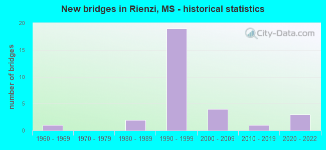
- New bridges - historical statistics
- 11960-1969
- 21980-1989
- 191990-1999
- 42000-2009
- 12010-2019
- 32020-2022


- Bridge Condition - Deck
- 10.0%Excellent
- 26.7%Very good
- 50.0%Good
- 10.0%Satisfactory
- 3.3%Fair

- Bridge Condition - Superstructure
- 3.3%Excellent
- 46.7%Very good
- 43.3%Good
- 6.7%Fair

- Bridge Condition - Substructure
- 10.0%Excellent
- 36.7%Very good
- 43.3%Good
- 10.0%Fair

- Bridge Condition - Channel
- 6.7%Excellent
- 33.3%Very good
- 40.0%Good
- 16.7%Satisfactory
- 3.3%Fair
Find on map >> Show street view
Structure Number: 21000450022632B, Location: 1.1 MI N PRENTISS CL (Lat: 34.772361, Lng: -88.559689), Route carried "on" structure: US 45, Year Built: 1991, Status: Open, Structure Length: 3.71m (12.17ft), Average Daily Traffic: 7,500 (year 2020), Truck Traffic: 15%, Average Future Daily Traffic: 8,500 (year 2040), Design Load: HS 20, Features Intersected: HINKLE CREEK RELIEF
Minimum Vertical Clearance: 30+ m (98+ ft), Kilometerpoint: 1.796, Lanes on structure: 2, Base Highway Network: Yes (Inventory Route: 4, Subroute: 1), Owner: State Highway Agency, Approaching Roadway Width: 12.8m (42.0ft), Skew: 10 degrees, Material/Design: Prestressed concrete continuous, Design/Construction: Stringer/Multi-beam, Number Of Spans In Main Unit: 3, Length of Maximum Span: 12.2m (40.0ft), Curb-To-Curb Width: 12.2m (40.0ft), Out-to-Out Width: 13.0m (42.7ft)
Condition: Deck: Good, Superstructure: Good, Substructure: Good, Channel: Good, Operating Rating: 68.6 metric tons, Method Used To Determine Operating Rating: Load Factor (LF), Inventory Rating: 38.5 metric tons, Method Used To Determine Inventory Rating: Load Factor (LF), Structural Evaluation: Better than present minimum criteria, Deck Geometry: Better than present minimum criteria, Waterway Adequacy: Equal to present minimum criteria, Approach Roadway Alignment: Equal to present desirable criteria, Designated Inspection Frequency: Every 24 months, Underwater Inspection Frequency: Every 60 months, Inspection Date: July 2021, Underwater Inspection Date: July 2019, Deck Structure Type: Concrete Cast-file-Place
Find on map >> Show street view
Structure Number: 21000450022633A, Location: 1.2 MI N PRENTISS CL (Lat: 34.774575, Lng: -88.560072), Route carried "on" structure: US 45, Year Built: 1991, Status: Open, Structure Length: 4.93m (16.17ft), Average Daily Traffic: 7,500 (year 2020), Truck Traffic: 15%, Average Future Daily Traffic: 8,500 (year 2040), Design Load: HS 20, Features Intersected: HINKLE CREEK
Minimum Vertical Clearance: 30+ m (98+ ft), Kilometerpoint: 25.513, Lanes on structure: 2, Base Highway Network: Yes (Inventory Route: 4, Subroute: 1), Owner: State Highway Agency, Approaching Roadway Width: 12.8m (42.0ft), Skew: 10 degrees, Material/Design: Prestressed concrete continuous, Design/Construction: Stringer/Multi-beam, Number Of Spans In Main Unit: 2, Number Of Approach Spans: 1, Length of Maximum Span: 18.3m (60.0ft), Curb-To-Curb Width: 12.2m (40.0ft), Out-to-Out Width: 13.0m (42.7ft)
Condition: Deck: Good, Superstructure: Good, Substructure: Good, Channel: Satisfactory, Operating Rating: 66.3 metric tons, Method Used To Determine Operating Rating: Load Factor (LF), Inventory Rating: 36.3 metric tons, Method Used To Determine Inventory Rating: Load Factor (LF), Structural Evaluation: Better than present minimum criteria, Deck Geometry: Better than present minimum criteria, Waterway Adequacy: Equal to present minimum criteria, Approach Roadway Alignment: Equal to present desirable criteria, Designated Inspection Frequency: Every 24 months, Inspection Date: July 2021, Deck Structure Type: Concrete Cast-file-Place
Find on map >> Show street view
Structure Number: 21000450022633B, Location: 1.2 MI N PRENTISS CL (Lat: 34.773964, Lng: -88.559667), Route carried "on" structure: US 45, Year Built: 1991, Status: Open, Structure Length: 4.93m (16.17ft), Average Daily Traffic: 7,500 (year 2020), Truck Traffic: 15%, Average Future Daily Traffic: 8,500 (year 2040), Design Load: HS 20, Features Intersected: HINKLE CREEK
Minimum Vertical Clearance: 30+ m (98+ ft), Kilometerpoint: 1.975, Lanes on structure: 2, Base Highway Network: Yes (Inventory Route: 4, Subroute: 1), Owner: State Highway Agency, Approaching Roadway Width: 12.8m (42.0ft), Skew: 10 degrees, Material/Design: Prestressed concrete continuous, Design/Construction: Stringer/Multi-beam, Number Of Spans In Main Unit: 2, Number Of Approach Spans: 1, Length of Maximum Span: 18.3m (60.0ft), Curb-To-Curb Width: 12.2m (40.0ft), Out-to-Out Width: 13.0m (42.7ft)
Condition: Deck: Good, Superstructure: Good, Substructure: Good, Channel: Satisfactory, Operating Rating: 66.3 metric tons, Method Used To Determine Operating Rating: Load Factor (LF), Inventory Rating: 36.3 metric tons, Method Used To Determine Inventory Rating: Load Factor (LF), Structural Evaluation: Better than present minimum criteria, Deck Geometry: Better than present minimum criteria, Waterway Adequacy: Equal to present minimum criteria, Approach Roadway Alignment: Equal to present desirable criteria, Designated Inspection Frequency: Every 24 months, Inspection Date: July 2021, Deck Structure Type: Concrete Cast-file-Place
Find on map >> Show street view
Structure Number: 21000450022648A, Location: 2.7 MI N PRENTISS CL (Lat: 34.793267, Lng: -88.559842), Route carried "on" structure: US 45, Year Built: 1991, Status: Open, Structure Length: 2.79m (9.15ft), Average Daily Traffic: 7,500 (year 2020), Truck Traffic: 15%, Average Future Daily Traffic: 8,500 (year 2040), Design Load: HS 20, Features Intersected: BYNUM CREEK
Minimum Vertical Clearance: 30+ m (98+ ft), Kilometerpoint: 23.440, Lanes on structure: 2, Base Highway Network: Yes (Inventory Route: 4, Subroute: 1), Owner: State Highway Agency, Approaching Roadway Width: 12.8m (42.0ft), Skew: 10 degrees, Material/Design: Prestressed concrete continuous, Design/Construction: Stringer/Multi-beam, Number Of Spans In Main Unit: 3, Length of Maximum Span: 9.1m (29.9ft), Curb-To-Curb Width: 12.2m (40.0ft), Out-to-Out Width: 13.0m (42.7ft)
Condition: Deck: Good, Superstructure: Very good, Substructure: Good, Channel: Good, Operating Rating: 67.3 metric tons, Method Used To Determine Operating Rating: Load Factor (LF), Inventory Rating: 40.3 metric tons, Method Used To Determine Inventory Rating: Load Factor (LF), Structural Evaluation: Better than present minimum criteria, Deck Geometry: Better than present minimum criteria, Waterway Adequacy: Equal to present minimum criteria, Approach Roadway Alignment: Equal to present desirable criteria, Designated Inspection Frequency: Every 24 months, Inspection Date: July 2021, Deck Structure Type: Concrete Cast-file-Place
Find on map >> Show street view
Structure Number: 21000450022648B, Location: 2.7 MI N PRENTISS CL (Lat: 34.793011, Lng: -88.559428), Route carried "on" structure: US 45, Year Built: 1991, Status: Open, Structure Length: 2.79m (9.15ft), Average Daily Traffic: 7,500 (year 2020), Truck Traffic: 15%, Average Future Daily Traffic: 8,500 (year 2040), Design Load: HS 20, Features Intersected: BYNUM CREEK
Minimum Vertical Clearance: 30+ m (98+ ft), Kilometerpoint: 4.088, Lanes on structure: 2, Base Highway Network: Yes (Inventory Route: 4, Subroute: 1), Owner: State Highway Agency, Approaching Roadway Width: 12.8m (42.0ft), Skew: 10 degrees, Material/Design: Prestressed concrete continuous, Design/Construction: Stringer/Multi-beam, Number Of Spans In Main Unit: 3, Length of Maximum Span: 9.1m (29.9ft), Curb-To-Curb Width: 12.2m (40.0ft), Out-to-Out Width: 13.0m (42.7ft)
Condition: Deck: Good, Superstructure: Good, Substructure: Good, Channel: Good, Operating Rating: 67.3 metric tons, Method Used To Determine Operating Rating: Load Factor (LF), Inventory Rating: 40.3 metric tons, Method Used To Determine Inventory Rating: Load Factor (LF), Structural Evaluation: Better than present minimum criteria, Deck Geometry: Better than present minimum criteria, Waterway Adequacy: Equal to present minimum criteria, Approach Roadway Alignment: Equal to present desirable criteria, Designated Inspection Frequency: Every 24 months, Inspection Date: July 2021, Deck Structure Type: Concrete Cast-file-Place
Find on map >> Show street view
Structure Number: 21000450022662A, Location: 4.1 MI N PRENTISS CL (Lat: 34.816000, Lng: -88.559633), Route carried "on" structure: US 45, Year Built: 1991, Status: Open, Structure Length: 3.10m (10.17ft), Average Daily Traffic: 8,000 (year 2020), Truck Traffic: 16%, Average Future Daily Traffic: 8,500 (year 2040), Design Load: HS 20, Features Intersected: PARMICHA CREEK RELIEF
Minimum Vertical Clearance: 30+ m (98+ ft), Kilometerpoint: 20.918, Lanes on structure: 2, Base Highway Network: Yes (Inventory Route: 4, Subroute: 1), Owner: State Highway Agency, Approaching Roadway Width: 12.8m (42.0ft), Skew: 13 degrees, Material/Design: Prestressed concrete continuous, Design/Construction: Stringer/Multi-beam, Number Of Spans In Main Unit: 3, Length of Maximum Span: 12.2m (40.0ft), Curb-To-Curb Width: 12.2m (40.0ft), Out-to-Out Width: 13.0m (42.7ft)
Condition: Deck: Good, Superstructure: Good, Substructure: Good, Channel: Very good, Operating Rating: 68.6 metric tons, Method Used To Determine Operating Rating: Load Factor (LF), Inventory Rating: 38.5 metric tons, Method Used To Determine Inventory Rating: Load Factor (LF), Structural Evaluation: Better than present minimum criteria, Deck Geometry: Better than present minimum criteria, Waterway Adequacy: Equal to present minimum criteria, Approach Roadway Alignment: Equal to present desirable criteria, Designated Inspection Frequency: Every 24 months, Inspection Date: July 2021, Deck Structure Type: Concrete Cast-file-Place
Find on map >> Show street view
Structure Number: 21000450022662B, Location: 4.1 MI N PRENTISS CL (Lat: 34.815900, Lng: -88.559214), Route carried "on" structure: US 45, Year Built: 1991, Status: Open, Structure Length: 3.10m (10.17ft), Average Daily Traffic: 8,000 (year 2020), Truck Traffic: 16%, Average Future Daily Traffic: 8,500 (year 2040), Design Load: HS 20, Features Intersected: PARMICHA CREEK RELIEF
Minimum Vertical Clearance: 30+ m (98+ ft), Kilometerpoint: 6.627, Lanes on structure: 2, Base Highway Network: Yes (Inventory Route: 4, Subroute: 1), Owner: State Highway Agency, Approaching Roadway Width: 12.8m (42.0ft), Skew: 13 degrees, Material/Design: Prestressed concrete continuous, Design/Construction: Stringer/Multi-beam, Number Of Spans In Main Unit: 3, Length of Maximum Span: 12.2m (40.0ft), Curb-To-Curb Width: 12.2m (40.0ft), Out-to-Out Width: 13.0m (42.7ft)
Condition: Deck: Good, Superstructure: Good, Substructure: Very good, Channel: Very good, Operating Rating: 68.6 metric tons, Method Used To Determine Operating Rating: Load Factor (LF), Inventory Rating: 38.5 metric tons, Method Used To Determine Inventory Rating: Load Factor (LF), Structural Evaluation: Better than present minimum criteria, Deck Geometry: Better than present minimum criteria, Waterway Adequacy: Equal to present minimum criteria, Approach Roadway Alignment: Equal to present desirable criteria, Designated Inspection Frequency: Every 24 months, Inspection Date: July 2021, Deck Structure Type: Concrete Cast-file-Place
Find on map >> Show street view
Structure Number: 21000450022664A, Location: 4.3 MI N PRENTISS CL (Lat: 34.818047, Lng: -88.559608), Route carried "on" structure: US 45, Year Built: 1991, Status: Open, Structure Length: 5.13m (16.83ft), Average Daily Traffic: 8,000 (year 2020), Truck Traffic: 16%, Average Future Daily Traffic: 8,500 (year 2040), Design Load: HS 20, Features Intersected: PARMICHA CREEK
Minimum Vertical Clearance: 30+ m (98+ ft), Kilometerpoint: 20.691, Lanes on structure: 2, Base Highway Network: Yes (Inventory Route: 4, Subroute: 1), Owner: State Highway Agency, Approaching Roadway Width: 12.8m (42.0ft), Skew: 14 degrees, Material/Design: Prestressed concrete continuous, Design/Construction: Stringer/Multi-beam, Number Of Spans In Main Unit: 3, Length of Maximum Span: 16.8m (55.1ft), Curb-To-Curb Width: 12.2m (40.0ft), Out-to-Out Width: 13.0m (42.7ft)
Condition: Deck: Good, Superstructure: Good, Substructure: Good, Channel: Good, Operating Rating: 73.5 metric tons, Method Used To Determine Operating Rating: Load Factor (LF), Inventory Rating: 39.7 metric tons, Method Used To Determine Inventory Rating: Load Factor (LF), Structural Evaluation: Better than present minimum criteria, Deck Geometry: Better than present minimum criteria, Waterway Adequacy: Equal to present minimum criteria, Approach Roadway Alignment: Equal to present desirable criteria, Designated Inspection Frequency: Every 24 months, Inspection Date: July 2021, Deck Structure Type: Concrete Cast-file-Place
Find on map >> Show street view
Structure Number: 21000450022664B, Location: 4.3 MI N PRENTISS CL (Lat: 34.817878, Lng: -88.559194), Route carried "on" structure: US 45, Year Built: 1991, Status: Open, Structure Length: 5.13m (16.83ft), Average Daily Traffic: 8,000 (year 2020), Truck Traffic: 16%, Average Future Daily Traffic: 8,500 (year 2040), Design Load: HS 20, Features Intersected: PARMICHA CREEK
Minimum Vertical Clearance: 30+ m (98+ ft), Kilometerpoint: 6.848, Lanes on structure: 2, Base Highway Network: Yes (Inventory Route: 4, Subroute: 1), Owner: State Highway Agency, Approaching Roadway Width: 12.8m (42.0ft), Skew: 14 degrees, Material/Design: Prestressed concrete continuous, Design/Construction: Stringer/Multi-beam, Number Of Spans In Main Unit: 3, Length of Maximum Span: 16.8m (55.1ft), Curb-To-Curb Width: 12.2m (40.0ft), Out-to-Out Width: 13.0m (42.7ft)
Condition: Deck: Good, Superstructure: Good, Substructure: Good, Channel: Good, Operating Rating: 73.5 metric tons, Method Used To Determine Operating Rating: Load Factor (LF), Inventory Rating: 39.7 metric tons, Method Used To Determine Inventory Rating: Load Factor (LF), Structural Evaluation: Better than present minimum criteria, Deck Geometry: Better than present minimum criteria, Waterway Adequacy: Equal to present minimum criteria, Approach Roadway Alignment: Equal to present desirable criteria, Designated Inspection Frequency: Every 24 months, Inspection Date: July 2021, Deck Structure Type: Concrete Cast-file-Place
Find on map >> Show street view
Structure Number: 21000450022665A, Location: 4.4 MI N PRENTISS CL (Lat: 34.819100, Lng: -88.559597), Route carried "on" structure: US 45, Year Built: 1991, Status: Open, Structure Length: 2.80m (9.19ft), Average Daily Traffic: 8,000 (year 2020), Truck Traffic: 16%, Average Future Daily Traffic: 8,500 (year 2040), Design Load: HS 20, Features Intersected: PARMICHA RELIEF
Minimum Vertical Clearance: 30+ m (98+ ft), Kilometerpoint: 20.575, Lanes on structure: 2, Base Highway Network: Yes (Inventory Route: 4, Subroute: 1), Owner: State Highway Agency, Approaching Roadway Width: 12.8m (42.0ft), Skew: 13 degrees, Material/Design: Prestressed concrete continuous, Design/Construction: Stringer/Multi-beam, Number Of Spans In Main Unit: 3, Length of Maximum Span: 9.1m (29.9ft), Curb-To-Curb Width: 12.2m (40.0ft), Out-to-Out Width: 13.0m (42.7ft)
Condition: Deck: Satisfactory, Superstructure: Very good, Substructure: Good, Channel: Very good, Operating Rating: 70.6 metric tons, Method Used To Determine Operating Rating: Load Factor (LF), Inventory Rating: 42.3 metric tons, Method Used To Determine Inventory Rating: Load Factor (LF), Structural Evaluation: Better than present minimum criteria, Deck Geometry: Better than present minimum criteria, Waterway Adequacy: Equal to present minimum criteria, Approach Roadway Alignment: Equal to present desirable criteria, Designated Inspection Frequency: Every 24 months, Inspection Date: July 2021, Deck Structure Type: Concrete Cast-file-Place
Find on map >> Show street view
Structure Number: 21000450022665B, Location: 4.4 MI N PRENTISS CL (Lat: 34.819033, Lng: -88.559183), Route carried "on" structure: US 45, Year Built: 1991, Status: Open, Structure Length: 2.80m (9.19ft), Average Daily Traffic: 8,000 (year 2020), Truck Traffic: 16%, Average Future Daily Traffic: 8,500 (year 2040), Design Load: HS 20, Features Intersected: PARMICHA RELIEF
Minimum Vertical Clearance: 30+ m (98+ ft), Kilometerpoint: 6.975, Lanes on structure: 2, Base Highway Network: Yes (Inventory Route: 4, Subroute: 1), Owner: State Highway Agency, Approaching Roadway Width: 12.8m (42.0ft), Skew: 13 degrees, Material/Design: Prestressed concrete continuous, Design/Construction: Stringer/Multi-beam, Number Of Spans In Main Unit: 3, Length of Maximum Span: 9.1m (29.9ft), Curb-To-Curb Width: 12.2m (40.0ft), Out-to-Out Width: 13.0m (42.7ft)
Condition: Deck: Good, Superstructure: Good, Substructure: Very good, Channel: Very good, Operating Rating: 70.6 metric tons, Method Used To Determine Operating Rating: Load Factor (LF), Inventory Rating: 42.3 metric tons, Method Used To Determine Inventory Rating: Load Factor (LF), Structural Evaluation: Better than present minimum criteria, Deck Geometry: Better than present minimum criteria, Waterway Adequacy: Equal to present minimum criteria, Approach Roadway Alignment: Equal to present desirable criteria, Designated Inspection Frequency: Every 24 months, Inspection Date: July 2021, Deck Structure Type: Concrete Cast-file-Place
Find on map >> Show street view
Structure Number: 21000450592611A, Location: 1.5 MI S ALCORN CL (Lat: 34.734686, Lng: -88.560642), Route carried "on" structure: US 45, Year Built: 1995, Status: Open, Structure Length: 9.82m (32.22ft), Average Daily Traffic: 7,000 (year 2020), Truck Traffic: 17%, Average Future Daily Traffic: 8,000 (year 2040), Design Load: HS 20, Features Intersected: POLLYS CREEK
Minimum Vertical Clearance: 30+ m (98+ ft), Kilometerpoint: 2.387, Lanes on structure: 2, Base Highway Network: Yes (Inventory Route: 4, Subroute: 1), Owner: State Highway Agency, Approaching Roadway Width: 12.8m (42.0ft), Skew: 14 degrees, Material/Design: Prestressed concrete, Design/Construction: Stringer/Multi-beam, Number Of Spans In Main Unit: 1, Number Of Approach Spans: 6, Length of Maximum Span: 24.4m (80.1ft), Curb-To-Curb Width: 12.2m (40.0ft), Out-to-Out Width: 13.0m (42.7ft)
Condition: Deck: Very good, Superstructure: Very good, Substructure: Good, Channel: Satisfactory, Operating Rating: 61.8 metric tons, Method Used To Determine Operating Rating: Load Factor (LF), Inventory Rating: 23.0 metric tons, Method Used To Determine Inventory Rating: Load Factor (LF), Structural Evaluation: Somewhat better than minimum adequacy, Deck Geometry: Better than present minimum criteria, Waterway Adequacy: Equal to present desirable criteria, Approach Roadway Alignment: Equal to present desirable criteria, Designated Inspection Frequency: Every 24 months, Inspection Date: March 2020, Deck Structure Type: Concrete Cast-file-Place
Find on map >> Show street view
Structure Number: 21000450592621A, Location: 0.5 MI S ALCORN CL (Lat: 34.749131, Lng: -88.560194), Route carried "on" structure: US 45, Year Built: 1995, Status: Open, Structure Length: 5.86m (19.23ft), Average Daily Traffic: 7,000 (year 2020), Truck Traffic: 17%, Average Future Daily Traffic: 8,000 (year 2040), Design Load: HS 20, Features Intersected: BOONE CREEK
Minimum Vertical Clearance: 30+ m (98+ ft), Kilometerpoint: 0.782, Lanes on structure: 2, Base Highway Network: Yes (Inventory Route: 4, Subroute: 1), Owner: State Highway Agency, Approaching Roadway Width: 12.8m (42.0ft), Skew: 10 degrees, Material/Design: Prestressed concrete, Design/Construction: Stringer/Multi-beam, Number Of Spans In Main Unit: 2, Number Of Approach Spans: 1, Length of Maximum Span: 21.3m (69.9ft), Curb-To-Curb Width: 12.2m (40.0ft), Out-to-Out Width: 13.0m (42.7ft)
Condition: Deck: Good, Superstructure: Very good, Substructure: Very good, Channel: Good, Operating Rating: 59.9 metric tons, Method Used To Determine Operating Rating: Load Factor (LF), Inventory Rating: 27.9 metric tons, Method Used To Determine Inventory Rating: Load Factor (LF), Structural Evaluation: Better than present minimum criteria, Deck Geometry: Better than present minimum criteria, Waterway Adequacy: Equal to present desirable criteria, Approach Roadway Alignment: Equal to present desirable criteria, Designated Inspection Frequency: Every 24 months, Inspection Date: March 2020, Deck Structure Type: Concrete Cast-file-Place
Find on map >> Show street view
Structure Number: 21000450592621B, Location: 0.5 MI S ALCORN CL (Lat: 34.748214, Lng: -88.559786), Route carried "on" structure: US 45, Year Built: 1995, Status: Open, Structure Length: 7.70m (25.26ft), Average Daily Traffic: 7,000 (year 2020), Truck Traffic: 18%, Average Future Daily Traffic: 8,000 (year 2040), Design Load: HS 20, Features Intersected: BOONE CREEK
Minimum Vertical Clearance: 30+ m (98+ ft), Kilometerpoint: 28.963, Lanes on structure: 2, Base Highway Network: Yes (Inventory Route: 4, Subroute: 1), Owner: State Highway Agency, Approaching Roadway Width: 12.8m (42.0ft), Skew: 13 degrees, Material/Design: Prestressed concrete, Design/Construction: Stringer/Multi-beam, Number Of Spans In Main Unit: 2, Number Of Approach Spans: 1, Length of Maximum Span: 33.5m (109.9ft), Curb-To-Curb Width: 12.2m (40.0ft), Out-to-Out Width: 13.0m (42.7ft)
Condition: Deck: Very good, Superstructure: Very good, Substructure: Very good, Channel: Very good, Operating Rating: 64.3 metric tons, Method Used To Determine Operating Rating: Load Factor (LF), Inventory Rating: 25.4 metric tons, Method Used To Determine Inventory Rating: Load Factor (LF), Structural Evaluation: Equal to present minimum criteria, Deck Geometry: Better than present minimum criteria, Waterway Adequacy: Equal to present desirable criteria, Approach Roadway Alignment: Equal to present desirable criteria, Designated Inspection Frequency: Every 24 months, Inspection Date: March 2020, Deck Structure Type: Concrete Cast-file-Place
Find on map >> Show street view
Structure Number: 31003560020056, Location: 2.4 MI E US 45 (Lat: 34.770267, Lng: -88.522011), Route carried "on" structure: State highway 356, Year Built: 1985, Status: Open, Structure Length: 4.73m (15.52ft), Average Daily Traffic: 760 (year 2020), Truck Traffic: 11%, Average Future Daily Traffic: 760 (year 2040), Design Load: HS 20, Features Intersected: TUSCUMBIA RIVER RELIEF
Minimum Vertical Clearance: 30+ m (98+ ft), Kilometerpoint: 8.951, Lanes on structure: 2, Owner: State Highway Agency, Approaching Roadway Width: 11.0m (36.1ft), Material/Design: Concrete, Design/Construction: Channel Beam, Number Of Spans In Main Unit: 5, Length of Maximum Span: 9.4m (30.8ft), Curb-To-Curb Width: 8.5m (27.9ft), Out-to-Out Width: 9.3m (30.5ft)
Condition: Deck: Fair, Superstructure: Fair, Substructure: Fair, Channel: Good, Operating Rating: 80.3 metric tons, Method Used To Determine Operating Rating: Load Factor (LF), Inventory Rating: 48.1 metric tons, Method Used To Determine Inventory Rating: Load Factor (LF), Structural Evaluation: Somewhat better than minimum adequacy, Deck Geometry: Somewhat better than minimum adequacy, Waterway Adequacy: Equal to present desirable criteria, Approach Roadway Alignment: Equal to present desirable criteria, Designated Inspection Frequency: Every 24 months, Inspection Date: July 2021, Deck Structure Type: Concrete Precast Panels, Wearing Surface/Protective System: Wearing Surface: Bituminous
Find on map >> Show street view
Structure Number: 31003560020057, Location: 2.5 MI E US 45 (Lat: 34.770122, Lng: -88.519686), Route carried "on" structure: State highway 356, Year Built: 1985, Status: Open, Structure Length: 3.11m (10.20ft), Average Daily Traffic: 760 (year 2020), Truck Traffic: 11%, Average Future Daily Traffic: 760 (year 2040), Design Load: HS 20, Features Intersected: TUSCUMBIA RIVER
Minimum Vertical Clearance: 30+ m (98+ ft), Kilometerpoint: 9.165, Lanes on structure: 2, Owner: State Highway Agency, Approaching Roadway Width: 11.0m (36.1ft), Material/Design: Prestressed concrete, Design/Construction: Slab, Number Of Spans In Main Unit: 1, Number Of Approach Spans: 2, Length of Maximum Span: 12.2m (40.0ft), Curb-To-Curb Width: 9.1m (29.9ft), Out-to-Out Width: 10.0m (32.8ft)
Condition: Deck: Good, Superstructure: Good, Substructure: Fair, Channel: Satisfactory, Operating Rating: 41.8 metric tons, Method Used To Determine Operating Rating: Load Factor (LF), Inventory Rating: 25.0 metric tons, Method Used To Determine Inventory Rating: Load Factor (LF), Structural Evaluation: Somewhat better than minimum adequacy, Deck Geometry: Equal to present minimum criteria, Waterway Adequacy: Equal to present desirable criteria, Approach Roadway Alignment: Equal to present desirable criteria, Designated Inspection Frequency: Every 24 months, Inspection Date: July 2021, Deck Structure Type: Concrete Precast Panels, Wearing Surface/Protective System: Wearing Surface: Bituminous
Find on map >> Show street view
Structure Number: 31003560020059, Location: 2.7 MI E US 45 (Lat: 34.770283, Lng: -88.517531), Route carried "on" structure: State highway 356, Year Built: 2000, Status: Open, Structure Length: 3.65m (11.98ft), Average Daily Traffic: 760 (year 2020), Truck Traffic: 11%, Average Future Daily Traffic: 760 (year 2040), Design Load: HS 20, Features Intersected: MOORES CREEK TRIB
Minimum Vertical Clearance: 30+ m (98+ ft), Kilometerpoint: 9.365, Lanes on structure: 2, Owner: State Highway Agency, Approaching Roadway Width: 12.0m (39.4ft), Material/Design: Prestressed concrete, Design/Construction: Stringer/Multi-beam, Number Of Spans In Main Unit: 3, Length of Maximum Span: 12.0m (39.4ft), Curb-To-Curb Width: 12.0m (39.4ft), Out-to-Out Width: 12.9m (42.3ft)
Condition: Deck: Very good, Superstructure: Good, Substructure: Very good, Channel: Very good, Operating Rating: 61.0 metric tons, Method Used To Determine Operating Rating: Load Factor (LF), Inventory Rating: 36.6 metric tons, Method Used To Determine Inventory Rating: Load Factor (LF), Structural Evaluation: Better than present minimum criteria, Deck Geometry: Better than present minimum criteria, Waterway Adequacy: Equal to present desirable criteria, Approach Roadway Alignment: Equal to present desirable criteria, Designated Inspection Frequency: Every 24 months, Inspection Date: July 2021, Deck Structure Type: Concrete Cast-file-Place
Find on map >> Show street view
Structure Number: 3100356002006, Location: 2.8 MI E US 45 (Lat: 34.770797, Lng: -88.516208), Route carried "on" structure: State highway 356, Year Built: 2000, Status: Open, Structure Length: 3.65m (11.98ft), Average Daily Traffic: 760 (year 2020), Truck Traffic: 11%, Average Future Daily Traffic: 760 (year 2040), Design Load: HS 20, Features Intersected: MOORES CREEK TRIB
Minimum Vertical Clearance: 30+ m (98+ ft), Kilometerpoint: 9.498, Lanes on structure: 2, Owner: State Highway Agency, Approaching Roadway Width: 12.0m (39.4ft), Skew: 1 degrees, Material/Design: Prestressed concrete continuous, Design/Construction: Stringer/Multi-beam, Number Of Spans In Main Unit: 3, Length of Maximum Span: 12.0m (39.4ft), Curb-To-Curb Width: 12.0m (39.4ft), Out-to-Out Width: 12.9m (42.3ft)
Condition: Deck: Very good, Superstructure: Good, Substructure: Very good, Channel: Good, Operating Rating: 62.7 metric tons, Method Used To Determine Operating Rating: Load Factor (LF), Inventory Rating: 37.6 metric tons, Method Used To Determine Inventory Rating: Load Factor (LF), Structural Evaluation: Better than present minimum criteria, Deck Geometry: Better than present minimum criteria, Waterway Adequacy: Equal to present desirable criteria, Approach Roadway Alignment: Equal to present desirable criteria, Designated Inspection Frequency: Every 24 months, Inspection Date: July 2021, Deck Structure Type: Concrete Cast-file-Place
Find on map >> Show street view
Structure Number: 31003560020062, Location: 3.0 MI E US 45 (Lat: 34.772889, Lng: -88.512364), Route carried "on" structure: State highway 356, Year Built: 2000, Status: Open, Structure Length: 3.65m (11.98ft), Average Daily Traffic: 760 (year 2020), Truck Traffic: 11%, Average Future Daily Traffic: 760 (year 2040), Design Load: HS 20, Features Intersected: MOORES CREEK
Minimum Vertical Clearance: 30+ m (98+ ft), Kilometerpoint: 9.920, Lanes on structure: 2, Owner: State Highway Agency, Approaching Roadway Width: 12.0m (39.4ft), Skew: 2 degrees, Material/Design: Prestressed concrete continuous, Design/Construction: Stringer/Multi-beam, Number Of Spans In Main Unit: 3, Length of Maximum Span: 12.0m (39.4ft), Curb-To-Curb Width: 12.0m (39.4ft), Out-to-Out Width: 12.9m (42.3ft)
Condition: Deck: Very good, Superstructure: Very good, Substructure: Very good, Channel: Very good, Operating Rating: 62.7 metric tons, Method Used To Determine Operating Rating: Load Factor (LF), Inventory Rating: 37.6 metric tons, Method Used To Determine Inventory Rating: Load Factor (LF), Structural Evaluation: Equal to present desirable criteria, Deck Geometry: Better than present minimum criteria, Waterway Adequacy: Equal to present desirable criteria, Approach Roadway Alignment: Equal to present desirable criteria, Designated Inspection Frequency: Every 24 months, Inspection Date: July 2021, Deck Structure Type: Concrete Cast-file-Place
Find on map >> Show street view
Structure Number: SA0200000000124, Location: SEC 35 T 3S R 7E B (Lat: 34.778889, Lng: -88.539444), Route carried "on" structure: County highway 979, Year Built: 1996, Status: Open, Structure Length: 4.27m (14.01ft), Average Daily Traffic: 740 (year 2021), Truck Traffic: 8%, Average Future Daily Traffic: 1,110 (year 2040), Design Load: HS 20, Features Intersected: HINKLE CREEK, Facility Carried by Structure: CR 409
Minimum Vertical Clearance: 30+ m (98+ ft), Kilometerpoint: 2.253, Lanes on structure: 2, Owner: County Highway Agency, Approaching Roadway Width: 6.7m (22.0ft), Skew: 4 degrees, Material/Design: Prestressed concrete, Design/Construction: Stringer/Multi-beam, Number Of Spans In Main Unit: 3, Length of Maximum Span: 18.3m (60.0ft), Curb or Sidewalk Widths: Left: 0.5m (1.6ft), Right: 0.5m (1.6ft), Curb-To-Curb Width: 8.5m (27.9ft), Out-to-Out Width: 9.5m (31.2ft)
Condition: Deck: Good, Superstructure: Very good, Substructure: Good, Channel: Satisfactory, Operating Rating: 66.7 metric tons, Method Used To Determine Operating Rating: Load Factor (LF), Inventory Rating: 36.0 metric tons, Method Used To Determine Inventory Rating: Load Factor (LF), Structural Evaluation: Better than present minimum criteria, Deck Geometry: Somewhat better than minimum adequacy, Waterway Adequacy: Equal to present desirable criteria, Approach Roadway Alignment: Equal to present desirable criteria, Designated Inspection Frequency: Every 24 months, Inspection Date: August 2021, Deck Structure Type: Concrete Cast-file-Place, Wearing Surface/Protective System: Wearing Surface: Monolithic Concrete
Find on map >> Show street view
Structure Number: SA0200000000125, Location: SEC 35 T 3S R 7E B (Lat: 34.780267, Lng: -88.539458), Route carried "on" structure: County highway 979, Year Built: 1996, Status: Open, Structure Length: 4.27m (14.01ft), Average Daily Traffic: 740 (year 2021), Truck Traffic: 8%, Average Future Daily Traffic: 1,110 (year 2040), Design Load: HS 20, Features Intersected: BYNUM CR, Facility Carried by Structure: CR 409
Minimum Vertical Clearance: 30+ m (98+ ft), Kilometerpoint: 2.414, Lanes on structure: 2, Owner: County Highway Agency, Approaching Roadway Width: 6.7m (22.0ft), Skew: 4 degrees, Material/Design: Prestressed concrete, Design/Construction: Stringer/Multi-beam, Number Of Spans In Main Unit: 3, Length of Maximum Span: 18.3m (60.0ft), Curb or Sidewalk Widths: Left: 0.5m (1.6ft), Right: 0.5m (1.6ft), Curb-To-Curb Width: 8.5m (27.9ft), Out-to-Out Width: 9.5m (31.2ft)
Condition: Deck: Good, Superstructure: Very good, Substructure: Good, Channel: Good, Operating Rating: 66.7 metric tons, Method Used To Determine Operating Rating: Load Factor (LF), Inventory Rating: 36.0 metric tons, Method Used To Determine Inventory Rating: Load Factor (LF), Structural Evaluation: Better than present minimum criteria, Deck Geometry: Somewhat better than minimum adequacy, Waterway Adequacy: Equal to present desirable criteria, Approach Roadway Alignment: Equal to present desirable criteria, Designated Inspection Frequency: Every 24 months, Inspection Date: August 2021, Deck Structure Type: Concrete Cast-file-Place, Wearing Surface/Protective System: Wearing Surface: Monolithic Concrete
Find on map >> Show street view
Structure Number: SA0200000000129, Location: SEC 19 T 3S R 8E B (Lat: 34.812778, Lng: -88.494722), Route carried "on" structure: County highway 136, Year Built: 1994, Status: Open, Structure Length: 4.88m (16.01ft), Average Daily Traffic: 450 (year 2021), Truck Traffic: 8%, Average Future Daily Traffic: 675 (year 2040), Design Load: HS 20, Features Intersected: HURRICANE CREEK, Facility Carried by Structure: CR 430
Minimum Vertical Clearance: 30+ m (98+ ft), Kilometerpoint: 7.402, Lanes on structure: 2, Owner: County Highway Agency, Approaching Roadway Width: 8.1m (26.6ft), Skew: 3 degrees, Material/Design: Prestressed concrete, Design/Construction: Stringer/Multi-beam, Number Of Spans In Main Unit: 3, Length of Maximum Span: 24.4m (80.1ft), Curb or Sidewalk Widths: Left: 0.5m (1.6ft), Right: 0.5m (1.6ft), Curb-To-Curb Width: 8.5m (27.9ft), Out-to-Out Width: 9.5m (31.2ft)
Condition: Deck: Satisfactory, Superstructure: Good, Substructure: Good, Channel: Good, Operating Rating: 66.0 metric tons, Method Used To Determine Operating Rating: Load Factor (LF), Inventory Rating: 36.9 metric tons, Method Used To Determine Inventory Rating: Load Factor (LF), Structural Evaluation: Better than present minimum criteria, Deck Geometry: Somewhat better than minimum adequacy, Waterway Adequacy: Equal to present desirable criteria, Approach Roadway Alignment: Equal to present desirable criteria, Designated Inspection Frequency: Every 24 months, Inspection Date: September 2021, Deck Structure Type: Concrete Cast-file-Place, Wearing Surface/Protective System: Wearing Surface: Monolithic Concrete
Find on map >> Show street view
Structure Number: SA5900000000009, Location: SEC 10 T 4S R 7E (Lat: 34.740389, Lng: -88.542556), Route carried "on" structure: County highway 209, Year Built: 1999, Status: Open, Structure Length: 5.64m (18.50ft), Average Daily Traffic: 80 (year 2015), Truck Traffic: 10%, Average Future Daily Traffic: 135 (year 2035), Design Load: HS 20, Features Intersected: POLLYS CREEK, Facility Carried by Structure: CR 1021
Minimum Vertical Clearance: 30+ m (98+ ft), Kilometerpoint: 9.495, Lanes on structure: 2, Owner: County Highway Agency, Approaching Roadway Width: 7.3m (24.0ft), Material/Design: Concrete, Design/Construction: Channel Beam, Number Of Spans In Main Unit: 6, Length of Maximum Span: 9.4m (30.8ft), Curb or Sidewalk Widths: Left: 0.5m (1.6ft), Right: 0.5m (1.6ft), Curb-To-Curb Width: 8.5m (27.9ft), Out-to-Out Width: 9.5m (31.2ft)
Condition: Deck: Very good, Superstructure: Very good, Substructure: Very good, Channel: Good, Operating Rating: 63.1 metric tons, Method Used To Determine Operating Rating: Load Factor (LF), Inventory Rating: 37.9 metric tons, Method Used To Determine Inventory Rating: Load Factor (LF), Structural Evaluation: Equal to present desirable criteria, Deck Geometry: Better than present minimum criteria, Waterway Adequacy: Equal to present desirable criteria, Approach Roadway Alignment: Equal to present desirable criteria, Designated Inspection Frequency: Every 24 months, Inspection Date: Febuary 2021, Deck Structure Type: Concrete Precast Panels, Wearing Surface/Protective System: Wearing Surface: Monolithic Concrete
Find on map >> Show street view
Structure Number: SA590000000001, Location: SEC 10 T 4S R 7E (Lat: 34.742694, Lng: -88.543083), Route carried "on" structure: County highway 209, Year Built: 1996, Status: Open, Structure Length: 3.78m (12.40ft), Average Daily Traffic: 90 (year 2015), Truck Traffic: 10%, Average Future Daily Traffic: 135 (year 2035), Design Load: HS 20, Features Intersected: BOONE CREEK, Facility Carried by Structure: CR 1021
Minimum Vertical Clearance: 30+ m (98+ ft), Kilometerpoint: 9.977, Lanes on structure: 2, Owner: County Highway Agency, Approaching Roadway Width: 6.7m (22.0ft), Material/Design: Concrete, Design/Construction: Channel Beam, Number Of Spans In Main Unit: 4, Length of Maximum Span: 9.4m (30.8ft), Curb or Sidewalk Widths: Left: 0.2m (0.7ft), Right: 0.2m (0.7ft), Curb-To-Curb Width: 8.1m (26.6ft), Out-to-Out Width: 8.5m (27.9ft)
Condition: Deck: Very good, Superstructure: Very good, Substructure: Very good, Channel: Good, Operating Rating: 75.8 metric tons, Method Used To Determine Operating Rating: Load Factor (LF), Inventory Rating: 45.4 metric tons, Method Used To Determine Inventory Rating: Load Factor (LF), Structural Evaluation: Equal to present desirable criteria, Deck Geometry: Equal to present minimum criteria, Waterway Adequacy: Equal to present desirable criteria, Approach Roadway Alignment: Equal to present desirable criteria, Designated Inspection Frequency: Every 24 months, Inspection Date: Febuary 2021, Deck Structure Type: Concrete Precast Panels, Wearing Surface/Protective System: Wearing Surface: Monolithic Concrete
Find on map >> Show street view
Structure Number: SA5900000000015, Location: SEC 13 T 4S R 7E (Lat: 34.734139, Lng: -88.518444), Route carried "on" structure: County highway 99, Year Built: 1967, Status: Posted for load, Structure Length: 1.60m (5.25ft), Average Daily Traffic: 140 (year 2015), Truck Traffic: 8%, Average Future Daily Traffic: 210 (year 2035), Design Load: H 10, Features Intersected: TUSCUMBIA RIVER, Facility Carried by Structure: CR 1150
Minimum Vertical Clearance: 30+ m (98+ ft), Kilometerpoint: 0.965, Lanes on structure: 1, Owner: County Highway Agency, Approaching Roadway Width: 4.6m (15.1ft), Material/Design: Wood or Timber, Design/Construction: Stringer/Multi-beam, Number Of Spans In Main Unit: 3, Length of Maximum Span: 7.3m (24.0ft), Curb-To-Curb Width: 5.2m (17.1ft), Out-to-Out Width: 5.2m (17.1ft)
Condition: Deck: Satisfactory, Superstructure: Fair, Substructure: Fair, Channel: Fair, Operating Rating: 20.1 metric tons, Method Used To Determine Operating Rating: Allowable Stress (AS) rating reported by rating factor (RF) method using MS18 loading, Inventory Rating: 12.0 metric tons, Method Used To Determine Inventory Rating: Allowable Stress (AS) rating reported by rating factor (RF) method using MS18 loading, Structural Evaluation: Meets minimum limits, Deck Geometry: High priority of replacement, Waterway Adequacy: Equal to present desirable criteria, Approach Roadway Alignment: Equal to present desirable criteria, Bridge Posting: Required (Relationship of Operating Rating to Maximum Legal Load: > 39.9% below), Length Of Structure Improvement: 2.10m (6.89ft), Designated Inspection Frequency: Every 12 months, Inspection Date: January 2021, Bridge Improvement Cost: $125,000, Roadway Improvement Cost: $15,000, Total Project Cost: $156,000 ( Estimate for 2016), Deck Structure Type: Wood or Timber, Wearing Surface/Protective System: Wearing Surface: Gravel
Find on map >> Show street view
Structure Number: SA5900000000143, Location: SEC 12 T 4S R 7E (Lat: 34.756000, Lng: -88.516556), Route carried "on" structure: County highway 97, Year Built: 2006, Status: Open, Structure Length: 4.88m (16.01ft), Average Daily Traffic: 45 (year 2016), Average Future Daily Traffic: 68 (year 2021), Design Load: HS 20, Features Intersected: TUSCUMBIA RIVER, Facility Carried by Structure: COUNTY ROAD 1151
Minimum Vertical Clearance: 30+ m (98+ ft), Kilometerpoint: 0.800, Lanes on structure: 2, Owner: County Highway Agency, Approaching Roadway Width: 6.7m (22.0ft), Material/Design: Prestressed concrete, Design/Construction: Stringer/Multi-beam, Number Of Spans In Main Unit: 3, Length of Maximum Span: 24.4m (80.1ft), Curb or Sidewalk Widths: Left: 0.5m (1.6ft), Right: 0.5m (1.6ft), Curb-To-Curb Width: 8.5m (27.9ft), Out-to-Out Width: 9.5m (31.2ft)
Condition: Deck: Good, Superstructure: Very good, Substructure: Very good, Channel: Very good, Operating Rating: 58.2 metric tons, Method Used To Determine Operating Rating: Load Factor (LF), Inventory Rating: 28.1 metric tons, Method Used To Determine Inventory Rating: Load Factor (LF), Structural Evaluation: Better than present minimum criteria, Deck Geometry: Better than present minimum criteria, Waterway Adequacy: Equal to present desirable criteria, Approach Roadway Alignment: Equal to present desirable criteria, Designated Inspection Frequency: Every 24 months, Inspection Date: March 2020, Deck Structure Type: Concrete Cast-file-Place, Wearing Surface/Protective System: Wearing Surface: Monolithic Concrete
Find on map >> Show street view
Structure Number: SA5900000000152, Location: SEC 12 T 4S R 7E (Lat: 34.756000, Lng: -88.519028), Route carried "on" structure: County highway 97, Year Built: 2011, Status: Open, Structure Length: 4.88m (16.01ft), Average Daily Traffic: 50 (year 2016), Average Future Daily Traffic: 68 (year 2036), Design Load: HL 93, Features Intersected: RELIEF TUSCUMBIA RIVER, Facility Carried by Structure: COUNTY ROAD 1151
Minimum Vertical Clearance: 30+ m (98+ ft), Kilometerpoint: 0.560, Lanes on structure: 2, Owner: County Highway Agency, Approaching Roadway Width: 6.7m (22.0ft), Material/Design: Concrete, Design/Construction: Channel Beam, Number Of Spans In Main Unit: 4, Length of Maximum Span: 12.2m (40.0ft), Curb or Sidewalk Widths: Left: 0.5m (1.6ft), Right: 0.5m (1.6ft), Curb-To-Curb Width: 8.5m (27.9ft), Out-to-Out Width: 9.5m (31.2ft)
Condition: Deck: Very good, Superstructure: Very good, Substructure: Very good, Channel: Very good, Operating Rating: 50.5 metric tons, Method Used To Determine Operating Rating: Load and Resistance Factor Rating (LRFR) rating reported by rating factor(RF) method using HL-93 loadings, Inventory Rating: 38.9 metric tons, Method Used To Determine Inventory Rating: Load and Resistance Factor Rating (LRFR) rating reported by rating factor(RF) method using HL-93 loadings, Structural Evaluation: Equal to present desirable criteria, Deck Geometry: Better than present minimum criteria, Waterway Adequacy: Equal to present desirable criteria, Approach Roadway Alignment: Equal to present desirable criteria, Designated Inspection Frequency: Every 24 months, Inspection Date: April 2020, Deck Structure Type: Concrete Precast Panels, Wearing Surface/Protective System: Wearing Surface: Monolithic Concrete
Find on map >> Show street view
Structure Number: SA590000000A011, Location: SEC 11 T 4S R 7E B (Lat: 34.742328, Lng: -88.525008), Route carried "on" structure: County highway 314, Year Built: 2020, Status: Open, Structure Length: 3.66m (12.01ft), Average Daily Traffic: 120 (year 2015), Truck Traffic: 8%, Average Future Daily Traffic: 180 (year 2035), Design Load: HL 93, Features Intersected: POLLYS CREEK, Facility Carried by Structure: CR 1121
Minimum Vertical Clearance: 30+ m (98+ ft), Kilometerpoint: 23.335, Lanes on structure: 2, Owner: County Highway Agency, Approaching Roadway Width: 5.5m (18.0ft), Material/Design: Concrete, Design/Construction: Channel Beam, Number Of Spans In Main Unit: 3, Length of Maximum Span: 12.2m (40.0ft), Curb-To-Curb Width: 9.1m (29.9ft), Out-to-Out Width: 9.9m (32.5ft)
Condition: Deck: Excellent, Superstructure: Very good, Substructure: Excellent, Channel: Very good, Operating Rating: 49.2 metric tons, Method Used To Determine Operating Rating: Load and Resistance Factor Rating (LRFR) rating reported by rating factor(RF) method using HL-93 loadings, Inventory Rating: 38.9 metric tons, Method Used To Determine Inventory Rating: Load and Resistance Factor Rating (LRFR) rating reported by rating factor(RF) method using HL-93 loadings, Structural Evaluation: Equal to present desirable criteria, Deck Geometry: Equal to present minimum criteria, Waterway Adequacy: Equal to present desirable criteria, Approach Roadway Alignment: Superior to present desirable criteria, Designated Inspection Frequency: Every 24 months, Inspection Date: November 2020, Deck Structure Type: Concrete Precast Panels, Wearing Surface/Protective System: Wearing Surface: Monolithic Concrete
Find on map >> Show street view
Structure Number: SA590000000A012, Location: SEC 11 T 4S R 7E B (Lat: 34.745453, Lng: -88.525161), Route carried "on" structure: County highway 341, Year Built: 2020, Status: Open, Structure Length: 3.66m (12.01ft), Average Daily Traffic: 275 (year 2013), Truck Traffic: 8%, Average Future Daily Traffic: 413 (year 2035), Design Load: HL 93, Features Intersected: UNNAMED CREEK, Facility Carried by Structure: COUNTY ROAD 1121
Minimum Vertical Clearance: 30+ m (98+ ft), Kilometerpoint: 23.496, Lanes on structure: 2, Owner: County Highway Agency, Approaching Roadway Width: 6.7m (22.0ft), Skew: 3 degrees, Material/Design: Concrete, Design/Construction: Channel Beam, Number Of Spans In Main Unit: 3, Length of Maximum Span: 12.2m (40.0ft), Curb-To-Curb Width: 8.5m (27.9ft), Out-to-Out Width: 9.3m (30.5ft)
Condition: Deck: Excellent, Superstructure: Excellent, Substructure: Excellent, Channel: Excellent, Operating Rating: 50.5 metric tons, Method Used To Determine Operating Rating: Load and Resistance Factor Rating (LRFR) rating reported by rating factor(RF) method using HL-93 loadings, Inventory Rating: 38.9 metric tons, Method Used To Determine Inventory Rating: Load and Resistance Factor Rating (LRFR) rating reported by rating factor(RF) method using HL-93 loadings, Structural Evaluation: Superior to present desirable criteria, Deck Geometry: Equal to present minimum criteria, Waterway Adequacy: Equal to present desirable criteria, Approach Roadway Alignment: Superior to present desirable criteria, Designated Inspection Frequency: Every 24 months, Inspection Date: November 2020, Deck Structure Type: Concrete Precast Panels, Wearing Surface/Protective System: Wearing Surface: Monolithic Concrete
Find on map >> Show street view
Structure Number: SA590000000A016, Location: SEC 14 T 4S R 7E B (Lat: 34.741311, Lng: -88.524964), Route carried "on" structure: County highway 341, Year Built: 2020, Status: Open, Structure Length: 4.88m (16.01ft), Average Daily Traffic: 100 (year 2015), Average Future Daily Traffic: 150 (year 2035), Design Load: HL 93, Features Intersected: POLLYS CREEK, Facility Carried by Structure: CR 1121
Minimum Vertical Clearance: 30+ m (98+ ft), Kilometerpoint: 23.013, Lanes on structure: 2, Owner: County Highway Agency, Approaching Roadway Width: 5.2m (17.1ft), Material/Design: Concrete, Design/Construction: Channel Beam, Number Of Spans In Main Unit: 4, Length of Maximum Span: 12.2m (40.0ft), Curb-To-Curb Width: 9.1m (29.9ft), Out-to-Out Width: 9.9m (32.5ft)
Condition: Deck: Excellent, Superstructure: Very good, Substructure: Excellent, Channel: Excellent, Operating Rating: 49.2 metric tons, Method Used To Determine Operating Rating: Load and Resistance Factor Rating (LRFR) rating reported by rating factor(RF) method using HL-93 loadings, Inventory Rating: 38.9 metric tons, Method Used To Determine Inventory Rating: Load and Resistance Factor Rating (LRFR) rating reported by rating factor(RF) method using HL-93 loadings, Structural Evaluation: Equal to present desirable criteria, Deck Geometry: Better than present minimum criteria, Waterway Adequacy: Equal to present desirable criteria, Approach Roadway Alignment: Superior to present desirable criteria, Designated Inspection Frequency: Every 24 months, Inspection Date: November 2020, Deck Structure Type: Concrete Precast Panels, Wearing Surface/Protective System: Wearing Surface: Monolithic Concrete