Bridge Statistics for Riga, New York (NY)
Condition, Traffic, Stress, Structural Evaluation, Project Costs
- National Bridge Inventory (NBI) Statistics
- 16Number of bridges
- 161ft / 49.0mTotal length
- $35,826,000Total costs
- 110,791Total average daily traffic
- 2,799Total average daily truck traffic
- National Bridge Inventory (NBI) Registered Bridges for Riga
- No street view available for this location
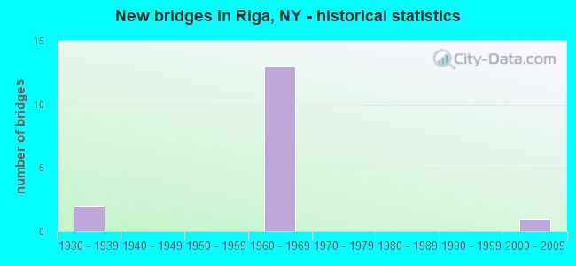
- New bridges - historical statistics
- 21930-1939
- 131960-1969
- 12000-2009

- Reconstructed bridges - Historical Statistics
- 11970-1979
- 01980-1989
- 31990-1999
- 12000-2009


- Bridge Condition - Deck
- 9.1%Very good
- 36.4%Good
- 27.3%Satisfactory
- 27.3%Fair

- Bridge Condition - Superstructure
- 9.1%Excellent
- 9.1%Good
- 36.4%Satisfactory
- 36.4%Fair
- 9.1%Poor

- Bridge Condition - Substructure
- 9.1%Excellent
- 9.1%Very good
- 36.4%Good
- 9.1%Satisfactory
- 9.1%Fair
- 27.3%Poor

- Bridge Condition - Channel
- 80.0%Good
- 20.0%Fair
Find on map >> Show street view
Structure Number: 1023, Location: 1 MILE SW OF CHURCHVILLE (Lat: 43.091900, Lng: -77.921039), Route carried "on" structure: State highway 33, Year Built: 1939, Year Reconstructed: 1975, Status: Posted for load-capacity, Structure Length: 8.93m (29.30ft), Average Daily Traffic: 2,937 (year 2017), Truck Traffic: 8%, Average Future Daily Traffic: 3,063 (year 2040), Design Load: HS 20, Features Intersected: CSX TRANS/ AMTRAK
Minimum Vertical Clearance: 4.36m (14.30ft), Kilometerpoint: 0.821, Lanes on structure: 2, Base Highway Network: Yes, Owner: State Highway Agency, Approaching Roadway Width: 13.4m (44.0ft), Material/Design: Steel, Design/Construction: Truss - Thru, Number Of Spans In Main Unit: 2, Length of Maximum Span: 43.9m (144.0ft), Curb-To-Curb Width: 14.4m (47.2ft), Out-to-Out Width: 15.6m (51.2ft)
Condition: Deck: Fair, Superstructure: Poor, Substructure: Fair, Operating Rating: 33.6 metric tons, Method Used To Determine Operating Rating: Load Factor (LF), Inventory Rating: 20.0 metric tons, Method Used To Determine Inventory Rating: Load Factor (LF), Structural Evaluation: Meets minimum limits, Deck Geometry: Meets minimum limits, Underclear: Meets minimum limits, Approach Roadway Alignment: Equal to present desirable criteria, Length Of Structure Improvement: 8.93m (29.30ft), Designated Inspection Frequency: Every 24 months, Critical Feature Inspection Frequency: Every 12 months, Inspection Date: December 2021, Critical Feature Inspection Date: December 2021, Bridge Improvement Cost: $10,385,000, Roadway Improvement Cost: $6,081,000, Total Project Cost: $16,466,000 ( Estimate for 2021), Deck Structure Type: Concrete Cast-file-Place, Wearing Surface/Protective System: Wearing Surface: Integral Concrete
Find on map >> Show street view
Structure Number: 102307, Location: JCT RTS I490+33A RIGA (Lat: 43.074178, Lng: -77.933675), Route carried "on" structure: Alternate State highway 33A, Year Built: 1964, Year Reconstructed: 1998, Status: Open, Structure Length: 4.48m (14.70ft), Average Daily Traffic: 2,089 (year 2017), Truck Traffic: 10%, Average Future Daily Traffic: 2,179 (year 2040), Design Load: HS 20+Mod, Features Intersected: RTE I490
Minimum Vertical Clearance: 30+ m (98+ ft), Kilometerpoint: 0.032, Lanes on structure: 4, Lanes under structure: 3, Base Highway Network: Yes, Owner: State Highway Agency, Approaching Roadway Width: 18.9m (62.0ft), Skew: 21 degrees, Material/Design: Steel, Design/Construction: Stringer/Multi-beam, Number Of Spans In Main Unit: 3, Length of Maximum Span: 18.8m (61.7ft), Curb-To-Curb Width: 17.7m (58.1ft), Out-to-Out Width: 18.7m (61.4ft)
Condition: Deck: Fair, Superstructure: Satisfactory, Substructure: Satisfactory, Operating Rating: 55.4 metric tons, Method Used To Determine Operating Rating: Load and Resistance Factor Rating (LRFR) rating reported by rating factor(RF) method using HL-93 loadings, Inventory Rating: 42.8 metric tons, Method Used To Determine Inventory Rating: Load and Resistance Factor Rating (LRFR) rating reported by rating factor(RF) method using HL-93 loadings, Structural Evaluation: Equal to present minimum criteria, Deck Geometry: Somewhat better than minimum adequacy, Underclear: High priority of corrective action, Approach Roadway Alignment: Equal to present desirable criteria, Length Of Structure Improvement: 4.48m (14.70ft), Designated Inspection Frequency: Every 24 months, Inspection Date: June 2020, Bridge Improvement Cost: $1,995,000, Roadway Improvement Cost: $1,168,000, Total Project Cost: $3,163,000 ( Estimate for 2021), Deck Structure Type: Concrete Cast-file-Place, Wearing Surface/Protective System: Wearing Surface: Monolithic Concrete
Find on map >> Show street view
Structure Number: 104856, Location: 1.2MINE JCT RTSI490WB+33A (Lat: 43.085936, Lng: -77.918758), Route carried "on" structure: Other road , Year Built: 1963, Year Reconstructed: 1997, Status: Open, Structure Length: 4.45m (14.60ft), Average Daily Traffic: 129 (year 2016), Truck Traffic: 5%, Average Future Daily Traffic: 181 (year 2036), Design Load: HS 20+Mod, Features Intersected: RTE I490, Facility Carried by Structure: SHERIDAN ROAD
Minimum Vertical Clearance: 30+ m (98+ ft), Kilometerpoint: 0.338, Lanes on structure: 2, Lanes under structure: 2, Owner: State Highway Agency, Approaching Roadway Width: 9.1m (29.9ft), Skew: 1 degrees, Material/Design: Steel, Design/Construction: Stringer/Multi-beam, Number Of Spans In Main Unit: 3, Length of Maximum Span: 17.6m (57.7ft), Curb-To-Curb Width: 9.1m (29.9ft), Out-to-Out Width: 10.1m (33.1ft)
Condition: Deck: Good, Superstructure: Satisfactory, Substructure: Good, Operating Rating: 73.5 metric tons, Method Used To Determine Operating Rating: Load Factor (LF), Inventory Rating: 41.7 metric tons, Method Used To Determine Inventory Rating: Load Factor (LF), Structural Evaluation: Equal to present minimum criteria, Deck Geometry: Equal to present minimum criteria, Underclear: High priority of corrective action, Approach Roadway Alignment: Equal to present minimum criteria, Length Of Structure Improvement: 4.45m (14.60ft), Designated Inspection Frequency: Every 24 months, Inspection Date: August 2020, Bridge Improvement Cost: $1,080,000, Roadway Improvement Cost: $633,000, Total Project Cost: $1,713,000 ( Estimate for 2021), Deck Structure Type: Concrete Cast-file-Place, Wearing Surface/Protective System: Wearing Surface: Integral Concrete
Find on map >> Show street view
Structure Number: 1048571, Location: 0.2MI E JCT RTS I490EB+36 (Lat: 43.094800, Lng: -77.880522), Route carried "on" structure: Interstate 490, Year Built: 1964, Status: Open, Structure Length: 4.36m (14.30ft), Average Daily Traffic: 9,910 (year 2009), Truck Traffic: 13%, Design Load: HS 20+Mod, Features Intersected: BLACK CREEK
Minimum Vertical Clearance: 30+ m (98+ ft), Kilometerpoint: 8.367, Lanes on structure: 2, Base Highway Network: Yes, Owner: State Highway Agency, Approaching Roadway Width: 17.1m (56.1ft), Material/Design: Steel, Design/Construction: Stringer/Multi-beam, Number Of Spans In Main Unit: 2, Length of Maximum Span: 21.0m (68.9ft), Curb-To-Curb Width: 16.8m (55.1ft), Out-to-Out Width: 17.8m (58.4ft)
Condition: Deck: Good, Superstructure: Fair, Substructure: Very good, Channel: Good, Operating Rating: 56.4 metric tons, Method Used To Determine Operating Rating: Load and Resistance Factor Rating (LRFR) rating reported by rating factor(RF) method using HL-93 loadings, Inventory Rating: 43.4 metric tons, Method Used To Determine Inventory Rating: Load and Resistance Factor Rating (LRFR) rating reported by rating factor(RF) method using HL-93 loadings, Structural Evaluation: Somewhat better than minimum adequacy, Deck Geometry: Superior to present desirable criteria, Waterway Adequacy: Superior to present desirable criteria, Approach Roadway Alignment: Equal to present desirable criteria, Length Of Structure Improvement: 4.35m (14.27ft), Designated Inspection Frequency: Every 24 months, Inspection Date: August 2021, Bridge Improvement Cost: $1,939,000, Roadway Improvement Cost: $1,135,000, Total Project Cost: $3,074,000 ( Estimate for 2021), Deck Structure Type: Concrete Cast-file-Place, Wearing Surface/Protective System: Wearing Surface: Monolithic Concrete
Find on map >> Show street view
Structure Number: 1048572, Location: 0.2MI E JCT RTS I490WB+36 (Lat: 43.094231, Lng: -77.880211), Route carried "on" structure: Interstate 490, Year Built: 1964, Status: Open, Structure Length: 4.36m (14.30ft), Average Daily Traffic: 8,348 (year 2019), Truck Traffic: 11%, Average Future Daily Traffic: 10,239 (year 2040), Design Load: HS 20+Mod, Features Intersected: BLACK CREEK
Minimum Vertical Clearance: 30+ m (98+ ft), Kilometerpoint: 8.367, Lanes on structure: 2, Base Highway Network: Yes, Owner: State Highway Agency, Approaching Roadway Width: 17.1m (56.1ft), Material/Design: Steel, Design/Construction: Stringer/Multi-beam, Number Of Spans In Main Unit: 2, Length of Maximum Span: 21.0m (68.9ft), Curb-To-Curb Width: 16.8m (55.1ft), Out-to-Out Width: 17.8m (58.4ft)
Condition: Deck: Good, Superstructure: Fair, Substructure: Good, Channel: Good, Operating Rating: 75.3 metric tons, Method Used To Determine Operating Rating: Load Factor (LF), Inventory Rating: 44.5 metric tons, Method Used To Determine Inventory Rating: Load Factor (LF), Structural Evaluation: Somewhat better than minimum adequacy, Deck Geometry: Superior to present desirable criteria, Waterway Adequacy: Equal to present minimum criteria, Approach Roadway Alignment: Equal to present desirable criteria, Length Of Structure Improvement: 4.35m (14.27ft), Designated Inspection Frequency: Every 24 months, Inspection Date: August 2021, Bridge Improvement Cost: $1,848,000, Roadway Improvement Cost: $1,082,000, Total Project Cost: $2,930,000 ( Estimate for 2021), Deck Structure Type: Concrete Cast-file-Place, Wearing Surface/Protective System: Wearing Surface: Monolithic Concrete
Find on map >> Show street view
Structure Number: 104858, Location: 2.1 MI W JCT I490EB&SH259 (Lat: 43.094581, Lng: -77.840853), Route carried "on" structure: County highway , Year Built: 1963, Status: Open, Structure Length: 5.39m (17.68ft), Average Daily Traffic: 1,223 (year 2016), Truck Traffic: 2%, Average Future Daily Traffic: 1,712 (year 2036), Design Load: HS 20+Mod, Features Intersected: RTE I490, Facility Carried by Structure: ATTRIDGE ROAD
Minimum Vertical Clearance: 30+ m (98+ ft), Kilometerpoint: 3.315, Lanes on structure: 2, Lanes under structure: 2, Owner: State Highway Agency, Approaching Roadway Width: 7.3m (24.0ft), Skew: 3 degrees, Material/Design: Steel, Design/Construction: Stringer/Multi-beam, Number Of Spans In Main Unit: 3, Length of Maximum Span: 21.6m (70.9ft), Curb or Sidewalk Widths: Left: 0.4m (1.3ft), Right: 0.4m (1.3ft), Curb-To-Curb Width: 8.5m (27.9ft), Out-to-Out Width: 10.2m (33.5ft)
Condition: Deck: Satisfactory, Superstructure: Fair, Substructure: Poor, Operating Rating: 63.5 metric tons, Method Used To Determine Operating Rating: Load Factor (LF), Inventory Rating: 38.1 metric tons, Method Used To Determine Inventory Rating: Load Factor (LF), Structural Evaluation: Meets minimum limits, Deck Geometry: Somewhat better than minimum adequacy, Underclear: High priority of corrective action, Approach Roadway Alignment: Equal to present desirable criteria, Length Of Structure Improvement: 5.39m (17.68ft), Designated Inspection Frequency: Every 24 months, Inspection Date: June 2021, Bridge Improvement Cost: $1,350,000, Roadway Improvement Cost: $791,000, Total Project Cost: $2,141,000 ( Estimate for 2021), Deck Structure Type: Concrete Cast-file-Place, Wearing Surface/Protective System: Wearing Surface: Monolithic Concrete, Deck Protection: Other Coated Reinforcing
Find on map >> Show street view
Structure Number: 106397, Location: 1.8MI W JCT RTS I490WB+36 (Lat: 43.086622, Lng: -77.918742), Route carried "on" structure: State highway , Year Built: 1963, Year Reconstructed: 1997, Status: Open, Structure Length: 4.39m (14.40ft), Average Daily Traffic: 129 (year 2016), Truck Traffic: 5%, Average Future Daily Traffic: 181 (year 2036), Design Load: HS 20+Mod, Features Intersected: RTE I490, Facility Carried by Structure: SHERIDAN ROAD
Minimum Vertical Clearance: 30+ m (98+ ft), Kilometerpoint: 0.418, Lanes on structure: 2, Lanes under structure: 2, Owner: State Highway Agency, Approaching Roadway Width: 7.3m (24.0ft), Skew: 1 degrees, Material/Design: Steel, Design/Construction: Stringer/Multi-beam, Number Of Spans In Main Unit: 3, Length of Maximum Span: 17.6m (57.7ft), Curb-To-Curb Width: 9.1m (29.9ft), Out-to-Out Width: 10.1m (33.1ft)
Condition: Deck: Good, Superstructure: Satisfactory, Substructure: Good, Operating Rating: 73.5 metric tons, Method Used To Determine Operating Rating: Load Factor (LF), Inventory Rating: 41.7 metric tons, Method Used To Determine Inventory Rating: Load Factor (LF), Structural Evaluation: Equal to present minimum criteria, Deck Geometry: Equal to present minimum criteria, Underclear: High priority of corrective action, Approach Roadway Alignment: Equal to present minimum criteria, Length Of Structure Improvement: 4.38m (14.37ft), Designated Inspection Frequency: Every 24 months, Inspection Date: August 2020, Bridge Improvement Cost: $986,000, Roadway Improvement Cost: $578,000, Total Project Cost: $1,564,000 ( Estimate for 2021), Deck Structure Type: Concrete Cast-file-Place, Wearing Surface/Protective System: Wearing Surface: Other
Find on map >> Show street view
Structure Number: 106399, Location: 2.1 MI W JCT I490 & SH259 (Lat: 43.095300, Lng: -77.839753), Route carried "on" structure: County highway , Year Built: 1963, Status: Open, Structure Length: 5.39m (17.68ft), Average Daily Traffic: 1,223 (year 2016), Truck Traffic: 2%, Average Future Daily Traffic: 1,712 (year 2036), Design Load: HS 20+Mod, Features Intersected: RTE I490, Facility Carried by Structure: ATTRIDGE ROAD
Minimum Vertical Clearance: 30+ m (98+ ft), Kilometerpoint: 3.427, Lanes on structure: 2, Lanes under structure: 2, Owner: State Highway Agency, Approaching Roadway Width: 7.3m (24.0ft), Skew: 3 degrees, Material/Design: Steel, Design/Construction: Stringer/Multi-beam, Number Of Spans In Main Unit: 3, Length of Maximum Span: 21.6m (70.9ft), Curb or Sidewalk Widths: Left: 0.5m (1.6ft), Right: 0.5m (1.6ft), Curb-To-Curb Width: 8.5m (27.9ft), Out-to-Out Width: 10.1m (33.1ft)
Condition: Deck: Fair, Superstructure: Fair, Substructure: Poor, Operating Rating: 49.9 metric tons, Method Used To Determine Operating Rating: Load Factor (LF), Inventory Rating: 29.0 metric tons, Method Used To Determine Inventory Rating: Load Factor (LF), Structural Evaluation: Meets minimum limits, Deck Geometry: Somewhat better than minimum adequacy, Underclear: High priority of corrective action, Approach Roadway Alignment: Equal to present minimum criteria, Length Of Structure Improvement: 5.39m (17.68ft), Designated Inspection Frequency: Every 24 months, Inspection Date: June 2021, Bridge Improvement Cost: $1,346,000, Roadway Improvement Cost: $788,000, Total Project Cost: $2,135,000 ( Estimate for 2021), Deck Structure Type: Concrete Cast-file-Place, Wearing Surface/Protective System: Wearing Surface: Integral Concrete
Find on map >> Show street view
Structure Number: 33173, Location: 1 MI E OF CHURCHVILLE (Lat: 43.093189, Lng: -77.865042), Route carried "on" structure: Other road , Year Built: 1932, Year Reconstructed: 2012, Status: Open, Structure Length: 3.32m (10.89ft), Average Daily Traffic: 132 (year 2016), Truck Traffic: 5%, Average Future Daily Traffic: 185 (year 2036), Features Intersected: BLACK CREEK, Facility Carried by Structure: BURNT MILL ROAD
Minimum Vertical Clearance: 30+ m (98+ ft), Kilometerpoint: 0.676, Lanes on structure: 2, Owner: County Highway Agency, Approaching Roadway Width: 6.1m (20.0ft), Material/Design: Steel, Design/Construction: Stringer/Multi-beam, Number Of Spans In Main Unit: 2, Length of Maximum Span: 15.2m (49.9ft), Curb-To-Curb Width: 7.3m (24.0ft), Out-to-Out Width: 8.3m (27.2ft)
Condition: Deck: Satisfactory, Superstructure: Good, Substructure: Good, Channel: Good, Operating Rating: 49.9 metric tons, Method Used To Determine Operating Rating: Load Factor (LF), Inventory Rating: 19.1 metric tons, Method Used To Determine Inventory Rating: Load Factor (LF), Structural Evaluation: Somewhat better than minimum adequacy, Deck Geometry: Somewhat better than minimum adequacy, Waterway Adequacy: Meets minimum limits, Approach Roadway Alignment: Somewhat better than minimum adequacy, Length Of Structure Improvement: 3.32m (10.89ft), Designated Inspection Frequency: Every 24 months, Inspection Date: September 2020, Bridge Improvement Cost: $820,000, Roadway Improvement Cost: $480,000, Total Project Cost: $1,300,000 ( Estimate for 2021), Deck Structure Type: Concrete Cast-file-Place, Wearing Surface/Protective System: Wearing Surface: Bituminous, Membrane: Preformed Fabric
Find on map >> Show street view
Structure Number: 331788, Location: 1.8 MI SE CHURCHVILLE (Lat: 43.089842, Lng: -77.844675), Route carried "on" structure: Alternate County highway , Year Built: 2008, Status: Open, Structure Length: 3.02m (9.91ft), Average Daily Traffic: 1,413 (year 2017), Truck Traffic: 6%, Average Future Daily Traffic: 1,978 (year 2037), Design Load: HL 93, Features Intersected: BLACK CREEK, Facility Carried by Structure: ATTRIDGE ROAD
Minimum Vertical Clearance: 30+ m (98+ ft), Kilometerpoint: 2.687, Lanes on structure: 2, Owner: County Highway Agency, Approaching Roadway Width: 10.4m (34.1ft), Skew: 1 degrees, Material/Design: Prestressed concrete, Design/Construction: Box Beam or Girders - Multiple, Number Of Spans In Main Unit: 1, Length of Maximum Span: 29.3m (96.1ft), Curb-To-Curb Width: 10.2m (33.5ft), Out-to-Out Width: 11.3m (37.1ft)
Condition: Deck: Very good, Superstructure: Excellent, Substructure: Excellent, Channel: Good, Operating Rating: 87.1 metric tons, Method Used To Determine Operating Rating: Load Factor (LF), Inventory Rating: 51.7 metric tons, Method Used To Determine Inventory Rating: Load Factor (LF), Structural Evaluation: Superior to present desirable criteria, Deck Geometry: Somewhat better than minimum adequacy, Waterway Adequacy: Equal to present desirable criteria, Approach Roadway Alignment: Equal to present desirable criteria, Length Of Structure Improvement: 3.01m (9.88ft), Designated Inspection Frequency: Every 24 months, Inspection Date: October 2020, Bridge Improvement Cost: $653,000, Roadway Improvement Cost: $383,000, Total Project Cost: $1,036,000 ( Estimate for 2021), Deck Structure Type: Concrete Cast-file-Place, Wearing Surface/Protective System: Wearing Surface: Integral Concrete, Deck Protection: Epoxy Coated Reinforcing
Find on map >> Show street view
Structure Number: 331795, Location: 0.5 MI NW OF CHURCHVILLE (Lat: 43.109200, Lng: -77.891831), Route carried "on" structure: County highway , Year Built: 1969, Status: Posted for load, Structure Length: 0.88m (2.89ft), Average Daily Traffic: 37 (year 2017), Truck Traffic: 5%, Average Future Daily Traffic: 52 (year 2037), Design Load: HS 15, Features Intersected: BLACK CREEK TRIB, Facility Carried by Structure: BEECHWOOD DRIVE
Minimum Vertical Clearance: 30+ m (98+ ft), Kilometerpoint: 0.225, Lanes on structure: 2, Owner: County Highway Agency, Approaching Roadway Width: 4.9m (16.1ft), Material/Design: Steel, Design/Construction: Stringer/Multi-beam, Number Of Spans In Main Unit: 1, Length of Maximum Span: 8.2m (26.9ft), Curb-To-Curb Width: 6.2m (20.3ft), Out-to-Out Width: 6.7m (22.0ft)
Condition: Deck: Satisfactory, Superstructure: Satisfactory, Substructure: Poor, Channel: Fair, Operating Rating: 22.7 metric tons, Method Used To Determine Operating Rating: Field evaluation and documented engineering judgment, Inventory Rating: 22.7 metric tons, Method Used To Determine Inventory Rating: Field evaluation and documented engineering judgment, Structural Evaluation: Meets minimum limits, Deck Geometry: Somewhat better than minimum adequacy, Waterway Adequacy: Better than present minimum criteria, Approach Roadway Alignment: Equal to present minimum criteria, Bridge Posting: Required (Relationship of Operating Rating to Maximum Legal Load: 30.0 - 39.9% below), Length Of Structure Improvement: 0.88m (2.89ft), Designated Inspection Frequency: Every 12 months, Inspection Date: May 2021, Bridge Improvement Cost: $192,000, Roadway Improvement Cost: $112,000, Total Project Cost: $304,000 ( Estimate for 2021), Deck Structure Type: Corrugated Steel, Wearing Surface/Protective System: Wearing Surface: Bituminous
Find on map >> Show street view
Structure Number: 102307, Location: JCT RTS I490+33A RIGA (Lat: 43.074178, Lng: -77.933675), Route carried "under" structure: Interstate 490, Year Built: 1964, Structure Length: 0. m, Average Daily Traffic: 12,335 (year 2002), Features Intersected: RTE I490, Facility Carried by Structure: RTE 33A
Minimum Vertical Clearance: 4.32m (14.17ft), Kilometerpoint: 3.218, Lanes on structure: 4, Lanes under structure: 3, Material/Design: Steel, Design/Construction: Stringer/Multi-beam, Length of Maximum Span: 18.8m (61.7ft)
Find on map >> Show street view
Structure Number: 104856, Location: 1.2MINE JCT RTSI490WB+33A (Lat: 43.085936, Lng: -77.918758), Route carried "under" structure: Interstate 490, Year Built: 1963, Structure Length: 0. m, Average Daily Traffic: 16,628 (year 2002), Features Intersected: RTE I490, Facility Carried by Structure: SHERIDAN ROAD
Minimum Vertical Clearance: 4.47m (14.67ft), Kilometerpoint: 4.698, Lanes on structure: 2, Lanes under structure: 2, Material/Design: Steel, Design/Construction: Stringer/Multi-beam, Length of Maximum Span: 17.6m (57.7ft)
Find on map >> Show street view
Structure Number: 104858, Location: 2.1 MI W JCT I490EB&SH259 (Lat: 43.094581, Lng: -77.840853), Route carried "under" structure: Interstate 490, Year Built: 1963, Structure Length: 0. m, Average Daily Traffic: 18,815 (year 2002), Features Intersected: RTE I490, Facility Carried by Structure: ATTRIDGE ROAD
Minimum Vertical Clearance: 4.47m (14.67ft), Kilometerpoint: 11.585, Lanes on structure: 2, Lanes under structure: 2, Material/Design: Steel, Design/Construction: Stringer/Multi-beam, Length of Maximum Span: 21.6m (70.9ft)
Find on map >> Show street view
Structure Number: 106397, Location: 1.8MI W JCT RTS I490WB+36 (Lat: 43.086622, Lng: -77.918742), Route carried "under" structure: Interstate 490, Year Built: 1963, Structure Length: 0. m, Average Daily Traffic: 16,628 (year 2002), Features Intersected: RTE I490, Facility Carried by Structure: SHERIDAN ROAD
Minimum Vertical Clearance: 4.55m (14.93ft), Kilometerpoint: 4.698, Lanes on structure: 2, Lanes under structure: 2, Material/Design: Steel, Design/Construction: Stringer/Multi-beam, Length of Maximum Span: 17.6m (57.7ft)
Find on map >> Show street view
Structure Number: 106399, Location: 2.1 MI W JCT I490 & SH259 (Lat: 43.095300, Lng: -77.839753), Route carried "under" structure: Interstate 490, Year Built: 1963, Structure Length: 0. m, Average Daily Traffic: 18,815 (year 2002), Features Intersected: RTE I490, Facility Carried by Structure: ATTRIDGE ROAD
Minimum Vertical Clearance: 4.42m (14.50ft), Kilometerpoint: 11.585, Lanes on structure: 2, Lanes under structure: 2, Material/Design: Steel, Design/Construction: Stringer/Multi-beam, Length of Maximum Span: 21.6m (70.9ft)