Bridge Statistics for Rio Grande, Ohio (OH)
Condition, Traffic, Stress, Structural Evaluation, Project Costs
- National Bridge Inventory (NBI) Statistics
- 30Number of bridges
- 338ft / 103mTotal length
- $536,000Total costs
- 97,600Total average daily traffic
- 22,006Total average daily truck traffic
- National Bridge Inventory (NBI) Registered Bridges for Rio Grande
- No street view available for this location
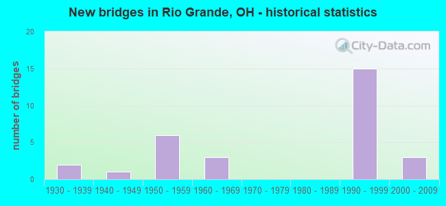
- New bridges - historical statistics
- 21930-1939
- 11940-1949
- 61950-1959
- 31960-1969
- 151990-1999
- 32000-2009

- Reconstructed bridges - Historical Statistics
- 11970-1979
- 21980-1989


- Bridge Condition - Deck
- 3.7%Excellent
- 33.3%Very good
- 33.3%Good
- 18.5%Satisfactory
- 7.4%Fair
- 3.7%Poor

- Bridge Condition - Superstructure
- 25.9%Very good
- 48.1%Good
- 14.8%Satisfactory
- 11.1%Fair

- Bridge Condition - Substructure
- 22.2%Very good
- 40.7%Good
- 22.2%Satisfactory
- 14.8%Fair

- Bridge Condition - Channel
- 30.8%Very good
- 30.8%Good
- 26.9%Satisfactory
- 11.5%Fair
Find on map >> Show street view
Structure Number: 2700786, Location: 1.68M W OF JCT SR325 (Lat: 38.874089, Lng: -82.356239), Route carried "on" structure: State highway 588, Year Built: 1956, Status: Open, Structure Length: 5.64m (18.50ft), Average Daily Traffic: 5,285 (year 2015), Truck Traffic: 6%, Average Future Daily Traffic: 7,336 (year 2035), Design Load: HS 20+Mod, Features Intersected: RACCOON CREEK
Minimum Vertical Clearance: 30+ m (98+ ft), Kilometerpoint: 2.720, Lanes on structure: 2, Owner: State Highway Agency, Approaching Roadway Width: 12.2m (40.0ft), Skew: 1 degrees, Material/Design: Steel continuous, Design/Construction: Stringer/Multi-beam, Number Of Spans In Main Unit: 3, Length of Maximum Span: 21.3m (69.9ft), Curb-To-Curb Width: 10.3m (33.8ft), Out-to-Out Width: 10.3m (33.8ft)
Condition: Deck: Very good, Superstructure: Satisfactory, Substructure: Good, Channel: Very good, Operating Rating: 42.1 metric tons, Method Used To Determine Operating Rating: Load Factor (LF) rating reported by rating factor (RF) method using MS18 loading, Inventory Rating: 32.4 metric tons, Method Used To Determine Inventory Rating: Load Factor (LF) rating reported by rating factor (RF) method using MS18 loading, Structural Evaluation: Equal to present minimum criteria, Deck Geometry: Meets minimum limits, Waterway Adequacy: Equal to present minimum criteria, Approach Roadway Alignment: Equal to present desirable criteria, Length Of Structure Improvement: 5.64m (18.50ft), Designated Inspection Frequency: Every 12 months, Inspection Date: April 2021, Bridge Improvement Cost: $500,000, Roadway Improvement Cost: $36,000, Total Project Cost: $536,000, Deck Structure Type: Concrete Cast-file-Place, Wearing Surface/Protective System: Wearing Surface: Monolithic Concrete
Find on map >> Show street view
Structure Number: 2700808, Location: .25 MI.E.JCT.SR 325 (Lat: 38.893039, Lng: -82.378689), Route carried "on" structure: US 35, Year Built: 1990, Status: Open, Structure Length: 3.17m (10.40ft), Average Daily Traffic: 6,839 (year 2015), Truck Traffic: 35%, Average Future Daily Traffic: 9,493 (year 2035), Design Load: HS 20, Features Intersected: LITTLE INDIAN CREEK
Minimum Vertical Clearance: 30+ m (98+ ft), Kilometerpoint: 7.033, Lanes on structure: 2, Base Highway Network: Yes, Owner: State Highway Agency, Approaching Roadway Width: 14.6m (47.9ft), Skew: 1 degrees, Material/Design: Concrete continuous, Design/Construction: Slab, Number Of Spans In Main Unit: 3, Length of Maximum Span: 11.9m (39.0ft), Curb-To-Curb Width: 14.8m (48.6ft), Out-to-Out Width: 15.7m (51.5ft)
Condition: Deck: Very good, Superstructure: Very good, Substructure: Good, Channel: Very good, Operating Rating: 42.1 metric tons, Method Used To Determine Operating Rating: Load Factor (LF) rating reported by rating factor (RF) method using MS18 loading, Inventory Rating: 32.4 metric tons, Method Used To Determine Inventory Rating: Load Factor (LF) rating reported by rating factor (RF) method using MS18 loading, Structural Evaluation: Better than present minimum criteria, Deck Geometry: Superior to present desirable criteria, Waterway Adequacy: Superior to present desirable criteria, Approach Roadway Alignment: Equal to present desirable criteria, Designated Inspection Frequency: Every 24 months, Inspection Date: April 2021, Deck Structure Type: Concrete Cast-file-Place, Wearing Surface/Protective System: Wearing Surface: Monolithic Concrete, Membrane: Epoxy, Deck Protection: Epoxy Coated Reinforcing
Find on map >> Show street view
Structure Number: 2700816, Location: 2.85M W OF JCT SR325 (Lat: 38.860569, Lng: -82.343550), Route carried "on" structure: State highway 588, Year Built: 1950, Year Reconstructed: 1992, Status: Open, Structure Length: 4.11m (13.48ft), Average Daily Traffic: 5,285 (year 2015), Truck Traffic: 6%, Average Future Daily Traffic: 7,336 (year 2035), Design Load: HS 20, Features Intersected: RYAN RUN
Minimum Vertical Clearance: 30+ m (98+ ft), Kilometerpoint: 4.619, Lanes on structure: 2, Owner: State Highway Agency, Approaching Roadway Width: 9.8m (32.2ft), Skew: 2 degrees, Material/Design: Steel continuous, Design/Construction: Stringer/Multi-beam, Number Of Spans In Main Unit: 3, Length of Maximum Span: 15.2m (49.9ft), Curb-To-Curb Width: 10.4m (34.1ft), Out-to-Out Width: 10.4m (34.1ft)
Condition: Deck: Good, Superstructure: Good, Substructure: Good, Channel: Very good, Operating Rating: 42.1 metric tons, Method Used To Determine Operating Rating: Allowable Stress (AS) rating reported by rating factor (RF) method using MS18 loading, Inventory Rating: 32.4 metric tons, Method Used To Determine Inventory Rating: Allowable Stress (AS) rating reported by rating factor (RF) method using MS18 loading, Structural Evaluation: Better than present minimum criteria, Deck Geometry: Meets minimum limits, Waterway Adequacy: Equal to present desirable criteria, Approach Roadway Alignment: Equal to present minimum criteria, Designated Inspection Frequency: Every 24 months, Inspection Date: April 2021, Deck Structure Type: Concrete Cast-file-Place, Wearing Surface/Protective System: Wearing Surface: Monolithic Concrete, Membrane: Epoxy, Deck Protection: Epoxy Coated Reinforcing
Find on map >> Show street view
Structure Number: 2700824, Location: .25 MI.E.JCT.SR 325 (Lat: 38.892789, Lng: -82.378469), Route carried "on" structure: US 35, Year Built: 1990, Status: Open, Structure Length: 3.17m (10.40ft), Average Daily Traffic: 6,839 (year 2015), Truck Traffic: 35%, Average Future Daily Traffic: 9,493 (year 2035), Design Load: HS 20, Features Intersected: LITTLE INDIAN CREEK
Minimum Vertical Clearance: 30+ m (98+ ft), Kilometerpoint: 7.033, Lanes on structure: 2, Base Highway Network: Yes, Owner: State Highway Agency, Approaching Roadway Width: 14.6m (47.9ft), Skew: 1 degrees, Material/Design: Concrete continuous, Design/Construction: Slab, Number Of Spans In Main Unit: 3, Length of Maximum Span: 11.9m (39.0ft), Curb-To-Curb Width: 14.8m (48.6ft), Out-to-Out Width: 15.7m (51.5ft)
Condition: Deck: Very good, Superstructure: Very good, Substructure: Good, Channel: Very good, Operating Rating: 42.1 metric tons, Method Used To Determine Operating Rating: Allowable Stress (AS) rating reported by rating factor (RF) method using MS18 loading, Inventory Rating: 32.4 metric tons, Method Used To Determine Inventory Rating: Allowable Stress (AS) rating reported by rating factor (RF) method using MS18 loading, Structural Evaluation: Better than present minimum criteria, Deck Geometry: Superior to present desirable criteria, Waterway Adequacy: Superior to present desirable criteria, Approach Roadway Alignment: Equal to present desirable criteria, Designated Inspection Frequency: Every 24 months, Inspection Date: April 2021, Deck Structure Type: Concrete Cast-file-Place, Wearing Surface/Protective System: Wearing Surface: Monolithic Concrete, Membrane: Epoxy, Deck Protection: Epoxy Coated Reinforcing
Find on map >> Show street view
Structure Number: 2700832, Location: 3.1 MI.E.JCT.SR325 (Lat: 38.882169, Lng: -82.329231), Route carried "on" structure: County highway CR33, Year Built: 1990, Status: Open, Structure Length: 7.83m (25.69ft), Average Daily Traffic: 99 (year 2015), Truck Traffic: 7%, Average Future Daily Traffic: 17,578 (year 2035), Design Load: HS 20, Features Intersected: USR 35, Facility Carried by Structure: CO.RD. 33
Minimum Vertical Clearance: 30+ m (98+ ft), Kilometerpoint: 0.322, Lanes on structure: 2, Lanes under structure: 4, Owner: State Highway Agency, Approaching Roadway Width: 8.5m (27.9ft), Material/Design: Steel continuous, Design/Construction: Stringer/Multi-beam, Number Of Spans In Main Unit: 2, Length of Maximum Span: 39.6m (129.9ft), Curb-To-Curb Width: 8.5m (27.9ft), Out-to-Out Width: 9.4m (30.8ft)
Condition: Deck: Very good, Superstructure: Very good, Substructure: Very good, Operating Rating: 42.1 metric tons, Method Used To Determine Operating Rating: Load Factor (LF) rating reported by rating factor (RF) method using MS18 loading, Inventory Rating: 32.4 metric tons, Method Used To Determine Inventory Rating: Load Factor (LF) rating reported by rating factor (RF) method using MS18 loading, Structural Evaluation: Equal to present desirable criteria, Deck Geometry: Better than present minimum criteria, Underclear: High priority of corrective action, Approach Roadway Alignment: Equal to present desirable criteria, Designated Inspection Frequency: Every 24 months, Inspection Date: April 2021, Deck Structure Type: Concrete Cast-file-Place, Wearing Surface/Protective System: Wearing Surface: Monolithic Concrete, Membrane: Epoxy, Deck Protection: Epoxy Coated Reinforcing
Find on map >> Show street view
Structure Number: 270084, Location: 1.96M E OF JCT SR850 (Lat: 38.858431, Lng: -82.337361), Route carried "on" structure: State highway 588, Year Built: 1950, Status: Open, Structure Length: 3.05m (10.01ft), Average Daily Traffic: 5,285 (year 2015), Truck Traffic: 6%, Average Future Daily Traffic: 7,336 (year 2035), Design Load: H 15, Features Intersected: RYAN RUN
Minimum Vertical Clearance: 30+ m (98+ ft), Kilometerpoint: 5.214, Lanes on structure: 2, Owner: State Highway Agency, Approaching Roadway Width: 10.4m (34.1ft), Skew: 3 degrees, Material/Design: Concrete continuous, Design/Construction: Slab, Number Of Spans In Main Unit: 3, Length of Maximum Span: 11.6m (38.1ft), Curb-To-Curb Width: 10.4m (34.1ft), Out-to-Out Width: 10.4m (34.1ft)
Condition: Deck: Fair, Superstructure: Satisfactory, Substructure: Satisfactory, Channel: Very good, Operating Rating: 32.4 metric tons, Method Used To Determine Operating Rating: Load Factor (LF) rating reported by rating factor (RF) method using MS18 loading, Inventory Rating: 25.9 metric tons, Method Used To Determine Inventory Rating: Load Factor (LF) rating reported by rating factor (RF) method using MS18 loading, Structural Evaluation: Equal to present minimum criteria, Deck Geometry: Meets minimum limits, Waterway Adequacy: Equal to present desirable criteria, Approach Roadway Alignment: Equal to present desirable criteria, Designated Inspection Frequency: Every 12 months, Inspection Date: April 2021, Deck Structure Type: Concrete Cast-file-Place, Wearing Surface/Protective System: Wearing Surface: Latex Concrete, Membrane: Epoxy
Find on map >> Show street view
Structure Number: 2700859, Location: 1.35 MI.E.JCT.SR 325 (Lat: 38.892011, Lng: -82.358561), Route carried "on" structure: US 35, Year Built: 1990, Status: Open, Structure Length: 7.99m (26.21ft), Average Daily Traffic: 6,332 (year 2015), Truck Traffic: 38%, Average Future Daily Traffic: 8,789 (year 2035), Design Load: HS 20, Features Intersected: RACCOON CREEK
Minimum Vertical Clearance: 30+ m (98+ ft), Kilometerpoint: 8.803, Lanes on structure: 2, Base Highway Network: Yes, Owner: State Highway Agency, Approaching Roadway Width: 11.9m (39.0ft), Skew: 2 degrees, Material/Design: Steel continuous, Design/Construction: Stringer/Multi-beam, Number Of Spans In Main Unit: 3, Length of Maximum Span: 30.5m (100.1ft), Curb-To-Curb Width: 12.2m (40.0ft), Out-to-Out Width: 12.7m (41.7ft)
Condition: Deck: Good, Superstructure: Good, Substructure: Good, Channel: Very good, Operating Rating: 46.3 metric tons, Method Used To Determine Operating Rating: Load and Resistance Factor Rating (LRFR) rating reported by rating factor(RF) method using HL-93 loadings, Inventory Rating: 36.0 metric tons, Method Used To Determine Inventory Rating: Load and Resistance Factor Rating (LRFR) rating reported by rating factor(RF) method using HL-93 loadings, Structural Evaluation: Better than present minimum criteria, Deck Geometry: Better than present minimum criteria, Waterway Adequacy: Superior to present desirable criteria, Approach Roadway Alignment: Equal to present desirable criteria, Designated Inspection Frequency: Every 24 months, Inspection Date: October 2021, Deck Structure Type: Concrete Cast-file-Place, Wearing Surface/Protective System: Wearing Surface: Monolithic Concrete, Membrane: Epoxy, Deck Protection: Epoxy Coated Reinforcing
Find on map >> Show street view
Structure Number: 2700867, Location: 1.35 MI.E.JCT.SR 325 (Lat: 38.891850, Lng: -82.358800), Route carried "on" structure: US 35, Year Built: 1990, Status: Open, Structure Length: 7.99m (26.21ft), Average Daily Traffic: 6,332 (year 2015), Truck Traffic: 38%, Average Future Daily Traffic: 8,789 (year 2035), Design Load: HS 20, Features Intersected: RACCOON CREEK
Minimum Vertical Clearance: 30+ m (98+ ft), Kilometerpoint: 8.803, Lanes on structure: 2, Base Highway Network: Yes, Owner: State Highway Agency, Approaching Roadway Width: 11.9m (39.0ft), Skew: 2 degrees, Material/Design: Steel continuous, Design/Construction: Stringer/Multi-beam, Number Of Spans In Main Unit: 3, Length of Maximum Span: 30.5m (100.1ft), Curb-To-Curb Width: 12.2m (40.0ft), Out-to-Out Width: 12.7m (41.7ft)
Condition: Deck: Good, Superstructure: Good, Substructure: Very good, Channel: Very good, Operating Rating: 46.3 metric tons, Method Used To Determine Operating Rating: Load and Resistance Factor Rating (LRFR) rating reported by rating factor(RF) method using HL-93 loadings, Inventory Rating: 36.0 metric tons, Method Used To Determine Inventory Rating: Load and Resistance Factor Rating (LRFR) rating reported by rating factor(RF) method using HL-93 loadings, Structural Evaluation: Better than present minimum criteria, Deck Geometry: Better than present minimum criteria, Waterway Adequacy: Superior to present desirable criteria, Approach Roadway Alignment: Equal to present desirable criteria, Designated Inspection Frequency: Every 24 months, Inspection Date: October 2021, Deck Structure Type: Concrete Cast-file-Place, Wearing Surface/Protective System: Wearing Surface: Monolithic Concrete, Membrane: Epoxy, Deck Protection: Epoxy Coated Reinforcing
Find on map >> Show street view
Structure Number: 2700875, Location: 1.2 MI.W. JCT. SR 588 (Lat: 38.856819, Lng: -82.331261), Route carried "on" structure: State highway 588, Year Built: 1950, Year Reconstructed: 1992, Status: Open, Structure Length: 1.55m (5.09ft), Average Daily Traffic: 5,285 (year 2015), Truck Traffic: 6%, Average Future Daily Traffic: 7,336 (year 2035), Design Load: HS 20, Features Intersected: RYAN RUN
Minimum Vertical Clearance: 30+ m (98+ ft), Kilometerpoint: 5.778, Lanes on structure: 2, Owner: State Highway Agency, Approaching Roadway Width: 9.8m (32.2ft), Skew: 3 degrees, Material/Design: Steel, Design/Construction: Stringer/Multi-beam, Number Of Spans In Main Unit: 1, Length of Maximum Span: 13.4m (44.0ft), Curb-To-Curb Width: 10.4m (34.1ft), Out-to-Out Width: 10.4m (34.1ft)
Condition: Deck: Very good, Superstructure: Good, Substructure: Good, Channel: Satisfactory, Operating Rating: 42.1 metric tons, Method Used To Determine Operating Rating: Allowable Stress (AS) rating reported by rating factor (RF) method using MS18 loading, Inventory Rating: 32.4 metric tons, Method Used To Determine Inventory Rating: Allowable Stress (AS) rating reported by rating factor (RF) method using MS18 loading, Structural Evaluation: Better than present minimum criteria, Deck Geometry: Meets minimum limits, Waterway Adequacy: Equal to present desirable criteria, Approach Roadway Alignment: Equal to present minimum criteria, Designated Inspection Frequency: Every 24 months, Inspection Date: April 2021, Deck Structure Type: Concrete Cast-file-Place, Wearing Surface/Protective System: Wearing Surface: Monolithic Concrete, Membrane: Epoxy, Deck Protection: Epoxy Coated Reinforcing
Find on map >> Show street view
Structure Number: 2703432, Location: 3.37MI S.OF JCT.SR.141 (Lat: 38.840311, Lng: -82.392661), Route carried "on" structure: State highway 325, Year Built: 2003, Status: Open, Structure Length: 1.01m (3.31ft), Average Daily Traffic: 1,149 (year 2015), Truck Traffic: 6%, Average Future Daily Traffic: 1,595 (year 2035), Design Load: HS 20+Mod, Features Intersected: OVER LITTLE BEAVER CREEK
Minimum Vertical Clearance: 30+ m (98+ ft), Kilometerpoint: 5.375, Lanes on structure: 2, Owner: State Highway Agency, Approaching Roadway Width: 10.1m (33.1ft), Skew: 1 degrees, Material/Design: Concrete, Design/Construction: Culvert, Number Of Spans In Main Unit: 1, Length of Maximum Span: 9.4m (30.8ft)
Condition: Channel: Good, Culverts: Very good, Operating Rating: 81.0 metric tons, Method Used To Determine Operating Rating: Load Factor (LF) rating reported by rating factor (RF) method using MS18 loading, Inventory Rating: 77.8 metric tons, Method Used To Determine Inventory Rating: Load Factor (LF) rating reported by rating factor (RF) method using MS18 loading, Structural Evaluation: Equal to present desirable criteria, Waterway Adequacy: Equal to present desirable criteria, Approach Roadway Alignment: Equal to present minimum criteria, Designated Inspection Frequency: Every 24 months, Inspection Date: April 2021
Find on map >> Show street view
Structure Number: 2703467, Location: 3.78MI S.JCT.SR.141 (Lat: 38.845831, Lng: -82.389989), Route carried "on" structure: State highway 325, Year Built: 2003, Status: Open, Structure Length: 2.07m (6.79ft), Average Daily Traffic: 1,149 (year 2015), Truck Traffic: 7%, Average Future Daily Traffic: 1,595 (year 2035), Design Load: HS 20+Mod, Features Intersected: OVER BIG BEAVER CREEK
Minimum Vertical Clearance: 30+ m (98+ ft), Kilometerpoint: 6.035, Lanes on structure: 2, Owner: State Highway Agency, Approaching Roadway Width: 9.1m (29.9ft), Skew: 2 degrees, Material/Design: Concrete continuous, Design/Construction: Slab, Number Of Spans In Main Unit: 3, Length of Maximum Span: 20.1m (65.9ft), Curb-To-Curb Width: 9.1m (29.9ft), Out-to-Out Width: 9.1m (29.9ft)
Condition: Deck: Good, Superstructure: Very good, Substructure: Very good, Channel: Satisfactory, Operating Rating: 42.1 metric tons, Method Used To Determine Operating Rating: Load Factor (LF) rating reported by rating factor (RF) method using MS18 loading, Inventory Rating: 32.4 metric tons, Method Used To Determine Inventory Rating: Load Factor (LF) rating reported by rating factor (RF) method using MS18 loading, Structural Evaluation: Equal to present desirable criteria, Deck Geometry: Somewhat better than minimum adequacy, Waterway Adequacy: Equal to present desirable criteria, Approach Roadway Alignment: Equal to present minimum criteria, Designated Inspection Frequency: Every 24 months, Inspection Date: April 2021, Deck Structure Type: Concrete Cast-file-Place, Wearing Surface/Protective System: Wearing Surface: Monolithic Concrete, Membrane: Epoxy, Deck Protection: Epoxy Coated Reinforcing
Find on map >> Show street view
Structure Number: 2703491, Location: 0.4 MI. S. JCT SR 554 (Lat: 38.888961, Lng: -82.382381), Route carried "on" structure: State highway 325, Year Built: 1990, Status: Open, Structure Length: 4.21m (13.81ft), Average Daily Traffic: 7,288 (year 2015), Truck Traffic: 6%, Average Future Daily Traffic: 10,116 (year 2035), Design Load: HS 20, Features Intersected: INDIAN CREEK
Minimum Vertical Clearance: 30+ m (98+ ft), Kilometerpoint: 11.121, Lanes on structure: 2, Owner: State Highway Agency, Approaching Roadway Width: 13.4m (44.0ft), Material/Design: Steel continuous, Design/Construction: Stringer/Multi-beam, Number Of Spans In Main Unit: 3, Length of Maximum Span: 15.9m (52.2ft), Curb-To-Curb Width: 13.5m (44.3ft), Out-to-Out Width: 14.0m (45.9ft)
Condition: Deck: Very good, Superstructure: Good, Substructure: Good, Channel: Fair, Operating Rating: 42.1 metric tons, Method Used To Determine Operating Rating: Load Factor (LF) rating reported by rating factor (RF) method using MS18 loading, Inventory Rating: 32.4 metric tons, Method Used To Determine Inventory Rating: Load Factor (LF) rating reported by rating factor (RF) method using MS18 loading, Structural Evaluation: Better than present minimum criteria, Deck Geometry: Superior to present desirable criteria, Waterway Adequacy: Superior to present desirable criteria, Approach Roadway Alignment: Equal to present desirable criteria, Designated Inspection Frequency: Every 24 months, Inspection Date: April 2021, Deck Structure Type: Concrete Cast-file-Place, Wearing Surface/Protective System: Wearing Surface: Monolithic Concrete, Membrane: Epoxy, Deck Protection: Epoxy Coated Reinforcing
Find on map >> Show street view
Structure Number: 2703521, Location: 0.2 MI. S JCT SR 554 (Lat: 38.891189, Lng: -82.382581), Route carried "on" structure: State highway 325, Year Built: 1990, Status: Open, Structure Length: 7.38m (24.21ft), Average Daily Traffic: 5,491 (year 2015), Truck Traffic: 6%, Average Future Daily Traffic: 7,622 (year 2035), Design Load: HS 20, Features Intersected: U.S.R. 35
Minimum Vertical Clearance: 30+ m (98+ ft), Kilometerpoint: 11.330, Lanes on structure: 2, Lanes under structure: 4, Owner: State Highway Agency, Approaching Roadway Width: 13.4m (44.0ft), Skew: 2 degrees, Material/Design: Steel continuous, Design/Construction: Stringer/Multi-beam, Number Of Spans In Main Unit: 2, Length of Maximum Span: 36.6m (120.1ft), Curb-To-Curb Width: 13.4m (44.0ft), Out-to-Out Width: 14.0m (45.9ft)
Condition: Deck: Good, Superstructure: Very good, Substructure: Very good, Operating Rating: 42.1 metric tons, Method Used To Determine Operating Rating: Load Factor (LF) rating reported by rating factor (RF) method using MS18 loading, Inventory Rating: 32.4 metric tons, Method Used To Determine Inventory Rating: Load Factor (LF) rating reported by rating factor (RF) method using MS18 loading, Structural Evaluation: Equal to present desirable criteria, Deck Geometry: Equal to present minimum criteria, Underclear: Meets minimum limits, Approach Roadway Alignment: Superior to present desirable criteria, Designated Inspection Frequency: Every 24 months, Inspection Date: April 2021, Deck Structure Type: Concrete Cast-file-Place, Wearing Surface/Protective System: Wearing Surface: Monolithic Concrete, Membrane: Epoxy, Deck Protection: Epoxy Coated Reinforcing
Find on map >> Show street view
Structure Number: 2703548, Location: .02 MI S OF JCT SR 554 (Lat: 38.892311, Lng: -82.382639), Route carried "on" structure: State highway 325, Year Built: 1990, Status: Open, Structure Length: 4.21m (13.81ft), Average Daily Traffic: 3,693 (year 2015), Truck Traffic: 7%, Average Future Daily Traffic: 5,126 (year 2035), Design Load: HS 20, Features Intersected: LITTLE INDIAN CREEK
Minimum Vertical Clearance: 30+ m (98+ ft), Kilometerpoint: 11.475, Lanes on structure: 2, Owner: State Highway Agency, Approaching Roadway Width: 13.4m (44.0ft), Skew: 1 degrees, Material/Design: Steel continuous, Design/Construction: Stringer/Multi-beam, Number Of Spans In Main Unit: 3, Length of Maximum Span: 15.9m (52.2ft), Curb-To-Curb Width: 13.4m (44.0ft), Out-to-Out Width: 14.0m (45.9ft)
Condition: Deck: Very good, Superstructure: Very good, Substructure: Very good, Channel: Very good, Operating Rating: 42.1 metric tons, Method Used To Determine Operating Rating: Load Factor (LF) rating reported by rating factor (RF) method using MS18 loading, Inventory Rating: 32.4 metric tons, Method Used To Determine Inventory Rating: Load Factor (LF) rating reported by rating factor (RF) method using MS18 loading, Structural Evaluation: Equal to present desirable criteria, Deck Geometry: Better than present minimum criteria, Waterway Adequacy: Equal to present minimum criteria, Approach Roadway Alignment: Better than present minimum criteria, Designated Inspection Frequency: Every 24 months, Inspection Date: April 2021, Deck Structure Type: Concrete Cast-file-Place, Wearing Surface/Protective System: Wearing Surface: Monolithic Concrete, Membrane: Epoxy, Deck Protection: Epoxy Coated Reinforcing
Find on map >> Show street view
Structure Number: 2703785, Location: 2.25M W OF JCT SR325 (Lat: 38.901400, Lng: -82.345250), Route carried "on" structure: State highway 554, Year Built: 1955, Year Reconstructed: 1977, Status: Open, Structure Length: 5.64m (18.50ft), Average Daily Traffic: 924 (year 2015), Truck Traffic: 8%, Average Future Daily Traffic: 1,283 (year 2035), Design Load: HS 20+Mod, Features Intersected: RACCOON CREEK
Minimum Vertical Clearance: 30+ m (98+ ft), Kilometerpoint: 3.621, Lanes on structure: 2, Owner: State Highway Agency, Approaching Roadway Width: 7.3m (24.0ft), Material/Design: Steel continuous, Design/Construction: Stringer/Multi-beam, Number Of Spans In Main Unit: 3, Length of Maximum Span: 21.3m (69.9ft), Curb-To-Curb Width: 7.6m (24.9ft), Out-to-Out Width: 7.6m (24.9ft)
Condition: Deck: Good, Superstructure: Satisfactory, Substructure: Satisfactory, Channel: Good, Operating Rating: 42.1 metric tons, Method Used To Determine Operating Rating: Load Factor (LF) rating reported by rating factor (RF) method using MS18 loading, Inventory Rating: 32.4 metric tons, Method Used To Determine Inventory Rating: Load Factor (LF) rating reported by rating factor (RF) method using MS18 loading, Structural Evaluation: Equal to present minimum criteria, Deck Geometry: Meets minimum limits, Waterway Adequacy: Superior to present desirable criteria, Approach Roadway Alignment: Equal to present desirable criteria, Designated Inspection Frequency: Every 12 months, Inspection Date: April 2021, Deck Structure Type: Concrete Cast-file-Place, Wearing Surface/Protective System: Wearing Surface: Monolithic Concrete
Find on map >> Show street view
Structure Number: 2703815, Location: 3.97M W OF JCT SR325 (Lat: 38.903239, Lng: -82.320589), Route carried "on" structure: State highway 554, Year Built: 1946, Status: Open, Structure Length: 4.02m (13.19ft), Average Daily Traffic: 924 (year 2015), Truck Traffic: 8%, Average Future Daily Traffic: 1,283 (year 2035), Design Load: H 10, Features Intersected: BARREN CREEK
Minimum Vertical Clearance: 30+ m (98+ ft), Kilometerpoint: 6.389, Lanes on structure: 2, Owner: State Highway Agency, Approaching Roadway Width: 7.9m (25.9ft), Material/Design: Steel continuous, Design/Construction: Stringer/Multi-beam, Number Of Spans In Main Unit: 3, Length of Maximum Span: 15.2m (49.9ft), Curb-To-Curb Width: 7.8m (25.6ft), Out-to-Out Width: 8.1m (26.6ft)
Condition: Deck: Fair, Superstructure: Good, Substructure: Good, Channel: Satisfactory, Operating Rating: 25.9 metric tons, Method Used To Determine Operating Rating: Load Factor (LF) rating reported by rating factor (RF) method using MS18 loading, Inventory Rating: 19.4 metric tons, Method Used To Determine Inventory Rating: Load Factor (LF) rating reported by rating factor (RF) method using MS18 loading, Structural Evaluation: Somewhat better than minimum adequacy, Deck Geometry: Meets minimum limits, Waterway Adequacy: Better than present minimum criteria, Approach Roadway Alignment: Equal to present minimum criteria, Designated Inspection Frequency: Every 12 months, Inspection Date: April 2021, Deck Structure Type: Concrete Cast-file-Place, Wearing Surface/Protective System: Wearing Surface: Bituminous, Membrane: Preformed Fabric
Find on map >> Show street view
Structure Number: 2741725, Location: 250 FT S OF CORA MILL RD (Lat: 38.841311, Lng: -82.380139), Route carried "on" structure: County highway T0472, Year Built: 1933, Status: Posted for load, Structure Length: 1.01m (3.31ft), Average Daily Traffic: 209 (year 2015), Truck Traffic: 7%, Average Future Daily Traffic: 290 (year 2035), Features Intersected: BEAVER CREEK, Facility Carried by Structure: GUTHRIE RD
Minimum Vertical Clearance: 30+ m (98+ ft), Kilometerpoint: 0.064, Lanes on structure: 1, Owner: County Highway Agency, Approaching Roadway Width: 3.0m (9.8ft), Material/Design: Steel, Design/Construction: Girder and Floorbeam System, Number Of Spans In Main Unit: 1, Length of Maximum Span: 9.4m (30.8ft), Curb-To-Curb Width: 4.3m (14.1ft), Out-to-Out Width: 4.3m (14.1ft)
Condition: Deck: Satisfactory, Superstructure: Fair, Substructure: Fair, Channel: Good, Operating Rating: 22.7 metric tons, Method Used To Determine Operating Rating: Load Factor (LF) rating reported by rating factor (RF) method using MS18 loading, Inventory Rating: 13.0 metric tons, Method Used To Determine Inventory Rating: Load Factor (LF) rating reported by rating factor (RF) method using MS18 loading, Structural Evaluation: Meets minimum limits, Deck Geometry: High priority of replacement, Waterway Adequacy: Equal to present minimum criteria, Approach Roadway Alignment: Somewhat better than minimum adequacy, Bridge Posting: Required (Relationship of Operating Rating to Maximum Legal Load: > 39.9% below), Designated Inspection Frequency: Every 12 months, Critical Feature Inspection Frequency: Every 24 months, Inspection Date: August 2021, Critical Feature Inspection Date: July 2020, Deck Structure Type: Wood or Timber, Wearing Surface/Protective System: Wearing Surface: Wood or Timber
Find on map >> Show street view
Structure Number: 2741784, Location: 500 FT E OF CREEKVIEW DR (Lat: 38.835169, Lng: -82.371031), Route carried "on" structure: County highway C0012, Year Built: 1965, Status: Open, Structure Length: 1.49m (4.89ft), Average Daily Traffic: 175 (year 2015), Truck Traffic: 7%, Average Future Daily Traffic: 243 (year 2035), Design Load: H 20, Features Intersected: BEAVER CREEK, Facility Carried by Structure: CORA MILL RD
Minimum Vertical Clearance: 30+ m (98+ ft), Kilometerpoint: 2.478, Lanes on structure: 1, Owner: County Highway Agency, Approaching Roadway Width: 6.1m (20.0ft), Material/Design: Steel, Design/Construction: Stringer/Multi-beam, Number Of Spans In Main Unit: 1, Length of Maximum Span: 14.6m (47.9ft), Curb-To-Curb Width: 6.0m (19.7ft), Out-to-Out Width: 6.3m (20.7ft)
Condition: Deck: Very good, Superstructure: Good, Substructure: Good, Channel: Satisfactory, Operating Rating: 42.1 metric tons, Method Used To Determine Operating Rating: Load Factor (LF) rating reported by rating factor (RF) method using MS18 loading, Inventory Rating: 32.4 metric tons, Method Used To Determine Inventory Rating: Load Factor (LF) rating reported by rating factor (RF) method using MS18 loading, Structural Evaluation: Better than present minimum criteria, Deck Geometry: High priority of corrective action, Waterway Adequacy: Better than present minimum criteria, Approach Roadway Alignment: Equal to present minimum criteria, Designated Inspection Frequency: Every 24 months, Inspection Date: August 2021, Deck Structure Type: Corrugated Steel, Wearing Surface/Protective System: Wearing Surface: Integral Concrete
Find on map >> Show street view
Structure Number: 2741806, Location: .95 MI S OF S R 141 (Lat: 38.820250, Lng: -82.343189), Route carried "on" structure: County highway CO016, Year Built: 1965, Status: Posted for load, Structure Length: 0.82m (2.69ft), Average Daily Traffic: 209 (year 2015), Truck Traffic: 7%, Average Future Daily Traffic: 290 (year 2035), Design Load: HS 20+Mod, Features Intersected: MUD CREEK, Facility Carried by Structure: MUD CREEK RD
Minimum Vertical Clearance: 30+ m (98+ ft), Kilometerpoint: 1.529, Lanes on structure: 1, Owner: County Highway Agency, Approaching Roadway Width: 3.0m (9.8ft), Skew: 1 degrees, Material/Design: Steel, Design/Construction: Stringer/Multi-beam, Number Of Spans In Main Unit: 1, Length of Maximum Span: 7.6m (24.9ft), Curb-To-Curb Width: 4.1m (13.5ft), Out-to-Out Width: 4.3m (14.1ft)
Condition: Deck: Good, Superstructure: Fair, Substructure: Fair, Channel: Satisfactory, Operating Rating: 48.6 metric tons, Method Used To Determine Operating Rating: Load Factor (LF) rating reported by rating factor (RF) method using MS18 loading, Inventory Rating: 29.2 metric tons, Method Used To Determine Inventory Rating: Load Factor (LF) rating reported by rating factor (RF) method using MS18 loading, Structural Evaluation: Somewhat better than minimum adequacy, Deck Geometry: High priority of replacement, Waterway Adequacy: Somewhat better than minimum adequacy, Approach Roadway Alignment: Somewhat better than minimum adequacy, Bridge Posting: Required (Relationship of Operating Rating to Maximum Legal Load: 20.0 - 29.9% below), Designated Inspection Frequency: Every 12 months, Inspection Date: August 2021, Deck Structure Type: Corrugated Steel, Wearing Surface/Protective System: Wearing Surface: Monolithic Concrete
Find on map >> Show street view
Structure Number: 2741822, Location: 20'E.OF MAPLE GROVE RD. (Lat: 38.825111, Lng: -82.369169), Route carried "on" structure: County highway C0012, Year Built: 2007, Status: Open, Structure Length: 7.44m (24.41ft), Average Daily Traffic: 175 (year 2015), Truck Traffic: 7%, Average Future Daily Traffic: 243 (year 2035), Design Load: H 20, Features Intersected: RACCOON CREEK, Facility Carried by Structure: COUNTY RD 12
Minimum Vertical Clearance: 30+ m (98+ ft), Kilometerpoint: 3.814, Lanes on structure: 2, Owner: County Highway Agency, Approaching Roadway Width: 7.6m (24.9ft), Material/Design: Prestressed concrete continuous, Design/Construction: Stringer/Multi-beam, Number Of Spans In Main Unit: 3, Length of Maximum Span: 24.4m (80.1ft), Curb-To-Curb Width: 8.5m (27.9ft), Out-to-Out Width: 8.5m (27.9ft)
Condition: Deck: Very good, Superstructure: Very good, Substructure: Very good, Channel: Good, Operating Rating: 42.1 metric tons, Method Used To Determine Operating Rating: Load Factor (LF) rating reported by rating factor (RF) method using MS18 loading, Inventory Rating: 32.4 metric tons, Method Used To Determine Inventory Rating: Load Factor (LF) rating reported by rating factor (RF) method using MS18 loading, Structural Evaluation: Equal to present desirable criteria, Deck Geometry: Equal to present minimum criteria, Waterway Adequacy: Equal to present desirable criteria, Approach Roadway Alignment: Better than present minimum criteria, Designated Inspection Frequency: Every 24 months, Inspection Date: August 2021, Deck Structure Type: Concrete Cast-file-Place, Wearing Surface/Protective System: Wearing Surface: Monolithic Concrete
Find on map >> Show street view
Structure Number: 2742039, Location: 0.2 MI. WEST OF SR325 (Lat: 38.849689, Lng: -82.392611), Route carried "on" structure: County highway TO432, Year Built: 1998, Status: Open, Structure Length: 0.76m (2.49ft), Average Daily Traffic: 209 (year 2015), Truck Traffic: 7%, Average Future Daily Traffic: 290 (year 2035), Design Load: H 20, Features Intersected: CREEK, Facility Carried by Structure: HOLCOMB HOLLOW RD
Minimum Vertical Clearance: 30+ m (98+ ft), Kilometerpoint: 0.322, Lanes on structure: 1, Owner: County Highway Agency, Approaching Roadway Width: 4.6m (15.1ft), Material/Design: Steel, Design/Construction: Stringer/Multi-beam, Number Of Spans In Main Unit: 1, Length of Maximum Span: 7.0m (23.0ft), Curb-To-Curb Width: 5.8m (19.0ft), Out-to-Out Width: 5.8m (19.0ft)
Condition: Deck: Excellent, Superstructure: Good, Substructure: Satisfactory, Channel: Satisfactory, Operating Rating: 42.1 metric tons, Method Used To Determine Operating Rating: Load Factor (LF) rating reported by rating factor (RF) method using MS18 loading, Inventory Rating: 32.4 metric tons, Method Used To Determine Inventory Rating: Load Factor (LF) rating reported by rating factor (RF) method using MS18 loading, Structural Evaluation: Equal to present minimum criteria, Deck Geometry: High priority of corrective action, Waterway Adequacy: Better than present minimum criteria, Approach Roadway Alignment: Somewhat better than minimum adequacy, Designated Inspection Frequency: Every 12 months, Inspection Date: August 2021, Deck Structure Type: Wood or Timber, Wearing Surface/Protective System: Wearing Surface: Wood or Timber
Find on map >> Show street view
Structure Number: 274233, Location: 50 FT E OF CREEKVIEW DR (Lat: 38.859031, Lng: -82.361939), Route carried "on" structure: County highway TO420, Year Built: 1965, Status: Posted for load, Structure Length: 5.55m (18.21ft), Average Daily Traffic: 209 (year 2015), Truck Traffic: 7%, Average Future Daily Traffic: 290 (year 2035), Features Intersected: RACCOON CREEK, Facility Carried by Structure: GARNERS FORD RD
Minimum Vertical Clearance: 4.62m (15.16ft), Kilometerpoint: 0.000, Lanes on structure: 1, Owner: County Highway Agency, Approaching Roadway Width: 3.7m (12.1ft), Material/Design: Steel, Design/Construction: Truss - Thru, Number Of Spans In Main Unit: 1, Number Of Approach Spans: 3, Length of Maximum Span: 41.8m (137.1ft), Curb-To-Curb Width: 4.9m (16.1ft), Out-to-Out Width: 5.0m (16.4ft)
Condition: Deck: Poor, Superstructure: Fair, Substructure: Fair, Channel: Good, Operating Rating: 13.0 metric tons, Method Used To Determine Operating Rating: Load Factor (LF) rating reported by rating factor (RF) method using MS18 loading, Inventory Rating: 6.5 metric tons, Method Used To Determine Inventory Rating: Load Factor (LF) rating reported by rating factor (RF) method using MS18 loading, Structural Evaluation: High priority of corrective action, Deck Geometry: High priority of replacement, Waterway Adequacy: Equal to present minimum criteria, Approach Roadway Alignment: Equal to present minimum criteria, Bridge Posting: Required (Relationship of Operating Rating to Maximum Legal Load: > 39.9% below), Designated Inspection Frequency: Every 12 months, Critical Feature Inspection Frequency: Every 24 months, Inspection Date: August 2021, Critical Feature Inspection Date: July 2020, Deck Structure Type: Wood or Timber, Wearing Surface/Protective System: Wearing Surface: Wood or Timber
Find on map >> Show street view
Structure Number: 2742381, Location: .54 MI NW OF SR 588 (Lat: 38.860581, Lng: -82.336439), Route carried "on" structure: County highway CO065, Year Built: 1930, Status: Open, Structure Length: 0.73m (2.40ft), Average Daily Traffic: 385 (year 2015), Truck Traffic: 8%, Average Future Daily Traffic: 534 (year 2035), Features Intersected: STREAM, Facility Carried by Structure: AUTUMN HILL RD
Minimum Vertical Clearance: 30+ m (98+ ft), Kilometerpoint: 0.869, Lanes on structure: 1, Owner: County Highway Agency, Approaching Roadway Width: 4.6m (15.1ft), Material/Design: Concrete, Design/Construction: Slab, Number Of Spans In Main Unit: 1, Length of Maximum Span: 6.7m (22.0ft), Curb-To-Curb Width: 6.7m (22.0ft), Out-to-Out Width: 7.3m (24.0ft)
Condition: Deck: Satisfactory, Superstructure: Satisfactory, Substructure: Fair, Channel: Fair, Operating Rating: 40.8 metric tons, Method Used To Determine Operating Rating: Field evaluation and documented engineering judgment, Inventory Rating: 32.7 metric tons, Method Used To Determine Inventory Rating: Field evaluation and documented engineering judgment, Structural Evaluation: Somewhat better than minimum adequacy, Deck Geometry: Meets minimum limits, Waterway Adequacy: Better than present minimum criteria, Approach Roadway Alignment: Better than present minimum criteria, Designated Inspection Frequency: Every 12 months, Inspection Date: August 2021, Deck Structure Type: Concrete Cast-file-Place, Wearing Surface/Protective System: Wearing Surface: Bituminous
Find on map >> Show street view
Structure Number: 2742438, Location: 50'N.OF BUCKEYE HILLS (Lat: 38.893689, Lng: -82.384581), Route carried "on" structure: County highway CO091, Year Built: 1991, Status: Open, Structure Length: 2.87m (9.42ft), Average Daily Traffic: 140 (year 2015), Truck Traffic: 7%, Average Future Daily Traffic: 194 (year 2035), Design Load: HS 20+Mod, Features Intersected: LITTLE INDIAN CREEK, Facility Carried by Structure: PLEASANT VALLEY RD
Minimum Vertical Clearance: 30+ m (98+ ft), Kilometerpoint: 5.053, Lanes on structure: 2, Owner: County Highway Agency, Approaching Roadway Width: 9.1m (29.9ft), Skew: 1 degrees, Material/Design: Concrete continuous, Design/Construction: Slab, Number Of Spans In Main Unit: 3, Length of Maximum Span: 10.7m (35.1ft), Curb-To-Curb Width: 8.5m (27.9ft), Out-to-Out Width: 9.1m (29.9ft)
Condition: Deck: Good, Superstructure: Good, Substructure: Good, Channel: Good, Operating Rating: 42.1 metric tons, Method Used To Determine Operating Rating: Allowable Stress (AS) rating reported by rating factor (RF) method using MS18 loading, Inventory Rating: 32.4 metric tons, Method Used To Determine Inventory Rating: Allowable Stress (AS) rating reported by rating factor (RF) method using MS18 loading, Structural Evaluation: Better than present minimum criteria, Deck Geometry: Equal to present minimum criteria, Waterway Adequacy: Superior to present desirable criteria, Approach Roadway Alignment: Superior to present desirable criteria, Designated Inspection Frequency: Every 24 months, Inspection Date: August 2021, Deck Structure Type: Concrete Cast-file-Place, Wearing Surface/Protective System: Wearing Surface: Monolithic Concrete, Deck Protection: Epoxy Coated Reinforcing
Find on map >> Show street view
Structure Number: 2742462, Location: 500'S.OF DEER CREEK RD. (Lat: 38.940611, Lng: -82.398781), Route carried "on" structure: County highway CO089, Year Built: 1994, Status: Open, Structure Length: 0.98m (3.22ft), Average Daily Traffic: 134 (year 2015), Truck Traffic: 7%, Average Future Daily Traffic: 186 (year 2035), Design Load: H 20, Features Intersected: DEER CREEK, Facility Carried by Structure: MT TABOR ROAD
Minimum Vertical Clearance: 30+ m (98+ ft), Kilometerpoint: 1.915, Lanes on structure: 2, Owner: County Highway Agency, Approaching Roadway Width: 6.1m (20.0ft), Material/Design: Steel, Design/Construction: Stringer/Multi-beam, Number Of Spans In Main Unit: 1, Length of Maximum Span: 9.4m (30.8ft), Curb-To-Curb Width: 6.9m (22.6ft), Out-to-Out Width: 6.9m (22.6ft)
Condition: Deck: Satisfactory, Superstructure: Good, Substructure: Satisfactory, Channel: Satisfactory, Operating Rating: 42.1 metric tons, Method Used To Determine Operating Rating: Load Factor (LF) rating reported by rating factor (RF) method using MS18 loading, Inventory Rating: 32.4 metric tons, Method Used To Determine Inventory Rating: Load Factor (LF) rating reported by rating factor (RF) method using MS18 loading, Structural Evaluation: Equal to present minimum criteria, Deck Geometry: Meets minimum limits, Waterway Adequacy: Superior to present desirable criteria, Approach Roadway Alignment: Equal to present minimum criteria, Designated Inspection Frequency: Every 12 months, Inspection Date: August 2021, Deck Structure Type: Wood or Timber, Wearing Surface/Protective System: Wearing Surface: Bituminous
Find on map >> Show street view
Structure Number: 2742578, Location: .81 M W OF STATE RT 325 (Lat: 38.887811, Lng: -82.386311), Route carried "on" structure: County highway TO428, Year Built: 1956, Status: Open, Structure Length: 4.05m (13.29ft), Average Daily Traffic: 585 (year 2015), Truck Traffic: 8%, Average Future Daily Traffic: 812 (year 2035), Design Load: H 20, Features Intersected: INDIAN CREEK, Facility Carried by Structure: INDIAN CREEK RD
Minimum Vertical Clearance: 30+ m (98+ ft), Kilometerpoint: 1.304, Lanes on structure: 2, Owner: County Highway Agency, Approaching Roadway Width: 12.2m (40.0ft), Skew: 3 degrees, Material/Design: Steel continuous, Design/Construction: Stringer/Multi-beam, Number Of Spans In Main Unit: 3, Length of Maximum Span: 15.2m (49.9ft), Curb-To-Curb Width: 13.0m (42.7ft), Out-to-Out Width: 13.4m (44.0ft)
Condition: Deck: Satisfactory, Superstructure: Good, Substructure: Satisfactory, Channel: Good, Operating Rating: 42.1 metric tons, Method Used To Determine Operating Rating: Load Factor (LF) rating reported by rating factor (RF) method using MS18 loading, Inventory Rating: 32.4 metric tons, Method Used To Determine Inventory Rating: Load Factor (LF) rating reported by rating factor (RF) method using MS18 loading, Structural Evaluation: Equal to present minimum criteria, Deck Geometry: Superior to present desirable criteria, Waterway Adequacy: Superior to present desirable criteria, Approach Roadway Alignment: Superior to present desirable criteria, Designated Inspection Frequency: Every 12 months, Inspection Date: August 2021, Deck Structure Type: Concrete Cast-file-Place, Wearing Surface/Protective System: Wearing Surface: Latex Concrete
Find on map >> Show street view
Structure Number: 2742616, Location: 100'W.OF SR.325 325 (Lat: 38.893389, Lng: -82.383331), Route carried "on" structure: County highway CO079, Year Built: 1991, Status: Open, Structure Length: 3.17m (10.40ft), Average Daily Traffic: 420 (year 2015), Truck Traffic: 7%, Average Future Daily Traffic: 583 (year 2035), Design Load: HS 20+Mod, Features Intersected: LITTLE INDIAN CREEK, Facility Carried by Structure: BUCKEYE HILLS RD
Minimum Vertical Clearance: 30+ m (98+ ft), Kilometerpoint: 5.681, Lanes on structure: 2, Owner: County Highway Agency, Approaching Roadway Width: 12.8m (42.0ft), Skew: 1 degrees, Material/Design: Concrete continuous, Design/Construction: Slab, Number Of Spans In Main Unit: 1, Number Of Approach Spans: 2, Length of Maximum Span: 12.2m (40.0ft), Curb-To-Curb Width: 12.8m (42.0ft), Out-to-Out Width: 14.0m (45.9ft)
Condition: Deck: Good, Superstructure: Good, Substructure: Satisfactory, Channel: Good, Operating Rating: 42.1 metric tons, Method Used To Determine Operating Rating: Allowable Stress (AS) rating reported by rating factor (RF) method using MS18 loading, Inventory Rating: 32.4 metric tons, Method Used To Determine Inventory Rating: Allowable Stress (AS) rating reported by rating factor (RF) method using MS18 loading, Structural Evaluation: Equal to present minimum criteria, Deck Geometry: Superior to present desirable criteria, Waterway Adequacy: Superior to present desirable criteria, Approach Roadway Alignment: Superior to present desirable criteria, Designated Inspection Frequency: Every 12 months, Inspection Date: August 2021, Deck Structure Type: Concrete Cast-file-Place, Wearing Surface/Protective System: Wearing Surface: Monolithic Concrete, Deck Protection: Epoxy Coated Reinforcing
Find on map >> Show street view
Structure Number: 2742624, Location: .10MI.SW.OF CR.91 (Lat: 38.908281, Lng: -82.410250), Route carried "on" structure: County highway TO587, Year Built: 1994, Status: Open, Structure Length: 0.91m (2.99ft), Average Daily Traffic: 209 (year 2015), Truck Traffic: 7%, Average Future Daily Traffic: 290 (year 2035), Design Load: H 20, Features Intersected: INDIAN CREEK, Facility Carried by Structure: PLAS RD
Minimum Vertical Clearance: 30+ m (98+ ft), Kilometerpoint: 3.637, Lanes on structure: 1, Owner: County Highway Agency, Approaching Roadway Width: 5.5m (18.0ft), Skew: 1 degrees, Material/Design: Steel, Design/Construction: Stringer/Multi-beam, Number Of Spans In Main Unit: 1, Length of Maximum Span: 8.8m (28.9ft), Curb-To-Curb Width: 6.4m (21.0ft), Out-to-Out Width: 6.6m (21.7ft)
Condition: Deck: Satisfactory, Superstructure: Good, Substructure: Good, Channel: Fair, Operating Rating: 40.8 metric tons, Method Used To Determine Operating Rating: Field evaluation and documented engineering judgment, Inventory Rating: 32.7 metric tons, Method Used To Determine Inventory Rating: Field evaluation and documented engineering judgment, Structural Evaluation: Better than present minimum criteria, Deck Geometry: Meets minimum limits, Waterway Adequacy: Equal to present minimum criteria, Approach Roadway Alignment: Equal to present minimum criteria, Designated Inspection Frequency: Every 12 months, Inspection Date: August 2021, Deck Structure Type: Other, Wearing Surface/Protective System: Wearing Surface: Bituminous
Find on map >> Show street view
Structure Number: 2700832, Location: 3.1 MI.E.JCT.SR325 (Lat: 38.882169, Lng: -82.329231), Route carried "under" structure: US 35, Year Built: 1990, Structure Length: 0. m, Average Daily Traffic: 12,664 (year 2015), Truck Traffic: 38%, Features Intersected: US-35, Facility Carried by Structure: CO.RD. 33
Minimum Vertical Clearance: 5.18m (16.99ft), Kilometerpoint: 11.619, Lanes on structure: 2, Lanes under structure: 4, Material/Design: Steel continuous, Design/Construction: Stringer/Multi-beam, Length of Maximum Span: 39.6m (129.9ft)
Find on map >> Show street view
Structure Number: 2703521, Location: 0.2 MI. S JCT SR 554 (Lat: 38.891189, Lng: -82.382581), Route carried "under" structure: US 35, Year Built: 1990, Structure Length: 0. m, Average Daily Traffic: 13,678 (year 2015), Truck Traffic: 35%, Features Intersected: SR 325, Facility Carried by Structure: S.R. 325
Minimum Vertical Clearance: 4.70m (15.42ft), Kilometerpoint: 6.647, Lanes on structure: 2, Lanes under structure: 4, Material/Design: Steel continuous, Design/Construction: Stringer/Multi-beam, Length of Maximum Span: 36.6m (120.1ft)