Bridge Statistics for Ritzville, Washington (WA)
Condition, Traffic, Stress, Structural Evaluation, Project Costs
- National Bridge Inventory (NBI) Statistics
- 28Number of bridges
- 276ft / 83.9mTotal length
- $44,813,000Total costs
- 139,380Total average daily traffic
- 35,175Total average daily truck traffic
- National Bridge Inventory (NBI) Registered Bridges for Ritzville
- No street view available for this location
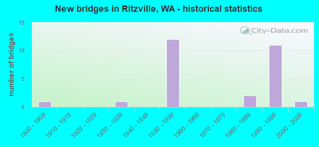
- New bridges - historical statistics
- 11900-1909
- 11930-1939
- 121950-1959
- 21980-1989
- 111990-1999
- 12000-2009


- Bridge Condition - Deck
- 56.3%Good
- 37.5%Satisfactory
- 6.3%Serious

- Bridge Condition - Superstructure
- 12.5%Very good
- 43.8%Good
- 25.0%Satisfactory
- 12.5%Fair
- 6.3%Poor

- Bridge Condition - Substructure
- 12.5%Very good
- 50.0%Good
- 31.3%Satisfactory
- 6.3%Fair

- Bridge Condition - Channel
- 50.0%Very good
- 16.7%Good
- 33.3%Satisfactory
Find on map >> Show street view
Structure Number: 5761A, Location: 1.5 E JCT US 395 (Lat: 47.116417, Lng: -118.365944), Route carried "on" structure: Interstate 90, Year Built: 1958, Status: Open, Structure Length: 5.15m (16.90ft), Average Daily Traffic: 7,350 (year 2019), Truck Traffic: 25%, Average Future Daily Traffic: 8,849 (year 2039), Design Load: HS 20, Features Intersected: SR 261
Minimum Vertical Clearance: 30+ m (98+ ft), Kilometerpoint: 357.194, Lanes on structure: 2, Lanes under structure: 2, Base Highway Network: Yes, Owner: State Highway Agency, Approaching Roadway Width: 12.2m (40.0ft), Skew: 4 degrees, Material/Design: Concrete continuous, Design/Construction: Slab, Number Of Spans In Main Unit: 3, Length of Maximum Span: 20.1m (65.9ft), Curb-To-Curb Width: 9.7m (31.8ft), Out-to-Out Width: 10.6m (34.8ft)
Condition: Deck: Satisfactory, Superstructure: Poor, Substructure: Satisfactory, Operating Rating: 62.6 metric tons, Method Used To Determine Operating Rating: Load Factor (LF), Inventory Rating: 38.1 metric tons, Method Used To Determine Inventory Rating: Load Factor (LF), Structural Evaluation: Meets minimum limits, Deck Geometry: High priority of replacement, Underclear: Better than present minimum criteria, Approach Roadway Alignment: Equal to present desirable criteria, Length Of Structure Improvement: 5.15m (16.90ft), Designated Inspection Frequency: Every 24 months, Inspection Date: July 2020, Bridge Improvement Cost: $1,420,000, Roadway Improvement Cost: $284,000, Total Project Cost: $2,839,000 ( Estimate for 2014), Deck Structure Type: Concrete Cast-file-Place, Wearing Surface/Protective System: Wearing Surface: Bituminous, Membrane: Preformed Fabric
Find on map >> Show street view
Structure Number: 5761B, Location: 1.5 E JCT US 395 (Lat: 47.116750, Lng: -118.365944), Route carried "on" structure: Interstate 90, Year Built: 1952, Status: Open, Structure Length: 5.15m (16.90ft), Average Daily Traffic: 7,350 (year 2019), Truck Traffic: 25%, Average Future Daily Traffic: 8,849 (year 2039), Design Load: HS 15, Features Intersected: SR 261
Minimum Vertical Clearance: 30+ m (98+ ft), Kilometerpoint: 357.194, Lanes on structure: 2, Lanes under structure: 2, Base Highway Network: Yes, Owner: State Highway Agency, Approaching Roadway Width: 12.2m (40.0ft), Skew: 3 degrees, Material/Design: Concrete continuous, Design/Construction: Slab, Number Of Spans In Main Unit: 3, Length of Maximum Span: 20.1m (65.9ft), Curb-To-Curb Width: 9.7m (31.8ft), Out-to-Out Width: 10.6m (34.8ft)
Condition: Deck: Good, Superstructure: Fair, Substructure: Satisfactory, Operating Rating: 40.8 metric tons, Method Used To Determine Operating Rating: Load and Resistance Factor Rating (LRFR) rating reported by rating factor(RF) method using HL-93 loadings, Inventory Rating: 31.4 metric tons, Method Used To Determine Inventory Rating: Load and Resistance Factor Rating (LRFR) rating reported by rating factor(RF) method using HL-93 loadings, Structural Evaluation: Somewhat better than minimum adequacy, Deck Geometry: High priority of replacement, Underclear: Better than present minimum criteria, Approach Roadway Alignment: Equal to present desirable criteria, Length Of Structure Improvement: 5.15m (16.90ft), Designated Inspection Frequency: Every 24 months, Inspection Date: October 2020, Bridge Improvement Cost: $1,420,000, Roadway Improvement Cost: $284,000, Total Project Cost: $2,839,000 ( Estimate for 2014), Deck Structure Type: Concrete Cast-file-Place, Wearing Surface/Protective System: Wearing Surface: Bituminous, Membrane: Preformed Fabric
Find on map >> Show street view
Structure Number: 5761C, Location: 0.9 E JCT SR 261 (Lat: 47.125556, Lng: -118.352194), Route carried "on" structure: County highway , Year Built: 1958, Status: Open, Structure Length: 10.39m (34.09ft), Average Daily Traffic: 272 (year 2002), Truck Traffic: 5%, Average Future Daily Traffic: 364 (year 2036), Design Load: HS 20, Features Intersected: I-90, Facility Carried by Structure: WELLSANDT RD
Minimum Vertical Clearance: 30+ m (98+ ft), Kilometerpoint: 1.593, Lanes on structure: 2, Lanes under structure: 4, Owner: State Highway Agency, Approaching Roadway Width: 9.4m (30.8ft), Material/Design: Concrete continuous, Design/Construction: Box Beam or Girders - Multiple, Number Of Spans In Main Unit: 5, Length of Maximum Span: 25.9m (85.0ft), Curb or Sidewalk Widths: Left: 1.2m (3.9ft), Right: 1.2m (3.9ft), Curb-To-Curb Width: 7.9m (25.9ft), Out-to-Out Width: 10.2m (33.5ft)
Condition: Deck: Good, Superstructure: Satisfactory, Substructure: Good, Operating Rating: 71.7 metric tons, Method Used To Determine Operating Rating: Load Factor (LF), Inventory Rating: 42.6 metric tons, Method Used To Determine Inventory Rating: Load Factor (LF), Structural Evaluation: Equal to present minimum criteria, Deck Geometry: Somewhat better than minimum adequacy, Underclear: High priority of corrective action, Approach Roadway Alignment: Equal to present desirable criteria, Length Of Structure Improvement: 10.39m (34.09ft), Designated Inspection Frequency: Every 48 months, Inspection Date: July 2018, Bridge Improvement Cost: $2,250,000, Roadway Improvement Cost: $450,000, Total Project Cost: $4,501,000 ( Estimate for 2014), Deck Structure Type: Concrete Cast-file-Place, Wearing Surface/Protective System: Wearing Surface: Bituminous, Membrane: Preformed Fabric
Find on map >> Show street view
Structure Number: 5783A, Location: 4.4 E JCT SR 261 (Lat: 47.162414, Lng: -118.300675), Route carried "on" structure: County highway , Year Built: 1958, Status: Open, Structure Length: 10.39m (34.09ft), Average Daily Traffic: 169 (year 2019), Truck Traffic: 5%, Average Future Daily Traffic: 203 (year 2039), Design Load: HS 20, Features Intersected: I-90, Facility Carried by Structure: SCHOESSLER RD
Minimum Vertical Clearance: 30+ m (98+ ft), Kilometerpoint: 0.161, Lanes on structure: 2, Lanes under structure: 4, Owner: State Highway Agency, Approaching Roadway Width: 8.5m (27.9ft), Material/Design: Concrete continuous, Design/Construction: Box Beam or Girders - Multiple, Number Of Spans In Main Unit: 5, Length of Maximum Span: 25.9m (85.0ft), Curb or Sidewalk Widths: Left: 0.5m (1.6ft), Right: 0.5m (1.6ft), Curb-To-Curb Width: 7.9m (25.9ft), Out-to-Out Width: 10.4m (34.1ft)
Condition: Deck: Good, Superstructure: Fair, Substructure: Satisfactory, Operating Rating: 38.6 metric tons, Method Used To Determine Operating Rating: Load and Resistance Factor Rating (LRFR) rating reported by rating factor(RF) method using HL-93 loadings, Inventory Rating: 29.8 metric tons, Method Used To Determine Inventory Rating: Load and Resistance Factor Rating (LRFR) rating reported by rating factor(RF) method using HL-93 loadings, Structural Evaluation: Somewhat better than minimum adequacy, Deck Geometry: Somewhat better than minimum adequacy, Underclear: High priority of corrective action, Approach Roadway Alignment: Equal to present desirable criteria, Length Of Structure Improvement: 10.39m (34.09ft), Designated Inspection Frequency: Every 24 months, Inspection Date: October 2020, Bridge Improvement Cost: $2,046,000, Roadway Improvement Cost: $409,000, Total Project Cost: $4,092,000 ( Estimate for 2014), Deck Structure Type: Concrete Cast-file-Place, Wearing Surface/Protective System: Wearing Surface: Bituminous, Membrane: Preformed Fabric
Find on map >> Show street view
Structure Number: 5789A, Location: 13.6 N JCT SR 21 (Lat: 47.110944, Lng: -118.395472), Route carried "on" structure: Ramp US 395, Year Built: 1958, Status: Open, Structure Length: 9.39m (30.81ft), Average Daily Traffic: 1,360 (year 2016), Truck Traffic: 32%, Average Future Daily Traffic: 1,700 (year 2038), Design Load: HS 20, Features Intersected: I-90
Minimum Vertical Clearance: 30+ m (98+ ft), Kilometerpoint: 0.483, Lanes on structure: 2, Lanes under structure: 4, Owner: State Highway Agency, Approaching Roadway Width: 12.2m (40.0ft), Material/Design: Concrete continuous, Design/Construction: Box Beam or Girders - Multiple, Number Of Spans In Main Unit: 5, Length of Maximum Span: 23.8m (78.1ft), Curb-To-Curb Width: 10.0m (32.8ft), Out-to-Out Width: 10.9m (35.8ft)
Condition: Deck: Serious, Superstructure: Satisfactory, Substructure: Satisfactory, Operating Rating: 69.8 metric tons, Method Used To Determine Operating Rating: Load Factor (LF), Inventory Rating: 41.7 metric tons, Method Used To Determine Inventory Rating: Load Factor (LF), Structural Evaluation: Equal to present minimum criteria, Deck Geometry: Equal to present minimum criteria, Underclear: Meets minimum limits, Approach Roadway Alignment: Equal to present desirable criteria, Length Of Structure Improvement: 9.39m (30.81ft), Designated Inspection Frequency: Every 24 months, Inspection Date: October 2020, Bridge Improvement Cost: $2,587,000, Roadway Improvement Cost: $517,000, Total Project Cost: $5,174,000 ( Estimate for 2014), Deck Structure Type: Concrete Cast-file-Place, Wearing Surface/Protective System: Wearing Surface: Latex Concrete
Find on map >> Show street view
Structure Number: 12782A, Location: 12.9 E JCT SR 21 (Lat: 47.110667, Lng: -118.400722), Route carried "on" structure: Ramp Interstate 90, Year Built: 1985, Status: Open, Structure Length: 5.49m (18.01ft), Average Daily Traffic: 314 (year 2019), Truck Traffic: 23%, Average Future Daily Traffic: 378 (year 2039), Design Load: HS 20+Mod, Features Intersected: BURLINGTON-NORTHERN RR
Minimum Vertical Clearance: 30+ m (98+ ft), Kilometerpoint: 0.692, Lanes on structure: 1, Owner: State Highway Agency, Approaching Roadway Width: 7.9m (25.9ft), Skew: 4 degrees, Material/Design: Prestressed concrete continuous, Design/Construction: Stringer/Multi-beam, Number Of Spans In Main Unit: 3, Length of Maximum Span: 18.3m (60.0ft), Curb-To-Curb Width: 7.9m (25.9ft), Out-to-Out Width: 8.8m (28.9ft)
Condition: Deck: Good, Superstructure: Good, Substructure: Good, Operating Rating: 81.6 metric tons, Method Used To Determine Operating Rating: Load Factor (LF), Inventory Rating: 48.1 metric tons, Method Used To Determine Inventory Rating: Load Factor (LF), Structural Evaluation: Better than present minimum criteria, Deck Geometry: Equal to present desirable criteria, Underclear: Better than present minimum criteria, Approach Roadway Alignment: Equal to present desirable criteria, Length Of Structure Improvement: 5.49m (18.01ft), Designated Inspection Frequency: Every 48 months, Inspection Date: August 2018, Bridge Improvement Cost: $1,008,000, Roadway Improvement Cost: $202,000, Total Project Cost: $2,016,000 ( Estimate for 2014), Deck Structure Type: Concrete Cast-file-Place, Wearing Surface/Protective System: Wearing Surface: Monolithic Concrete, Deck Protection: Epoxy Coated Reinforcing
Find on map >> Show street view
Structure Number: 14489C, Location: 10.9 N JCT SR 21 (Lat: 47.074861, Lng: -118.410667), Route carried "on" structure: County highway , Year Built: 1995, Status: Open, Structure Length: 7.86m (25.79ft), Average Daily Traffic: 18 (year 2009), Truck Traffic: 10%, Average Future Daily Traffic: 21 (year 2036), Design Load: HS 25 or greater, Features Intersected: US 395, Facility Carried by Structure: URQUHART RD
Minimum Vertical Clearance: 30+ m (98+ ft), Kilometerpoint: 0.001, Lanes on structure: 2, Lanes under structure: 4, Owner: State Highway Agency, Approaching Roadway Width: 8.5m (27.9ft), Skew: 3 degrees, Material/Design: Prestressed concrete continuous, Design/Construction: Stringer/Multi-beam, Number Of Spans In Main Unit: 2, Length of Maximum Span: 38.7m (127.0ft), Curb-To-Curb Width: 8.5m (27.9ft), Out-to-Out Width: 9.4m (30.8ft)
Condition: Deck: Good, Superstructure: Very good, Substructure: Good, Operating Rating: 68.0 metric tons, Method Used To Determine Operating Rating: Load Factor (LF), Inventory Rating: 40.8 metric tons, Method Used To Determine Inventory Rating: Load Factor (LF), Structural Evaluation: Better than present minimum criteria, Deck Geometry: Better than present minimum criteria, Underclear: Equal to present minimum criteria, Approach Roadway Alignment: Equal to present desirable criteria, Length Of Structure Improvement: 7.86m (25.79ft), Designated Inspection Frequency: Every 48 months, Inspection Date: October 2018, Bridge Improvement Cost: $1,548,000, Roadway Improvement Cost: $310,000, Total Project Cost: $3,096,000 ( Estimate for 2014), Deck Structure Type: Concrete Cast-file-Place, Wearing Surface/Protective System: Wearing Surface: Monolithic Concrete, Deck Protection: Epoxy Coated Reinforcing
Find on map >> Show street view
Structure Number: 14601A, Location: 13.0 N JCT SR 21 (Lat: 47.107000, Lng: -118.400333), Route carried "on" structure: US 395, Year Built: 1996, Status: Open, Structure Length: 7.83m (25.69ft), Average Daily Traffic: 4,082 (year 2019), Truck Traffic: 27%, Average Future Daily Traffic: 4,914 (year 2039), Design Load: HS 25 or greater, Features Intersected: N-N RAMP
Minimum Vertical Clearance: 30+ m (98+ ft), Kilometerpoint: 153.660, Lanes on structure: 2, Lanes under structure: 1, Base Highway Network: Yes, Owner: State Highway Agency, Approaching Roadway Width: 12.2m (40.0ft), Skew: 4 degrees, Material/Design: Prestressed concrete continuous, Design/Construction: Stringer/Multi-beam, Number Of Spans In Main Unit: 3, Length of Maximum Span: 33.2m (108.9ft), Curb-To-Curb Width: 12.2m (40.0ft), Out-to-Out Width: 13.1m (43.0ft)
Condition: Deck: Good, Superstructure: Good, Substructure: Good, Operating Rating: 75.3 metric tons, Method Used To Determine Operating Rating: Load Factor (LF), Inventory Rating: 45.4 metric tons, Method Used To Determine Inventory Rating: Load Factor (LF), Structural Evaluation: Better than present minimum criteria, Deck Geometry: Better than present minimum criteria, Underclear: Better than present minimum criteria, Approach Roadway Alignment: Equal to present desirable criteria, Length Of Structure Improvement: 7.83m (25.69ft), Designated Inspection Frequency: Every 48 months, Inspection Date: October 2018, Bridge Improvement Cost: $2,159,000, Roadway Improvement Cost: $432,000, Total Project Cost: $4,318,000 ( Estimate for 2014), Deck Structure Type: Concrete Cast-file-Place, Wearing Surface/Protective System: Wearing Surface: Monolithic Concrete, Deck Protection: Epoxy Coated Reinforcing
Find on map >> Show street view
Structure Number: 14601B, Location: 13.0 N JCT SR 21 (Lat: 47.107472, Lng: -118.399861), Route carried "on" structure: US 395, Year Built: 1996, Status: Open, Structure Length: 7.83m (25.69ft), Average Daily Traffic: 4,082 (year 2019), Truck Traffic: 27%, Average Future Daily Traffic: 4,914 (year 2039), Design Load: HS 25 or greater, Features Intersected: N-N RAMP
Minimum Vertical Clearance: 30+ m (98+ ft), Kilometerpoint: 153.708, Lanes on structure: 2, Lanes under structure: 1, Base Highway Network: Yes, Owner: State Highway Agency, Approaching Roadway Width: 11.6m (38.1ft), Skew: 4 degrees, Material/Design: Prestressed concrete continuous, Design/Construction: Stringer/Multi-beam, Number Of Spans In Main Unit: 3, Length of Maximum Span: 33.2m (108.9ft), Curb-To-Curb Width: 11.6m (38.1ft), Out-to-Out Width: 12.1m (39.7ft)
Condition: Deck: Satisfactory, Superstructure: Good, Substructure: Good, Operating Rating: 69.8 metric tons, Method Used To Determine Operating Rating: Load Factor (LF), Inventory Rating: 41.7 metric tons, Method Used To Determine Inventory Rating: Load Factor (LF), Structural Evaluation: Better than present minimum criteria, Deck Geometry: Better than present minimum criteria, Underclear: Better than present minimum criteria, Approach Roadway Alignment: Equal to present desirable criteria, Length Of Structure Improvement: 7.83m (25.69ft), Designated Inspection Frequency: Every 48 months, Inspection Date: October 2018, Bridge Improvement Cost: $2,056,000, Roadway Improvement Cost: $411,000, Total Project Cost: $4,112,000 ( Estimate for 2014), Deck Structure Type: Concrete Cast-file-Place, Wearing Surface/Protective System: Wearing Surface: Monolithic Concrete, Deck Protection: Epoxy Coated Reinforcing
Find on map >> Show street view
Structure Number: 14601D, Location: 13.6 E JCT SR 21 (Lat: 47.111500, Lng: -118.388889), Route carried "on" structure: Interstate 90, Year Built: 1996, Status: Open, Structure Length: 4.24m (13.91ft), Average Daily Traffic: 5,552 (year 2019), Truck Traffic: 22%, Average Future Daily Traffic: 6,684 (year 2039), Design Load: HS 25 or greater, Features Intersected: US 395 SB
Minimum Vertical Clearance: 30+ m (98+ ft), Kilometerpoint: 355.311, Lanes on structure: 2, Lanes under structure: 2, Base Highway Network: Yes, Owner: State Highway Agency, Approaching Roadway Width: 11.6m (38.1ft), Skew: 4 degrees, Material/Design: Prestressed concrete, Design/Construction: Stringer/Multi-beam, Number Of Spans In Main Unit: 1, Length of Maximum Span: 40.8m (133.9ft), Curb-To-Curb Width: 11.6m (38.1ft), Out-to-Out Width: 12.1m (39.7ft)
Condition: Deck: Satisfactory, Superstructure: Good, Substructure: Very good, Operating Rating: 89.8 metric tons, Method Used To Determine Operating Rating: Load Factor (LF), Inventory Rating: 57.1 metric tons, Method Used To Determine Inventory Rating: Load Factor (LF), Structural Evaluation: Better than present minimum criteria, Deck Geometry: Equal to present minimum criteria, Underclear: Somewhat better than minimum adequacy, Approach Roadway Alignment: Equal to present desirable criteria, Length Of Structure Improvement: 4.24m (13.91ft), Designated Inspection Frequency: Every 24 months, Inspection Date: September 2021, Bridge Improvement Cost: $1,112,000, Roadway Improvement Cost: $222,000, Total Project Cost: $2,224,000 ( Estimate for 2014), Deck Structure Type: Concrete Cast-file-Place, Wearing Surface/Protective System: Wearing Surface: Monolithic Concrete, Deck Protection: Epoxy Coated Reinforcing
Find on map >> Show street view
Structure Number: 14601E, Location: 13.6 E JCT SR 21 (Lat: 47.111167, Lng: -118.389417), Route carried "on" structure: Interstate 90, Year Built: 1995, Status: Open, Structure Length: 4.24m (13.91ft), Average Daily Traffic: 5,552 (year 2019), Truck Traffic: 22%, Average Future Daily Traffic: 6,684 (year 2039), Design Load: HS 25 or greater, Features Intersected: US 395 SB
Minimum Vertical Clearance: 30+ m (98+ ft), Kilometerpoint: 355.295, Lanes on structure: 3, Lanes under structure: 2, Base Highway Network: Yes, Owner: State Highway Agency, Approaching Roadway Width: 16.5m (54.1ft), Skew: 4 degrees, Material/Design: Prestressed concrete, Design/Construction: Stringer/Multi-beam, Number Of Spans In Main Unit: 1, Length of Maximum Span: 40.5m (132.9ft), Curb-To-Curb Width: 16.8m (55.1ft), Out-to-Out Width: 18.1m (59.4ft)
Condition: Deck: Satisfactory, Superstructure: Very good, Substructure: Very good, Operating Rating: 89.8 metric tons, Method Used To Determine Operating Rating: Load Factor (LF), Inventory Rating: 54.4 metric tons, Method Used To Determine Inventory Rating: Load Factor (LF), Structural Evaluation: Equal to present desirable criteria, Deck Geometry: Equal to present minimum criteria, Underclear: Meets minimum limits, Approach Roadway Alignment: Equal to present desirable criteria, Length Of Structure Improvement: 4.24m (13.91ft), Designated Inspection Frequency: Every 24 months, Inspection Date: September 2021, Bridge Improvement Cost: $1,557,000, Roadway Improvement Cost: $311,000, Total Project Cost: $3,114,000 ( Estimate for 2014), Deck Structure Type: Concrete Cast-file-Place, Wearing Surface/Protective System: Wearing Surface: Monolithic Concrete, Deck Protection: Epoxy Coated Reinforcing
Find on map >> Show street view
Structure Number: 200062, Location: 13.1 E JCT SR 21 (Lat: 47.111028, Lng: -118.409056), Route carried "on" structure: Interstate 90, Year Built: 1959, Status: Open, Structure Length: 0.67m (2.20ft), Average Daily Traffic: 11,657 (year 2019), Truck Traffic: 22%, Average Future Daily Traffic: 14,035 (year 2039), Features Intersected: PAHA COULEE
Minimum Vertical Clearance: 30+ m (98+ ft), Kilometerpoint: 353.798, Lanes on structure: 4, Base Highway Network: Yes, Owner: State Highway Agency, Approaching Roadway Width: 19.5m (64.0ft), Skew: 10 degrees, Material/Design: Concrete, Design/Construction: Culvert, Number Of Spans In Main Unit: 2, Length of Maximum Span: 3.0m (9.8ft)
Condition: Channel: Very good, Culverts: Good, Operating Rating: 58.0 metric tons, Method Used To Determine Operating Rating: Load Factor (LF), Inventory Rating: 34.5 metric tons, Method Used To Determine Inventory Rating: Load Factor (LF), Structural Evaluation: Better than present minimum criteria, Waterway Adequacy: Equal to present desirable criteria, Approach Roadway Alignment: Equal to present desirable criteria, Length Of Structure Improvement: 0.67m (2.20ft), Designated Inspection Frequency: Every 48 months, Inspection Date: October 2020, Bridge Improvement Cost: $290,000, Roadway Improvement Cost: $58,000, Total Project Cost: $581,000 ( Estimate for 2014)
Find on map >> Show street view
Structure Number: 8168, Location: 00.24 MI N DANEKAS RD (Lat: 47.140325, Lng: -118.365722), Route carried "on" structure: ServiceCounty highway 85782, Year Built: 1900, Status: Open, Structure Length: 0.70m (2.30ft), Average Daily Traffic: 80 (year 2018), Truck Traffic: 5%, Average Future Daily Traffic: 100 (year 2039), Features Intersected: INTERMITTENT STREAM, Facility Carried by Structure: BAUMAN RD.
Minimum Vertical Clearance: 30+ m (98+ ft), Kilometerpoint: 0.001, Lanes on structure: 2, Owner: County Highway Agency, Approaching Roadway Width: 6.1m (20.0ft), Skew: 4 degrees, Material/Design: Concrete, Design/Construction: Slab, Number Of Spans In Main Unit: 2, Length of Maximum Span: 3.0m (9.8ft), Curb-To-Curb Width: 6.5m (21.3ft), Out-to-Out Width: 6.6m (21.7ft)
Condition: Deck: Satisfactory, Superstructure: Satisfactory, Substructure: Satisfactory, Channel: Good, Operating Rating: 21.8 metric tons, Method Used To Determine Operating Rating: Field evaluation and documented engineering judgment, Inventory Rating: 13.6 metric tons, Method Used To Determine Inventory Rating: Field evaluation and documented engineering judgment, Structural Evaluation: Meets minimum limits, Deck Geometry: Somewhat better than minimum adequacy, Waterway Adequacy: Equal to present minimum criteria, Approach Roadway Alignment: Equal to present desirable criteria, Length Of Structure Improvement: 1.01m (3.31ft), Designated Inspection Frequency: Every 24 months, Inspection Date: November 2021, Bridge Improvement Cost: $502,000, Roadway Improvement Cost: $100,000, Total Project Cost: $1,003,000 ( Estimate for 2014), Deck Structure Type: Concrete Cast-file-Place, Wearing Surface/Protective System: Wearing Surface: Bituminous
Find on map >> Show street view
Structure Number: 83748, Location: 00.20 MI W SR 395 (Lat: 47.103356, Lng: -118.412194), Route carried "on" structure: County highway 74512, Year Built: 1995, Status: Open, Structure Length: 0.76m (2.49ft), Average Daily Traffic: 71 (year 2018), Truck Traffic: 10%, Average Future Daily Traffic: 81 (year 2039), Design Load: HS 25 or greater, Features Intersected: DRY WASH, Facility Carried by Structure: HEINEMAN RD
Minimum Vertical Clearance: 30+ m (98+ ft), Kilometerpoint: 0.001, Lanes on structure: 2, Owner: County Highway Agency, Approaching Roadway Width: 6.4m (21.0ft), Material/Design: Prestressed concrete, Design/Construction: Slab, Number Of Spans In Main Unit: 1, Length of Maximum Span: 7.3m (24.0ft), Curb-To-Curb Width: 9.0m (29.5ft), Out-to-Out Width: 9.1m (29.9ft)
Condition: Deck: Good, Superstructure: Good, Substructure: Good, Channel: Very good, Operating Rating: 49.2 metric tons, Method Used To Determine Operating Rating: Load and Resistance Factor Rating (LRFR) rating reported by rating factor(RF) method using HL-93 loadings, Inventory Rating: 31.8 metric tons, Method Used To Determine Inventory Rating: Load and Resistance Factor Rating (LRFR) rating reported by rating factor(RF) method using HL-93 loadings, Structural Evaluation: Better than present minimum criteria, Deck Geometry: Better than present minimum criteria, Waterway Adequacy: Equal to present desirable criteria, Approach Roadway Alignment: Equal to present desirable criteria, Length Of Structure Improvement: 1.07m (3.51ft), Designated Inspection Frequency: Every 24 months, Inspection Date: November 2021, Bridge Improvement Cost: $532,000, Roadway Improvement Cost: $106,000, Total Project Cost: $1,064,000 ( Estimate for 2014), Deck Structure Type: Concrete Precast Panels, Wearing Surface/Protective System: Deck Protection: Internally Sealed
Find on map >> Show street view
Structure Number: 854, Location: 0.01 SE ELM AVE (Lat: 47.130625, Lng: -118.385428), Route carried "on" structure: City street 86821, Year Built: 1930, Year Reconstructed: 1970, Status: Open, Structure Length: 1.34m (4.40ft), Average Daily Traffic: 846 (year 2018), Truck Traffic: 3%, Average Future Daily Traffic: 1,053 (year 2039), Features Intersected: PAHA DRAINAGE DITCH, Facility Carried by Structure: DIVISION STREET
Minimum Vertical Clearance: 30+ m (98+ ft), Kilometerpoint: 0.001, Lanes on structure: 2, Owner: City or Municipal Highway Agency, Approaching Roadway Width: 12.2m (40.0ft), Material/Design: Concrete continuous, Design/Construction: Slab, Number Of Spans In Main Unit: 3, Length of Maximum Span: 4.0m (13.1ft), Curb or Sidewalk Widths: Left: 1.4m (4.6ft), Right: 1.4m (4.6ft), Curb-To-Curb Width: 8.7m (28.5ft), Out-to-Out Width: 11.5m (37.7ft)
Condition: Deck: Satisfactory, Superstructure: Satisfactory, Substructure: Fair, Channel: Satisfactory, Operating Rating: 60.6 metric tons, Method Used To Determine Operating Rating: Load and Resistance Factor Rating (LRFR) rating reported by rating factor(RF) method using HL-93 loadings, Inventory Rating: 46.7 metric tons, Method Used To Determine Inventory Rating: Load and Resistance Factor Rating (LRFR) rating reported by rating factor(RF) method using HL-93 loadings, Structural Evaluation: Somewhat better than minimum adequacy, Deck Geometry: Somewhat better than minimum adequacy, Waterway Adequacy: Equal to present minimum criteria, Approach Roadway Alignment: Equal to present desirable criteria, Length Of Structure Improvement: 1.34m (4.40ft), Designated Inspection Frequency: Every 24 months, Inspection Date: November 2020, Bridge Improvement Cost: $370,000, Roadway Improvement Cost: $74,000, Total Project Cost: $739,000 ( Estimate for 2014), Deck Structure Type: Concrete Cast-file-Place, Wearing Surface/Protective System: Wearing Surface: Bituminous
Find on map >> Show street view
Structure Number: 85772, Location: 0.02 SE CHERRY AVE (Lat: 47.131825, Lng: -118.383322), Route carried "on" structure: City street 1090, Year Built: 1987, Status: Open, Structure Length: 1.28m (4.20ft), Average Daily Traffic: 95 (year 2018), Truck Traffic: 6%, Average Future Daily Traffic: 120 (year 2039), Design Load: HS 20, Features Intersected: PAHA DRAINAGE DITCH, Facility Carried by Structure: CHELAN STREET
Minimum Vertical Clearance: 30+ m (98+ ft), Kilometerpoint: 0.001, Lanes on structure: 2, Owner: City or Municipal Highway Agency, Approaching Roadway Width: 7.3m (24.0ft), Material/Design: Concrete continuous, Design/Construction: Stringer/Multi-beam, Number Of Spans In Main Unit: 1, Length of Maximum Span: 12.5m (41.0ft), Curb-To-Curb Width: 7.3m (24.0ft), Out-to-Out Width: 7.8m (25.6ft)
Condition: Deck: Good, Superstructure: Good, Substructure: Good, Channel: Satisfactory, Operating Rating: 59.9 metric tons, Method Used To Determine Operating Rating: Load and Resistance Factor Rating (LRFR) rating reported by rating factor(RF) method using HL-93 loadings, Inventory Rating: 43.4 metric tons, Method Used To Determine Inventory Rating: Load and Resistance Factor Rating (LRFR) rating reported by rating factor(RF) method using HL-93 loadings, Structural Evaluation: Better than present minimum criteria, Deck Geometry: Equal to present minimum criteria, Waterway Adequacy: Equal to present desirable criteria, Approach Roadway Alignment: Equal to present desirable criteria, Length Of Structure Improvement: 1.58m (5.18ft), Designated Inspection Frequency: Every 24 months, Inspection Date: November 2020, Bridge Improvement Cost: $790,000, Roadway Improvement Cost: $158,000, Total Project Cost: $1,581,000 ( Estimate for 2014), Deck Structure Type: Other, Wearing Surface/Protective System: Wearing Surface: Bituminous
Find on map >> Show street view
Structure Number: 86548, Location: 02.27 MI N ROSENOFF (Lat: 47.165717, Lng: -118.451878), Route carried "on" structure: County highway 75564, Year Built: 2000, Status: Open, Structure Length: 1.22m (4.00ft), Average Daily Traffic: 15 (year 2018), Average Future Daily Traffic: 19 (year 2039), Design Load: HS 25 or greater, Features Intersected: DRY WASH, Facility Carried by Structure: BAUER RD
Minimum Vertical Clearance: 30+ m (98+ ft), Kilometerpoint: 0.001, Lanes on structure: 2, Owner: County Highway Agency, Approaching Roadway Width: 8.5m (27.9ft), Skew: 4 degrees, Material/Design: Concrete continuous, Design/Construction: Stringer/Multi-beam, Number Of Spans In Main Unit: 1, Length of Maximum Span: 11.3m (37.1ft), Curb-To-Curb Width: 8.5m (27.9ft), Out-to-Out Width: 8.7m (28.5ft)
Condition: Deck: Good, Superstructure: Good, Substructure: Good, Channel: Very good, Operating Rating: 48.3 metric tons, Method Used To Determine Operating Rating: Load and Resistance Factor Rating (LRFR) rating reported by rating factor(RF) method using HL-93 loadings, Inventory Rating: 34.3 metric tons, Method Used To Determine Inventory Rating: Load and Resistance Factor Rating (LRFR) rating reported by rating factor(RF) method using HL-93 loadings, Structural Evaluation: Better than present minimum criteria, Deck Geometry: Better than present minimum criteria, Waterway Adequacy: Equal to present desirable criteria, Approach Roadway Alignment: Equal to present desirable criteria, Length Of Structure Improvement: 1.52m (4.99ft), Designated Inspection Frequency: Every 24 months, Inspection Date: November 2020, Bridge Improvement Cost: $760,000, Roadway Improvement Cost: $152,000, Total Project Cost: $1,520,000 ( Estimate for 2014), Deck Structure Type: Other, Wearing Surface/Protective System: Deck Protection: Epoxy Coated Reinforcing
Find on map >> Show street view
Structure Number: 5761A, Location: 26.9 N JCT SR 26 (Lat: 47.116417, Lng: -118.365944), Route carried "under" structure: State highway 261, Year Built: 1958, Structure Length: 0. m, Average Daily Traffic: 5,942 (year 2019), Truck Traffic: 37%, Features Intersected: SR 261, Facility Carried by Structure: I-90
Minimum Vertical Clearance: 5.23m (17.16ft), Kilometerpoint: 101.067, Lanes on structure: 2, Lanes under structure: 2, Material/Design: Concrete continuous, Design/Construction: Slab, Length of Maximum Span: 20.1m (65.9ft)
Find on map >> Show street view
Structure Number: 5761B, Location: 26.9 N JCT SR 26 (Lat: 47.116750, Lng: -118.365944), Route carried "under" structure: State highway 261, Year Built: 1952, Structure Length: 0. m, Average Daily Traffic: 5,942 (year 2019), Truck Traffic: 37%, Features Intersected: SR 261, Facility Carried by Structure: I-90
Minimum Vertical Clearance: 5.56m (18.24ft), Kilometerpoint: 101.115, Lanes on structure: 2, Lanes under structure: 2, Material/Design: Concrete continuous, Design/Construction: Slab, Length of Maximum Span: 20.1m (65.9ft)
Find on map >> Show street view
Structure Number: 5761C, Location: 0.9 E JCT SR 261 (Lat: 47.125556, Lng: -118.352194), Route carried "under" structure: Interstate 90, Year Built: 1958, Structure Length: 0. m, Average Daily Traffic: 19,492 (year 2019), Truck Traffic: 25%, Features Intersected: I-90, Facility Carried by Structure: WELLSANDT RD
Minimum Vertical Clearance: 5.31m (17.42ft), Kilometerpoint: 358.642, Lanes on structure: 2, Lanes under structure: 4, Material/Design: Concrete continuous, Design/Construction: Box Beam or Girders - Multiple, Length of Maximum Span: 25.9m (85.0ft)
Find on map >> Show street view
Structure Number: 5783A, Location: 4.4 E JCT SR 261 (Lat: 47.162414, Lng: -118.300675), Route carried "under" structure: Interstate 90, Year Built: 1958, Structure Length: 0. m, Average Daily Traffic: 19,238 (year 2019), Truck Traffic: 25%, Features Intersected: I-90, Facility Carried by Structure: SCHOESSLER RD
Minimum Vertical Clearance: 4.52m (14.83ft), Kilometerpoint: 364.388, Lanes on structure: 2, Lanes under structure: 4, Material/Design: Concrete continuous, Design/Construction: Box Beam or Girders - Multiple, Length of Maximum Span: 25.9m (85.0ft)
Find on map >> Show street view
Structure Number: 5789A, Location: 13.4 E JCT SR 21 (Lat: 47.110944, Lng: -118.395472), Route carried "under" structure: Interstate 90, Year Built: 1958, Structure Length: 0. m, Average Daily Traffic: 11,103 (year 2019), Truck Traffic: 22%, Features Intersected: I-90, Facility Carried by Structure: US 395 RAMP
Minimum Vertical Clearance: 5.51m (18.08ft), Kilometerpoint: 354.844, Lanes on structure: 2, Lanes under structure: 4, Material/Design: Concrete continuous, Design/Construction: Box Beam or Girders - Multiple, Length of Maximum Span: 23.8m (78.1ft)
Find on map >> Show street view
Structure Number: 6031A, Location: 13.4 E JCT SR 21 (Lat: 47.111278, Lng: -118.399417), Route carried "under" structure: Interstate 90, Year Built: 1959, Structure Length: 0. m, Average Daily Traffic: 11,103 (year 2019), Truck Traffic: 22%, Features Intersected: I-90, Facility Carried by Structure: NP RY
Minimum Vertical Clearance: 4.80m (15.75ft), Kilometerpoint: 354.506, Lanes under structure: 5, Material/Design: Steel, Design/Construction: Girder and Floorbeam System, Length of Maximum Span: 32.0m (105.0ft)
Find on map >> Show street view
Structure Number: 14489C, Location: 10.9 N JCT SR 21 (Lat: 47.074861, Lng: -118.410667), Route carried "under" structure: US 395, Year Built: 1995, Structure Length: 0. m, Average Daily Traffic: 8,725 (year 2019), Truck Traffic: 27%, Features Intersected: US 395, Facility Carried by Structure: URQUHART RD
Minimum Vertical Clearance: 5.64m (18.50ft), Kilometerpoint: 149.766, Lanes on structure: 2, Lanes under structure: 4, Material/Design: Prestressed concrete continuous, Design/Construction: Stringer/Multi-beam, Length of Maximum Span: 38.7m (127.0ft)
Find on map >> Show street view
Structure Number: 14601A, Location: 13.0 N JCT SR 21 (Lat: 47.107000, Lng: -118.400333), Route carried "under" structure: Ramp US 395, Year Built: 1996, Structure Length: 0. m, Average Daily Traffic: 403 (year 2019), Truck Traffic: 25%, Features Intersected: N-N RAMP
Minimum Vertical Clearance: 5.92m (19.42ft), Kilometerpoint: 0.982, Lanes on structure: 2, Lanes under structure: 1, Material/Design: Prestressed concrete continuous, Design/Construction: Stringer/Multi-beam, Length of Maximum Span: 33.2m (108.9ft)
Find on map >> Show street view
Structure Number: 14601B, Location: 13.0 N JCT SR 21 (Lat: 47.107472, Lng: -118.399861), Route carried "under" structure: Ramp US 395, Year Built: 1996, Structure Length: 0. m, Average Daily Traffic: 403 (year 2019), Truck Traffic: 25%, Features Intersected: N-N RAMP
Minimum Vertical Clearance: 5.69m (18.67ft), Kilometerpoint: 1.046, Lanes on structure: 2, Lanes under structure: 1, Material/Design: Prestressed concrete continuous, Design/Construction: Stringer/Multi-beam, Length of Maximum Span: 33.2m (108.9ft)
Find on map >> Show street view
Structure Number: 14601D, Location: 13.4 E JCT SR 21 (Lat: 47.111500, Lng: -118.388889), Route carried "under" structure: Ramp Interstate 90, Year Built: 1996, Structure Length: 0. m, Average Daily Traffic: 4,082 (year 2019), Truck Traffic: 27%, Features Intersected: US 395 SB
Minimum Vertical Clearance: 6.12m (20.08ft), Kilometerpoint: 154.706, Lanes on structure: 2, Lanes under structure: 2, Material/Design: Prestressed concrete, Design/Construction: Stringer/Multi-beam, Length of Maximum Span: 40.8m (133.9ft)
Find on map >> Show street view
Structure Number: 14601E, Location: 13.4 E JCT SR 21 (Lat: 47.111167, Lng: -118.389417), Route carried "under" structure: Ramp US 90, Year Built: 1995, Structure Length: 0. m, Average Daily Traffic: 4,082 (year 2019), Truck Traffic: 27%, Features Intersected: US 395 SB
Minimum Vertical Clearance: 5.41m (17.75ft), Kilometerpoint: 154.658, Lanes on structure: 3, Lanes under structure: 2, Material/Design: Prestressed concrete, Design/Construction: Stringer/Multi-beam, Length of Maximum Span: 40.5m (132.9ft)