Bridge Statistics for Riverdale, California (CA)
Condition, Traffic, Stress, Structural Evaluation, Project Costs
- National Bridge Inventory (NBI) Statistics
- 22Number of bridges
- 184ft / 55.6mTotal length
- $595,000Total costs
- 67,253Total average daily traffic
- 8,916Total average daily truck traffic
- National Bridge Inventory (NBI) Registered Bridges for Riverdale
- No street view available for this location
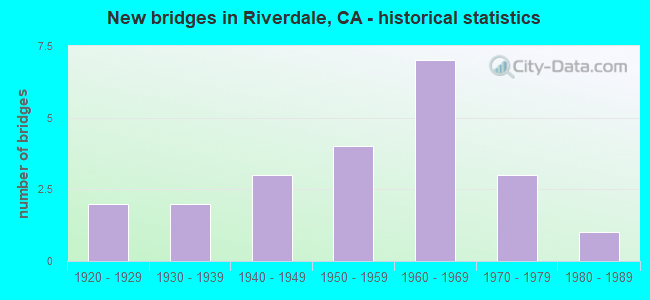
- New bridges - historical statistics
- 21920-1929
- 21930-1939
- 31940-1949
- 41950-1959
- 71960-1969
- 31970-1979
- 11980-1989

- Reconstructed bridges - Historical Statistics
- 21950-1959
- 11960-1969
- 31970-1979
- 21980-1989
- 11990-1999


- Bridge Condition - Deck
- 66.7%Good
- 5.6%Satisfactory
- 27.8%Fair

- Bridge Condition - Superstructure
- 72.2%Good
- 27.8%Fair

- Bridge Condition - Substructure
- 38.9%Good
- 5.6%Satisfactory
- 44.4%Fair
- 5.6%Poor
- 5.6%Critical

- Bridge Condition - Channel
- 77.8%Good
- 22.2%Satisfactory
Find on map >> Show street view
Structure Number: 42 0036, Location: 06-FRE-041-R3.94 (Lat: 36.458600, Lng: -119.795969), Route carried "on" structure: State highway 41, Year Built: 1964, Status: Open, Structure Length: 3.02m (9.91ft), Average Daily Traffic: 19,500 (year 2009), Truck Traffic: 15%, Average Future Daily Traffic: 18,988 (year 2042), Design Load: HS 20, Features Intersected: MURPHY SLOUGH
Minimum Vertical Clearance: 30+ m (98+ ft), Kilometerpoint: 3.940, Lanes on structure: 2, Base Highway Network: Yes (, Subroute: 1), Owner: State Highway Agency, Approaching Roadway Width: 12.2m (40.0ft), Skew: 2 degrees, Material/Design: Concrete continuous, Design/Construction: Slab, Number Of Spans In Main Unit: 4, Length of Maximum Span: 8.5m (27.9ft), Curb-To-Curb Width: 12.2m (40.0ft), Out-to-Out Width: 13.0m (42.7ft)
Condition: Deck: Good, Superstructure: Good, Substructure: Fair, Channel: Satisfactory, Operating Rating: 68.0 metric tons, Method Used To Determine Operating Rating: Load Factor (LF), Inventory Rating: 40.8 metric tons, Method Used To Determine Inventory Rating: Load Factor (LF), Structural Evaluation: Somewhat better than minimum adequacy, Deck Geometry: Somewhat better than minimum adequacy, Waterway Adequacy: Equal to present desirable criteria, Approach Roadway Alignment: Equal to present desirable criteria, Designated Inspection Frequency: Every 24 months, Inspection Date: October 2020, Deck Structure Type: Concrete Cast-file-Place, Wearing Surface/Protective System: Wearing Surface: Bituminous
Find on map >> Show street view
Structure Number: 42C0082, Location: 1.9 MI N OF MT WHITNEY AV (Lat: 36.458678, Lng: -119.795503), Route carried "on" structure: County highway , Year Built: 1964, Status: Open, Structure Length: 3.02m (9.91ft), Average Daily Traffic: 450 (year 2009), Truck Traffic: 2%, Average Future Daily Traffic: 563 (year 2040), Design Load: HS 20+Mod, Features Intersected: MURPHY SLOUGH, Facility Carried by Structure: S CAMDEN AVE
Minimum Vertical Clearance: 30+ m (98+ ft), Kilometerpoint: 0.000, Lanes on structure: 2, Owner: County Highway Agency, Approaching Roadway Width: 8.2m (26.9ft), Skew: 2 degrees, Material/Design: Concrete continuous, Design/Construction: Slab, Number Of Spans In Main Unit: 4, Length of Maximum Span: 8.5m (27.9ft), Curb or Sidewalk Widths: Left: 0.6m (2.0ft), Right: 0.6m (2.0ft), Curb-To-Curb Width: 8.5m (27.9ft), Out-to-Out Width: 10.4m (34.1ft)
Condition: Deck: Good, Superstructure: Good, Substructure: Fair, Channel: Good, Operating Rating: 61.9 metric tons, Method Used To Determine Operating Rating: Load Factor (LF), Inventory Rating: 37.3 metric tons, Method Used To Determine Inventory Rating: Load Factor (LF), Structural Evaluation: Somewhat better than minimum adequacy, Deck Geometry: Somewhat better than minimum adequacy, Waterway Adequacy: Equal to present desirable criteria, Approach Roadway Alignment: Equal to present desirable criteria, Designated Inspection Frequency: Every 24 months, Inspection Date: January 2022, Deck Structure Type: Concrete Cast-file-Place
Find on map >> Show street view
Structure Number: 42C0089, Location: 2 MI SOUTH OF ELKHORN AVE (Lat: 36.460322, Lng: -119.798536), Route carried "on" structure: County highway , Year Built: 1922, Year Reconstructed: 1962, Status: Open, Structure Length: 2.62m (8.60ft), Average Daily Traffic: 340 (year 2012), Truck Traffic: 8%, Average Future Daily Traffic: 408 (year 2040), Features Intersected: MURPHY SLOUGH, Facility Carried by Structure: S ELM AVE
Minimum Vertical Clearance: 30+ m (98+ ft), Kilometerpoint: 0.000, Lanes on structure: 2, Owner: County Highway Agency, Approaching Roadway Width: 6.4m (21.0ft), Material/Design: Concrete continuous, Design/Construction: Slab, Number Of Spans In Main Unit: 5, Length of Maximum Span: 5.2m (17.1ft), Curb-To-Curb Width: 9.8m (32.2ft), Out-to-Out Width: 10.0m (32.8ft)
Condition: Deck: Good, Superstructure: Good, Substructure: Fair, Channel: Good, Operating Rating: 27.2 metric tons, Method Used To Determine Operating Rating: Field evaluation and documented engineering judgment, Inventory Rating: 16.2 metric tons, Method Used To Determine Inventory Rating: Field evaluation and documented engineering judgment, Structural Evaluation: Somewhat better than minimum adequacy, Deck Geometry: Better than present minimum criteria, Waterway Adequacy: Equal to present desirable criteria, Approach Roadway Alignment: Equal to present desirable criteria, Designated Inspection Frequency: Every 24 months, Inspection Date: Febuary 2022, Deck Structure Type: Concrete Cast-file-Place, Wearing Surface/Protective System: Wearing Surface: Bituminous
Find on map >> Show street view
Structure Number: 42C0163, Location: 0.7 MI N MT WHITNEY AVE (Lat: 36.441814, Lng: -119.851147), Route carried "on" structure: County highway , Year Built: 1975, Status: Open, Structure Length: 1.31m (4.30ft), Average Daily Traffic: 1,400 (year 2009), Truck Traffic: 16%, Average Future Daily Traffic: 3,336 (year 2042), Design Load: HS 20+Mod, Features Intersected: MURPHY SLOUGH, Facility Carried by Structure: S MARKS AVE
Minimum Vertical Clearance: 30+ m (98+ ft), Kilometerpoint: 0.000, Lanes on structure: 2, Owner: County Highway Agency, Approaching Roadway Width: 7.6m (24.9ft), Material/Design: Concrete continuous, Design/Construction: Slab, Number Of Spans In Main Unit: 2, Length of Maximum Span: 6.1m (20.0ft), Curb-To-Curb Width: 9.8m (32.2ft), Out-to-Out Width: 9.9m (32.5ft)
Condition: Deck: Good, Superstructure: Good, Substructure: Poor, Channel: Good, Operating Rating: 91.7 metric tons, Method Used To Determine Operating Rating: Load Factor (LF), Inventory Rating: 55.1 metric tons, Method Used To Determine Inventory Rating: Load Factor (LF), Structural Evaluation: Meets minimum limits, Deck Geometry: Somewhat better than minimum adequacy, Waterway Adequacy: Equal to present desirable criteria, Approach Roadway Alignment: Equal to present desirable criteria, Length Of Structure Improvement: 1.31m (4.30ft), Designated Inspection Frequency: Every 24 months, Inspection Date: Febuary 2022, Bridge Improvement Cost: $130,000, Roadway Improvement Cost: $26,000, Total Project Cost: $218,000 ( Estimate for 2018), Deck Structure Type: Concrete Cast-file-Place, Wearing Surface/Protective System: Wearing Surface: Bituminous
Find on map >> Show street view
Structure Number: 42C0234, Location: 0.06 MI S OF RIVERDALE AV (Lat: 36.437431, Lng: -119.825281), Route carried "on" structure: County highway , Year Built: 1940, Year Reconstructed: 1979, Status: Open, Structure Length: 0.77m (2.53ft), Average Daily Traffic: 500 (year 2007), Truck Traffic: 10%, Average Future Daily Traffic: 651 (year 2042), Design Load: HS 20+Mod, Features Intersected: RIVERDALE DITCH, Facility Carried by Structure: S FRUIT AVE
Minimum Vertical Clearance: 30+ m (98+ ft), Kilometerpoint: 0.000, Lanes on structure: 2, Owner: County Highway Agency, Approaching Roadway Width: 6.1m (20.0ft), Material/Design: Concrete, Design/Construction: Slab, Number Of Spans In Main Unit: 1, Length of Maximum Span: 7.0m (23.0ft), Curb-To-Curb Width: 8.5m (27.9ft), Out-to-Out Width: 8.7m (28.5ft)
Condition: Deck: Fair, Superstructure: Fair, Substructure: Good, Channel: Good, Operating Rating: 99.8 metric tons, Method Used To Determine Operating Rating: Load Factor (LF), Inventory Rating: 67.7 metric tons, Method Used To Determine Inventory Rating: Load Factor (LF), Structural Evaluation: Somewhat better than minimum adequacy, Deck Geometry: Somewhat better than minimum adequacy, Waterway Adequacy: Equal to present desirable criteria, Approach Roadway Alignment: Equal to present desirable criteria, Designated Inspection Frequency: Every 24 months, Inspection Date: Febuary 2022, Deck Structure Type: Concrete Cast-file-Place
Find on map >> Show street view
Structure Number: 42C0292, Location: 1.25 MI W OF S MARKS AVE (Lat: 36.445339, Lng: -119.873942), Route carried "on" structure: County highway , Year Built: 1981, Status: Open, Structure Length: 1.13m (3.71ft), Average Daily Traffic: 600 (year 2012), Truck Traffic: 1%, Average Future Daily Traffic: 924 (year 2040), Features Intersected: MURPHY SLOUGH, Facility Carried by Structure: W HARLAN AVE
Minimum Vertical Clearance: 30+ m (98+ ft), Kilometerpoint: 0.000, Lanes on structure: 2, Owner: County Highway Agency, Approaching Roadway Width: 7.0m (23.0ft), Skew: 5 degrees, Material/Design: Concrete continuous, Design/Construction: Culvert, Number Of Spans In Main Unit: 2, Length of Maximum Span: 5.5m (18.0ft), Curb-To-Curb Width: 9.3m (30.5ft), Out-to-Out Width: 9.9m (32.5ft)
Condition: Channel: Good, Culverts: Satisfactory, Operating Rating: 54.1 metric tons, Method Used To Determine Operating Rating: Field evaluation and documented engineering judgment, Inventory Rating: 32.4 metric tons, Method Used To Determine Inventory Rating: Field evaluation and documented engineering judgment, Structural Evaluation: Equal to present minimum criteria, Deck Geometry: Equal to present minimum criteria, Waterway Adequacy: Equal to present desirable criteria, Approach Roadway Alignment: Equal to present desirable criteria, Designated Inspection Frequency: Every 48 months, Inspection Date: Febuary 2022, Deck Structure Type: Concrete Cast-file-Place, Wearing Surface/Protective System: Wearing Surface: Bituminous
Find on map >> Show street view
Structure Number: 42C0294, Location: 0.7 MI N OF MT WHITNEY AV (Lat: 36.441039, Lng: -119.825322), Route carried "on" structure: County highway , Year Built: 1925, Year Reconstructed: 1981, Status: Open, Structure Length: 1.10m (3.61ft), Average Daily Traffic: 500 (year 2007), Truck Traffic: 2%, Average Future Daily Traffic: 321 (year 2040), Features Intersected: MURPHY SLOUGH, Facility Carried by Structure: S FRUIT AVE
Minimum Vertical Clearance: 30+ m (98+ ft), Kilometerpoint: 0.000, Lanes on structure: 2, Owner: County Highway Agency, Approaching Roadway Width: 6.1m (20.0ft), Material/Design: Wood or Timber, Design/Construction: Stringer/Multi-beam, Number Of Spans In Main Unit: 2, Length of Maximum Span: 5.2m (17.1ft), Curb-To-Curb Width: 7.1m (23.3ft), Out-to-Out Width: 7.3m (24.0ft)
Condition: Deck: Fair, Superstructure: Good, Substructure: Good, Channel: Good, Operating Rating: 43.4 metric tons, Method Used To Determine Operating Rating: Allowable Stress (AS), Inventory Rating: 32.1 metric tons, Method Used To Determine Inventory Rating: Allowable Stress (AS), Structural Evaluation: Better than present minimum criteria, Deck Geometry: Meets minimum limits, Waterway Adequacy: Equal to present desirable criteria, Approach Roadway Alignment: Equal to present desirable criteria, Designated Inspection Frequency: Every 24 months, Inspection Date: January 2022, Deck Structure Type: Concrete Cast-file-Place
Find on map >> Show street view
Structure Number: 42C0306, Location: 2 MI W OF MARKS AVE (Lat: 36.474436, Lng: -119.887319), Route carried "on" structure: County highway , Year Built: 1948, Year Reconstructed: 1990, Status: Open, Structure Length: 0.76m (2.49ft), Average Daily Traffic: 400 (year 1999), Truck Traffic: 10%, Average Future Daily Traffic: 863 (year 2038), Design Load: HS 20+Mod, Features Intersected: LIBERTY MILLRACE CANAL, Facility Carried by Structure: W DAVIS AVE
Minimum Vertical Clearance: 30+ m (98+ ft), Kilometerpoint: 0.000, Lanes on structure: 2, Owner: County Highway Agency, Approaching Roadway Width: 7.6m (24.9ft), Material/Design: Concrete, Design/Construction: Slab, Number Of Spans In Main Unit: 1, Length of Maximum Span: 7.0m (23.0ft), Curb-To-Curb Width: 7.9m (25.9ft), Out-to-Out Width: 8.4m (27.6ft)
Condition: Deck: Good, Superstructure: Good, Substructure: Good, Channel: Good, Operating Rating: 45.0 metric tons, Method Used To Determine Operating Rating: Load and Resistance Factor Rating (LRFR) rating reported by rating factor(RF) method using HL-93 loadings, Inventory Rating: 34.7 metric tons, Method Used To Determine Inventory Rating: Load and Resistance Factor Rating (LRFR) rating reported by rating factor(RF) method using HL-93 loadings, Structural Evaluation: Better than present minimum criteria, Deck Geometry: Somewhat better than minimum adequacy, Waterway Adequacy: Equal to present desirable criteria, Approach Roadway Alignment: Equal to present desirable criteria, Designated Inspection Frequency: Every 48 months, Inspection Date: Febuary 2020, Deck Structure Type: Concrete Cast-file-Place
Find on map >> Show street view
Structure Number: 42C0366, Location: 1.2 MI S/O DAVIS AVE (Lat: 36.457411, Lng: -119.896183), Route carried "on" structure: County highway , Year Built: 1950, Status: Open, Structure Length: 2.10m (6.89ft), Average Daily Traffic: 400 (year 2008), Truck Traffic: 5%, Average Future Daily Traffic: 512 (year 2042), Features Intersected: MURPHY SLOUGH, Facility Carried by Structure: S POLK AVE
Minimum Vertical Clearance: 30+ m (98+ ft), Kilometerpoint: 0.000, Lanes on structure: 2, Owner: County Highway Agency, Approaching Roadway Width: 5.5m (18.0ft), Material/Design: Concrete continuous, Design/Construction: Slab, Number Of Spans In Main Unit: 3, Length of Maximum Span: 6.7m (22.0ft), Curb or Sidewalk Widths: Left: 0.2m (0.7ft), Right: 0.2m (0.7ft), Curb-To-Curb Width: 8.1m (26.6ft), Out-to-Out Width: 8.9m (29.2ft)
Condition: Deck: Good, Superstructure: Good, Substructure: Fair, Channel: Good, Operating Rating: 44.7 metric tons, Method Used To Determine Operating Rating: Load Factor (LF), Inventory Rating: 26.9 metric tons, Method Used To Determine Inventory Rating: Load Factor (LF), Structural Evaluation: Somewhat better than minimum adequacy, Deck Geometry: Somewhat better than minimum adequacy, Waterway Adequacy: Equal to present desirable criteria, Approach Roadway Alignment: Equal to present desirable criteria, Designated Inspection Frequency: Every 24 months, Inspection Date: January 2022, Deck Structure Type: Concrete Cast-file-Place, Wearing Surface/Protective System: Wearing Surface: Bituminous
Find on map >> Show street view
Structure Number: 42C0377, Location: 0.1 MI S OF MT WHITNEY AV (Lat: 36.428931, Lng: -119.855525), Route carried "on" structure: County highway , Year Built: 1950, Status: Open, Structure Length: 0.76m (2.49ft), Average Daily Traffic: 1,200 (year 2010), Truck Traffic: 5%, Average Future Daily Traffic: 984 (year 2042), Features Intersected: BURREL DITCH, Facility Carried by Structure: S FELAND AVE
Minimum Vertical Clearance: 30+ m (98+ ft), Kilometerpoint: 0.000, Lanes on structure: 2, Owner: County Highway Agency, Approaching Roadway Width: 7.0m (23.0ft), Skew: 4 degrees, Material/Design: Concrete continuous, Design/Construction: Slab, Number Of Spans In Main Unit: 2, Length of Maximum Span: 3.7m (12.1ft), Curb or Sidewalk Widths: Left: 0.2m (0.7ft), Right: 0.2m (0.7ft), Curb-To-Curb Width: 8.5m (27.9ft), Out-to-Out Width: 9.3m (30.5ft)
Condition: Deck: Fair, Superstructure: Fair, Substructure: Fair, Channel: Good, Operating Rating: 40.5 metric tons, Method Used To Determine Operating Rating: Field evaluation and documented engineering judgment, Inventory Rating: 24.3 metric tons, Method Used To Determine Inventory Rating: Field evaluation and documented engineering judgment, Structural Evaluation: Somewhat better than minimum adequacy, Deck Geometry: Somewhat better than minimum adequacy, Waterway Adequacy: Better than present minimum criteria, Approach Roadway Alignment: Equal to present desirable criteria, Designated Inspection Frequency: Every 24 months, Inspection Date: Febuary 2022, Deck Structure Type: Concrete Cast-file-Place, Wearing Surface/Protective System: Wearing Surface: Bituminous
Find on map >> Show street view
Structure Number: 42C0378, Location: 0.02 MI S OF RIVERDALE AV (Lat: 36.437892, Lng: -119.816314), Route carried "on" structure: County highway , Year Built: 1940, Year Reconstructed: 1960, Status: Open, Structure Length: 1.34m (4.40ft), Average Daily Traffic: 200 (year 2010), Truck Traffic: 2%, Average Future Daily Traffic: 161 (year 2042), Features Intersected: RIVERDALE DITCH, Facility Carried by Structure: S WALNUT AVE
Minimum Vertical Clearance: 30+ m (98+ ft), Kilometerpoint: 0.000, Lanes on structure: 2, Owner: County Highway Agency, Approaching Roadway Width: 5.5m (18.0ft), Skew: 1 degrees, Material/Design: Wood or Timber, Design/Construction: Stringer/Multi-beam, Number Of Spans In Main Unit: 4, Length of Maximum Span: 3.4m (11.2ft), Curb-To-Curb Width: 7.1m (23.3ft), Out-to-Out Width: 7.3m (24.0ft)
Condition: Deck: Good, Superstructure: Good, Substructure: Critical, Channel: Good, Operating Rating: 35.3 metric tons, Method Used To Determine Operating Rating: Allowable Stress (AS), Inventory Rating: 25.9 metric tons, Method Used To Determine Inventory Rating: Allowable Stress (AS), Structural Evaluation: High priority of replacement, Deck Geometry: Meets minimum limits, Waterway Adequacy: Better than present minimum criteria, Approach Roadway Alignment: Equal to present desirable criteria, Length Of Structure Improvement: 1.34m (4.40ft), Designated Inspection Frequency: Every 24 months, Inspection Date: January 2022, Bridge Improvement Cost: $224,000, Roadway Improvement Cost: $44,000, Total Project Cost: $377,000 ( Estimate for 2017), Deck Structure Type: Corrugated Steel, Wearing Surface/Protective System: Wearing Surface: Bituminous
Find on map >> Show street view
Structure Number: 42C0527, Location: 0.02 MI E OF WALNUT AVE (Lat: 36.438322, Lng: -119.815831), Route carried "on" structure: County highway , Year Built: 1935, Year Reconstructed: 1975, Status: Open, Structure Length: 1.34m (4.40ft), Average Daily Traffic: 900 (year 2010), Truck Traffic: 5%, Average Future Daily Traffic: 1,287 (year 2042), Design Load: HS 20, Features Intersected: RIVERDALE DITCH, Facility Carried by Structure: W RIVERDALE AVE
Minimum Vertical Clearance: 30+ m (98+ ft), Kilometerpoint: 0.000, Lanes on structure: 2, Owner: County Highway Agency, Approaching Roadway Width: 5.2m (17.1ft), Skew: 2 degrees, Material/Design: Wood or Timber, Design/Construction: Stringer/Multi-beam, Number Of Spans In Main Unit: 4, Length of Maximum Span: 3.2m (10.5ft), Curb-To-Curb Width: 7.3m (24.0ft), Out-to-Out Width: 7.6m (24.9ft)
Condition: Deck: Good, Superstructure: Fair, Substructure: Fair, Channel: Good, Operating Rating: 33.0 metric tons, Method Used To Determine Operating Rating: Allowable Stress (AS), Inventory Rating: 24.3 metric tons, Method Used To Determine Inventory Rating: Allowable Stress (AS), Structural Evaluation: Somewhat better than minimum adequacy, Deck Geometry: Meets minimum limits, Waterway Adequacy: Equal to present desirable criteria, Approach Roadway Alignment: Equal to present desirable criteria, Designated Inspection Frequency: Every 24 months, Inspection Date: January 2022, Deck Structure Type: Corrugated Steel, Wearing Surface/Protective System: Wearing Surface: Bituminous
Find on map >> Show street view
Structure Number: 45 0019L, Location: 06-KIN-041-R47.16 (Lat: 36.385881, Lng: -119.809664), Route carried "on" structure: State highway 41, Year Built: 1976, Status: Open, Structure Length: 7.80m (25.59ft), Average Daily Traffic: 8,800 (year 2009), Truck Traffic: 14%, Average Future Daily Traffic: 12,451 (year 2040), Design Load: HS 20+Mod, Features Intersected: NORTH FORK KINGS RIVER
Minimum Vertical Clearance: 30+ m (98+ ft), Kilometerpoint: 47.160, Lanes on structure: 2, Base Highway Network: Yes (, Subroute: 1), Owner: State Highway Agency, Approaching Roadway Width: 11.3m (37.1ft), Skew: 1 degrees, Material/Design: Concrete continuous, Design/Construction: Slab, Number Of Spans In Main Unit: 8, Length of Maximum Span: 10.4m (34.1ft), Curb-To-Curb Width: 11.7m (38.4ft), Out-to-Out Width: 12.7m (41.7ft)
Condition: Deck: Good, Superstructure: Good, Substructure: Satisfactory, Channel: Satisfactory, Operating Rating: 88.5 metric tons, Method Used To Determine Operating Rating: Load Factor (LF), Inventory Rating: 53.1 metric tons, Method Used To Determine Inventory Rating: Load Factor (LF), Structural Evaluation: Equal to present minimum criteria, Deck Geometry: Better than present minimum criteria, Waterway Adequacy: Better than present minimum criteria, Approach Roadway Alignment: Equal to present desirable criteria, Designated Inspection Frequency: Every 24 months, Inspection Date: December 2020, Deck Structure Type: Concrete Cast-file-Place, Wearing Surface/Protective System: Wearing Surface: Bituminous
Find on map >> Show street view
Structure Number: 45 0019R, Location: 06-KIN-041-R47.16 (Lat: 36.385878, Lng: -119.809411), Route carried "on" structure: State highway 41, Year Built: 1932, Year Reconstructed: 1959, Status: Open, Structure Length: 7.38m (24.21ft), Average Daily Traffic: 8,800 (year 2008), Truck Traffic: 14%, Average Future Daily Traffic: 12,451 (year 2040), Features Intersected: NORTH FORK KINGS RIVER
Minimum Vertical Clearance: 30+ m (98+ ft), Kilometerpoint: 47.160, Lanes on structure: 2, Base Highway Network: Yes (, Subroute: 1), Owner: State Highway Agency, Approaching Roadway Width: 12.2m (40.0ft), Material/Design: Concrete continuous, Design/Construction: Tee Beam, Number Of Spans In Main Unit: 9, Length of Maximum Span: 9.1m (29.9ft), Curb-To-Curb Width: 12.2m (40.0ft), Out-to-Out Width: 13.0m (42.7ft)
Condition: Deck: Good, Superstructure: Good, Substructure: Fair, Channel: Satisfactory, Operating Rating: 35.3 metric tons, Method Used To Determine Operating Rating: Load Factor (LF), Inventory Rating: 21.1 metric tons, Method Used To Determine Inventory Rating: Load Factor (LF), Structural Evaluation: Somewhat better than minimum adequacy, Deck Geometry: Better than present minimum criteria, Waterway Adequacy: Equal to present minimum criteria, Approach Roadway Alignment: Equal to present desirable criteria, Designated Inspection Frequency: Every 24 months, Inspection Date: December 2020, Deck Structure Type: Concrete Cast-file-Place, Wearing Surface/Protective System: Wearing Surface: Bituminous
Find on map >> Show street view
Structure Number: 45 0022L, Location: 06-KIN-041-R48.26 (Lat: 36.401900, Lng: -119.807094), Route carried "on" structure: State highway 41, Year Built: 1964, Year Reconstructed: 1986, Status: Open, Structure Length: 4.08m (13.39ft), Average Daily Traffic: 8,800 (year 2009), Truck Traffic: 14%, Average Future Daily Traffic: 12,697 (year 2042), Design Load: HS 20, Features Intersected: EXCELSIOR AVE
Minimum Vertical Clearance: 30+ m (98+ ft), Kilometerpoint: 48.260, Lanes on structure: 2, Lanes under structure: 2, Base Highway Network: Yes (, Subroute: 1), Owner: State Highway Agency, Approaching Roadway Width: 10.4m (34.1ft), Material/Design: Concrete continuous, Design/Construction: Tee Beam, Number Of Spans In Main Unit: 3, Length of Maximum Span: 21.9m (71.9ft), Curb-To-Curb Width: 11.3m (37.1ft), Out-to-Out Width: 12.3m (40.4ft)
Condition: Deck: Satisfactory, Superstructure: Good, Substructure: Good, Operating Rating: 39.5 metric tons, Method Used To Determine Operating Rating: Load and Resistance Factor Rating (LRFR) rating reported by rating factor(RF) method using HL-93 loadings, Inventory Rating: 28.5 metric tons, Method Used To Determine Inventory Rating: Load and Resistance Factor Rating (LRFR) rating reported by rating factor(RF) method using HL-93 loadings, Structural Evaluation: Better than present minimum criteria, Deck Geometry: Equal to present minimum criteria, Underclear: Better than present minimum criteria, Approach Roadway Alignment: Equal to present desirable criteria, Designated Inspection Frequency: Every 24 months, Inspection Date: December 2020, Deck Structure Type: Concrete Cast-file-Place
Find on map >> Show street view
Structure Number: 45 0022R, Location: 06-KIN-041-R48.26 (Lat: 36.401897, Lng: -119.806850), Route carried "on" structure: State highway 41, Year Built: 1964, Year Reconstructed: 1986, Status: Open, Structure Length: 4.08m (13.39ft), Average Daily Traffic: 8,800 (year 2009), Truck Traffic: 14%, Average Future Daily Traffic: 12,697 (year 2042), Design Load: HS 20, Features Intersected: EXCELSIOR AVE
Minimum Vertical Clearance: 30+ m (98+ ft), Kilometerpoint: 48.260, Lanes on structure: 2, Lanes under structure: 2, Base Highway Network: Yes (, Subroute: 1), Owner: State Highway Agency, Approaching Roadway Width: 10.4m (34.1ft), Material/Design: Concrete continuous, Design/Construction: Tee Beam, Number Of Spans In Main Unit: 3, Length of Maximum Span: 21.9m (71.9ft), Curb-To-Curb Width: 11.3m (37.1ft), Out-to-Out Width: 12.3m (40.4ft)
Condition: Deck: Good, Superstructure: Good, Substructure: Good, Operating Rating: 39.5 metric tons, Method Used To Determine Operating Rating: Load and Resistance Factor Rating (LRFR) rating reported by rating factor(RF) method using HL-93 loadings, Inventory Rating: 28.5 metric tons, Method Used To Determine Inventory Rating: Load and Resistance Factor Rating (LRFR) rating reported by rating factor(RF) method using HL-93 loadings, Structural Evaluation: Better than present minimum criteria, Deck Geometry: Equal to present minimum criteria, Underclear: Better than present minimum criteria, Approach Roadway Alignment: Equal to present desirable criteria, Designated Inspection Frequency: Every 24 months, Inspection Date: December 2020, Deck Structure Type: Concrete Cast-file-Place
Find on map >> Show street view
Structure Number: 45C0004, Location: 0.4 MI N OF ELGIN AVE (Lat: 36.385483, Lng: -119.851328), Route carried "on" structure: County highway , Year Built: 1950, Status: Open, Structure Length: 6.46m (21.19ft), Average Daily Traffic: 1,317 (year 2018), Truck Traffic: 15%, Average Future Daily Traffic: 2,088 (year 2042), Design Load: H 20, Features Intersected: KINGS RIVER, Facility Carried by Structure: 22ND AVE
Minimum Vertical Clearance: 30+ m (98+ ft), Kilometerpoint: 0.000, Lanes on structure: 2, Base Highway Network: Yes, Owner: County Highway Agency, Approaching Roadway Width: 7.5m (24.6ft), Material/Design: Concrete continuous, Design/Construction: Slab, Number Of Spans In Main Unit: 10, Length of Maximum Span: 6.7m (22.0ft), Curb or Sidewalk Widths: Left: 0.4m (1.3ft), Right: 0.4m (1.3ft), Curb-To-Curb Width: 7.9m (25.9ft), Out-to-Out Width: 8.6m (28.2ft)
Condition: Deck: Fair, Superstructure: Fair, Substructure: Good, Channel: Good, Operating Rating: 28.2 metric tons, Method Used To Determine Operating Rating: Load and Resistance Factor Rating (LRFR) rating reported by rating factor(RF) method using HL-93 loadings, Inventory Rating: 21.7 metric tons, Method Used To Determine Inventory Rating: Load and Resistance Factor Rating (LRFR) rating reported by rating factor(RF) method using HL-93 loadings, Structural Evaluation: Somewhat better than minimum adequacy, Deck Geometry: Meets minimum limits, Waterway Adequacy: Better than present minimum criteria, Approach Roadway Alignment: Equal to present desirable criteria, Designated Inspection Frequency: Every 24 months, Inspection Date: September 2020, Deck Structure Type: Concrete Cast-file-Place
Find on map >> Show street view
Structure Number: 45C0064, Location: 1.1 MI N OF GRANGEVILLE (Lat: 36.360856, Lng: -119.851256), Route carried "on" structure: County highway , Year Built: 1959, Status: Open, Structure Length: 0.70m (2.30ft), Average Daily Traffic: 1,446 (year 2018), Truck Traffic: 15%, Average Future Daily Traffic: 1,587 (year 2042), Features Intersected: ISLAND CANAL, Facility Carried by Structure: 22ND AVE
Minimum Vertical Clearance: 30+ m (98+ ft), Kilometerpoint: 0.000, Lanes on structure: 2, Base Highway Network: Yes, Owner: County Highway Agency, Approaching Roadway Width: 8.2m (26.9ft), Skew: 4 degrees, Material/Design: Concrete continuous, Design/Construction: Culvert, Number Of Spans In Main Unit: 2, Length of Maximum Span: 3.4m (11.2ft), Curb-To-Curb Width: 11.8m (38.7ft), Out-to-Out Width: 12.4m (40.7ft)
Condition: Channel: Good, Culverts: Satisfactory, Operating Rating: 40.5 metric tons, Method Used To Determine Operating Rating: Field evaluation and documented engineering judgment, Inventory Rating: 24.3 metric tons, Method Used To Determine Inventory Rating: Field evaluation and documented engineering judgment, Structural Evaluation: Equal to present minimum criteria, Deck Geometry: Equal to present minimum criteria, Waterway Adequacy: Better than present minimum criteria, Approach Roadway Alignment: Equal to present desirable criteria, Designated Inspection Frequency: Every 24 months, Inspection Date: September 2020, Deck Structure Type: Concrete Cast-file-Place, Wearing Surface/Protective System: Wearing Surface: Bituminous
Find on map >> Show street view
Structure Number: 45C0094, Location: 20TH AVE (Lat: 36.380264, Lng: -119.816297), Route carried "on" structure: County highway , Year Built: 1960, Status: Open, Structure Length: 0.76m (2.49ft), Average Daily Traffic: 500 (year 2018), Truck Traffic: 15%, Average Future Daily Traffic: 522 (year 2042), Design Load: H 15, Features Intersected: ISLAND CANAL, Facility Carried by Structure: ELGIN AVE
Minimum Vertical Clearance: 30+ m (98+ ft), Kilometerpoint: 0.000, Lanes on structure: 2, Owner: County Highway Agency, Approaching Roadway Width: 12.4m (40.7ft), Skew: 3 degrees, Material/Design: Steel, Design/Construction: Stringer/Multi-beam, Number Of Spans In Main Unit: 1, Length of Maximum Span: 6.7m (22.0ft), Curb-To-Curb Width: 12.4m (40.7ft), Out-to-Out Width: 13.0m (42.7ft)
Condition: Deck: Good, Superstructure: Good, Substructure: Fair, Channel: Good, Operating Rating: 80.4 metric tons, Method Used To Determine Operating Rating: Load Factor (LF), Inventory Rating: 48.0 metric tons, Method Used To Determine Inventory Rating: Load Factor (LF), Structural Evaluation: Somewhat better than minimum adequacy, Deck Geometry: Superior to present desirable criteria, Waterway Adequacy: Equal to present desirable criteria, Approach Roadway Alignment: Equal to present desirable criteria, Designated Inspection Frequency: Every 24 months, Inspection Date: September 2020, Deck Structure Type: Concrete Cast-file-Place, Wearing Surface/Protective System: Wearing Surface: Bituminous
Find on map >> Show street view
Structure Number: 45C0096, Location: 0.2 M S ELGIN AVE (Lat: 36.374086, Lng: -119.887117), Route carried "on" structure: County highway , Year Built: 1974, Status: Open, Structure Length: 5.06m (16.60ft), Average Daily Traffic: 400 (year 2018), Truck Traffic: 15%, Average Future Daily Traffic: 830 (year 2042), Design Load: HS 20, Features Intersected: KINGS RIVER, Facility Carried by Structure: 24TH AVE
Minimum Vertical Clearance: 30+ m (98+ ft), Kilometerpoint: 0.000, Lanes on structure: 2, Owner: County Highway Agency, Approaching Roadway Width: 6.5m (21.3ft), Skew: 4 degrees, Material/Design: Concrete continuous, Design/Construction: Slab, Number Of Spans In Main Unit: 8, Length of Maximum Span: 8.5m (27.9ft), Curb-To-Curb Width: 9.7m (31.8ft), Out-to-Out Width: 9.9m (32.5ft)
Condition: Deck: Fair, Superstructure: Fair, Substructure: Good, Channel: Satisfactory, Operating Rating: 56.4 metric tons, Method Used To Determine Operating Rating: Load Factor (LF), Inventory Rating: 33.7 metric tons, Method Used To Determine Inventory Rating: Load Factor (LF), Structural Evaluation: Somewhat better than minimum adequacy, Deck Geometry: Equal to present minimum criteria, Waterway Adequacy: Equal to present minimum criteria, Approach Roadway Alignment: Equal to present desirable criteria, Designated Inspection Frequency: Every 24 months, Inspection Date: September 2020, Deck Structure Type: Concrete Cast-file-Place
Find on map >> Show street view
Structure Number: 45 0022L, Location: 06-KIN-041-R48.26 (Lat: 36.401900, Lng: -119.807094), Route carried "under" structure: County highway W304, Year Built: 1964, Structure Length: 0. m, Average Daily Traffic: 1,000 (year 2009), Truck Traffic: 1%, Features Intersected: EXCELSIOR AVE, Facility Carried by Structure: STATE ROUTE 41 SB
Minimum Vertical Clearance: 4.88m (16.01ft), Kilometerpoint: 0.000, Lanes on structure: 2, Lanes under structure: 2, Material/Design: Concrete continuous, Design/Construction: Tee Beam, Length of Maximum Span: 21.9m (71.9ft)
Find on map >> Show street view
Structure Number: 45 0022R, Location: 06-KIN-041-R48.26 (Lat: 36.401897, Lng: -119.806850), Route carried "under" structure: County highway W304, Year Built: 1964, Structure Length: 0. m, Average Daily Traffic: 1,000 (year 2009), Truck Traffic: 1%, Features Intersected: EXCELSIOR AVE, Facility Carried by Structure: STATE ROUTE 41 NB
Minimum Vertical Clearance: 4.72m (15.49ft), Kilometerpoint: 0.000, Lanes on structure: 2, Lanes under structure: 2, Material/Design: Concrete continuous, Design/Construction: Tee Beam, Length of Maximum Span: 21.9m (71.9ft)