Bridge Statistics for Rivesville, West Virginia (WV)
Condition, Traffic, Stress, Structural Evaluation, Project Costs
- National Bridge Inventory (NBI) Statistics
- 31Number of bridges
- 161ft / 49.1mTotal length
- $4,867,000Total costs
- 40,885Total average daily traffic
- 2,459Total average daily truck traffic
- National Bridge Inventory (NBI) Registered Bridges for Rivesville
- No street view available for this location
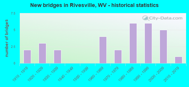
- New bridges - historical statistics
- 21910-1919
- 31920-1929
- 21930-1939
- 41960-1969
- 21970-1979
- 61980-1989
- 61990-1999
- 52000-2009
- 12010-2019


- Bridge Condition - Deck
- 11.8%Very good
- 41.2%Good
- 11.8%Satisfactory
- 17.6%Fair
- 17.6%Poor

- Bridge Condition - Superstructure
- 13.0%Very good
- 43.5%Good
- 4.3%Satisfactory
- 17.4%Fair
- 17.4%Poor
- 4.3%Serious

- Bridge Condition - Substructure
- 8.7%Very good
- 56.5%Good
- 34.8%Fair

- Bridge Condition - Channel
- 8.0%Excellent
- 12.0%Very good
- 24.0%Good
- 28.0%Satisfactory
- 24.0%Fair
- 4.0%Serious
Find on map >> Show street view
Structure Number: 25A03, Location: 0.08 MI WEST CO RT 17/17 (Lat: 39.543769, Lng: -80.144081), Route carried "on" structure: County highway 1700, Year Built: 1992, Status: Open, Structure Length: 1.85m (6.07ft), Average Daily Traffic: 1,700 (year 2018), Truck Traffic: 9%, Average Future Daily Traffic: 2,100 (year 2038), Design Load: HS 25 or greater, Features Intersected: LITTLE PAW PAW CREEK, Facility Carried by Structure: MARION CO RT 17
Minimum Vertical Clearance: 30+ m (98+ ft), Kilometerpoint: 15.289, Lanes on structure: 2, Owner: State Highway Agency, Approaching Roadway Width: 7.3m (24.0ft), Material/Design: Prestressed concrete, Design/Construction: Box Beam or Girders - Multiple, Number Of Spans In Main Unit: 1, Length of Maximum Span: 17.1m (56.1ft), Curb-To-Curb Width: 8.0m (26.2ft), Out-to-Out Width: 8.3m (27.2ft)
Condition: Deck: Good, Superstructure: Good, Substructure: Very good, Channel: Good, Operating Rating: 88.9 metric tons, Method Used To Determine Operating Rating: Load Factor (LF), Inventory Rating: 55.3 metric tons, Method Used To Determine Inventory Rating: Load Factor (LF), Structural Evaluation: Better than present minimum criteria, Deck Geometry: Meets minimum limits, Waterway Adequacy: Equal to present minimum criteria, Approach Roadway Alignment: Better than present minimum criteria, Designated Inspection Frequency: Every 48 months, Inspection Date: July 2020, Deck Structure Type: Other, Wearing Surface/Protective System: Wearing Surface: Bituminous, Deck Protection: Epoxy Coated Reinforcing
Find on map >> Show street view
Structure Number: 25A034, Location: 0.02 MI SOUTH CO RT 17 (Lat: 39.544050, Lng: -80.142431), Route carried "on" structure: County highway 1717, Year Built: 1992, Status: Open, Structure Length: 1.94m (6.36ft), Average Daily Traffic: 300 (year 2018), Truck Traffic: 9%, Average Future Daily Traffic: 375 (year 2038), Design Load: HS 25 or greater, Features Intersected: PAW PAW CREEK, Facility Carried by Structure: MARION CO RT 17/17
Minimum Vertical Clearance: 30+ m (98+ ft), Kilometerpoint: 0.966, Lanes on structure: 2, Owner: State Highway Agency, Approaching Roadway Width: 5.2m (17.1ft), Material/Design: Prestressed concrete, Design/Construction: Box Beam or Girders - Multiple, Number Of Spans In Main Unit: 1, Length of Maximum Span: 18.3m (60.0ft), Curb-To-Curb Width: 6.3m (20.7ft), Out-to-Out Width: 6.5m (21.3ft)
Condition: Deck: Fair, Superstructure: Fair, Substructure: Good, Channel: Excellent, Operating Rating: 88.9 metric tons, Method Used To Determine Operating Rating: Load Factor (LF), Inventory Rating: 71.7 metric tons, Method Used To Determine Inventory Rating: Load Factor (LF), Structural Evaluation: Somewhat better than minimum adequacy, Deck Geometry: Meets minimum limits, Waterway Adequacy: Better than present minimum criteria, Approach Roadway Alignment: Equal to present minimum criteria, Length Of Structure Improvement: 2.68m (8.79ft), Designated Inspection Frequency: Every 24 months, Inspection Date: June 2020, Bridge Improvement Cost: $362,000, Roadway Improvement Cost: $331,000, Total Project Cost: $709,000 ( Estimate for 2020), Deck Structure Type: Other, Wearing Surface/Protective System: Deck Protection: Epoxy Coated Reinforcing
Find on map >> Show street view
Structure Number: 25A044, Location: 0.01 MI NORTH CO RT 25 (Lat: 39.545481, Lng: -80.143361), Route carried "on" structure: County highway 2509, Year Built: 1925, Status: Open, Structure Length: 0.91m (2.99ft), Average Daily Traffic: 50 (year 2018), Average Future Daily Traffic: 60 (year 2038), Features Intersected: LITTLE PAW PAW CREEK, Facility Carried by Structure: MARION COUNTY 25/9
Minimum Vertical Clearance: 30+ m (98+ ft), Kilometerpoint: 0.016, Lanes on structure: 2, Owner: State Highway Agency, Approaching Roadway Width: 3.0m (9.8ft), Material/Design: Concrete, Design/Construction: Arch - Deck, Number Of Spans In Main Unit: 1, Length of Maximum Span: 9.1m (29.9ft), Curb or Sidewalk Widths: Left: 0.1m (0.3ft), Right: 0.1m (0.3ft), Curb-To-Curb Width: 5.3m (17.4ft), Out-to-Out Width: 6.2m (20.3ft)
Condition: Superstructure: Poor, Substructure: Fair, Channel: Fair, Operating Rating: 47.2 metric tons, Method Used To Determine Operating Rating: Field evaluation and documented engineering judgment, Inventory Rating: 21.8 metric tons, Method Used To Determine Inventory Rating: Field evaluation and documented engineering judgment, Structural Evaluation: Meets minimum limits, Deck Geometry: High priority of corrective action, Waterway Adequacy: Better than present minimum criteria, Approach Roadway Alignment: Somewhat better than minimum adequacy, Length Of Structure Improvement: 1.68m (5.51ft), Designated Inspection Frequency: Every 24 months, Inspection Date: July 2020, Bridge Improvement Cost: $204,000, Roadway Improvement Cost: $156,000, Total Project Cost: $432,000 ( Estimate for 2020)
Find on map >> Show street view
Structure Number: 25A049, Location: 0.06 MI NORTH CO RT 17 (Lat: 39.529450, Lng: -80.121089), Route carried "on" structure: US 1900, Year Built: 1968, Status: Open, Structure Length: 4.75m (15.58ft), Average Daily Traffic: 4,700 (year 2018), Truck Traffic: 5%, Average Future Daily Traffic: 5,775 (year 2038), Design Load: HS 20, Features Intersected: PAW PAW CREEK, Facility Carried by Structure: US ROUTE 19
Minimum Vertical Clearance: 30+ m (98+ ft), Kilometerpoint: 22.418, Lanes on structure: 2, Owner: State Highway Agency, Approaching Roadway Width: 9.4m (30.8ft), Material/Design: Steel continuous, Design/Construction: Stringer/Multi-beam, Number Of Spans In Main Unit: 1, Number Of Approach Spans: 2, Length of Maximum Span: 17.8m (58.4ft), Curb or Sidewalk Widths: Left: 1.2m (3.9ft), Right: 0.5m (1.6ft), Curb-To-Curb Width: 8.5m (27.9ft), Out-to-Out Width: 10.9m (35.8ft)
Condition: Deck: Fair, Superstructure: Good, Substructure: Fair, Channel: Fair, Operating Rating: 68.0 metric tons, Method Used To Determine Operating Rating: Load Factor (LF), Inventory Rating: 40.8 metric tons, Method Used To Determine Inventory Rating: Load Factor (LF), Structural Evaluation: Somewhat better than minimum adequacy, Deck Geometry: Meets minimum limits, Waterway Adequacy: Equal to present desirable criteria, Approach Roadway Alignment: Equal to present desirable criteria, Length Of Structure Improvement: 4.75m (15.58ft), Designated Inspection Frequency: Every 24 months, Underwater Inspection Frequency: Every 60 months, Inspection Date: October 2020, Underwater Inspection Date: September 2018, Bridge Improvement Cost: $345,000, Roadway Improvement Cost: $110,000, Total Project Cost: $492,000 ( Estimate for 2020), Deck Structure Type: Concrete Cast-file-Place, Wearing Surface/Protective System: Wearing Surface: Bituminous
Find on map >> Show street view
Structure Number: 25A052, Location: 0.03 MI SOUTH CO RT 19/3 (Lat: 39.531219, Lng: -80.117069), Route carried "on" structure: US 1900, Year Built: 1968, Status: Open, Structure Length: 1.09m (3.58ft), Average Daily Traffic: 4,700 (year 2018), Truck Traffic: 5%, Average Future Daily Traffic: 5,775 (year 2038), Design Load: HS 20, Features Intersected: PHARAOH RUN, Facility Carried by Structure: US ROUTE 19
Minimum Vertical Clearance: 30+ m (98+ ft), Kilometerpoint: 22.998, Lanes on structure: 2, Owner: State Highway Agency, Approaching Roadway Width: 7.6m (24.9ft), Skew: 2 degrees, Material/Design: Concrete, Design/Construction: Slab, Number Of Spans In Main Unit: 1, Length of Maximum Span: 9.8m (32.2ft), Curb or Sidewalk Widths: Left: 0.5m (1.6ft), Right: 0.5m (1.6ft), Curb-To-Curb Width: 13.4m (44.0ft), Out-to-Out Width: 15.0m (49.2ft)
Condition: Deck: Satisfactory, Superstructure: Satisfactory, Substructure: Fair, Channel: Serious, Operating Rating: 71.7 metric tons, Method Used To Determine Operating Rating: Field evaluation and documented engineering judgment, Inventory Rating: 32.7 metric tons, Method Used To Determine Inventory Rating: Field evaluation and documented engineering judgment, Structural Evaluation: Somewhat better than minimum adequacy, Deck Geometry: Better than present minimum criteria, Waterway Adequacy: Meets minimum limits, Approach Roadway Alignment: Better than present minimum criteria, Designated Inspection Frequency: Every 24 months, Inspection Date: September 2020, Deck Structure Type: Concrete Cast-file-Place, Wearing Surface/Protective System: Wearing Surface: Monolithic Concrete
Find on map >> Show street view
Structure Number: 25A056, Location: 0.46 MI SOUTH CO RT 19/5 (Lat: 39.550561, Lng: -80.099039), Route carried "on" structure: County highway 1906, Year Built: 1983, Status: Posted for load, Structure Length: 0.93m (3.05ft), Average Daily Traffic: 100 (year 2019), Average Future Daily Traffic: 155 (year 2041), Design Load: H 20, Features Intersected: BRANCH OF PARKER RUN, Facility Carried by Structure: MARION CO RT 19/6
Minimum Vertical Clearance: 30+ m (98+ ft), Kilometerpoint: 2.575, Lanes on structure: 1, Owner: State Highway Agency, Approaching Roadway Width: 3.7m (12.1ft), Material/Design: Steel, Design/Construction: Stringer/Multi-beam, Number Of Spans In Main Unit: 1, Length of Maximum Span: 8.5m (27.9ft), Curb-To-Curb Width: 3.7m (12.1ft), Out-to-Out Width: 3.7m (12.1ft)
Condition: Deck: Poor, Superstructure: Poor, Substructure: Fair, Channel: Good, Operating Rating: 30.8 metric tons, Method Used To Determine Operating Rating: Load Factor (LF), Inventory Rating: 18.1 metric tons, Method Used To Determine Inventory Rating: Load Factor (LF), Structural Evaluation: Meets minimum limits, Deck Geometry: Meets minimum limits, Waterway Adequacy: Superior to present desirable criteria, Approach Roadway Alignment: Meets minimum limits, Length Of Structure Improvement: 1.52m (4.99ft), Designated Inspection Frequency: Every 24 months, Inspection Date: June 2021, Bridge Improvement Cost: $192,000, Roadway Improvement Cost: $143,000, Total Project Cost: $409,000 ( Estimate for 2021), Deck Structure Type: Wood or Timber
Find on map >> Show street view
Structure Number: 25A076, Location: 0.02 MI WEST CO RT 17 (Lat: 39.537081, Lng: -80.138661), Route carried "on" structure: County highway 3000, Year Built: 1985, Status: Open, Structure Length: 2.29m (7.51ft), Average Daily Traffic: 300 (year 2019), Truck Traffic: 9%, Average Future Daily Traffic: 375 (year 2039), Design Load: HS 20, Features Intersected: PAW PAW CREEK, Facility Carried by Structure: MARION CO RT 30
Minimum Vertical Clearance: 30+ m (98+ ft), Kilometerpoint: 3.927, Lanes on structure: 2, Owner: State Highway Agency, Approaching Roadway Width: 5.5m (18.0ft), Material/Design: Prestressed concrete, Design/Construction: Box Beam or Girders - Multiple, Number Of Spans In Main Unit: 2, Length of Maximum Span: 10.7m (35.1ft), Curb-To-Curb Width: 7.0m (23.0ft), Out-to-Out Width: 7.3m (24.0ft)
Condition: Deck: Good, Superstructure: Good, Substructure: Good, Channel: Satisfactory, Operating Rating: 88.9 metric tons, Method Used To Determine Operating Rating: Load Factor (LF), Inventory Rating: 60.8 metric tons, Method Used To Determine Inventory Rating: Load Factor (LF), Structural Evaluation: Better than present minimum criteria, Deck Geometry: Meets minimum limits, Waterway Adequacy: Equal to present minimum criteria, Approach Roadway Alignment: Better than present minimum criteria, Designated Inspection Frequency: Every 48 months, Inspection Date: January 2021, Deck Structure Type: Other, Wearing Surface/Protective System: Wearing Surface: Bituminous, Deck Protection: Epoxy Coated Reinforcing
Find on map >> Show street view
Structure Number: 25A115, Location: 0.17 MI NORTH CO RT 73/4 (Lat: 39.514700, Lng: -80.098900), Route carried "on" structure: County highway 7200, Year Built: 1966, Status: Open, Structure Length: 2.10m (6.89ft), Average Daily Traffic: 600 (year 2019), Truck Traffic: 8%, Average Future Daily Traffic: 940 (year 2041), Design Load: HS 20, Features Intersected: PRICKETT CREEK, Facility Carried by Structure: MARION CO RT 72
Minimum Vertical Clearance: 30+ m (98+ ft), Kilometerpoint: 3.154, Lanes on structure: 2, Owner: State Highway Agency, Approaching Roadway Width: 7.6m (24.9ft), Skew: 2 degrees, Material/Design: Steel, Design/Construction: Stringer/Multi-beam, Number Of Spans In Main Unit: 1, Length of Maximum Span: 19.8m (65.0ft), Curb or Sidewalk Widths: Left: 0.5m (1.6ft), Right: 0.5m (1.6ft), Curb-To-Curb Width: 7.3m (24.0ft), Out-to-Out Width: 9.0m (29.5ft)
Condition: Deck: Fair, Superstructure: Good, Substructure: Good, Channel: Good, Operating Rating: 68.0 metric tons, Method Used To Determine Operating Rating: Load Factor (LF), Inventory Rating: 40.8 metric tons, Method Used To Determine Inventory Rating: Load Factor (LF), Structural Evaluation: Better than present minimum criteria, Deck Geometry: Meets minimum limits, Waterway Adequacy: Equal to present desirable criteria, Approach Roadway Alignment: Better than present minimum criteria, Designated Inspection Frequency: Every 24 months, Underwater Inspection Frequency: Every 60 months, Inspection Date: October 2021, Underwater Inspection Date: July 2020, Deck Structure Type: Concrete Cast-file-Place, Wearing Surface/Protective System: Wearing Surface: Monolithic Concrete
Find on map >> Show street view
Structure Number: 25A116, Location: 0.01 MI SOUTH CO RT 73/4 (Lat: 39.513239, Lng: -80.100839), Route carried "on" structure: County highway 7200, Year Built: 1988, Status: Open, Structure Length: 2.68m (8.79ft), Average Daily Traffic: 1,000 (year 2018), Truck Traffic: 9%, Average Future Daily Traffic: 1,225 (year 2038), Design Load: HS 20, Features Intersected: PRICKETT CREEK, Facility Carried by Structure: MARION CO RT 72
Minimum Vertical Clearance: 30+ m (98+ ft), Kilometerpoint: 2.865, Lanes on structure: 2, Owner: State Highway Agency, Approaching Roadway Width: 8.5m (27.9ft), Skew: 4 degrees, Material/Design: Steel, Design/Construction: Stringer/Multi-beam, Number Of Spans In Main Unit: 1, Length of Maximum Span: 24.7m (81.0ft), Curb-To-Curb Width: 8.8m (28.9ft), Out-to-Out Width: 9.8m (32.2ft)
Condition: Deck: Good, Superstructure: Good, Substructure: Good, Channel: Very good, Operating Rating: 88.9 metric tons, Method Used To Determine Operating Rating: Load Factor (LF), Inventory Rating: 66.2 metric tons, Method Used To Determine Inventory Rating: Load Factor (LF), Structural Evaluation: Better than present minimum criteria, Deck Geometry: Somewhat better than minimum adequacy, Waterway Adequacy: Equal to present desirable criteria, Approach Roadway Alignment: Equal to present minimum criteria, Designated Inspection Frequency: Every 48 months, Inspection Date: May 2020, Deck Structure Type: Concrete Cast-file-Place, Wearing Surface/Protective System: Wearing Surface: Monolithic Concrete, Deck Protection: Epoxy Coated Reinforcing
Find on map >> Show street view
Structure Number: 25A123, Location: 0.30 MI NORTH CO RT 73/6 (Lat: 39.518950, Lng: -80.071331), Route carried "on" structure: County highway 7400, Year Built: 1982, Status: Open, Structure Length: 0.82m (2.69ft), Average Daily Traffic: 525 (year 2016), Truck Traffic: 9%, Average Future Daily Traffic: 650 (year 2036), Design Load: HS 20, Features Intersected: LITTLE CREEK, Facility Carried by Structure: MARION CO RT 74
Minimum Vertical Clearance: 30+ m (98+ ft), Kilometerpoint: 0.483, Lanes on structure: 2, Owner: State Highway Agency, Approaching Roadway Width: 5.5m (18.0ft), Skew: 4 degrees, Material/Design: Concrete continuous, Design/Construction: Culvert, Number Of Spans In Main Unit: 1, Number Of Approach Spans: 2, Length of Maximum Span: 2.8m (9.2ft)
Condition: Channel: Satisfactory, Culverts: Good, Operating Rating: 71.7 metric tons, Method Used To Determine Operating Rating: Field evaluation and documented engineering judgment, Inventory Rating: 32.7 metric tons, Method Used To Determine Inventory Rating: Field evaluation and documented engineering judgment, Structural Evaluation: Better than present minimum criteria, Waterway Adequacy: Somewhat better than minimum adequacy, Approach Roadway Alignment: Better than present minimum criteria, Designated Inspection Frequency: Every 48 months, Inspection Date: May 2018
Find on map >> Show street view
Structure Number: 25A126, Location: 0.10 MI SOUTH CO RT 73/1 (Lat: 39.522231, Lng: -80.071419), Route carried "on" structure: County highway 7400, Year Built: 1922, Status: Posted for load, Structure Length: 0.91m (2.99ft), Average Daily Traffic: 500 (year 2019), Truck Traffic: 9%, Average Future Daily Traffic: 625 (year 2039), Features Intersected: LITTLE CREEK, Facility Carried by Structure: MARION CO. 74
Minimum Vertical Clearance: 30+ m (98+ ft), Kilometerpoint: 1.336, Lanes on structure: 2, Owner: State Highway Agency, Approaching Roadway Width: 6.1m (20.0ft), Skew: 3 degrees, Material/Design: Concrete, Design/Construction: Arch - Deck, Number Of Spans In Main Unit: 1, Length of Maximum Span: 9.1m (29.9ft), Curb or Sidewalk Widths: Left: 0.2m (0.7ft), Right: 0.2m (0.7ft), Curb-To-Curb Width: 5.3m (17.4ft), Out-to-Out Width: 5.7m (18.7ft)
Condition: Superstructure: Serious, Substructure: Fair, Channel: Fair, Operating Rating: 41.7 metric tons, Method Used To Determine Operating Rating: Field evaluation and documented engineering judgment, Inventory Rating: 19.0 metric tons, Method Used To Determine Inventory Rating: Field evaluation and documented engineering judgment, Structural Evaluation: High priority of corrective action, Deck Geometry: High priority of replacement, Waterway Adequacy: Better than present minimum criteria, Approach Roadway Alignment: Meets minimum limits, Length Of Structure Improvement: 1.65m (5.41ft), Designated Inspection Frequency: Every 24 months, Inspection Date: January 2021, Bridge Improvement Cost: $211,000, Roadway Improvement Cost: $162,000, Total Project Cost: $471,000 ( Estimate for 2021)
Find on map >> Show street view
Structure Number: 25A128, Location: 0.04 MI WEST CO RT 74 (Lat: 39.529069, Lng: -80.076139), Route carried "on" structure: County highway 7403, Year Built: 1995, Status: Open, Structure Length: 1.24m (4.07ft), Average Daily Traffic: 50 (year 2018), Average Future Daily Traffic: 60 (year 2038), Design Load: HS 25 or greater, Features Intersected: LITTLE CREEK, Facility Carried by Structure: MARION CO RT 74/3
Minimum Vertical Clearance: 30+ m (98+ ft), Kilometerpoint: 0.064, Lanes on structure: 2, Owner: State Highway Agency, Approaching Roadway Width: 7.6m (24.9ft), Skew: 1 degrees, Material/Design: Prestressed concrete, Design/Construction: Box Beam or Girders - Multiple, Number Of Spans In Main Unit: 1, Length of Maximum Span: 11.0m (36.1ft), Curb-To-Curb Width: 6.3m (20.7ft), Out-to-Out Width: 6.5m (21.3ft)
Condition: Deck: Good, Superstructure: Good, Substructure: Good, Channel: Satisfactory, Operating Rating: 88.9 metric tons, Method Used To Determine Operating Rating: Field evaluation and documented engineering judgment, Inventory Rating: 40.8 metric tons, Method Used To Determine Inventory Rating: Field evaluation and documented engineering judgment, Structural Evaluation: Better than present minimum criteria, Deck Geometry: Somewhat better than minimum adequacy, Waterway Adequacy: Equal to present minimum criteria, Approach Roadway Alignment: Equal to present desirable criteria, Designated Inspection Frequency: Every 48 months, Inspection Date: November 2020, Deck Structure Type: Other, Wearing Surface/Protective System: Wearing Surface: Bituminous, Deck Protection: Epoxy Coated Reinforcing
Find on map >> Show street view
Structure Number: 25A223, Location: 0.24 MI EAST CO RT 17/12 (Lat: 39.533511, Lng: -80.127900), Route carried "on" structure: County highway 1700, Year Built: 1996, Status: Open, Structure Length: 3.13m (10.27ft), Average Daily Traffic: 3,000 (year 2019), Truck Traffic: 8%, Average Future Daily Traffic: 4,680 (year 2041), Design Load: HS 25 or greater, Features Intersected: NORFOLK & SOUTHERN RR, Facility Carried by Structure: MARION CO RT 17
Minimum Vertical Clearance: 30+ m (98+ ft), Kilometerpoint: 18.218, Lanes on structure: 2, Owner: State Highway Agency, Approaching Roadway Width: 10.1m (33.1ft), Skew: 4 degrees, Material/Design: Steel, Design/Construction: Stringer/Multi-beam, Number Of Spans In Main Unit: 1, Length of Maximum Span: 29.9m (98.1ft), Curb-To-Curb Width: 9.1m (29.9ft), Out-to-Out Width: 10.2m (33.5ft)
Condition: Deck: Good, Superstructure: Good, Substructure: Good, Operating Rating: 88.9 metric tons, Method Used To Determine Operating Rating: Load Factor (LF), Inventory Rating: 73.5 metric tons, Method Used To Determine Inventory Rating: Load Factor (LF), Structural Evaluation: Better than present minimum criteria, Deck Geometry: Meets minimum limits, Underclear: High priority of replacement, Approach Roadway Alignment: Better than present minimum criteria, Length Of Structure Improvement: 3.81m (12.50ft), Designated Inspection Frequency: Every 24 months, Inspection Date: June 2021, Bridge Improvement Cost: $649,000, Roadway Improvement Cost: $114,000, Total Project Cost: $804,000 ( Estimate for 2021), Deck Structure Type: Concrete Cast-file-Place, Wearing Surface/Protective System: Deck Protection: Epoxy Coated Reinforcing
Find on map >> Show street view
Structure Number: 25A224, Location: 0.15 MI EAST CO RT 17/12 (Lat: 39.533881, Lng: -80.128861), Route carried "on" structure: County highway 1700, Year Built: 1996, Status: Open, Structure Length: 7.76m (25.46ft), Average Daily Traffic: 3,000 (year 2018), Truck Traffic: 9%, Average Future Daily Traffic: 3,675 (year 2038), Design Load: HS 25 or greater, Features Intersected: PAW PAW CREEK, Facility Carried by Structure: MARION CO RT 17
Minimum Vertical Clearance: 30+ m (98+ ft), Kilometerpoint: 18.073, Lanes on structure: 2, Owner: State Highway Agency, Approaching Roadway Width: 10.1m (33.1ft), Material/Design: Steel continuous, Design/Construction: Stringer/Multi-beam, Number Of Spans In Main Unit: 2, Number Of Approach Spans: 2, Length of Maximum Span: 22.3m (73.2ft), Curb-To-Curb Width: 9.1m (29.9ft), Out-to-Out Width: 10.2m (33.5ft)
Condition: Deck: Satisfactory, Superstructure: Very good, Substructure: Good, Channel: Fair, Operating Rating: 81.6 metric tons, Method Used To Determine Operating Rating: Load Factor (LF), Inventory Rating: 49.0 metric tons, Method Used To Determine Inventory Rating: Load Factor (LF), Structural Evaluation: Better than present minimum criteria, Deck Geometry: Meets minimum limits, Waterway Adequacy: Superior to present desirable criteria, Approach Roadway Alignment: Somewhat better than minimum adequacy, Designated Inspection Frequency: Every 24 months, Inspection Date: October 2020, Deck Structure Type: Concrete Cast-file-Place, Wearing Surface/Protective System: Deck Protection: Epoxy Coated Reinforcing
Find on map >> Show street view
Structure Number: 25A228, Location: 0.04 MI EAST U.S. RT 19 (Lat: 39.553239, Lng: -80.118911), Route carried "on" structure: County highway 1902, Year Built: 1997, Status: Open, Structure Length: 0.97m (3.18ft), Average Daily Traffic: 100 (year 2018), Average Future Daily Traffic: 125 (year 2038), Design Load: HS 25 or greater, Features Intersected: PHARAOH RUN, Facility Carried by Structure: MARION CO RT 19/2
Minimum Vertical Clearance: 30+ m (98+ ft), Kilometerpoint: 0.064, Lanes on structure: 2, Owner: State Highway Agency, Approaching Roadway Width: 4.3m (14.1ft), Skew: 4 degrees, Material/Design: Prestressed concrete, Design/Construction: Box Beam or Girders - Multiple, Number Of Spans In Main Unit: 1, Length of Maximum Span: 7.9m (25.9ft), Curb-To-Curb Width: 5.5m (18.0ft), Out-to-Out Width: 5.5m (18.0ft)
Condition: Superstructure: Good, Substructure: Good, Channel: Satisfactory, Operating Rating: 78.0 metric tons, Method Used To Determine Operating Rating: Load Factor (LF), Inventory Rating: 47.2 metric tons, Method Used To Determine Inventory Rating: Load Factor (LF), Structural Evaluation: Better than present minimum criteria, Deck Geometry: Meets minimum limits, Waterway Adequacy: Better than present minimum criteria, Approach Roadway Alignment: Equal to present minimum criteria, Designated Inspection Frequency: Every 48 months, Inspection Date: October 2019, Deck Structure Type: Other, Wearing Surface/Protective System: Wearing Surface: Bituminous, Deck Protection: Epoxy Coated Reinforcing
Find on map >> Show street view
Structure Number: 25A236, Location: 0.01 MILE NORTH US RT 19 (Lat: 39.529700, Lng: -80.116600), Route carried "on" structure: County highway 1984, Year Built: 1967, Status: Open, Structure Length: 1.67m (5.48ft), Average Daily Traffic: 50 (year 2019), Truck Traffic: 8%, Average Future Daily Traffic: 80 (year 2041), Design Load: HS 20, Features Intersected: PHARAOH RUN, Facility Carried by Structure: MARION CO RT 19/84
Minimum Vertical Clearance: 30+ m (98+ ft), Kilometerpoint: 0.016, Lanes on structure: 2, Owner: State Highway Agency, Approaching Roadway Width: 7.3m (24.0ft), Material/Design: Prestressed concrete, Design/Construction: Box Beam or Girders - Multiple, Number Of Spans In Main Unit: 1, Length of Maximum Span: 15.2m (49.9ft), Curb or Sidewalk Widths: Left: 0.5m (1.6ft), Right: 0.5m (1.6ft), Curb-To-Curb Width: 7.6m (24.9ft), Out-to-Out Width: 9.7m (31.8ft)
Condition: Superstructure: Fair, Substructure: Good, Channel: Fair, Operating Rating: 45.4 metric tons, Method Used To Determine Operating Rating: Load Factor (LF), Inventory Rating: 27.2 metric tons, Method Used To Determine Inventory Rating: Load Factor (LF), Structural Evaluation: Somewhat better than minimum adequacy, Deck Geometry: Equal to present minimum criteria, Waterway Adequacy: Equal to present minimum criteria, Approach Roadway Alignment: Better than present minimum criteria, Designated Inspection Frequency: Every 24 months, Underwater Inspection Frequency: Every 60 months, Inspection Date: October 2021, Underwater Inspection Date: June 2017, Deck Structure Type: Other, Wearing Surface/Protective System: Wearing Surface: Bituminous
Find on map >> Show street view
Structure Number: 25A241, Location: 0.16 MI SOUTH CO RT 19/21 (Lat: 39.543311, Lng: -80.118939), Route carried "on" structure: US 1900, Year Built: 2000, Status: Open, Structure Length: 0.79m (2.59ft), Average Daily Traffic: 3,050 (year 2017), Truck Traffic: 5%, Average Future Daily Traffic: 3,750 (year 2037), Design Load: HS 25 or greater, Features Intersected: PHARAOH RUN, Facility Carried by Structure: US ROUTE 19
Minimum Vertical Clearance: 30+ m (98+ ft), Kilometerpoint: 24.446, Lanes on structure: 2, Owner: State Highway Agency, Approaching Roadway Width: 6.7m (22.0ft), Skew: 4 degrees, Material/Design: Concrete, Design/Construction: Culvert, Number Of Spans In Main Unit: 1, Length of Maximum Span: 7.8m (25.6ft), Curb-To-Curb Width: 9.3m (30.5ft), Out-to-Out Width: 10.4m (34.1ft)
Condition: Channel: Satisfactory, Culverts: Good, Operating Rating: 88.9 metric tons, Method Used To Determine Operating Rating: Field evaluation and documented engineering judgment, Inventory Rating: 40.8 metric tons, Method Used To Determine Inventory Rating: Field evaluation and documented engineering judgment, Structural Evaluation: Better than present minimum criteria, Deck Geometry: Meets minimum limits, Waterway Adequacy: Equal to present desirable criteria, Approach Roadway Alignment: Equal to present minimum criteria, Designated Inspection Frequency: Every 48 months, Inspection Date: January 2019, Deck Structure Type: Other
Find on map >> Show street view
Structure Number: 25A243, Location: 0.07 MI NORTH CO RT 19/2 (Lat: 39.553939, Lng: -80.119689), Route carried "on" structure: US 1900, Year Built: 2000, Status: Open, Structure Length: 0.81m (2.66ft), Average Daily Traffic: 2,425 (year 2017), Truck Traffic: 5%, Average Future Daily Traffic: 2,975 (year 2037), Design Load: HS 25 or greater, Features Intersected: PHARAOH RUN, Facility Carried by Structure: US ROUTE 19
Minimum Vertical Clearance: 30+ m (98+ ft), Kilometerpoint: 25.637, Lanes on structure: 2, Owner: State Highway Agency, Approaching Roadway Width: 7.0m (23.0ft), Skew: 5 degrees, Material/Design: Concrete, Design/Construction: Culvert, Number Of Spans In Main Unit: 1, Length of Maximum Span: 8.1m (26.6ft), Curb-To-Curb Width: 9.5m (31.2ft), Out-to-Out Width: 10.4m (34.1ft)
Condition: Channel: Fair, Culverts: Good, Operating Rating: 88.9 metric tons, Method Used To Determine Operating Rating: Field evaluation and documented engineering judgment, Inventory Rating: 45.4 metric tons, Method Used To Determine Inventory Rating: Field evaluation and documented engineering judgment, Structural Evaluation: Better than present minimum criteria, Deck Geometry: Meets minimum limits, Waterway Adequacy: Equal to present desirable criteria, Approach Roadway Alignment: Better than present minimum criteria, Designated Inspection Frequency: Every 48 months, Inspection Date: January 2019, Deck Structure Type: Other
Find on map >> Show street view
Structure Number: 25A246, Location: 0.20 MILE NORTH MRN 73/6 (Lat: 39.516869, Lng: -80.070750), Route carried "on" structure: County highway 7400, Year Built: 2001, Status: Open, Structure Length: 1.11m (3.64ft), Average Daily Traffic: 500 (year 2019), Truck Traffic: 8%, Average Future Daily Traffic: 780 (year 2041), Design Load: HS 25 or greater, Features Intersected: LITTLE CREEK, Facility Carried by Structure: MARION CO RT 74
Minimum Vertical Clearance: 30+ m (98+ ft), Kilometerpoint: 0.322, Lanes on structure: 2, Owner: State Highway Agency, Approaching Roadway Width: 5.5m (18.0ft), Skew: 2 degrees, Material/Design: Prestressed concrete, Design/Construction: Box Beam or Girders - Multiple, Number Of Spans In Main Unit: 1, Length of Maximum Span: 10.1m (33.1ft), Curb-To-Curb Width: 5.5m (18.0ft), Out-to-Out Width: 5.6m (18.4ft)
Condition: Superstructure: Good, Substructure: Good, Channel: Very good, Operating Rating: 88.9 metric tons, Method Used To Determine Operating Rating: Load Factor (LF), Inventory Rating: 53.5 metric tons, Method Used To Determine Inventory Rating: Load Factor (LF), Structural Evaluation: Better than present minimum criteria, Deck Geometry: High priority of replacement, Waterway Adequacy: Better than present minimum criteria, Approach Roadway Alignment: Equal to present minimum criteria, Designated Inspection Frequency: Every 24 months, Inspection Date: July 2021, Deck Structure Type: Other, Wearing Surface/Protective System: Deck Protection: Epoxy Coated Reinforcing
Find on map >> Show street view
Structure Number: 25A261, Location: 0.39 MI SOUTH CO RT 73/1 (Lat: 39.518911, Lng: -80.071669), Route carried "on" structure: County highway 7400, Year Built: 2008, Status: Open, Structure Length: 1.25m (4.10ft), Average Daily Traffic: 525 (year 2017), Truck Traffic: 9%, Average Future Daily Traffic: 650 (year 2037), Design Load: HL 93, Features Intersected: LITTLE CREEK, Facility Carried by Structure: MARION CO RT 74
Minimum Vertical Clearance: 30+ m (98+ ft), Kilometerpoint: 0.869, Lanes on structure: 2, Owner: State Highway Agency, Approaching Roadway Width: 5.2m (17.1ft), Skew: 3 degrees, Material/Design: Prestressed concrete, Design/Construction: Box Beam or Girders - Multiple, Number Of Spans In Main Unit: 1, Length of Maximum Span: 11.0m (36.1ft), Curb-To-Curb Width: 7.4m (24.3ft), Out-to-Out Width: 7.4m (24.3ft)
Condition: Deck: Very good, Superstructure: Very good, Substructure: Good, Channel: Good, Operating Rating: 85.3 metric tons, Method Used To Determine Operating Rating: Load and Resistance Factor (LRFR), Inventory Rating: 65.3 metric tons, Method Used To Determine Inventory Rating: Load and Resistance Factor (LRFR), Structural Evaluation: Better than present minimum criteria, Deck Geometry: Meets minimum limits, Waterway Adequacy: Better than present minimum criteria, Approach Roadway Alignment: Meets minimum limits, Designated Inspection Frequency: Every 48 months, Inspection Date: January 2019, Deck Structure Type: Other, Wearing Surface/Protective System: Deck Protection: Epoxy Coated Reinforcing
Find on map >> Show street view
Structure Number: 31A097, Location: 0.01 MI WEST CO RT 37 (Lat: 39.586639, Lng: -80.110900), Route carried "on" structure: County highway 3708, Year Built: 1976, Status: Open, Structure Length: 1.27m (4.17ft), Average Daily Traffic: 10 (year 2019), Average Future Daily Traffic: 18 (year 2041), Design Load: H 20, Features Intersected: INDIAN CREEK, Facility Carried by Structure: MONONGALIA CR 37/8
Minimum Vertical Clearance: 30+ m (98+ ft), Kilometerpoint: 0.016, Lanes on structure: 1, Owner: State Highway Agency, Approaching Roadway Width: 3.7m (12.1ft), Skew: 2 degrees, Material/Design: Steel, Design/Construction: Stringer/Multi-beam, Number Of Spans In Main Unit: 1, Length of Maximum Span: 11.6m (38.1ft), Curb-To-Curb Width: 4.9m (16.1ft), Out-to-Out Width: 4.9m (16.1ft)
Condition: Deck: Good, Superstructure: Fair, Substructure: Good, Channel: Good, Operating Rating: 62.6 metric tons, Method Used To Determine Operating Rating: Load Factor (LF), Inventory Rating: 38.1 metric tons, Method Used To Determine Inventory Rating: Load Factor (LF), Structural Evaluation: Somewhat better than minimum adequacy, Deck Geometry: High priority of corrective action, Waterway Adequacy: Equal to present minimum criteria, Approach Roadway Alignment: Better than present minimum criteria, Designated Inspection Frequency: Every 24 months, Inspection Date: July 2021, Deck Structure Type: Wood or Timber
Find on map >> Show street view
Structure Number: 31A107, Location: 0.05 MI EAST CO RT 45/1 (Lat: 39.573069, Lng: -80.080450), Route carried "on" structure: County highway 4500, Year Built: 1935, Status: Open, Structure Length: 0.87m (2.85ft), Average Daily Traffic: 450 (year 2019), Truck Traffic: 6%, Average Future Daily Traffic: 607 (year 2041), Features Intersected: LITTLE INDIAN CREEK, Facility Carried by Structure: MONONGALIA CR 45
Minimum Vertical Clearance: 30+ m (98+ ft), Kilometerpoint: 1.690, Lanes on structure: 2, Owner: State Highway Agency, Approaching Roadway Width: 6.1m (20.0ft), Skew: 3 degrees, Material/Design: Concrete, Design/Construction: Slab, Number Of Spans In Main Unit: 1, Length of Maximum Span: 7.1m (23.3ft), Curb or Sidewalk Widths: Left: 0.1m (0.3ft), Right: 0.1m (0.3ft), Curb-To-Curb Width: 5.5m (18.0ft), Out-to-Out Width: 6.3m (20.7ft)
Condition: Superstructure: Poor, Substructure: Fair, Channel: Satisfactory, Operating Rating: 57.1 metric tons, Method Used To Determine Operating Rating: Field evaluation and documented engineering judgment, Inventory Rating: 26.3 metric tons, Method Used To Determine Inventory Rating: Field evaluation and documented engineering judgment, Structural Evaluation: Meets minimum limits, Deck Geometry: High priority of replacement, Waterway Adequacy: Equal to present desirable criteria, Approach Roadway Alignment: Equal to present desirable criteria, Length Of Structure Improvement: 1.49m (4.89ft), Designated Inspection Frequency: Every 24 months, Inspection Date: July 2021, Bridge Improvement Cost: $211,000, Roadway Improvement Cost: $163,000, Total Project Cost: $444,000 ( Estimate for 2021), Deck Structure Type: Concrete Cast-file-Place, Wearing Surface/Protective System: Wearing Surface: Bituminous
Find on map >> Show street view
Structure Number: 31A108, Location: 0.05 MI WEST CO RT 45/5 (Lat: 39.564061, Lng: -80.064611), Route carried "on" structure: County highway 4500, Year Built: 1930, Status: Posted for load, Structure Length: 1.62m (5.31ft), Average Daily Traffic: 450 (year 2019), Truck Traffic: 6%, Average Future Daily Traffic: 700 (year 2041), Features Intersected: INDIAN CREEK, Facility Carried by Structure: MONONGALIA CR 45
Minimum Vertical Clearance: 30+ m (98+ ft), Kilometerpoint: 3.895, Lanes on structure: 2, Owner: State Highway Agency, Approaching Roadway Width: 6.4m (21.0ft), Material/Design: Concrete, Design/Construction: Tee Beam, Number Of Spans In Main Unit: 1, Length of Maximum Span: 15.0m (49.2ft), Curb or Sidewalk Widths: Left: 0.1m (0.3ft), Right: 0.1m (0.3ft), Curb-To-Curb Width: 5.5m (18.0ft), Out-to-Out Width: 6.4m (21.0ft)
Condition: Deck: Poor, Superstructure: Poor, Substructure: Fair, Channel: Good, Operating Rating: 28.1 metric tons, Method Used To Determine Operating Rating: Field evaluation and documented engineering judgment, Inventory Rating: 11.8 metric tons, Method Used To Determine Inventory Rating: Field evaluation and documented engineering judgment, Structural Evaluation: Meets minimum limits, Deck Geometry: High priority of replacement, Waterway Adequacy: Equal to present desirable criteria, Approach Roadway Alignment: High priority of replacement, Length Of Structure Improvement: 2.35m (7.71ft), Designated Inspection Frequency: Every 24 months, Inspection Date: March 2021, Bridge Improvement Cost: $287,000, Roadway Improvement Cost: $242,000, Total Project Cost: $653,000 ( Estimate for 2021), Deck Structure Type: Concrete Cast-file-Place, Wearing Surface/Protective System: Wearing Surface: Bituminous
Find on map >> Show street view
Structure Number: 31A111, Location: 0.14 MI EAST CO RT 45/5 (Lat: 39.562331, Lng: -80.061711), Route carried "on" structure: County highway 4500, Year Built: 1989, Status: Open, Structure Length: 2.70m (8.86ft), Average Daily Traffic: 450 (year 2018), Truck Traffic: 6%, Average Future Daily Traffic: 600 (year 2038), Design Load: HS 25 or greater, Features Intersected: LITTLE INDIAN CREEK, Facility Carried by Structure: MONONGALIA CR 45
Minimum Vertical Clearance: 30+ m (98+ ft), Kilometerpoint: 4.200, Lanes on structure: 2, Owner: State Highway Agency, Approaching Roadway Width: 6.4m (21.0ft), Skew: 4 degrees, Material/Design: Prestressed concrete, Design/Construction: Box Beam or Girders - Multiple, Number Of Spans In Main Unit: 1, Length of Maximum Span: 25.6m (84.0ft), Curb-To-Curb Width: 7.1m (23.3ft), Out-to-Out Width: 7.4m (24.3ft)
Condition: Deck: Good, Superstructure: Good, Substructure: Good, Channel: Excellent, Operating Rating: 88.9 metric tons, Method Used To Determine Operating Rating: Load Factor (LF), Inventory Rating: 63.5 metric tons, Method Used To Determine Inventory Rating: Load Factor (LF), Structural Evaluation: Better than present minimum criteria, Deck Geometry: Meets minimum limits, Waterway Adequacy: Superior to present desirable criteria, Approach Roadway Alignment: Better than present minimum criteria, Designated Inspection Frequency: Every 48 months, Inspection Date: September 2019, Deck Structure Type: Other, Wearing Surface/Protective System: Wearing Surface: Bituminous, Deck Protection: Epoxy Coated Reinforcing
Find on map >> Show street view
Structure Number: 31A116, Location: 0.07 MI WEST MGL CR 45 (Lat: 39.569039, Lng: -80.079989), Route carried "on" structure: County highway 4502, Year Built: 1974, Status: Open, Structure Length: 1.36m (4.46ft), Average Daily Traffic: 50 (year 2018), Average Future Daily Traffic: 70 (year 2038), Features Intersected: INDIAN CREEK, Facility Carried by Structure: MONONGALIA CR 45/2
Minimum Vertical Clearance: 30+ m (98+ ft), Kilometerpoint: 1.609, Lanes on structure: 1, Owner: State Highway Agency, Approaching Roadway Width: 4.3m (14.1ft), Material/Design: Steel, Design/Construction: Stringer/Multi-beam, Number Of Spans In Main Unit: 1, Length of Maximum Span: 12.5m (41.0ft), Curb-To-Curb Width: 4.2m (13.8ft), Out-to-Out Width: 4.3m (14.1ft)
Condition: Deck: Poor, Superstructure: Fair, Substructure: Fair, Channel: Satisfactory, Operating Rating: 56.2 metric tons, Method Used To Determine Operating Rating: Load Factor (LF), Inventory Rating: 33.6 metric tons, Method Used To Determine Inventory Rating: Load Factor (LF), Structural Evaluation: Somewhat better than minimum adequacy, Deck Geometry: Somewhat better than minimum adequacy, Waterway Adequacy: Equal to present desirable criteria, Approach Roadway Alignment: Meets minimum limits, Length Of Structure Improvement: 2.01m (6.59ft), Designated Inspection Frequency: Every 24 months, Inspection Date: September 2020, Bridge Improvement Cost: $207,000, Roadway Improvement Cost: $181,000, Total Project Cost: $453,000 ( Estimate for 2020), Deck Structure Type: Wood or Timber
Find on map >> Show street view
Structure Number: 31A332, Location: 0.06 miles S of Mon Co 45 (Lat: 39.576800, Lng: -80.097100), Route carried "on" structure: US 19, Year Built: 2019, Status: Open, Structure Length: 2.29m (7.51ft), Average Daily Traffic: 2,500 (year 2018), Truck Traffic: 4%, Average Future Daily Traffic: 3,400 (year 2038), Design Load: HL 93, Features Intersected: INDIAN CREEK
Minimum Vertical Clearance: 30+ m (98+ ft), Kilometerpoint: 1.078, Lanes on structure: 2, Owner: State Highway Agency, Approaching Roadway Width: 9.1m (29.9ft), Skew: 1 degrees, Material/Design: Prestressed concrete, Design/Construction: Stringer/Multi-beam, Number Of Spans In Main Unit: 1, Length of Maximum Span: 21.8m (71.5ft), Curb-To-Curb Width: 9.1m (29.9ft), Out-to-Out Width: 9.9m (32.5ft)
Condition: Deck: Very good, Superstructure: Very good, Substructure: Very good, Channel: Very good, Operating Rating: 46.3 metric tons, Method Used To Determine Operating Rating: Load and Resistance Factor (LRFR), Inventory Rating: 36.3 metric tons, Method Used To Determine Inventory Rating: Load and Resistance Factor (LRFR), Structural Evaluation: Equal to present desirable criteria, Deck Geometry: Meets minimum limits, Waterway Adequacy: Equal to present desirable criteria, Approach Roadway Alignment: Equal to present minimum criteria, Designated Inspection Frequency: Every 24 months, Inspection Date: August 2020, Deck Structure Type: Concrete Cast-file-Place, Wearing Surface/Protective System: Deck Protection: Epoxy Coated Reinforcing
Find on map >> Show street view
Structure Number: 25A05, Location: 0.05 MI SOUTH CR 19/3 (Lat: 39.530511, Lng: -80.116739), Route carried "under" structure: US 1900, Year Built: 1929, Structure Length: 0. m, Average Daily Traffic: 4,700 (year 2019), Truck Traffic: 5%, Features Intersected: NORFOLK SOUTHERN RR, Facility Carried by Structure: NORFOLK SOUTHERN
Minimum Vertical Clearance: 4.55m (14.93ft), Kilometerpoint: 22.933, Lanes under structure: 2, Length of Maximum Span: 11.8m (38.7ft)
Find on map >> Show street view
Structure Number: 25A051, Location: 0.04 MI SOUTH CR 19/3 (Lat: 39.530681, Lng: -80.116761), Route carried "under" structure: US 1900, Year Built: 1986, Structure Length: 0. m, Average Daily Traffic: 4,700 (year 2019), Truck Traffic: 5%, Features Intersected: WALKWAY, Facility Carried by Structure: PEDESTRIAN BRIDGE
Minimum Vertical Clearance: 4.85m (15.91ft), Kilometerpoint: 22.949, Lanes under structure: 2, Length of Maximum Span: 16.5m (54.1ft)
Find on map >> Show street view
Structure Number: 25A057, Location: 0.02 MI WEST US ROUTE 19 (Lat: 39.522600, Lng: -80.133639), Route carried "under" structure: County highway 1907, Year Built: 1919, Structure Length: 0. m, Average Daily Traffic: 50 (year 2019), Features Intersected: WALKWAY, Facility Carried by Structure: WALKWAY
Minimum Vertical Clearance: 4.83m (15.85ft), Kilometerpoint: 2.672, Lanes under structure: 2, Length of Maximum Span: 13.2m (43.3ft)
Find on map >> Show street view
Structure Number: 25A058, Location: 0.01 MI WEST US RT 19 (Lat: 39.522500, Lng: -80.133481), Route carried "under" structure: County highway 1907, Year Built: 2005, Structure Length: 0. m, Average Daily Traffic: 50 (year 2019), Features Intersected: NORFOLK SOUTHERN RR, Facility Carried by Structure: NORFOLK & SOUTHERN
Minimum Vertical Clearance: 3.28m (10.76ft), Kilometerpoint: 2.688, Lanes under structure: 1, Length of Maximum Span: 6.6m (21.7ft)
Find on map >> Show street view
Structure Number: 25A117, Location: 0.31 MI NORTH CR 73/4 (Lat: 39.518400, Lng: -80.091431), Route carried "under" structure: County highway 7200, Year Built: 1913, Structure Length: 0. m, Average Daily Traffic: 300 (year 2019), Truck Traffic: 9%, Features Intersected: Marion Co. Rt. 72, Facility Carried by Structure: MAR CO PARKS TRAIL
Minimum Vertical Clearance: 3.63m (11.91ft), Kilometerpoint: 3.380, Lanes under structure: 2, Length of Maximum Span: 7.9m (25.9ft)