Bridge Statistics for Roanoke, Texas (TX)
Condition, Traffic, Stress, Structural Evaluation, Project Costs
- National Bridge Inventory (NBI) Statistics
- 20Number of bridges
- 541ft / 165mTotal length
- $844,000Total costs
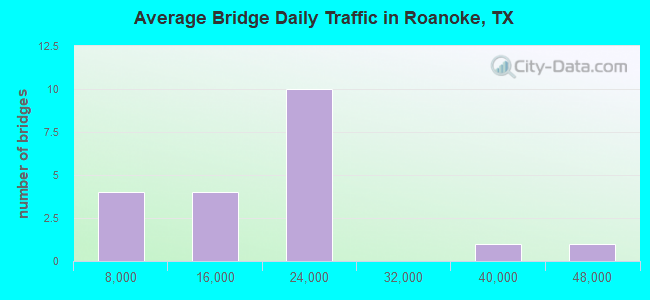
- 371,024Total average daily traffic
- 24,434Total average daily truck traffic
- National Bridge Inventory (NBI) Registered Bridges for Roanoke
- No street view available for this location
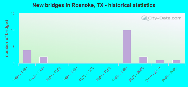
- New bridges - historical statistics
- 41930-1939
- 21940-1949
- 101990-1999
- 22000-2009
- 12010-2019
- 12020-2022
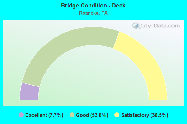
- Bridge Condition - Deck
- 7.7%Excellent
- 53.8%Good
- 38.5%Satisfactory
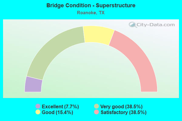
- Bridge Condition - Superstructure
- 7.7%Excellent
- 38.5%Very good
- 15.4%Good
- 38.5%Satisfactory
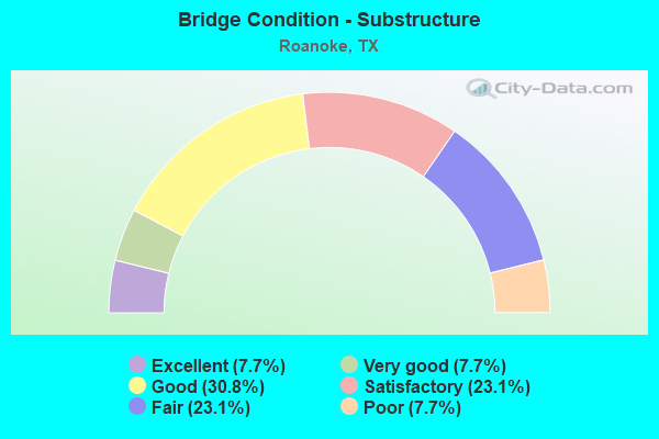
- Bridge Condition - Substructure
- 7.7%Excellent
- 7.7%Very good
- 30.8%Good
- 23.1%Satisfactory
- 23.1%Fair
- 7.7%Poor
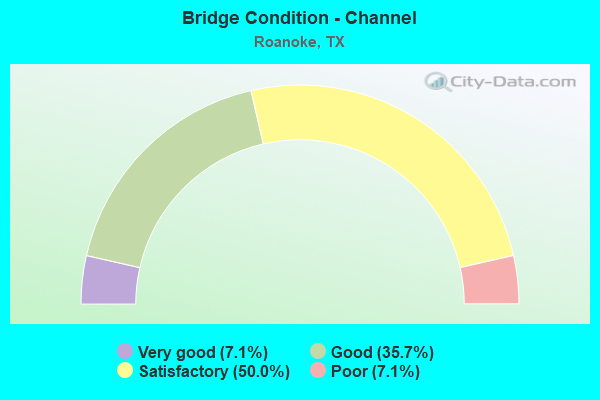
- Bridge Condition - Channel
- 7.1%Very good
- 35.7%Good
- 50.0%Satisfactory
- 7.1%Poor
Find on map >> Show street view
Structure Number: 180610008103149, Location: 0.70 MI S OF SH 114 (Lat: 33.004581, Lng: -97.227331), Route carried "on" structure: US 377, Year Built: 1940, Status: Closed, Structure Length: 2.90m (9.51ft), Average Daily Traffic: 14,833 (year 2020), Truck Traffic: 9%, Average Future Daily Traffic: 11,410 (year 2033), Design Load: H 15, Features Intersected: SH 114 BUSINESS
Minimum Vertical Clearance: 30+ m (98+ ft), Kilometerpoint: 19.850, Lanes on structure: 2, Lanes under structure: 2, Owner: State Highway Agency, Approaching Roadway Width: 7.9m (25.9ft), Material/Design: Steel, Design/Construction: Stringer/Multi-beam, Number Of Spans In Main Unit: 3, Length of Maximum Span: 10.7m (35.1ft), Curb-To-Curb Width: 7.7m (25.3ft), Out-to-Out Width: 9.5m (31.2ft)
Condition: Deck: Satisfactory, Superstructure: Satisfactory, Substructure: Fair, Approach Roadway Alignment: Equal to present desirable criteria, Length Of Structure Improvement: 2.90m (9.51ft), Designated Inspection Frequency: Every 24 months, Inspection Date: September 2021, Bridge Improvement Cost: $5,000, Roadway Improvement Cost: $1,000, Total Project Cost: $6,000, Deck Structure Type: Concrete Cast-file-Place, Wearing Surface/Protective System: Wearing Surface: Bituminous
Find on map >> Show street view
Structure Number: 18061000810318, Location: 1.70 MI N OF SH 114 (Lat: 33.033942, Lng: -97.210097), Route carried "on" structure: US 377, Year Built: 1991, Status: Open, Structure Length: 7.77m (25.49ft), Average Daily Traffic: 14,833 (year 2020), Truck Traffic: 9%, Average Future Daily Traffic: 22,830 (year 2033), Design Load: HS 20, Features Intersected: DENTON CREEK RELIEF
Minimum Vertical Clearance: 30+ m (98+ ft), Kilometerpoint: 16.182, Lanes on structure: 2, Owner: State Highway Agency, Approaching Roadway Width: 12.8m (42.0ft), Material/Design: Prestressed concrete, Design/Construction: Stringer/Multi-beam, Number Of Spans In Main Unit: 3, Length of Maximum Span: 25.9m (85.0ft), Curb-To-Curb Width: 13.2m (43.3ft), Out-to-Out Width: 14.0m (45.9ft)
Condition: Deck: Good, Superstructure: Good, Substructure: Good, Channel: Good, Operating Rating: 54.4 metric tons, Method Used To Determine Operating Rating: Assigned rating based on Load Factor Design (LFD) reported in metric tons, Inventory Rating: 32.7 metric tons, Method Used To Determine Inventory Rating: Assigned rating based on Load Factor Design (LFD) reported in metric tons, Structural Evaluation: Better than present minimum criteria, Deck Geometry: Somewhat better than minimum adequacy, Waterway Adequacy: Superior to present desirable criteria, Approach Roadway Alignment: Equal to present desirable criteria, Designated Inspection Frequency: Every 24 months, Inspection Date: September 2021, Deck Structure Type: Concrete Precast Panels
Find on map >> Show street view
Structure Number: 180610008103315, Location: 0.70 MI S OF SH 114 (Lat: 33.004653, Lng: -97.227289), Route carried "on" structure: US 377, Year Built: 2021, Status: Open, Structure Length: 2.82m (9.25ft), Average Daily Traffic: 13,289 (year 2020), Truck Traffic: 5%, Average Future Daily Traffic: 18,605 (year 2040), Design Load: HL 93, Features Intersected: SH 114 BUSINESS
Minimum Vertical Clearance: 30+ m (98+ ft), Kilometerpoint: 19.850, Lanes on structure: 4, Lanes under structure: 2, Owner: State Highway Agency, Maintenance Responsibility: State Agenciy, Approaching Roadway Width: 24.1m (79.1ft), Material/Design: Prestressed concrete, Design/Construction: Stringer/Multi-beam, Number Of Spans In Main Unit: 1, Length of Maximum Span: 28.2m (92.5ft), Curb or Sidewalk Widths: Left: 0.0m, Right: 1.8m (5.9ft), Curb-To-Curb Width: 24.1m (79.1ft), Out-to-Out Width: 24.7m (81.0ft)
Condition: Deck: Excellent, Superstructure: Excellent, Substructure: Excellent, Operating Rating: 54.4 metric tons, Method Used To Determine Operating Rating: Assigned ratings based on Load and Resistance Factor Design (LRFD) reported in metric tons, Inventory Rating: 32.7 metric tons, Method Used To Determine Inventory Rating: Assigned ratings based on Load and Resistance Factor Design (LRFD) reported in metric tons, Structural Evaluation: Superior to present desirable criteria, Deck Geometry: Superior to present desirable criteria, Underclear: High priority of corrective action, Approach Roadway Alignment: Equal to present desirable criteria, Designated Inspection Frequency: Every 24 months, Inspection Date: October 2021, Deck Structure Type: Concrete Cast-file-Place, Wearing Surface/Protective System: Deck Protection: Epoxy Coated Reinforcing
Find on map >> Show street view
Structure Number: 180610008103366, Location: 0.02 MI N of Tarrant C/L (Lat: 32.991336, Lng: -97.234486), Route carried "on" structure: US 377, Year Built: 1992, Status: Open, Structure Length: 1.52m (4.99ft), Average Daily Traffic: 17,600 (year 2019), Truck Traffic: 4%, Average Future Daily Traffic: 21,150 (year 2039), Design Load: HS 20, Features Intersected: Marshall Crk Trib
Minimum Vertical Clearance: 30+ m (98+ ft), Kilometerpoint: 21.525, Lanes on structure: 5, Owner: State Highway Agency, Approaching Roadway Width: 25.6m (84.0ft), Skew: 1 degrees, Material/Design: Concrete, Design/Construction: Culvert, Number Of Spans In Main Unit: 5, Length of Maximum Span: 2.4m (7.9ft)
Condition: Channel: Satisfactory, Culverts: Good, Operating Rating: 39.9 metric tons, Method Used To Determine Operating Rating: Load Factor (LF), Inventory Rating: 23.6 metric tons, Method Used To Determine Inventory Rating: Load Factor (LF), Structural Evaluation: Somewhat better than minimum adequacy, Waterway Adequacy: Equal to present minimum criteria, Approach Roadway Alignment: Equal to present desirable criteria, Designated Inspection Frequency: Every 24 months, Inspection Date: October 2020
Find on map >> Show street view
Structure Number: 180610035302006, Location: 2.10 MI E OF IH 35W (Lat: 33.022325, Lng: -97.254817), Route carried "on" structure: State highway 114, Year Built: 1930, Year Reconstructed: 1960, Status: Posted for load, Structure Length: 3.47m (11.38ft), Average Daily Traffic: 23,777 (year 2020), Truck Traffic: 7%, Average Future Daily Traffic: 24,620 (year 2033), Features Intersected: WEST SLOUGH
Minimum Vertical Clearance: 30+ m (98+ ft), Kilometerpoint: 13.481, Lanes on structure: 2, Owner: State Highway Agency, Approaching Roadway Width: 11.6m (38.1ft), Material/Design: Concrete, Design/Construction: Tee Beam, Number Of Spans In Main Unit: 4, Length of Maximum Span: 8.7m (28.5ft), Curb-To-Curb Width: 11.7m (38.4ft), Out-to-Out Width: 12.6m (41.3ft)
Condition: Deck: Satisfactory, Superstructure: Satisfactory, Substructure: Poor, Channel: Satisfactory, Operating Rating: 44.4 metric tons, Method Used To Determine Operating Rating: Load Factor (LF), Inventory Rating: 26.3 metric tons, Method Used To Determine Inventory Rating: Load Factor (LF), Structural Evaluation: Meets minimum limits, Deck Geometry: Better than present minimum criteria, Waterway Adequacy: Equal to present minimum criteria, Approach Roadway Alignment: Equal to present desirable criteria, Bridge Posting: Required (Relationship of Operating Rating to Maximum Legal Load: 10.0 - 19.9% below), Length Of Structure Improvement: 4.33m (14.21ft), Designated Inspection Frequency: Every 24 months, Inspection Date: September 2021, Bridge Improvement Cost: $219,000, Roadway Improvement Cost: $55,000, Total Project Cost: $274,000, Deck Structure Type: Concrete Cast-file-Place, Wearing Surface/Protective System: Wearing Surface: Bituminous
Find on map >> Show street view
Structure Number: 180610035302007, Location: 2.40 MI E OF IH 35W (Lat: 33.020875, Lng: -97.250567), Route carried "on" structure: State highway 114, Year Built: 1930, Year Reconstructed: 1960, Status: Open, Structure Length: 7.83m (25.69ft), Average Daily Traffic: 23,777 (year 2020), Truck Traffic: 7%, Average Future Daily Traffic: 24,620 (year 2033), Features Intersected: EAST SLOUGH
Minimum Vertical Clearance: 30+ m (98+ ft), Kilometerpoint: 13.808, Lanes on structure: 2, Owner: State Highway Agency, Approaching Roadway Width: 11.6m (38.1ft), Material/Design: Concrete, Design/Construction: Tee Beam, Number Of Spans In Main Unit: 9, Length of Maximum Span: 8.7m (28.5ft), Curb-To-Curb Width: 11.6m (38.1ft), Out-to-Out Width: 12.6m (41.3ft)
Condition: Deck: Satisfactory, Superstructure: Satisfactory, Substructure: Fair, Channel: Satisfactory, Operating Rating: 46.3 metric tons, Method Used To Determine Operating Rating: Load Factor (LF), Inventory Rating: 27.2 metric tons, Method Used To Determine Inventory Rating: Load Factor (LF), Structural Evaluation: Somewhat better than minimum adequacy, Deck Geometry: Better than present minimum criteria, Waterway Adequacy: Equal to present minimum criteria, Approach Roadway Alignment: Equal to present desirable criteria, Length Of Structure Improvement: 8.93m (29.30ft), Designated Inspection Frequency: Every 24 months, Inspection Date: September 2021, Bridge Improvement Cost: $451,000, Roadway Improvement Cost: $113,000, Total Project Cost: $564,000, Deck Structure Type: Concrete Cast-file-Place, Wearing Surface/Protective System: Wearing Surface: Bituminous
Find on map >> Show street view
Structure Number: 180610035302008, Location: 2.60 MI E OF IH 35W (Lat: 33.020025, Lng: -97.248092), Route carried "on" structure: State highway 114, Year Built: 1930, Year Reconstructed: 1960, Status: Open, Structure Length: 3.90m (12.80ft), Average Daily Traffic: 23,777 (year 2020), Truck Traffic: 7%, Average Future Daily Traffic: 24,620 (year 2033), Features Intersected: HENRIETTA CR
Minimum Vertical Clearance: 30+ m (98+ ft), Kilometerpoint: 14.099, Lanes on structure: 2, Owner: State Highway Agency, Approaching Roadway Width: 11.6m (38.1ft), Material/Design: Steel, Design/Construction: Stringer/Multi-beam, Number Of Spans In Main Unit: 1, Number Of Approach Spans: 2, Length of Maximum Span: 15.4m (50.5ft), Curb-To-Curb Width: 11.6m (38.1ft), Out-to-Out Width: 12.6m (41.3ft)
Condition: Deck: Satisfactory, Superstructure: Satisfactory, Substructure: Fair, Channel: Poor, Operating Rating: 39.0 metric tons, Method Used To Determine Operating Rating: Load Factor (LF), Inventory Rating: 23.6 metric tons, Method Used To Determine Inventory Rating: Load Factor (LF), Structural Evaluation: Somewhat better than minimum adequacy, Deck Geometry: Better than present minimum criteria, Waterway Adequacy: Equal to present minimum criteria, Approach Roadway Alignment: Equal to present desirable criteria, Designated Inspection Frequency: Every 24 months, Inspection Date: September 2021, Deck Structure Type: Concrete Cast-file-Place, Wearing Surface/Protective System: Wearing Surface: Bituminous
Find on map >> Show street view
Structure Number: 180610035302009, Location: 0.10 MI W OF US 377 (Lat: 33.005500, Lng: -97.229700), Route carried "on" structure: Business State highway 114, Year Built: 1930, Year Reconstructed: 1960, Status: Open, Structure Length: 1.87m (6.14ft), Average Daily Traffic: 14,500 (year 2010), Truck Traffic: 3%, Average Future Daily Traffic: 27,550 (year 2030), Features Intersected: CADE CRK
Minimum Vertical Clearance: 30+ m (98+ ft), Kilometerpoint: 16.581, Lanes on structure: 2, Owner: State Highway Agency, Approaching Roadway Width: 12.2m (40.0ft), Material/Design: Concrete, Design/Construction: Slab, Number Of Spans In Main Unit: 3, Length of Maximum Span: 6.2m (20.3ft), Curb-To-Curb Width: 12.2m (40.0ft), Out-to-Out Width: 12.6m (41.3ft)
Condition: Deck: Satisfactory, Superstructure: Satisfactory, Substructure: Satisfactory, Channel: Satisfactory, Operating Rating: 32.7 metric tons, Method Used To Determine Operating Rating: Field evaluation and documented engineering judgment, Inventory Rating: 24.5 metric tons, Method Used To Determine Inventory Rating: Field evaluation and documented engineering judgment, Structural Evaluation: Equal to present minimum criteria, Deck Geometry: Somewhat better than minimum adequacy, Waterway Adequacy: Equal to present minimum criteria, Approach Roadway Alignment: Equal to present desirable criteria, Designated Inspection Frequency: Every 24 months, Inspection Date: September 2021, Deck Structure Type: Concrete Cast-file-Place, Wearing Surface/Protective System: Wearing Surface: Bituminous
Find on map >> Show street view
Structure Number: 180610035302174, Location: 2.20 MI E OF IH 35W (Lat: 33.015594, Lng: -97.237553), Route carried "on" structure: State highway 114, Year Built: 1998, Status: Open, Structure Length: 0.61m (2.00ft), Average Daily Traffic: 46,647 (year 2020), Truck Traffic: 7%, Average Future Daily Traffic: 49,240 (year 2033), Design Load: HS 20, Features Intersected: DRAIN
Minimum Vertical Clearance: 30+ m (98+ ft), Kilometerpoint: 15.268, Lanes on structure: 4, Owner: State Highway Agency, Approaching Roadway Width: 21.9m (71.9ft), Skew: 21 degrees, Material/Design: Concrete, Design/Construction: Culvert, Number Of Spans In Main Unit: 2, Length of Maximum Span: 2.7m (8.9ft)
Condition: Channel: Good, Culverts: Good, Operating Rating: 44.4 metric tons, Method Used To Determine Operating Rating: No rating analysis performed, Inventory Rating: 32.7 metric tons, Method Used To Determine Inventory Rating: No rating analysis performed, Structural Evaluation: Better than present minimum criteria, Waterway Adequacy: Equal to present minimum criteria, Approach Roadway Alignment: Equal to present desirable criteria, Designated Inspection Frequency: Every 48 months, Inspection Date: November 2021
Find on map >> Show street view
Structure Number: 180610035302175, Location: 2.10 MI E OF IH 35W (Lat: 33.023181, Lng: -97.254364), Route carried "on" structure: State highway 114, Year Built: 1999, Status: Open, Structure Length: 0.79m (2.59ft), Average Daily Traffic: 22,871 (year 2020), Truck Traffic: 7%, Average Future Daily Traffic: 24,620 (year 2033), Design Load: HS 20, Features Intersected: WEST SLOUGH
Minimum Vertical Clearance: 30+ m (98+ ft), Kilometerpoint: 13.493, Lanes on structure: 2, Owner: State Highway Agency, Approaching Roadway Width: 11.0m (36.1ft), Material/Design: Concrete, Design/Construction: Culvert, Number Of Spans In Main Unit: 3, Length of Maximum Span: 2.4m (7.9ft)
Condition: Channel: Very good, Culverts: Good, Operating Rating: 44.4 metric tons, Method Used To Determine Operating Rating: No rating analysis performed, Inventory Rating: 32.7 metric tons, Method Used To Determine Inventory Rating: No rating analysis performed, Structural Evaluation: Better than present minimum criteria, Waterway Adequacy: Equal to present minimum criteria, Approach Roadway Alignment: Equal to present desirable criteria, Designated Inspection Frequency: Every 24 months, Inspection Date: October 2021
Find on map >> Show street view
Structure Number: 180610035302178, Location: 2.40 MI E OF IH 35W (Lat: 33.021506, Lng: -97.249758), Route carried "on" structure: State highway 114, Year Built: 1999, Status: Open, Structure Length: 8.23m (27.00ft), Average Daily Traffic: 22,871 (year 2020), Truck Traffic: 7%, Average Future Daily Traffic: 24,620 (year 2033), Design Load: HS 20, Features Intersected: EAST SLOUGH
Minimum Vertical Clearance: 30+ m (98+ ft), Kilometerpoint: 13.913, Lanes on structure: 2, Owner: State Highway Agency, Approaching Roadway Width: 11.0m (36.1ft), Material/Design: Prestressed concrete, Design/Construction: Stringer/Multi-beam, Number Of Spans In Main Unit: 3, Length of Maximum Span: 27.4m (89.9ft), Curb-To-Curb Width: 10.7m (35.1ft), Out-to-Out Width: 11.6m (38.1ft)
Condition: Deck: Good, Superstructure: Very good, Substructure: Good, Channel: Good, Operating Rating: 54.4 metric tons, Method Used To Determine Operating Rating: Assigned rating based on Load Factor Design (LFD) reported in metric tons, Inventory Rating: 32.7 metric tons, Method Used To Determine Inventory Rating: Assigned rating based on Load Factor Design (LFD) reported in metric tons, Structural Evaluation: Better than present minimum criteria, Deck Geometry: Somewhat better than minimum adequacy, Waterway Adequacy: Superior to present desirable criteria, Approach Roadway Alignment: Equal to present desirable criteria, Designated Inspection Frequency: Every 24 months, Inspection Date: September 2021, Deck Structure Type: Concrete Precast Panels
Find on map >> Show street view
Structure Number: 180610035302179, Location: 2.60 MI E OF IH 35W (Lat: 33.020775, Lng: -97.247589), Route carried "on" structure: State highway 114, Year Built: 1999, Status: Open, Structure Length: 5.18m (16.99ft), Average Daily Traffic: 22,871 (year 2020), Truck Traffic: 7%, Average Future Daily Traffic: 24,620 (year 2033), Design Load: HS 20, Features Intersected: HENRIETTA CREEK
Minimum Vertical Clearance: 30+ m (98+ ft), Kilometerpoint: 14.177, Lanes on structure: 2, Owner: State Highway Agency, Approaching Roadway Width: 11.0m (36.1ft), Skew: 1 degrees, Material/Design: Prestressed concrete, Design/Construction: Stringer/Multi-beam, Number Of Spans In Main Unit: 1, Number Of Approach Spans: 2, Length of Maximum Span: 27.4m (89.9ft), Curb-To-Curb Width: 10.7m (35.1ft), Out-to-Out Width: 11.6m (38.1ft)
Condition: Deck: Good, Superstructure: Very good, Substructure: Very good, Channel: Satisfactory, Operating Rating: 54.4 metric tons, Method Used To Determine Operating Rating: Assigned rating based on Load Factor Design (LFD) reported in metric tons, Inventory Rating: 32.7 metric tons, Method Used To Determine Inventory Rating: Assigned rating based on Load Factor Design (LFD) reported in metric tons, Structural Evaluation: Equal to present desirable criteria, Deck Geometry: Somewhat better than minimum adequacy, Waterway Adequacy: Superior to present desirable criteria, Approach Roadway Alignment: Equal to present desirable criteria, Designated Inspection Frequency: Every 24 months, Inspection Date: September 2021, Deck Structure Type: Concrete Precast Panels
Find on map >> Show street view
Structure Number: 18061003530218, Location: 3.0 MI E OF IH 35W (Lat: 33.013072, Lng: -97.221856), Route carried "on" structure: State highway 114, Year Built: 1999, Status: Open, Structure Length: 40.23m (131.99ft), Average Daily Traffic: 22,871 (year 2020), Truck Traffic: 7%, Average Future Daily Traffic: 24,620 (year 2033), Design Load: HS 20, Features Intersected: UP RAILROAD
Minimum Vertical Clearance: 30+ m (98+ ft), Kilometerpoint: 16.439, Lanes on structure: 2, Owner: State Highway Agency, Approaching Roadway Width: 11.0m (36.1ft), Material/Design: Prestressed concrete, Design/Construction: Stringer/Multi-beam, Number Of Spans In Main Unit: 11, Length of Maximum Span: 36.6m (120.1ft), Curb-To-Curb Width: 10.7m (35.1ft), Out-to-Out Width: 11.6m (38.1ft)
Condition: Deck: Good, Superstructure: Very good, Substructure: Satisfactory, Channel: Satisfactory, Operating Rating: 54.4 metric tons, Method Used To Determine Operating Rating: Assigned rating based on Load Factor Design (LFD) reported in metric tons, Inventory Rating: 32.7 metric tons, Method Used To Determine Inventory Rating: Assigned rating based on Load Factor Design (LFD) reported in metric tons, Structural Evaluation: Equal to present minimum criteria, Deck Geometry: Somewhat better than minimum adequacy, Underclear: Superior to present desirable criteria, Waterway Adequacy: Superior to present desirable criteria, Approach Roadway Alignment: Equal to present desirable criteria, Designated Inspection Frequency: Every 24 months, Inspection Date: September 2021, Deck Structure Type: Concrete Precast Panels
Find on map >> Show street view
Structure Number: 180610035302181, Location: 3.0 MI. E. OF IH-35W (Lat: 33.013775, Lng: -97.225775), Route carried "on" structure: State highway 114, Year Built: 1999, Status: Open, Structure Length: 36.58m (120.01ft), Average Daily Traffic: 23,777 (year 2020), Truck Traffic: 7%, Average Future Daily Traffic: 24,620 (year 2033), Design Load: HS 20, Features Intersected: UP RAILROAD
Minimum Vertical Clearance: 30+ m (98+ ft), Kilometerpoint: 16.439, Lanes on structure: 2, Owner: State Highway Agency, Approaching Roadway Width: 11.0m (36.1ft), Material/Design: Prestressed concrete, Design/Construction: Stringer/Multi-beam, Number Of Spans In Main Unit: 10, Length of Maximum Span: 36.6m (120.1ft), Curb-To-Curb Width: 10.7m (35.1ft), Out-to-Out Width: 11.6m (38.1ft)
Condition: Deck: Good, Superstructure: Good, Substructure: Satisfactory, Channel: Good, Operating Rating: 54.4 metric tons, Method Used To Determine Operating Rating: Assigned rating based on Load Factor Design (LFD) reported in metric tons, Inventory Rating: 32.7 metric tons, Method Used To Determine Inventory Rating: Assigned rating based on Load Factor Design (LFD) reported in metric tons, Structural Evaluation: Equal to present minimum criteria, Deck Geometry: Somewhat better than minimum adequacy, Underclear: Superior to present desirable criteria, Waterway Adequacy: Superior to present desirable criteria, Approach Roadway Alignment: Equal to present desirable criteria, Designated Inspection Frequency: Every 24 months, Inspection Date: August 2021, Deck Structure Type: Concrete Precast Panels
Find on map >> Show street view
Structure Number: 180610035302182, Location: 0.53 MI E OF US 377 (Lat: 33.004850, Lng: -97.218922), Route carried "on" structure: City street , Year Built: 1999, Status: Open, Structure Length: 9.14m (29.99ft), Average Daily Traffic: 3,500 (year 2016), Average Future Daily Traffic: 5,000 (year 2036), Design Load: HS 20, Features Intersected: SH 114, Facility Carried by Structure: LOIS ST.
Minimum Vertical Clearance: 30+ m (98+ ft), Kilometerpoint: 1.839, Lanes on structure: 4, Lanes under structure: 5, Owner: State Highway Agency, Approaching Roadway Width: 15.9m (52.2ft), Skew: 9 degrees, Material/Design: Prestressed concrete, Design/Construction: Stringer/Multi-beam, Number Of Spans In Main Unit: 2, Number Of Approach Spans: 2, Length of Maximum Span: 29.0m (95.1ft), Curb or Sidewalk Widths: Left: 1.8m (5.9ft), Right: 1.8m (5.9ft), Curb-To-Curb Width: 15.9m (52.2ft), Out-to-Out Width: 20.1m (65.9ft)
Condition: Deck: Good, Superstructure: Very good, Substructure: Good, Operating Rating: 54.4 metric tons, Method Used To Determine Operating Rating: Assigned rating based on Load Factor Design (LFD) reported in metric tons, Inventory Rating: 32.7 metric tons, Method Used To Determine Inventory Rating: Assigned rating based on Load Factor Design (LFD) reported in metric tons, Structural Evaluation: Better than present minimum criteria, Deck Geometry: Meets minimum limits, Underclear: Superior to present desirable criteria, Approach Roadway Alignment: Equal to present desirable criteria, Designated Inspection Frequency: Every 24 months, Inspection Date: Febuary 2021, Deck Structure Type: Concrete Precast Panels, Wearing Surface/Protective System: Deck Protection: Epoxy Coated Reinforcing
Find on map >> Show street view
Structure Number: 180610LT7712001, Location: 0.25 MI N of SH 114 (Lat: 33.017236, Lng: -97.226217), Route carried "on" structure: City street , Year Built: 2008, Status: Open, Structure Length: 0.79m (2.59ft), Average Daily Traffic: 1,200 (year 2020), Truck Traffic: 1%, Average Future Daily Traffic: 1,800 (year 2040), Design Load: HS 20, Features Intersected: Cade Branch Trib, Facility Carried by Structure: Al Slaughter Pkwy
Minimum Vertical Clearance: 30+ m (98+ ft), Kilometerpoint: 0.402, Lanes on structure: 4, Owner: City or Municipal Highway Agency, Approaching Roadway Width: 14.6m (47.9ft), Skew: 20 degrees, Material/Design: Concrete, Design/Construction: Culvert, Number Of Spans In Main Unit: 3, Length of Maximum Span: 2.4m (7.9ft)
Condition: Channel: Satisfactory, Culverts: Good, Operating Rating: 54.4 metric tons, Method Used To Determine Operating Rating: Assigned rating based on Load Factor Design (LFD) reported in metric tons, Inventory Rating: 32.7 metric tons, Method Used To Determine Inventory Rating: Assigned rating based on Load Factor Design (LFD) reported in metric tons, Structural Evaluation: Better than present minimum criteria, Waterway Adequacy: Equal to present minimum criteria, Approach Roadway Alignment: Equal to present desirable criteria, Designated Inspection Frequency: Every 24 months, Inspection Date: October 2020
Find on map >> Show street view
Structure Number: 180610R00035001, Location: 0.1 Mi E of Al Slaughter (Lat: 33.018550, Lng: -97.223531), Route carried "on" structure: City street , Year Built: 2009, Status: Open, Structure Length: 2.01m (6.59ft), Average Daily Traffic: 280 (year 2018), Truck Traffic: 3%, Average Future Daily Traffic: 420 (year 2038), Design Load: HL 93, Features Intersected: Cade Branch, Facility Carried by Structure: Blythe Bridge Dr
Minimum Vertical Clearance: 30+ m (98+ ft), Kilometerpoint: 0.161, Lanes on structure: 2, Owner: City or Municipal Highway Agency, Approaching Roadway Width: 12.2m (40.0ft), Material/Design: Concrete, Design/Construction: Culvert, Number Of Spans In Main Unit: 5, Length of Maximum Span: 3.7m (12.1ft), Curb or Sidewalk Widths: Left: 1.2m (3.9ft), Right: 1.2m (3.9ft), Curb-To-Curb Width: 12.2m (40.0ft), Out-to-Out Width: 21.4m (70.2ft)
Condition: Channel: Good, Culverts: Good, Operating Rating: 54.4 metric tons, Method Used To Determine Operating Rating: Assigned ratings based on Load and Resistance Factor Design (LRFD) reported in metric tons, Inventory Rating: 32.7 metric tons, Method Used To Determine Inventory Rating: Assigned ratings based on Load and Resistance Factor Design (LRFD) reported in metric tons, Structural Evaluation: Better than present minimum criteria, Deck Geometry: Superior to present desirable criteria, Waterway Adequacy: Superior to present desirable criteria, Approach Roadway Alignment: Equal to present desirable criteria, Designated Inspection Frequency: Every 24 months, Inspection Date: July 2020, Deck Structure Type: Concrete Cast-file-Place, Wearing Surface/Protective System: Wearing Surface: Monolithic Concrete
Find on map >> Show street view
Structure Number: 180610R00035002, Location: 0.05 Mi W of US 377 (Lat: 33.015289, Lng: -97.221036), Route carried "on" structure: City street , Year Built: 2013, Status: Open, Structure Length: 28.93m (94.91ft), Average Daily Traffic: 500 (year 2020), Average Future Daily Traffic: 750 (year 2040), Design Load: HL 93, Features Intersected: UP Railroad, Facility Carried by Structure: Marshall Creek Rd
Minimum Vertical Clearance: 30+ m (98+ ft), Kilometerpoint: 0.080, Lanes on structure: 2, Owner: City or Municipal Highway Agency, Approaching Roadway Width: 12.2m (40.0ft), Skew: 9 degrees, Material/Design: Prestressed concrete, Design/Construction: Stringer/Multi-beam, Number Of Spans In Main Unit: 9, Length of Maximum Span: 32.3m (106.0ft), Curb or Sidewalk Widths: Left: 0.0m, Right: 1.3m (4.3ft), Curb-To-Curb Width: 9.1m (29.9ft), Out-to-Out Width: 11.3m (37.1ft)
Condition: Deck: Good, Superstructure: Very good, Substructure: Good, Operating Rating: 54.4 metric tons, Method Used To Determine Operating Rating: Assigned ratings based on Load and Resistance Factor Design (LRFD) reported in metric tons, Inventory Rating: 32.7 metric tons, Method Used To Determine Inventory Rating: Assigned ratings based on Load and Resistance Factor Design (LRFD) reported in metric tons, Structural Evaluation: Better than present minimum criteria, Deck Geometry: Equal to present minimum criteria, Underclear: Superior to present desirable criteria, Approach Roadway Alignment: Equal to present desirable criteria, Designated Inspection Frequency: Every 24 months, Inspection Date: July 2020, Deck Structure Type: Concrete Cast-file-Place
Find on map >> Show street view
Structure Number: 180610008103149, Location: 0.70 MI S OF SH 114 (Lat: 33.004581, Lng: -97.227331), Route carried "under" structure: Business State highway 114, Year Built: 1940, Structure Length: 0. m, Average Daily Traffic: 19,250 (year 2013), Truck Traffic: 5%, Features Intersected: None, Facility Carried by Structure: US 377
Minimum Vertical Clearance: 4.50m (14.76ft), Kilometerpoint: 16.837, Material/Design: Steel, Design/Construction: Stringer/Multi-beam, Length of Maximum Span: 10.7m (35.1ft)
Find on map >> Show street view
Structure Number: 180610035302182, Location: 0.53 MI E OF US 377 (Lat: 33.004850, Lng: -97.218922), Route carried "under" structure: State highway 114, Year Built: 1999, Structure Length: 0. m, Average Daily Traffic: 38,000 (year 2016), Truck Traffic: 7%, Features Intersected: None, Facility Carried by Structure: LOIS ST.
Minimum Vertical Clearance: 7.85m (25.75ft), Kilometerpoint: 19.175, Material/Design: Prestressed concrete, Design/Construction: Stringer/Multi-beam, Length of Maximum Span: 29.0m (95.1ft)