Bridge Statistics for Robertsville, New Jersey (NJ)
Condition, Traffic, Stress, Structural Evaluation, Project Costs
- National Bridge Inventory (NBI) Statistics
- 23Number of bridges
- 112ft / 33.5mTotal length
- $3,021,000Total costs
- 473,120Total average daily traffic
- 19,041Total average daily truck traffic
- National Bridge Inventory (NBI) Registered Bridges for Robertsville
- No street view available for this location
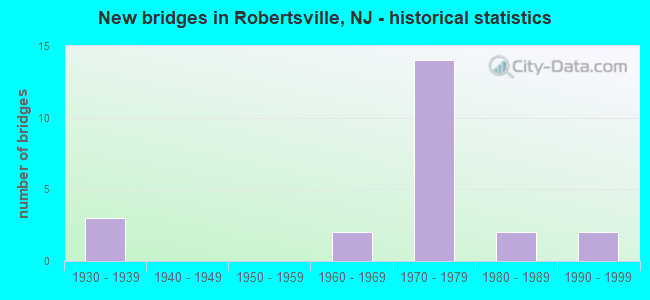
- New bridges - historical statistics
- 31930-1939
- 21960-1969
- 141970-1979
- 21980-1989
- 21990-1999
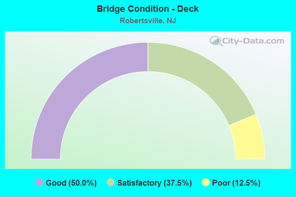
- Bridge Condition - Deck
- 50.0%Good
- 37.5%Satisfactory
- 12.5%Poor
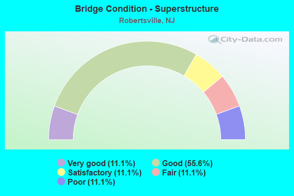
- Bridge Condition - Superstructure
- 11.1%Very good
- 55.6%Good
- 11.1%Satisfactory
- 11.1%Fair
- 11.1%Poor
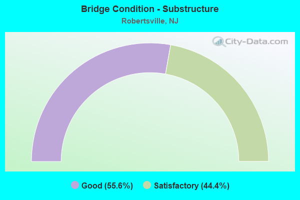
- Bridge Condition - Substructure
- 55.6%Good
- 44.4%Satisfactory
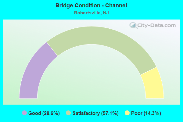
- Bridge Condition - Channel
- 28.6%Good
- 57.1%Satisfactory
- 14.3%Poor
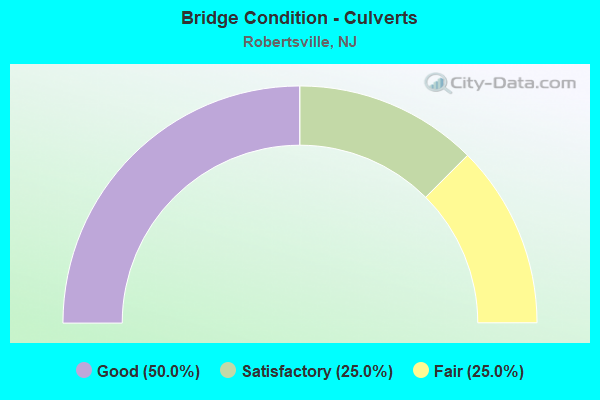
- Bridge Condition - Culverts
- 50.0%Good
- 25.0%Satisfactory
- 25.0%Fair
Find on map >> Show street view
Structure Number: 1211155, Location: 0.8 Mi N. OF CR 690 (Lat: 40.368619, Lng: -74.304389), Route carried "on" structure: Ramp US 9, Year Built: 1972, Status: Open, Structure Length: 4.08m (13.39ft), Average Daily Traffic: 12,730 (year 2020), Truck Traffic: 4%, Average Future Daily Traffic: 15,530 (year 2040), Design Load: HS 20, Features Intersected: US 9 NB & US 9 RAMP 8
Minimum Vertical Clearance: 30+ m (98+ ft), Kilometerpoint: 196.404, Lanes on structure: 1, Lanes under structure: 3, Owner: State Highway Agency, Approaching Roadway Width: 7.0m (23.0ft), Skew: 1 degrees, Material/Design: Steel, Design/Construction: Stringer/Multi-beam, Number Of Spans In Main Unit: 1, Length of Maximum Span: 39.6m (129.9ft), Curb or Sidewalk Widths: Left: 1.1m (3.6ft), Right: 0.8m (2.6ft), Curb-To-Curb Width: 7.0m (23.0ft), Out-to-Out Width: 10.1m (33.1ft)
Condition: Deck: Good, Superstructure: Good, Substructure: Good, Inventory Rating: 71.7 metric tons, Method Used To Determine Inventory Rating: Load Factor (LF), Structural Evaluation: Better than present minimum criteria, Deck Geometry: Equal to present minimum criteria, Underclear: Equal to present minimum criteria, Approach Roadway Alignment: Better than present minimum criteria, Designated Inspection Frequency: Every 24 months, Inspection Date: June 2020, Deck Structure Type: Concrete Cast-file-Place, Wearing Surface/Protective System: Wearing Surface: Monolithic Concrete
Find on map >> Show street view
Structure Number: 1211156, Location: 1.95 MI N OF CO. 520 JCT (Lat: 40.369289, Lng: -74.304431), Route carried "on" structure: State highway 18, Year Built: 1972, Status: Open, Structure Length: 4.27m (14.01ft), Average Daily Traffic: 24,630 (year 2020), Truck Traffic: 4%, Average Future Daily Traffic: 30,050 (year 2040), Design Load: HS 20, Features Intersected: US 9 NB & US 9 RAMP 8
Minimum Vertical Clearance: 30+ m (98+ ft), Kilometerpoint: 48.844, Lanes on structure: 2, Lanes under structure: 3, Base Highway Network: Yes, Owner: State Highway Agency, Approaching Roadway Width: 11.9m (39.0ft), Skew: 3 degrees, Material/Design: Steel, Design/Construction: Stringer/Multi-beam, Number Of Spans In Main Unit: 1, Length of Maximum Span: 41.1m (134.8ft), Curb or Sidewalk Widths: Left: 0.2m (0.7ft), Right: 0.2m (0.7ft), Curb-To-Curb Width: 13.0m (42.7ft), Out-to-Out Width: 14.7m (48.2ft)
Condition: Deck: Good, Superstructure: Good, Substructure: Good, Inventory Rating: 66.2 metric tons, Method Used To Determine Inventory Rating: Load Factor (LF), Structural Evaluation: Better than present minimum criteria, Deck Geometry: Superior to present desirable criteria, Underclear: Equal to present minimum criteria, Approach Roadway Alignment: Equal to present desirable criteria, Designated Inspection Frequency: Every 24 months, Inspection Date: June 2020, Deck Structure Type: Concrete Cast-file-Place, Wearing Surface/Protective System: Wearing Surface: Monolithic Concrete
Find on map >> Show street view
Structure Number: 1211157, Location: RT 18 & US 9 INTERCHANGE (Lat: 40.369400, Lng: -74.303931), Route carried "on" structure: State highway 18, Year Built: 1972, Status: Open, Structure Length: 5.67m (18.60ft), Average Daily Traffic: 24,862 (year 2020), Truck Traffic: 4%, Average Future Daily Traffic: 30,336 (year 2040), Design Load: HS 20, Features Intersected: US 9 NB AND RAMP 8
Minimum Vertical Clearance: 30+ m (98+ ft), Kilometerpoint: 48.844, Lanes on structure: 2, Lanes under structure: 4, Base Highway Network: Yes, Owner: State Highway Agency, Approaching Roadway Width: 12.2m (40.0ft), Skew: 4 degrees, Material/Design: Steel, Design/Construction: Stringer/Multi-beam, Number Of Spans In Main Unit: 2, Length of Maximum Span: 27.7m (90.9ft), Curb or Sidewalk Widths: Left: 0.2m (0.7ft), Right: 0.2m (0.7ft), Curb-To-Curb Width: 13.0m (42.7ft), Out-to-Out Width: 14.7m (48.2ft)
Condition: Deck: Satisfactory, Superstructure: Good, Substructure: Satisfactory, Inventory Rating: 59.9 metric tons, Method Used To Determine Inventory Rating: Load Factor (LF), Structural Evaluation: Equal to present minimum criteria, Deck Geometry: Superior to present desirable criteria, Underclear: Somewhat better than minimum adequacy, Approach Roadway Alignment: Equal to present desirable criteria, Designated Inspection Frequency: Every 24 months, Inspection Date: March 2020, Deck Structure Type: Concrete Cast-file-Place, Wearing Surface/Protective System: Wearing Surface: Monolithic Concrete
Find on map >> Show street view
Structure Number: 1211158, Location: AT 18-9 INTERCHANGE (Lat: 40.370831, Lng: -74.307500), Route carried "on" structure: State highway 18, Year Built: 1972, Status: Open, Structure Length: 4.27m (14.01ft), Average Daily Traffic: 26,218 (year 2020), Truck Traffic: 4%, Average Future Daily Traffic: 31,452 (year 2040), Design Load: HS 20, Features Intersected: US 9 SB
Minimum Vertical Clearance: 30+ m (98+ ft), Kilometerpoint: 49.069, Lanes on structure: 2, Lanes under structure: 3, Base Highway Network: Yes, Owner: State Highway Agency, Approaching Roadway Width: 13.1m (43.0ft), Skew: 4 degrees, Material/Design: Steel, Design/Construction: Stringer/Multi-beam, Number Of Spans In Main Unit: 1, Length of Maximum Span: 41.1m (134.8ft), Curb or Sidewalk Widths: Left: 0.2m (0.7ft), Right: 0.2m (0.7ft), Curb-To-Curb Width: 13.1m (43.0ft), Out-to-Out Width: 14.7m (48.2ft)
Condition: Deck: Satisfactory, Superstructure: Good, Substructure: Satisfactory, Inventory Rating: 64.4 metric tons, Method Used To Determine Inventory Rating: Load Factor (LF), Structural Evaluation: Equal to present minimum criteria, Deck Geometry: Superior to present desirable criteria, Underclear: Equal to present minimum criteria, Approach Roadway Alignment: Equal to present desirable criteria, Designated Inspection Frequency: Every 24 months, Inspection Date: April 2020, Deck Structure Type: Concrete Cast-file-Place, Wearing Surface/Protective System: Wearing Surface: Monolithic Concrete
Find on map >> Show street view
Structure Number: 125B019, Location: 2.5 MI SW JCT RTES 9 & 18 (Lat: 40.348339, Lng: -74.357069), Route carried "on" structure: County highway 527, Year Built: 1996, Status: Open, Structure Length: 0.70m (2.30ft), Average Daily Traffic: 11,804 (year 2021), Truck Traffic: 4%, Average Future Daily Traffic: 14,404 (year 2041), Design Load: HS 20+Mod, Features Intersected: BARCLAYS BROOK, Facility Carried by Structure: ENGLISHTOWN RD
Minimum Vertical Clearance: 30+ m (98+ ft), Kilometerpoint: 54.251, Lanes on structure: 2, Owner: County Highway Agency, Approaching Roadway Width: 10.7m (35.1ft), Skew: 3 degrees, Material/Design: Concrete, Design/Construction: Culvert, Number Of Spans In Main Unit: 1, Length of Maximum Span: 7.0m (23.0ft), Curb or Sidewalk Widths: Left: 1.5m (4.9ft), Right: 1.5m (4.9ft), Curb-To-Curb Width: 12.2m (40.0ft), Out-to-Out Width: 20.1m (65.9ft)
Condition: Channel: Good, Culverts: Good, Operating Rating: 57.2 metric tons, Method Used To Determine Operating Rating: Load Factor (LF), Inventory Rating: 33.6 metric tons, Method Used To Determine Inventory Rating: Load Factor (LF), Structural Evaluation: Better than present minimum criteria, Deck Geometry: Somewhat better than minimum adequacy, Waterway Adequacy: Equal to present desirable criteria, Approach Roadway Alignment: Equal to present desirable criteria, Designated Inspection Frequency: Every 24 months, Inspection Date: April 2021, Deck Structure Type: Concrete Cast-file-Place, Wearing Surface/Protective System: Wearing Surface: Monolithic Concrete, Deck Protection: Epoxy Coated Reinforcing
Find on map >> Show street view
Structure Number: 1300F04, Location: 2.11 miles north of NJ 79 (Lat: 40.294931, Lng: -74.275300), Route carried "on" structure: City street , Year Built: 1985, Status: Open, Structure Length: 0.67m (2.20ft), Average Daily Traffic: 1,560 (year 2021), Truck Traffic: 1%, Average Future Daily Traffic: 1,904 (year 2041), Design Load: HS 20+Mod, Features Intersected: TEPEHEMUS BROOK, Facility Carried by Structure: ROBERTSVILLE ROAD
Minimum Vertical Clearance: 30+ m (98+ ft), Kilometerpoint: 2.398, Lanes on structure: 2, Owner: County Highway Agency, Approaching Roadway Width: 11.6m (38.1ft), Material/Design: Prestressed concrete, Design/Construction: Box Beam or Girders - Multiple, Number Of Spans In Main Unit: 1, Length of Maximum Span: 6.4m (21.0ft), Curb or Sidewalk Widths: Left: 1.5m (4.9ft), Right: 1.5m (4.9ft), Curb-To-Curb Width: 12.2m (40.0ft), Out-to-Out Width: 15.2m (49.9ft)
Condition: Deck: Good, Superstructure: Fair, Substructure: Good, Channel: Satisfactory, Inventory Rating: 56.2 metric tons, Method Used To Determine Inventory Rating: Load Factor (LF), Structural Evaluation: Somewhat better than minimum adequacy, Deck Geometry: Better than present minimum criteria, Waterway Adequacy: Better than present minimum criteria, Approach Roadway Alignment: Equal to present desirable criteria, Designated Inspection Frequency: Every 24 months, Inspection Date: May 2021, Deck Structure Type: Concrete Precast Panels, Wearing Surface/Protective System: Wearing Surface: Bituminous
Find on map >> Show street view
Structure Number: 1303156, Location: 4.2 MI NW OF RT 33&9 CIR (Lat: 40.317661, Lng: -74.305931), Route carried "on" structure: County highway 3, Year Built: 1939, Year Reconstructed: 2010, Status: Open, Structure Length: 3.75m (12.30ft), Average Daily Traffic: 11,485 (year 2020), Truck Traffic: 4%, Average Future Daily Traffic: 13,782 (year 2040), Design Load: HL 93, Features Intersected: US 9
Minimum Vertical Clearance: 30+ m (98+ ft), Kilometerpoint: 5.874, Lanes on structure: 4, Lanes under structure: 5, Owner: State Highway Agency, Approaching Roadway Width: 15.8m (51.8ft), Skew: 4 degrees, Material/Design: Steel, Design/Construction: Stringer/Multi-beam, Number Of Spans In Main Unit: 2, Length of Maximum Span: 17.7m (58.1ft), Curb or Sidewalk Widths: Left: 1.8m (5.9ft), Right: 1.8m (5.9ft), Curb-To-Curb Width: 15.8m (51.8ft), Out-to-Out Width: 20.1m (65.9ft)
Condition: Deck: Good, Superstructure: Very good, Substructure: Satisfactory, Operating Rating: 87.5 metric tons, Method Used To Determine Operating Rating: Load and Resistance Factor Rating (LRFR) rating reported by rating factor(RF) method using HL-93 loadings, Inventory Rating: 64.8 metric tons, Method Used To Determine Inventory Rating: Load and Resistance Factor Rating (LRFR) rating reported by rating factor(RF) method using HL-93 loadings, Structural Evaluation: Equal to present minimum criteria, Deck Geometry: Meets minimum limits, Underclear: Equal to present minimum criteria, Approach Roadway Alignment: Somewhat better than minimum adequacy, Designated Inspection Frequency: Every 24 months, Inspection Date: September 2020, Deck Structure Type: Concrete Precast Panels, Wearing Surface/Protective System: Deck Protection: Epoxy Coated Reinforcing
Find on map >> Show street view
Structure Number: 130ML23, Location: 0.1 MI W OF ROUTE NJ 79 (Lat: 40.333361, Lng: -74.247169), Route carried "on" structure: County highway 520, Year Built: 1973, Status: Open, Structure Length: 0.73m (2.40ft), Average Daily Traffic: 17,740 (year 2021), Truck Traffic: 4%, Average Future Daily Traffic: 21,300 (year 2041), Features Intersected: BIG BROOK
Minimum Vertical Clearance: 30+ m (98+ ft), Kilometerpoint: 10.622, Lanes on structure: 2, Owner: County Highway Agency, Approaching Roadway Width: 8.2m (26.9ft), Skew: 4 degrees, Material/Design: Concrete, Design/Construction: Frame, Number Of Spans In Main Unit: 1, Length of Maximum Span: 6.4m (21.0ft), Curb or Sidewalk Widths: Left: 0.0m, Right: 1.2m (3.9ft), Curb-To-Curb Width: 9.8m (32.2ft), Out-to-Out Width: 18.9m (62.0ft)
Condition: Superstructure: Satisfactory, Substructure: Good, Channel: Satisfactory, Operating Rating: 29.9 metric tons, Method Used To Determine Operating Rating: Load Factor (LF), Inventory Rating: 18.1 metric tons, Method Used To Determine Inventory Rating: Load Factor (LF), Structural Evaluation: Meets minimum limits, Deck Geometry: Meets minimum limits, Waterway Adequacy: Better than present minimum criteria, Approach Roadway Alignment: Equal to present desirable criteria, Designated Inspection Frequency: Every 24 months, Inspection Date: Febuary 2021, Deck Structure Type: Concrete Cast-file-Place, Wearing Surface/Protective System: Wearing Surface: Bituminous
Find on map >> Show street view
Structure Number: 130MN45, Location: 0.3 MILE EAST OF US 9 (Lat: 40.307200, Lng: -74.298000), Route carried "on" structure: City street , Year Built: 1968, Status: Open, Structure Length: 0.76m (2.49ft), Average Daily Traffic: 1,516 (year 2021), Truck Traffic: 3%, Average Future Daily Traffic: 1,850 (year 2041), Design Load: HS 20, Features Intersected: BRANCH OF MILFORD BROOK, Facility Carried by Structure: LAFAYETTE MILLS RD
Minimum Vertical Clearance: 30+ m (98+ ft), Kilometerpoint: 2.334, Lanes on structure: 2, Owner: County Highway Agency, Approaching Roadway Width: 12.2m (40.0ft), Material/Design: Prestressed concrete, Design/Construction: Slab, Number Of Spans In Main Unit: 1, Length of Maximum Span: 6.1m (20.0ft), Curb or Sidewalk Widths: Left: 1.2m (3.9ft), Right: 1.2m (3.9ft), Curb-To-Curb Width: 12.2m (40.0ft), Out-to-Out Width: 14.6m (47.9ft)
Condition: Deck: Poor, Superstructure: Poor, Substructure: Satisfactory, Channel: Satisfactory, Operating Rating: 46.3 metric tons, Method Used To Determine Operating Rating: Field evaluation and documented engineering judgment, Inventory Rating: 27.2 metric tons, Method Used To Determine Inventory Rating: Field evaluation and documented engineering judgment, Structural Evaluation: Meets minimum limits, Deck Geometry: Better than present minimum criteria, Waterway Adequacy: Better than present minimum criteria, Approach Roadway Alignment: Better than present minimum criteria, Length Of Structure Improvement: 1.37m (4.49ft), Designated Inspection Frequency: Every 24 months, Inspection Date: May 2021, Bridge Improvement Cost: $775,000, Roadway Improvement Cost: $48,000, Total Project Cost: $1,321,000 ( Estimate for 2021), Deck Structure Type: Concrete Precast Panels, Wearing Surface/Protective System: Wearing Surface: Bituminous
Find on map >> Show street view
Structure Number: 130MN46, Location: 3.46 miles north of NJ 79 (Lat: 40.311761, Lng: -74.287500), Route carried "on" structure: Other road , Year Built: 1983, Status: Open, Structure Length: 0.61m (2.00ft), Average Daily Traffic: 1,560 (year 2021), Truck Traffic: 1%, Average Future Daily Traffic: 1,904 (year 2041), Design Load: HS 20+Mod, Features Intersected: BRANCH OF MILFORD BROOK, Facility Carried by Structure: ROBERTSVILLE ROAD
Minimum Vertical Clearance: 30+ m (98+ ft), Kilometerpoint: 0.225, Lanes on structure: 2, Owner: County Highway Agency, Approaching Roadway Width: 12.2m (40.0ft), Material/Design: Concrete, Design/Construction: Culvert, Number Of Spans In Main Unit: 1, Length of Maximum Span: 6.1m (20.0ft), Curb or Sidewalk Widths: Left: 1.2m (3.9ft), Right: 1.2m (3.9ft), Curb-To-Curb Width: 12.2m (40.0ft), Out-to-Out Width: 19.4m (63.6ft)
Condition: Channel: Good, Culverts: Good, Operating Rating: 82.6 metric tons, Method Used To Determine Operating Rating: Load Factor (LF), Inventory Rating: 49.0 metric tons, Method Used To Determine Inventory Rating: Load Factor (LF), Structural Evaluation: Better than present minimum criteria, Deck Geometry: Better than present minimum criteria, Waterway Adequacy: Equal to present minimum criteria, Approach Roadway Alignment: Equal to present desirable criteria, Designated Inspection Frequency: Every 24 months, Inspection Date: May 2021, Deck Structure Type: Concrete Cast-file-Place, Wearing Surface/Protective System: Wearing Surface: Bituminous
Find on map >> Show street view
Structure Number: 1322152, Location: 1.1 MI NORTH OF RTE 18 (Lat: 40.323950, Lng: -74.244311), Route carried "on" structure: State highway 79, Year Built: 1938, Status: Open, Structure Length: 0.64m (2.10ft), Average Daily Traffic: 18,212 (year 2020), Truck Traffic: 4%, Average Future Daily Traffic: 21,854 (year 2040), Features Intersected: BIG BROOK
Minimum Vertical Clearance: 30+ m (98+ ft), Kilometerpoint: 9.930, Lanes on structure: 2, Base Highway Network: Yes, Owner: State Highway Agency, Approaching Roadway Width: 12.5m (41.0ft), Skew: 2 degrees, Material/Design: Concrete, Design/Construction: Culvert, Number Of Spans In Main Unit: 1, Length of Maximum Span: 6.4m (21.0ft)
Condition: Channel: Poor, Culverts: Fair, Operating Rating: 89.8 metric tons, Method Used To Determine Operating Rating: Load Factor (LF), Inventory Rating: 89.8 metric tons, Method Used To Determine Inventory Rating: Load Factor (LF), Structural Evaluation: Somewhat better than minimum adequacy, Waterway Adequacy: Superior to present desirable criteria, Approach Roadway Alignment: Equal to present desirable criteria, Designated Inspection Frequency: Every 24 months, Inspection Date: June 2020
Find on map >> Show street view
Structure Number: 1322153, Location: 0.07 MI NORTH OF CR 520 (Lat: 40.334489, Lng: -74.246100), Route carried "on" structure: State highway 79, Year Built: 1992, Status: Open, Structure Length: 0.67m (2.20ft), Average Daily Traffic: 18,212 (year 2020), Truck Traffic: 4%, Average Future Daily Traffic: 21,855 (year 2040), Design Load: HS 20+Mod, Features Intersected: BIG BROOK
Minimum Vertical Clearance: 30+ m (98+ ft), Kilometerpoint: 11.088, Lanes on structure: 2, Base Highway Network: Yes, Owner: State Highway Agency, Approaching Roadway Width: 11.6m (38.1ft), Material/Design: Concrete, Design/Construction: Culvert, Number Of Spans In Main Unit: 2, Length of Maximum Span: 3.0m (9.8ft)
Condition: Channel: Satisfactory, Culverts: Satisfactory, Operating Rating: 89.8 metric tons, Method Used To Determine Operating Rating: Load Factor (LF), Inventory Rating: 89.8 metric tons, Method Used To Determine Inventory Rating: Load Factor (LF), Structural Evaluation: Equal to present minimum criteria, Waterway Adequacy: Superior to present desirable criteria, Approach Roadway Alignment: Equal to present desirable criteria, Designated Inspection Frequency: Every 24 months, Inspection Date: June 2020
Find on map >> Show street view
Structure Number: 1325155, Location: 0.5 MI S OF 18&9 INT (Lat: 40.365681, Lng: -74.298000), Route carried "on" structure: City street , Year Built: 1972, Status: Open, Structure Length: 6.71m (22.01ft), Average Daily Traffic: 5,830 (year 2021), Truck Traffic: 1%, Average Future Daily Traffic: 7,980 (year 2041), Design Load: HS 20, Features Intersected: NJ 18, Facility Carried by Structure: TEXAS ROAD
Minimum Vertical Clearance: 30+ m (98+ ft), Kilometerpoint: 0.338, Lanes on structure: 2, Lanes under structure: 4, Owner: State Highway Agency, Approaching Roadway Width: 12.2m (40.0ft), Skew: 2 degrees, Material/Design: Steel, Design/Construction: Stringer/Multi-beam, Number Of Spans In Main Unit: 2, Length of Maximum Span: 32.9m (107.9ft), Curb or Sidewalk Widths: Left: 0.5m (1.6ft), Right: 1.8m (5.9ft), Curb-To-Curb Width: 9.1m (29.9ft), Out-to-Out Width: 12.8m (42.0ft)
Condition: Deck: Satisfactory, Superstructure: Good, Substructure: Good, Inventory Rating: 59.0 metric tons, Method Used To Determine Inventory Rating: Load Factor (LF), Structural Evaluation: Better than present minimum criteria, Deck Geometry: Meets minimum limits, Underclear: High priority of corrective action, Approach Roadway Alignment: Better than present minimum criteria, Length Of Structure Improvement: 6.70m (21.98ft), Designated Inspection Frequency: Every 24 months, Inspection Date: January 2021, Bridge Improvement Cost: $1,137,000, Roadway Improvement Cost: $114,000, Total Project Cost: $1,700,000 ( Estimate for 2021), Deck Structure Type: Concrete Cast-file-Place, Wearing Surface/Protective System: Wearing Surface: Monolithic Concrete
Find on map >> Show street view
Structure Number: 121115, Location: 5.3 MI N OF RT 79 JCT (Lat: 40.371411, Lng: -74.306239), Route carried "under" structure: US 9, Year Built: 1960, Structure Length: 0. m, Average Daily Traffic: 39,382 (year 2020), Truck Traffic: 4%, Features Intersected: US 9 SB, Facility Carried by Structure: RAMP B
Minimum Vertical Clearance: 4.37m (14.34ft), Kilometerpoint: 196.533, Lanes on structure: 1, Lanes under structure: 3, Material/Design: Steel, Design/Construction: Stringer/Multi-beam, Length of Maximum Span: 24.7m (81.0ft)
Find on map >> Show street view
Structure Number: 1211155, Location: 0.8 Mi N. OF CR 690 (Lat: 40.368619, Lng: -74.304389), Route carried "under" structure: US 9, Year Built: 1972, Structure Length: 0. m, Average Daily Traffic: 31,500 (year 2020), Truck Traffic: 4%, Features Intersected: US 9 NB & US 9 RAMP 8
Minimum Vertical Clearance: 4.65m (15.26ft), Kilometerpoint: 196.388, Lanes on structure: 1, Lanes under structure: 2, Material/Design: Steel, Design/Construction: Stringer/Multi-beam, Length of Maximum Span: 39.6m (129.9ft)
Find on map >> Show street view
Structure Number: 1211155, Location: 0.8 Mi N. OF CR 690 (Lat: 40.368619, Lng: -74.304389), Route carried "under" structure: Ramp US 9, Year Built: 1972, Structure Length: 0. m, Average Daily Traffic: 8,220 (year 2020), Truck Traffic: 4%, Features Intersected: US 9 NB & US 9 RAMP 8
Minimum Vertical Clearance: 4.98m (16.34ft), Kilometerpoint: 196.388, Lanes on structure: 1, Lanes under structure: 1, Material/Design: Steel, Design/Construction: Stringer/Multi-beam, Length of Maximum Span: 39.6m (129.9ft)
Find on map >> Show street view
Structure Number: 1211156, Location: 1.95 MI N OF CO. 520 JCT (Lat: 40.369289, Lng: -74.304431), Route carried "under" structure: US 9, Year Built: 1972, Structure Length: 0. m, Average Daily Traffic: 31,500 (year 2020), Truck Traffic: 4%, Features Intersected: US 9 NB & US 9 RAMP 8, Facility Carried by Structure: NJ 18 SB
Minimum Vertical Clearance: 4.72m (15.49ft), Kilometerpoint: 196.501, Lanes on structure: 2, Lanes under structure: 2, Material/Design: Steel, Design/Construction: Stringer/Multi-beam, Length of Maximum Span: 41.1m (134.8ft)
Find on map >> Show street view
Structure Number: 1211156, Location: 1.95 MI N OF CO. 520 JCT (Lat: 40.369289, Lng: -74.304431), Route carried "under" structure: Ramp US 9, Year Built: 1972, Structure Length: 0. m, Average Daily Traffic: 8,220 (year 2020), Truck Traffic: 4%, Features Intersected: US 9 NB & US 9 RAMP 8, Facility Carried by Structure: NJ 18 SB
Minimum Vertical Clearance: 5.00m (16.40ft), Kilometerpoint: 196.501, Lanes on structure: 2, Lanes under structure: 1, Material/Design: Steel, Design/Construction: Stringer/Multi-beam, Length of Maximum Span: 41.1m (134.8ft)
Find on map >> Show street view
Structure Number: 1211157, Location: RT 18 & US 9 INTERCHANGE (Lat: 40.369400, Lng: -74.303931), Route carried "under" structure: Ramp US 9, Year Built: 1972, Structure Length: 0. m, Average Daily Traffic: 4,734 (year 2020), Truck Traffic: 4%, Features Intersected: US 9 NB AND RAMP 8, Facility Carried by Structure: ROUTE NJ 18 NB
Minimum Vertical Clearance: 4.88m (16.01ft), Kilometerpoint: 196.501, Lanes on structure: 2, Lanes under structure: 1, Material/Design: Steel, Design/Construction: Stringer/Multi-beam, Length of Maximum Span: 27.7m (90.9ft)
Find on map >> Show street view
Structure Number: 1211157, Location: RT 18 & US 9 INTERCHANGE (Lat: 40.369400, Lng: -74.303931), Route carried "under" structure: US 9, Year Built: 1972, Structure Length: 0. m, Average Daily Traffic: 35,030 (year 2020), Truck Traffic: 4%, Features Intersected: US 9 NB AND RAMP 8, Facility Carried by Structure: ROUTE NJ 18 NB
Minimum Vertical Clearance: 5.59m (18.34ft), Kilometerpoint: 196.501, Lanes on structure: 2, Lanes under structure: 3, Material/Design: Steel, Design/Construction: Stringer/Multi-beam, Length of Maximum Span: 27.7m (90.9ft)
Find on map >> Show street view
Structure Number: 1211158, Location: AT 18-9 INTERCHANGE (Lat: 40.370831, Lng: -74.307500), Route carried "under" structure: US 9, Year Built: 1972, Structure Length: 0. m, Average Daily Traffic: 34,750 (year 2020), Truck Traffic: 4%, Features Intersected: US 9 SB, Facility Carried by Structure: 18 SB
Minimum Vertical Clearance: 4.50m (14.76ft), Kilometerpoint: 196.501, Lanes on structure: 2, Lanes under structure: 3, Material/Design: Steel, Design/Construction: Stringer/Multi-beam, Length of Maximum Span: 41.1m (134.8ft)
Find on map >> Show street view
Structure Number: 1303156, Location: 4.2 MI NW OF RT 33&9 CIR (Lat: 40.317661, Lng: -74.305931), Route carried "under" structure: US 9, Year Built: 1939, Structure Length: 0. m, Average Daily Traffic: 62,625 (year 2020), Truck Traffic: 4%, Features Intersected: US 9, Facility Carried by Structure: CR 3
Minimum Vertical Clearance: 4.75m (15.58ft), Kilometerpoint: 190.756, Lanes on structure: 4, Lanes under structure: 5, Material/Design: Steel, Design/Construction: Stringer/Multi-beam, Length of Maximum Span: 17.7m (58.1ft)
Find on map >> Show street view
Structure Number: 1325155, Location: 0.5 MI S OF 18&9 INT (Lat: 40.365681, Lng: -74.298000), Route carried "under" structure: State highway 18, Year Built: 1972, Structure Length: 0. m, Average Daily Traffic: 40,800 (year 2019), Truck Traffic: 5%, Features Intersected: NJ 18, Facility Carried by Structure: TEXAS ROAD
Minimum Vertical Clearance: 4.62m (15.16ft), Kilometerpoint: 48.135, Lanes on structure: 2, Lanes under structure: 4, Material/Design: Steel, Design/Construction: Stringer/Multi-beam, Length of Maximum Span: 32.9m (107.9ft)