Bridge Statistics for Roby, Texas (TX)
Condition, Traffic, Stress, Structural Evaluation, Project Costs
- National Bridge Inventory (NBI) Statistics
- 19Number of bridges
- 135ft / 40.7mTotal length
- $435,000Total costs
- 13,718Total average daily traffic
- 3,226Total average daily truck traffic
- 18,300Total future (year 2028) average daily traffic
- National Bridge Inventory (NBI) Registered Bridges for Roby
- No street view available for this location
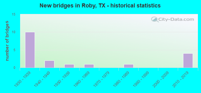
- New bridges - historical statistics
- 101930-1939
- 21940-1949
- 11950-1959
- 11960-1969
- 11980-1989
- 42010-2019

- Reconstructed bridges - Historical Statistics
- 11940-1949
- 51950-1959
- 21960-1969
- 11970-1979


- Bridge Condition - Deck
- 50.0%Good
- 42.9%Fair
- 7.1%Poor

- Bridge Condition - Superstructure
- 28.6%Very good
- 7.1%Good
- 35.7%Satisfactory
- 28.6%Fair

- Bridge Condition - Substructure
- 21.4%Very good
- 7.1%Good
- 35.7%Satisfactory
- 35.7%Fair

- Bridge Condition - Channel
- 36.8%Good
- 57.9%Satisfactory
- 5.3%Fair

- Bridge Condition - Culverts
- 40.0%Good
- 60.0%Satisfactory
Find on map >> Show street view
Structure Number: 80770026303004, Location: 2.98 MI S OF KENT CO LN (Lat: 32.939733, Lng: -100.489100), Route carried "on" structure: State highway 70, Year Built: 1933, Status: Open, Structure Length: 0.70m (2.30ft), Average Daily Traffic: 816 (year 2020), Truck Traffic: 30%, Average Future Daily Traffic: 1,130 (year 2033), Features Intersected: DRAW
Minimum Vertical Clearance: 30+ m (98+ ft), Kilometerpoint: 6.413, Lanes on structure: 2, Base Highway Network: Yes, Owner: State Highway Agency, Approaching Roadway Width: 12.8m (42.0ft), Material/Design: Concrete, Design/Construction: Culvert, Number Of Spans In Main Unit: 2, Length of Maximum Span: 3.0m (9.8ft)
Condition: Channel: Satisfactory, Culverts: Satisfactory, Operating Rating: 32.7 metric tons, Method Used To Determine Operating Rating: Field evaluation and documented engineering judgment, Inventory Rating: 24.5 metric tons, Method Used To Determine Inventory Rating: Field evaluation and documented engineering judgment, Structural Evaluation: Equal to present minimum criteria, Waterway Adequacy: Equal to present minimum criteria, Approach Roadway Alignment: Equal to present minimum criteria, Designated Inspection Frequency: Every 24 months, Inspection Date: July 2021
Find on map >> Show street view
Structure Number: 80770026304009, Location: 6.40 MI SE OF SH 92 (Lat: 32.787486, Lng: -100.388889), Route carried "on" structure: State highway 70, Year Built: 1932, Year Reconstructed: 1961, Status: Open, Structure Length: 7.83m (25.69ft), Average Daily Traffic: 1,429 (year 2020), Truck Traffic: 30%, Average Future Daily Traffic: 1,820 (year 2033), Design Load: H 15, Features Intersected: CLEAR FORK OF BRAZOS RIV
Minimum Vertical Clearance: 30+ m (98+ ft), Kilometerpoint: 11.228, Lanes on structure: 2, Owner: State Highway Agency, Approaching Roadway Width: 12.8m (42.0ft), Material/Design: Concrete, Design/Construction: Tee Beam, Number Of Spans In Main Unit: 9, Length of Maximum Span: 8.8m (28.9ft), Curb-To-Curb Width: 12.6m (41.3ft), Out-to-Out Width: 13.4m (44.0ft)
Condition: Deck: Fair, Superstructure: Fair, Substructure: Satisfactory, Channel: Satisfactory, Operating Rating: 59.0 metric tons, Method Used To Determine Operating Rating: Load Factor (LF), Inventory Rating: 35.4 metric tons, Method Used To Determine Inventory Rating: Load Factor (LF), Structural Evaluation: Somewhat better than minimum adequacy, Deck Geometry: Better than present minimum criteria, Waterway Adequacy: Equal to present minimum criteria, Approach Roadway Alignment: Equal to present desirable criteria, Designated Inspection Frequency: Every 24 months, Inspection Date: July 2021, Deck Structure Type: Concrete Cast-file-Place, Wearing Surface/Protective System: Wearing Surface: Bituminous
Find on map >> Show street view
Structure Number: 8077002630401, Location: 7.20 MI S OF SH 92 (Lat: 32.776425, Lng: -100.385486), Route carried "on" structure: State highway 70, Year Built: 1932, Year Reconstructed: 1961, Status: Open, Structure Length: 3.47m (11.38ft), Average Daily Traffic: 1,429 (year 2020), Truck Traffic: 30%, Average Future Daily Traffic: 1,820 (year 2033), Design Load: H 15, Features Intersected: ALKALI CREEK
Minimum Vertical Clearance: 30+ m (98+ ft), Kilometerpoint: 12.563, Lanes on structure: 2, Owner: State Highway Agency, Approaching Roadway Width: 12.8m (42.0ft), Material/Design: Concrete, Design/Construction: Tee Beam, Number Of Spans In Main Unit: 4, Length of Maximum Span: 8.8m (28.9ft), Curb-To-Curb Width: 12.6m (41.3ft), Out-to-Out Width: 13.4m (44.0ft)
Condition: Deck: Fair, Superstructure: Fair, Substructure: Fair, Channel: Satisfactory, Operating Rating: 59.0 metric tons, Method Used To Determine Operating Rating: Load Factor (LF), Inventory Rating: 35.4 metric tons, Method Used To Determine Inventory Rating: Load Factor (LF), Structural Evaluation: Somewhat better than minimum adequacy, Deck Geometry: Better than present minimum criteria, Waterway Adequacy: Equal to present minimum criteria, Approach Roadway Alignment: Equal to present desirable criteria, Designated Inspection Frequency: Every 24 months, Inspection Date: July 2021, Deck Structure Type: Concrete Cast-file-Place, Wearing Surface/Protective System: Wearing Surface: Bituminous
Find on map >> Show street view
Structure Number: 80770026305011, Location: 1.10 MI S OF US 180 (Lat: 32.729569, Lng: -100.373844), Route carried "on" structure: State highway 70, Year Built: 1931, Year Reconstructed: 1961, Status: Open, Structure Length: 5.21m (17.09ft), Average Daily Traffic: 1,597 (year 2020), Truck Traffic: 30%, Average Future Daily Traffic: 2,390 (year 2033), Features Intersected: COTTONWOOD CREEK
Minimum Vertical Clearance: 30+ m (98+ ft), Kilometerpoint: 2.343, Lanes on structure: 2, Owner: State Highway Agency, Approaching Roadway Width: 12.2m (40.0ft), Material/Design: Concrete, Design/Construction: Tee Beam, Number Of Spans In Main Unit: 6, Length of Maximum Span: 8.8m (28.9ft), Curb-To-Curb Width: 12.7m (41.7ft), Out-to-Out Width: 13.4m (44.0ft)
Condition: Deck: Good, Superstructure: Good, Substructure: Satisfactory, Channel: Good, Operating Rating: 59.0 metric tons, Method Used To Determine Operating Rating: Load Factor (LF), Inventory Rating: 35.4 metric tons, Method Used To Determine Inventory Rating: Load Factor (LF), Structural Evaluation: Equal to present minimum criteria, Deck Geometry: Better than present minimum criteria, Waterway Adequacy: Equal to present minimum criteria, Approach Roadway Alignment: Equal to present desirable criteria, Length Of Structure Improvement: 5.12m (16.80ft), Designated Inspection Frequency: Every 24 months, Inspection Date: July 2021, Bridge Improvement Cost: $141,000, Roadway Improvement Cost: $35,000, Total Project Cost: $212,000, Deck Structure Type: Concrete Cast-file-Place, Wearing Surface/Protective System: Wearing Surface: Bituminous
Find on map >> Show street view
Structure Number: 80770026305012, Location: 3.30 MI S OF US 180 (Lat: 32.697319, Lng: -100.374219), Route carried "on" structure: State highway 70, Year Built: 1931, Year Reconstructed: 1968, Status: Open, Structure Length: 0.70m (2.30ft), Average Daily Traffic: 1,504 (year 2020), Truck Traffic: 30%, Average Future Daily Traffic: 1,880 (year 2033), Design Load: H 15, Features Intersected: SANDY CREEK
Minimum Vertical Clearance: 30+ m (98+ ft), Kilometerpoint: 5.945, Lanes on structure: 2, Owner: State Highway Agency, Approaching Roadway Width: 12.8m (42.0ft), Material/Design: Concrete, Design/Construction: Culvert, Number Of Spans In Main Unit: 2, Length of Maximum Span: 3.0m (9.8ft), Curb-To-Curb Width: 15.9m (52.2ft), Out-to-Out Width: 16.2m (53.1ft)
Condition: Channel: Fair, Culverts: Good, Operating Rating: 39.9 metric tons, Method Used To Determine Operating Rating: Load Factor (LF), Inventory Rating: 23.6 metric tons, Method Used To Determine Inventory Rating: Load Factor (LF), Structural Evaluation: Equal to present minimum criteria, Deck Geometry: Superior to present desirable criteria, Waterway Adequacy: Equal to present minimum criteria, Approach Roadway Alignment: Equal to present desirable criteria, Designated Inspection Frequency: Every 24 months, Inspection Date: July 2021, Deck Structure Type: Concrete Cast-file-Place, Wearing Surface/Protective System: Wearing Surface: Bituminous
Find on map >> Show street view
Structure Number: 80770026305019, Location: 0.30 MI S OF US 180 (Lat: 32.740675, Lng: -100.376475), Route carried "on" structure: State highway 70, Year Built: 1968, Status: Open, Structure Length: 0.73m (2.40ft), Average Daily Traffic: 1,597 (year 2020), Truck Traffic: 30%, Average Future Daily Traffic: 2,390 (year 2033), Design Load: HS 20, Features Intersected: DRAIN
Minimum Vertical Clearance: 30+ m (98+ ft), Kilometerpoint: 1.094, Lanes on structure: 4, Owner: State Highway Agency, Approaching Roadway Width: 19.5m (64.0ft), Skew: 4 degrees, Material/Design: Concrete, Design/Construction: Culvert, Number Of Spans In Main Unit: 3, Length of Maximum Span: 1.5m (4.9ft), Curb-To-Curb Width: 19.5m (64.0ft), Out-to-Out Width: 24.2m (79.4ft)
Condition: Channel: Satisfactory, Culverts: Good, Operating Rating: 39.9 metric tons, Method Used To Determine Operating Rating: Load Factor (LF), Inventory Rating: 23.6 metric tons, Method Used To Determine Inventory Rating: Load Factor (LF), Structural Evaluation: Equal to present minimum criteria, Deck Geometry: Better than present minimum criteria, Waterway Adequacy: Equal to present minimum criteria, Approach Roadway Alignment: Equal to present desirable criteria, Designated Inspection Frequency: Every 24 months, Inspection Date: July 2021, Deck Structure Type: Concrete Cast-file-Place, Wearing Surface/Protective System: Wearing Surface: Bituminous
Find on map >> Show street view
Structure Number: 8077002960201, Location: 2.95 MI W OF SH 70 (Lat: 32.742178, Lng: -100.428983), Route carried "on" structure: US 180, Year Built: 1931, Year Reconstructed: 1940, Status: Open, Structure Length: 3.60m (11.81ft), Average Daily Traffic: 1,330 (year 2013), Truck Traffic: 12%, Average Future Daily Traffic: 1,860 (year 2033), Design Load: H 15, Features Intersected: DRAW
Minimum Vertical Clearance: 30+ m (98+ ft), Kilometerpoint: 23.163, Lanes on structure: 2, Base Highway Network: Yes, Owner: State Highway Agency, Approaching Roadway Width: 12.8m (42.0ft), Material/Design: Concrete, Design/Construction: Culvert, Number Of Spans In Main Unit: 21, Length of Maximum Span: 1.5m (4.9ft), Curb-To-Curb Width: 12.5m (41.0ft), Out-to-Out Width: 13.2m (43.3ft)
Condition: Channel: Satisfactory, Culverts: Satisfactory, Operating Rating: 39.9 metric tons, Method Used To Determine Operating Rating: Load Factor (LF), Inventory Rating: 23.6 metric tons, Method Used To Determine Inventory Rating: Load Factor (LF), Structural Evaluation: Equal to present minimum criteria, Deck Geometry: Better than present minimum criteria, Waterway Adequacy: Equal to present minimum criteria, Approach Roadway Alignment: Equal to present desirable criteria, Designated Inspection Frequency: Every 24 months, Inspection Date: July 2021, Deck Structure Type: Concrete Cast-file-Place, Wearing Surface/Protective System: Wearing Surface: Bituminous
Find on map >> Show street view
Structure Number: 80770029602011, Location: 2.45 MI W OF SH 70 (Lat: 32.742375, Lng: -100.419978), Route carried "on" structure: US 180, Year Built: 1931, Year Reconstructed: 1955, Status: Open, Structure Length: 1.62m (5.31ft), Average Daily Traffic: 1,330 (year 2013), Truck Traffic: 12%, Average Future Daily Traffic: 1,860 (year 2033), Design Load: H 15, Features Intersected: DRAW
Minimum Vertical Clearance: 30+ m (98+ ft), Kilometerpoint: 24.011, Lanes on structure: 2, Base Highway Network: Yes, Owner: State Highway Agency, Approaching Roadway Width: 12.8m (42.0ft), Material/Design: Concrete, Design/Construction: Culvert, Number Of Spans In Main Unit: 8, Length of Maximum Span: 1.8m (5.9ft), Curb-To-Curb Width: 13.4m (44.0ft), Out-to-Out Width: 13.8m (45.3ft)
Condition: Channel: Good, Culverts: Satisfactory, Operating Rating: 39.9 metric tons, Method Used To Determine Operating Rating: Load Factor (LF), Inventory Rating: 23.6 metric tons, Method Used To Determine Inventory Rating: Load Factor (LF), Structural Evaluation: Equal to present minimum criteria, Deck Geometry: Equal to present desirable criteria, Waterway Adequacy: Equal to present minimum criteria, Approach Roadway Alignment: Equal to present desirable criteria, Designated Inspection Frequency: Every 24 months, Inspection Date: July 2021, Deck Structure Type: Concrete Cast-file-Place, Wearing Surface/Protective System: Wearing Surface: Bituminous
Find on map >> Show street view
Structure Number: 80770029603012, Location: 0.80 MI E OF SH 70 (Lat: 32.747881, Lng: -100.363778), Route carried "on" structure: US 180, Year Built: 1930, Year Reconstructed: 1968, Status: Open, Structure Length: 5.58m (18.31ft), Average Daily Traffic: 1,666 (year 2020), Truck Traffic: 24%, Average Future Daily Traffic: 2,450 (year 2033), Features Intersected: COTTONWOOD CREEK
Minimum Vertical Clearance: 30+ m (98+ ft), Kilometerpoint: 1.326, Lanes on structure: 2, Base Highway Network: Yes, Owner: State Highway Agency, Approaching Roadway Width: 12.8m (42.0ft), Material/Design: Concrete, Design/Construction: Tee Beam, Number Of Spans In Main Unit: 5, Length of Maximum Span: 11.3m (37.1ft), Curb-To-Curb Width: 13.4m (44.0ft), Out-to-Out Width: 14.1m (46.3ft)
Condition: Deck: Good, Superstructure: Fair, Substructure: Fair, Channel: Satisfactory, Operating Rating: 54.4 metric tons, Method Used To Determine Operating Rating: Load Factor (LF), Inventory Rating: 32.7 metric tons, Method Used To Determine Inventory Rating: Load Factor (LF), Structural Evaluation: Somewhat better than minimum adequacy, Deck Geometry: Equal to present desirable criteria, Waterway Adequacy: Equal to present minimum criteria, Approach Roadway Alignment: Equal to present desirable criteria, Designated Inspection Frequency: Every 24 months, Inspection Date: July 2021, Deck Structure Type: Concrete Cast-file-Place, Wearing Surface/Protective System: Wearing Surface: Bituminous
Find on map >> Show street view
Structure Number: 80770AA0119001, Location: 1.2 MI E OF SH 70 (Lat: 32.764972, Lng: -100.399111), Route carried "on" structure: County highway 303, Year Built: 2015, Status: Open, Structure Length: 1.22m (4.00ft), Average Daily Traffic: 100 (year 2015), Average Future Daily Traffic: 100 (year 2035), Design Load: HL 93, Features Intersected: ALKALI CREEK
Minimum Vertical Clearance: 30+ m (98+ ft), Kilometerpoint: 1.931, Lanes on structure: 2, Owner: County Highway Agency, Approaching Roadway Width: 4.9m (16.1ft), Material/Design: Prestressed concrete, Number Of Spans In Main Unit: 1, Length of Maximum Span: 12.2m (40.0ft), Curb-To-Curb Width: 7.3m (24.0ft), Out-to-Out Width: 7.9m (25.9ft)
Condition: Deck: Good, Superstructure: Very good, Substructure: Very good, Channel: Good, Operating Rating: 54.4 metric tons, Method Used To Determine Operating Rating: Assigned ratings based on Load and Resistance Factor Design (LRFD) reported in metric tons, Inventory Rating: 32.7 metric tons, Method Used To Determine Inventory Rating: Assigned ratings based on Load and Resistance Factor Design (LRFD) reported in metric tons, Structural Evaluation: Equal to present desirable criteria, Deck Geometry: Equal to present minimum criteria, Waterway Adequacy: Meets minimum limits, Approach Roadway Alignment: Equal to present desirable criteria, Designated Inspection Frequency: Every 24 months, Inspection Date: May 2020, Bridge Improvement Cost: $3,000, Roadway Improvement Cost: $1,000, Total Project Cost: $4,000, Deck Structure Type: Concrete Cast-file-Place
Find on map >> Show street view
Structure Number: 80770AA0120001, Location: 1.9 MI N OF US 180 (Lat: 32.767625, Lng: -100.415781), Route carried "on" structure: County highway 305, Year Built: 1943, Status: Posted for load, Structure Length: 1.40m (4.59ft), Average Daily Traffic: 100 (year 2015), Average Future Daily Traffic: 50 (year 2035), Features Intersected: ALKALI CREEK
Minimum Vertical Clearance: 30+ m (98+ ft), Kilometerpoint: 4.506, Lanes on structure: 1, Owner: Town or Township Highway Agency, Approaching Roadway Width: 5.5m (18.0ft), Material/Design: Steel, Design/Construction: Stringer/Multi-beam, Number Of Spans In Main Unit: 1, Number Of Approach Spans: 1, Length of Maximum Span: 8.8m (28.9ft), Curb-To-Curb Width: 6.1m (20.0ft), Out-to-Out Width: 6.7m (22.0ft)
Condition: Deck: Fair, Superstructure: Satisfactory, Substructure: Fair, Channel: Satisfactory, Operating Rating: 26.3 metric tons, Method Used To Determine Operating Rating: Allowable Stress (AS), Inventory Rating: 17.2 metric tons, Method Used To Determine Inventory Rating: Allowable Stress (AS), Structural Evaluation: Somewhat better than minimum adequacy, Deck Geometry: Somewhat better than minimum adequacy, Waterway Adequacy: Meets minimum limits, Approach Roadway Alignment: Equal to present desirable criteria, Bridge Posting: Required (Relationship of Operating Rating to Maximum Legal Load: 20.0 - 29.9% below), Length Of Structure Improvement: 1.40m (4.59ft), Designated Inspection Frequency: Every 24 months, Inspection Date: May 2020, Total Project Cost: $13,000, Deck Structure Type: Concrete Cast-file-Place
Find on map >> Show street view
Structure Number: 80770AA0120002, Location: 0.7 MI N OF US 180 (Lat: 32.750958, Lng: -100.411069), Route carried "on" structure: County highway 305, Year Built: 1945, Status: Posted for load, Structure Length: 0.91m (2.99ft), Average Daily Traffic: 100 (year 2010), Average Future Daily Traffic: 50 (year 2028), Features Intersected: ALKALI CRK TRIB
Minimum Vertical Clearance: 30+ m (98+ ft), Kilometerpoint: 6.437, Lanes on structure: 1, Owner: Town or Township Highway Agency, Approaching Roadway Width: 6.7m (22.0ft), Material/Design: Steel, Design/Construction: Stringer/Multi-beam, Number Of Spans In Main Unit: 1, Length of Maximum Span: 8.8m (28.9ft), Curb-To-Curb Width: 6.1m (20.0ft), Out-to-Out Width: 6.7m (22.0ft)
Condition: Deck: Poor, Superstructure: Fair, Substructure: Satisfactory, Channel: Satisfactory, Operating Rating: 32.7 metric tons, Method Used To Determine Operating Rating: Field evaluation and documented engineering judgment, Inventory Rating: 24.5 metric tons, Method Used To Determine Inventory Rating: Field evaluation and documented engineering judgment, Structural Evaluation: Somewhat better than minimum adequacy, Deck Geometry: Somewhat better than minimum adequacy, Waterway Adequacy: Meets minimum limits, Approach Roadway Alignment: Equal to present desirable criteria, Bridge Posting: Required (Relationship of Operating Rating to Maximum Legal Load: > 39.9% below), Length Of Structure Improvement: 0.91m (2.99ft), Designated Inspection Frequency: Every 24 months, Inspection Date: May 2020, Bridge Improvement Cost: $12,000, Roadway Improvement Cost: $3,000, Total Project Cost: $15,000, Deck Structure Type: Concrete Cast-file-Place, Wearing Surface/Protective System: Wearing Surface: Gravel
Find on map >> Show street view
Structure Number: 80770AA0122002, Location: 1.4 MI N OF US 180 (Lat: 32.762347, Lng: -100.427025), Route carried "on" structure: County highway 309, Year Built: 2013, Status: Open, Structure Length: 1.22m (4.00ft), Average Daily Traffic: 100 (year 2015), Average Future Daily Traffic: 50 (year 2035), Design Load: HL 93, Features Intersected: ALKALI CREEK
Minimum Vertical Clearance: 30+ m (98+ ft), Kilometerpoint: 8.369, Lanes on structure: 2, Owner: Town or Township Highway Agency, Approaching Roadway Width: 5.5m (18.0ft), Material/Design: Prestressed concrete, Number Of Spans In Main Unit: 1, Length of Maximum Span: 12.2m (40.0ft), Curb-To-Curb Width: 7.1m (23.3ft), Out-to-Out Width: 7.9m (25.9ft)
Condition: Deck: Good, Superstructure: Very good, Substructure: Very good, Channel: Good, Operating Rating: 54.4 metric tons, Method Used To Determine Operating Rating: Assigned ratings based on Load and Resistance Factor Design (LRFD) reported in metric tons, Inventory Rating: 32.7 metric tons, Method Used To Determine Inventory Rating: Assigned ratings based on Load and Resistance Factor Design (LRFD) reported in metric tons, Structural Evaluation: Equal to present desirable criteria, Deck Geometry: Somewhat better than minimum adequacy, Waterway Adequacy: Meets minimum limits, Approach Roadway Alignment: Equal to present desirable criteria, Length Of Structure Improvement: 1.62m (5.31ft), Designated Inspection Frequency: Every 24 months, Inspection Date: May 2020, Bridge Improvement Cost: $3,000, Roadway Improvement Cost: $1,000, Total Project Cost: $4,000, Deck Structure Type: Concrete Cast-file-Place
Find on map >> Show street view
Structure Number: 80770AA0130001, Location: 0.6 MI W OF SH 70 (Lat: 32.800322, Lng: -100.407386), Route carried "on" structure: County highway 307, Year Built: 1988, Status: Open, Structure Length: 1.19m (3.90ft), Average Daily Traffic: 100 (year 2015), Average Future Daily Traffic: 50 (year 2035), Features Intersected: CLEAR FK BRAZOS RI TRIB
Minimum Vertical Clearance: 30+ m (98+ ft), Kilometerpoint: 0.966, Lanes on structure: 1, Owner: Town or Township Highway Agency, Approaching Roadway Width: 5.5m (18.0ft), Material/Design: Steel continuous, Number Of Spans In Main Unit: 2, Length of Maximum Span: 5.8m (19.0ft), Curb-To-Curb Width: 4.1m (13.5ft), Out-to-Out Width: 4.1m (13.5ft)
Condition: Deck: Good, Superstructure: Satisfactory, Substructure: Fair, Channel: Satisfactory, Operating Rating: 32.7 metric tons, Method Used To Determine Operating Rating: Field evaluation and documented engineering judgment, Inventory Rating: 24.5 metric tons, Method Used To Determine Inventory Rating: Field evaluation and documented engineering judgment, Structural Evaluation: Somewhat better than minimum adequacy, Deck Geometry: Somewhat better than minimum adequacy, Waterway Adequacy: Meets minimum limits, Approach Roadway Alignment: Equal to present desirable criteria, Length Of Structure Improvement: 1.95m (6.40ft), Designated Inspection Frequency: Every 24 months, Inspection Date: May 2020, Bridge Improvement Cost: $140,000, Roadway Improvement Cost: $32,000, Total Project Cost: $172,000, Deck Structure Type: Concrete Cast-file-Place
Find on map >> Show street view
Structure Number: 80770AA0134001, Location: 0.2 MI E OF SH 70 (Lat: 32.736861, Lng: -100.372817), Route carried "on" structure: County highway 104, Year Built: 1950, Status: Open, Structure Length: 0.91m (2.99ft), Average Daily Traffic: 120 (year 2015), Average Future Daily Traffic: 70 (year 2035), Features Intersected: COTTONWOOD CREEK
Minimum Vertical Clearance: 30+ m (98+ ft), Kilometerpoint: 0.241, Lanes on structure: 1, Owner: Town or Township Highway Agency, Approaching Roadway Width: 5.5m (18.0ft), Material/Design: Steel, Design/Construction: Stringer/Multi-beam, Number Of Spans In Main Unit: 1, Length of Maximum Span: 9.1m (29.9ft), Curb-To-Curb Width: 3.7m (12.1ft), Out-to-Out Width: 4.1m (13.5ft)
Condition: Deck: Fair, Superstructure: Satisfactory, Substructure: Satisfactory, Channel: Satisfactory, Operating Rating: 42.6 metric tons, Method Used To Determine Operating Rating: Allowable Stress (AS), Inventory Rating: 28.1 metric tons, Method Used To Determine Inventory Rating: Allowable Stress (AS), Structural Evaluation: Equal to present minimum criteria, Deck Geometry: High priority of replacement, Waterway Adequacy: Equal to present minimum criteria, Approach Roadway Alignment: Equal to present desirable criteria, Length Of Structure Improvement: 0.91m (2.99ft), Designated Inspection Frequency: Every 24 months, Inspection Date: May 2020, Bridge Improvement Cost: $1,000, Total Project Cost: $1,000, Deck Structure Type: Concrete Cast-file-Place
Find on map >> Show street view
Structure Number: 80770AA0135001, Location: 1.1 MI E OF SH 70 (Lat: 32.762064, Lng: -100.364239), Route carried "on" structure: County highway 204, Year Built: 2013, Status: Open, Structure Length: 0.76m (2.49ft), Average Daily Traffic: 90 (year 2016), Average Future Daily Traffic: 90 (year 2033), Design Load: HL 93, Features Intersected: COTTONWOOD CREEK
Minimum Vertical Clearance: 30+ m (98+ ft), Kilometerpoint: 2.253, Lanes on structure: 2, Owner: Town or Township Highway Agency, Approaching Roadway Width: 5.5m (18.0ft), Material/Design: Prestressed concrete, Number Of Spans In Main Unit: 1, Length of Maximum Span: 7.6m (24.9ft), Curb-To-Curb Width: 7.1m (23.3ft), Out-to-Out Width: 7.9m (25.9ft)
Condition: Deck: Good, Superstructure: Very good, Substructure: Good, Channel: Good, Operating Rating: 54.4 metric tons, Method Used To Determine Operating Rating: Assigned ratings based on Load and Resistance Factor Design (LRFD) reported in metric tons, Inventory Rating: 32.7 metric tons, Method Used To Determine Inventory Rating: Assigned ratings based on Load and Resistance Factor Design (LRFD) reported in metric tons, Structural Evaluation: Better than present minimum criteria, Deck Geometry: Somewhat better than minimum adequacy, Waterway Adequacy: Meets minimum limits, Approach Roadway Alignment: Equal to present desirable criteria, Length Of Structure Improvement: 1.43m (4.69ft), Designated Inspection Frequency: Every 24 months, Inspection Date: May 2020, Bridge Improvement Cost: $3,000, Roadway Improvement Cost: $1,000, Total Project Cost: $4,000, Deck Structure Type: Concrete Cast-file-Place
Find on map >> Show street view
Structure Number: 80770AA0136001, Location: 0.8 MI E OF SH 70 (Lat: 32.753767, Lng: -100.366056), Route carried "on" structure: County highway 202, Year Built: 2011, Status: Open, Structure Length: 1.22m (4.00ft), Average Daily Traffic: 110 (year 2016), Average Future Daily Traffic: 110 (year 2033), Design Load: HL 93, Features Intersected: COTTONWOOD CREEK
Minimum Vertical Clearance: 30+ m (98+ ft), Kilometerpoint: 1.287, Lanes on structure: 2, Owner: Town or Township Highway Agency, Approaching Roadway Width: 4.6m (15.1ft), Material/Design: Prestressed concrete, Number Of Spans In Main Unit: 1, Length of Maximum Span: 12.2m (40.0ft), Curb-To-Curb Width: 7.1m (23.3ft), Out-to-Out Width: 7.9m (25.9ft)
Condition: Deck: Good, Superstructure: Very good, Substructure: Very good, Channel: Good, Operating Rating: 54.4 metric tons, Method Used To Determine Operating Rating: Assigned ratings based on Load and Resistance Factor Design (LRFD) reported in metric tons, Inventory Rating: 32.7 metric tons, Method Used To Determine Inventory Rating: Assigned ratings based on Load and Resistance Factor Design (LRFD) reported in metric tons, Structural Evaluation: Equal to present desirable criteria, Deck Geometry: Meets minimum limits, Waterway Adequacy: Meets minimum limits, Approach Roadway Alignment: Equal to present desirable criteria, Length Of Structure Improvement: 1.62m (5.31ft), Designated Inspection Frequency: Every 24 months, Inspection Date: May 2020, Bridge Improvement Cost: $3,000, Roadway Improvement Cost: $1,000, Total Project Cost: $4,000, Deck Structure Type: Concrete Precast Panels
Find on map >> Show street view
Structure Number: 80770AA0154001, Location: 2.1 MI E OF SH 70 (Lat: 32.730894, Lng: -100.338575), Route carried "on" structure: County highway 106, Year Built: 1933, Year Reconstructed: 1950, Status: Posted for load, Structure Length: 1.22m (4.00ft), Average Daily Traffic: 100 (year 2016), Average Future Daily Traffic: 80 (year 2033), Features Intersected: SANDY CREEK
Minimum Vertical Clearance: 30+ m (98+ ft), Kilometerpoint: 3.058, Lanes on structure: 1, Owner: Town or Township Highway Agency, Approaching Roadway Width: 5.5m (18.0ft), Material/Design: Steel, Design/Construction: Stringer/Multi-beam, Number Of Spans In Main Unit: 1, Length of Maximum Span: 11.9m (39.0ft), Curb-To-Curb Width: 4.9m (16.1ft), Out-to-Out Width: 4.9m (16.1ft)
Condition: Deck: Fair, Superstructure: Satisfactory, Substructure: Satisfactory, Channel: Good, Operating Rating: 20.9 metric tons, Method Used To Determine Operating Rating: Allowable Stress (AS), Inventory Rating: 11.8 metric tons, Method Used To Determine Inventory Rating: Allowable Stress (AS), Structural Evaluation: Meets minimum limits, Deck Geometry: High priority of corrective action, Waterway Adequacy: Meets minimum limits, Approach Roadway Alignment: Better than present minimum criteria, Bridge Posting: Required (Relationship of Operating Rating to Maximum Legal Load: 30.0 - 39.9% below), Length Of Structure Improvement: 1.95m (6.40ft), Designated Inspection Frequency: Every 24 months, Inspection Date: May 2020, Bridge Improvement Cost: $4,000, Roadway Improvement Cost: $1,000, Total Project Cost: $5,000, Deck Structure Type: Concrete Cast-file-Place, Wearing Surface/Protective System: Wearing Surface: Gravel
Find on map >> Show street view
Structure Number: 80770AA0255001, Location: 0.5 MI N OF CR 106 (Lat: 32.741353, Lng: -100.324122), Route carried "on" structure: County highway 109, Year Built: 1933, Year Reconstructed: 1970, Status: Posted for load, Structure Length: 1.22m (4.00ft), Average Daily Traffic: 100 (year 2016), Average Future Daily Traffic: 50 (year 2033), Features Intersected: SANDY CREEK
Minimum Vertical Clearance: 30+ m (98+ ft), Kilometerpoint: 0.805, Lanes on structure: 1, Owner: Town or Township Highway Agency, Approaching Roadway Width: 5.5m (18.0ft), Material/Design: Steel, Design/Construction: Stringer/Multi-beam, Number Of Spans In Main Unit: 1, Length of Maximum Span: 11.9m (39.0ft), Curb-To-Curb Width: 4.9m (16.1ft), Out-to-Out Width: 4.9m (16.1ft)
Condition: Deck: Fair, Superstructure: Satisfactory, Substructure: Fair, Channel: Satisfactory, Operating Rating: 27.2 metric tons, Method Used To Determine Operating Rating: Allowable Stress (AS), Inventory Rating: 17.2 metric tons, Method Used To Determine Inventory Rating: Allowable Stress (AS), Structural Evaluation: Somewhat better than minimum adequacy, Deck Geometry: High priority of corrective action, Waterway Adequacy: Meets minimum limits, Approach Roadway Alignment: Equal to present desirable criteria, Bridge Posting: Required (Relationship of Operating Rating to Maximum Legal Load: 10.0 - 19.9% below), Length Of Structure Improvement: 1.22m (4.00ft), Designated Inspection Frequency: Every 24 months, Inspection Date: May 2020, Bridge Improvement Cost: $1,000, Total Project Cost: $1,000, Deck Structure Type: Concrete Cast-file-Place