Bridge Statistics for Rock Hill, Louisiana (LA)
Condition, Traffic, Stress, Structural Evaluation, Project Costs
- National Bridge Inventory (NBI) Statistics
- 14Number of bridges
- 167ft / 50.9mTotal length
- $2,085,000Total costs
- 15,237Total average daily traffic
- 2,087Total average daily truck traffic
- 25,562Total future (year 2036) average daily traffic
- National Bridge Inventory (NBI) Registered Bridges for Rock Hill
- No street view available for this location
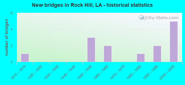
- New bridges - historical statistics
- 11910-1919
- 31950-1959
- 21960-1969
- 11980-1989
- 21990-1999
- 52000-2009

- Bridge Condition - Deck
- 22.2%Very good
- 55.6%Good
- 11.1%Satisfactory
- 11.1%Fair

- Bridge Condition - Superstructure
- 22.2%Very good
- 44.4%Good
- 11.1%Fair
- 22.2%Poor

- Bridge Condition - Substructure
- 44.4%Very good
- 22.2%Good
- 22.2%Fair
- 11.1%Poor

- Bridge Condition - Channel
- 35.7%Good
- 42.9%Satisfactory
- 14.3%Fair
- 7.1%Poor

- Bridge Condition - Culverts
- 60.0%Good
- 40.0%Satisfactory
Find on map >> Show street view
Structure Number: 82200090201871, Location: 1.8 MI SOUTH OF LA 1241 (Lat: 31.425669, Lng: -92.538300), Route carried "on" structure: US 71, Year Built: 1969, Status: Open, Structure Length: 0.67m (2.20ft), Average Daily Traffic: 2,400 (year 2016), Truck Traffic: 15%, Average Future Daily Traffic: 4,032 (year 2036), Design Load: HS 20, Features Intersected: CREEK
Minimum Vertical Clearance: 30+ m (98+ ft), Kilometerpoint: 2.932, Lanes on structure: 2, Base Highway Network: Yes (Inventory Route: 9-02-1, Subroute: 10), Owner: State Highway Agency, Approaching Roadway Width: 13.4m (44.0ft), Skew: 30 degrees, Material/Design: Concrete, Design/Construction: Culvert, Number Of Spans In Main Unit: 4, Length of Maximum Span: 1.5m (4.9ft)
Condition: Channel: Fair, Culverts: Good, Operating Rating: 42.1 metric tons, Method Used To Determine Operating Rating: Load and Resistance Factor Rating (LRFR) rating reported by rating factor(RF) method using HL-93 loadings, Inventory Rating: 32.4 metric tons, Method Used To Determine Inventory Rating: Load and Resistance Factor Rating (LRFR) rating reported by rating factor(RF) method using HL-93 loadings, Structural Evaluation: Better than present minimum criteria, Waterway Adequacy: Somewhat better than minimum adequacy, Approach Roadway Alignment: Somewhat better than minimum adequacy, Designated Inspection Frequency: Every 24 months, Inspection Date: July 2020, Deck Structure Type: Concrete Cast-file-Place
Find on map >> Show street view
Structure Number: 82200090205101, Location: 1.4 MI NORTH OF LA 1241 (Lat: 31.453389, Lng: -92.578700), Route carried "on" structure: US 71, Year Built: 1969, Status: Open, Structure Length: 0.91m (2.99ft), Average Daily Traffic: 2,400 (year 2016), Truck Traffic: 15%, Average Future Daily Traffic: 4,032 (year 2036), Design Load: HS 20, Features Intersected: JAMES BRANCH
Minimum Vertical Clearance: 30+ m (98+ ft), Kilometerpoint: 7.952, Lanes on structure: 2, Base Highway Network: Yes (Inventory Route: 9-02-1, Subroute: 10), Owner: State Highway Agency, Approaching Roadway Width: 13.4m (44.0ft), Skew: 30 degrees, Material/Design: Concrete, Design/Construction: Culvert, Number Of Spans In Main Unit: 4, Length of Maximum Span: 2.1m (6.9ft)
Condition: Channel: Fair, Culverts: Satisfactory, Operating Rating: 42.1 metric tons, Method Used To Determine Operating Rating: Load and Resistance Factor Rating (LRFR) rating reported by rating factor(RF) method using HL-93 loadings, Inventory Rating: 32.4 metric tons, Method Used To Determine Inventory Rating: Load and Resistance Factor Rating (LRFR) rating reported by rating factor(RF) method using HL-93 loadings, Structural Evaluation: Equal to present minimum criteria, Waterway Adequacy: Somewhat better than minimum adequacy, Approach Roadway Alignment: Equal to present minimum criteria, Designated Inspection Frequency: Every 24 months, Inspection Date: July 2020, Deck Structure Type: Concrete Cast-file-Place
Find on map >> Show street view
Structure Number: 82200090207561, Location: 1.1 MI NORTH OF LA 492 (Lat: 31.478039, Lng: -92.608500), Route carried "on" structure: US 71, Year Built: 1950, Status: Open, Structure Length: 7.25m (23.79ft), Average Daily Traffic: 2,500 (year 2016), Truck Traffic: 15%, Average Future Daily Traffic: 4,200 (year 2036), Design Load: HS 20, Features Intersected: BAYOU RIGOLETTE
Minimum Vertical Clearance: 30+ m (98+ ft), Kilometerpoint: 11.888, Lanes on structure: 2, Base Highway Network: Yes (Inventory Route: 9-02-1, Subroute: 10), Owner: State Highway Agency, Approaching Roadway Width: 12.2m (40.0ft), Skew: 30 degrees, Material/Design: Concrete, Design/Construction: Tee Beam, Number Of Spans In Main Unit: 7, Length of Maximum Span: 10.4m (34.1ft), Curb-To-Curb Width: 9.1m (29.9ft), Out-to-Out Width: 10.9m (35.8ft)
Condition: Deck: Good, Superstructure: Poor, Substructure: Fair, Channel: Poor, Operating Rating: 27.5 metric tons, Method Used To Determine Operating Rating: Load and Resistance Factor Rating (LRFR) rating reported by rating factor(RF) method using HL-93 loadings, Inventory Rating: 21.4 metric tons, Method Used To Determine Inventory Rating: Load and Resistance Factor Rating (LRFR) rating reported by rating factor(RF) method using HL-93 loadings, Structural Evaluation: Meets minimum limits, Deck Geometry: Meets minimum limits, Waterway Adequacy: High priority of corrective action, Approach Roadway Alignment: Better than present minimum criteria, Length Of Structure Improvement: 8.17m (26.80ft), Designated Inspection Frequency: Every 24 months, Underwater Inspection Frequency: Every 60 months, Other Special Inspection Frequency: Every 12 months, Inspection Date: August 2020, Underwater Inspection Date: April 2018, Other Special Inspection Date: August 2021, Bridge Improvement Cost: $696,000, Total Project Cost: $1,044,000 ( Estimate for 2016), Deck Structure Type: Concrete Cast-file-Place, Wearing Surface/Protective System: Wearing Surface: Bituminous
Find on map >> Show street view
Structure Number: 82200090207891, Location: 1.4 MI NORTH OF LA 492 (Lat: 31.481369, Lng: -92.612700), Route carried "on" structure: US 71, Year Built: 1950, Status: Open, Structure Length: 1.83m (6.00ft), Average Daily Traffic: 2,500 (year 2016), Truck Traffic: 15%, Average Future Daily Traffic: 4,200 (year 2036), Design Load: HS 20, Features Intersected: CREEK
Minimum Vertical Clearance: 30+ m (98+ ft), Kilometerpoint: 12.435, Lanes on structure: 2, Base Highway Network: Yes (Inventory Route: 9-02-1, Subroute: 10), Owner: State Highway Agency, Approaching Roadway Width: 12.2m (40.0ft), Skew: 34 degrees, Material/Design: Concrete, Design/Construction: Culvert, Number Of Spans In Main Unit: 4, Length of Maximum Span: 4.3m (14.1ft)
Condition: Channel: Satisfactory, Culverts: Satisfactory, Operating Rating: 42.1 metric tons, Method Used To Determine Operating Rating: Load and Resistance Factor Rating (LRFR) rating reported by rating factor(RF) method using HL-93 loadings, Inventory Rating: 32.4 metric tons, Method Used To Determine Inventory Rating: Load and Resistance Factor Rating (LRFR) rating reported by rating factor(RF) method using HL-93 loadings, Structural Evaluation: Equal to present minimum criteria, Waterway Adequacy: Equal to present minimum criteria, Approach Roadway Alignment: Equal to present desirable criteria, Designated Inspection Frequency: Every 24 months, Inspection Date: July 2020, Deck Structure Type: Concrete Cast-file-Place
Find on map >> Show street view
Structure Number: 82200090208461, Location: 2.0 MI NORTH OF LA 492 (Lat: 31.487850, Lng: -92.618500), Route carried "on" structure: US 71, Year Built: 1950, Status: Open, Structure Length: 7.22m (23.69ft), Average Daily Traffic: 2,500 (year 2016), Truck Traffic: 15%, Average Future Daily Traffic: 4,200 (year 2036), Design Load: HS 20, Features Intersected: BAYOU RIGOLETTE
Minimum Vertical Clearance: 30+ m (98+ ft), Kilometerpoint: 13.341, Lanes on structure: 2, Base Highway Network: Yes (Inventory Route: 9-02-1, Subroute: 10), Owner: State Highway Agency, Approaching Roadway Width: 12.2m (40.0ft), Skew: 30 degrees, Material/Design: Concrete, Design/Construction: Tee Beam, Number Of Spans In Main Unit: 7, Length of Maximum Span: 10.4m (34.1ft), Curb-To-Curb Width: 9.1m (29.9ft), Out-to-Out Width: 10.4m (34.1ft)
Condition: Deck: Satisfactory, Superstructure: Poor, Substructure: Poor, Channel: Satisfactory, Operating Rating: 30.1 metric tons, Method Used To Determine Operating Rating: Load and Resistance Factor Rating (LRFR) rating reported by rating factor(RF) method using HL-93 loadings, Inventory Rating: 23.3 metric tons, Method Used To Determine Inventory Rating: Load and Resistance Factor Rating (LRFR) rating reported by rating factor(RF) method using HL-93 loadings, Structural Evaluation: Meets minimum limits, Deck Geometry: Meets minimum limits, Waterway Adequacy: Equal to present minimum criteria, Approach Roadway Alignment: Equal to present desirable criteria, Length Of Structure Improvement: 8.14m (26.71ft), Designated Inspection Frequency: Every 24 months, Underwater Inspection Frequency: Every 60 months, Other Special Inspection Frequency: Every 12 months, Inspection Date: July 2021, Underwater Inspection Date: May 2018, Other Special Inspection Date: August 2019, Bridge Improvement Cost: $694,000, Total Project Cost: $1,041,000 ( Estimate for 2016), Deck Structure Type: Concrete Cast-file-Place, Wearing Surface/Protective System: Wearing Surface: Bituminous
Find on map >> Show street view
Structure Number: 82200093100961, Location: 0.96 MI. WEST OF US 71 (Lat: 31.470311, Lng: -92.608900), Route carried "on" structure: State highway 492, Year Built: 1999, Status: Open, Structure Length: 5.49m (18.01ft), Average Daily Traffic: 870 (year 2016), Truck Traffic: 14%, Average Future Daily Traffic: 1,444 (year 2036), Design Load: HS 20, Features Intersected: BAYOU RIGOLETTE
Minimum Vertical Clearance: 30+ m (98+ ft), Kilometerpoint: 1.543, Lanes on structure: 2, Owner: State Highway Agency, Approaching Roadway Width: 9.1m (29.9ft), Skew: 37 degrees, Material/Design: Concrete, Design/Construction: Slab, Number Of Spans In Main Unit: 9, Length of Maximum Span: 6.1m (20.0ft), Curb-To-Curb Width: 9.0m (29.5ft), Out-to-Out Width: 10.0m (32.8ft)
Condition: Deck: Good, Superstructure: Good, Substructure: Very good, Channel: Satisfactory, Operating Rating: 68.0 metric tons, Method Used To Determine Operating Rating: Load Factor (LF), Inventory Rating: 40.8 metric tons, Method Used To Determine Inventory Rating: Load Factor (LF), Structural Evaluation: Better than present minimum criteria, Deck Geometry: Somewhat better than minimum adequacy, Waterway Adequacy: Equal to present minimum criteria, Approach Roadway Alignment: Equal to present desirable criteria, Designated Inspection Frequency: Every 24 months, Inspection Date: July 2020, Deck Structure Type: Concrete Cast-file-Place, Wearing Surface/Protective System: Wearing Surface: Monolithic Concrete
Find on map >> Show street view
Structure Number: 82200093102121, Location: 2.12 MI. WEST OF US 71 (Lat: 31.475939, Lng: -92.626700), Route carried "on" structure: State highway 492, Year Built: 1999, Status: Open, Structure Length: 6.10m (20.01ft), Average Daily Traffic: 870 (year 2016), Truck Traffic: 14%, Average Future Daily Traffic: 1,444 (year 2036), Design Load: HS 20, Features Intersected: BAYOU DARROW
Minimum Vertical Clearance: 30+ m (98+ ft), Kilometerpoint: 3.381, Lanes on structure: 2, Owner: State Highway Agency, Approaching Roadway Width: 9.1m (29.9ft), Skew: 37 degrees, Material/Design: Concrete, Design/Construction: Slab, Number Of Spans In Main Unit: 10, Length of Maximum Span: 6.1m (20.0ft), Curb-To-Curb Width: 9.0m (29.5ft), Out-to-Out Width: 10.0m (32.8ft)
Condition: Deck: Good, Superstructure: Good, Substructure: Very good, Channel: Good, Operating Rating: 68.0 metric tons, Method Used To Determine Operating Rating: Load Factor (LF), Inventory Rating: 40.8 metric tons, Method Used To Determine Inventory Rating: Load Factor (LF), Structural Evaluation: Better than present minimum criteria, Deck Geometry: Somewhat better than minimum adequacy, Waterway Adequacy: Equal to present minimum criteria, Approach Roadway Alignment: Equal to present desirable criteria, Designated Inspection Frequency: Every 24 months, Inspection Date: July 2020, Deck Structure Type: Concrete Cast-file-Place, Wearing Surface/Protective System: Wearing Surface: Monolithic Concrete
Find on map >> Show street view
Structure Number: 82231259092321, Location: 0.69 M. N. OF JCT US 71 (Lat: 31.432761, Lng: -92.534900), Route carried "on" structure: County highway , Year Built: 2005, Status: Open, Structure Length: 0.82m (2.69ft), Average Daily Traffic: 350 (year 2004), Average Future Daily Traffic: 588 (year 2036), Design Load: HS 20, Features Intersected: HUDSON CREEK, Facility Carried by Structure: Hudson Creek Rd
Minimum Vertical Clearance: 30+ m (98+ ft), Kilometerpoint: 0.900, Lanes on structure: 2, Owner: County Highway Agency, Approaching Roadway Width: 6.1m (20.0ft), Skew: 30 degrees, Material/Design: Concrete, Design/Construction: Culvert, Number Of Spans In Main Unit: 3, Length of Maximum Span: 2.4m (7.9ft)
Condition: Channel: Satisfactory, Culverts: Good, Operating Rating: 52.5 metric tons, Method Used To Determine Operating Rating: Load and Resistance Factor Rating (LRFR) rating reported by rating factor(RF) method using HL-93 loadings, Inventory Rating: 40.5 metric tons, Method Used To Determine Inventory Rating: Load and Resistance Factor Rating (LRFR) rating reported by rating factor(RF) method using HL-93 loadings, Structural Evaluation: Better than present minimum criteria, Waterway Adequacy: Equal to present minimum criteria, Approach Roadway Alignment: Equal to present desirable criteria, Designated Inspection Frequency: Every 24 months, Inspection Date: March 2021, Deck Structure Type: Concrete Precast Panels
Find on map >> Show street view
Structure Number: 82231259923551, Location: 2.53 MI. SOUTH OF US 71 (Lat: 31.430939, Lng: -92.592100), Route carried "on" structure: County highway , Year Built: 2008, Status: Open, Structure Length: 4.88m (16.01ft), Average Daily Traffic: 100 (year 2008), Average Future Daily Traffic: 168 (year 2036), Design Load: HS 20, Features Intersected: WALDEN BAYOU, Facility Carried by Structure: Meade Rd
Minimum Vertical Clearance: 30+ m (98+ ft), Kilometerpoint: 0.735, Lanes on structure: 2, Owner: County Highway Agency, Approaching Roadway Width: 6.7m (22.0ft), Skew: 36 degrees, Material/Design: Concrete, Design/Construction: Slab, Number Of Spans In Main Unit: 8, Length of Maximum Span: 6.1m (20.0ft), Curb-To-Curb Width: 7.1m (23.3ft), Out-to-Out Width: 8.2m (26.9ft)
Condition: Deck: Very good, Superstructure: Very good, Substructure: Good, Channel: Good, Operating Rating: 42.1 metric tons, Method Used To Determine Operating Rating: Load and Resistance Factor Rating (LRFR) rating reported by rating factor(RF) method using HL-93 loadings, Inventory Rating: 32.7 metric tons, Method Used To Determine Inventory Rating: Load and Resistance Factor Rating (LRFR) rating reported by rating factor(RF) method using HL-93 loadings, Structural Evaluation: Better than present minimum criteria, Deck Geometry: Somewhat better than minimum adequacy, Waterway Adequacy: Superior to present desirable criteria, Approach Roadway Alignment: Better than present minimum criteria, Designated Inspection Frequency: Every 24 months, Inspection Date: March 2021, Deck Structure Type: Concrete Cast-file-Place, Wearing Surface/Protective System: Wearing Surface: Monolithic Concrete
Find on map >> Show street view
Structure Number: 82231263923551, Location: 2.04 M. S. OF US 71 (Lat: 31.438311, Lng: -92.592200), Route carried "on" structure: County highway , Year Built: 2005, Status: Open, Structure Length: 3.05m (10.01ft), Average Daily Traffic: 150 (year 2016), Average Future Daily Traffic: 252 (year 2036), Design Load: HS 20, Features Intersected: MEADE CREEK, Facility Carried by Structure: Meade Rd
Minimum Vertical Clearance: 30+ m (98+ ft), Kilometerpoint: 1.556, Lanes on structure: 2, Owner: County Highway Agency, Approaching Roadway Width: 6.1m (20.0ft), Skew: 30 degrees, Material/Design: Concrete, Design/Construction: Slab, Number Of Spans In Main Unit: 5, Length of Maximum Span: 6.1m (20.0ft), Curb-To-Curb Width: 7.3m (24.0ft), Out-to-Out Width: 8.2m (26.9ft)
Condition: Deck: Very good, Superstructure: Very good, Substructure: Good, Channel: Good, Operating Rating: 40.2 metric tons, Method Used To Determine Operating Rating: Load and Resistance Factor Rating (LRFR) rating reported by rating factor(RF) method using HL-93 loadings, Inventory Rating: 30.8 metric tons, Method Used To Determine Inventory Rating: Load and Resistance Factor Rating (LRFR) rating reported by rating factor(RF) method using HL-93 loadings, Structural Evaluation: Better than present minimum criteria, Deck Geometry: Somewhat better than minimum adequacy, Waterway Adequacy: Better than present minimum criteria, Approach Roadway Alignment: Equal to present desirable criteria, Designated Inspection Frequency: Every 24 months, Inspection Date: March 2021, Deck Structure Type: Concrete Precast Panels, Wearing Surface/Protective System: Wearing Surface: Monolithic Concrete
Find on map >> Show street view
Structure Number: 82231280923681, Location: 0.3 M. SE OF LA 492 (Lat: 31.466400, Lng: -92.611500), Route carried "on" structure: County highway , Year Built: 1919, Status: Posted for load, Structure Length: 4.54m (14.90ft), Average Daily Traffic: 40 (year 1974), Average Future Daily Traffic: 67 (year 2036), Design Load: HS 15, Features Intersected: MARTEAU BAYOU, Facility Carried by Structure: Sparrow Lane
Minimum Vertical Clearance: 30+ m (98+ ft), Kilometerpoint: 0.496, Lanes on structure: 1, Owner: County Highway Agency, Approaching Roadway Width: 5.5m (18.0ft), Skew: 30 degrees, Material/Design: Concrete, Design/Construction: Tee Beam, Number Of Spans In Main Unit: 5, Length of Maximum Span: 9.1m (29.9ft), Curb-To-Curb Width: 4.7m (15.4ft), Out-to-Out Width: 5.3m (17.4ft)
Condition: Deck: Fair, Superstructure: Fair, Substructure: Fair, Channel: Satisfactory, Operating Rating: 10.0 metric tons, Method Used To Determine Operating Rating: Load and Resistance Factor Rating (LRFR) rating reported by rating factor(RF) method using HL-93 loadings, Inventory Rating: 7.8 metric tons, Method Used To Determine Inventory Rating: Load and Resistance Factor Rating (LRFR) rating reported by rating factor(RF) method using HL-93 loadings, Structural Evaluation: High priority of corrective action, Deck Geometry: Better than present minimum criteria, Waterway Adequacy: Equal to present minimum criteria, Approach Roadway Alignment: Somewhat better than minimum adequacy, Bridge Posting: Required (Relationship of Operating Rating to Maximum Legal Load: > 39.9% below), Designated Inspection Frequency: Every 24 months, Underwater Inspection Frequency: Every 60 months, Other Special Inspection Frequency: Every 12 months, Inspection Date: Febuary 2021, Underwater Inspection Date: May 2018, Deck Structure Type: Concrete Cast-file-Place, Wearing Surface/Protective System: Wearing Surface: Monolithic Concrete
Find on map >> Show street view
Structure Number: 82231298923231, Location: 5.67 M. N. OF JCT US 167 (Lat: 31.497181, Lng: -92.538100), Route carried "on" structure: County highway , Year Built: 2003, Status: Open, Structure Length: 2.38m (7.81ft), Average Daily Traffic: 250 (year 2002), Average Future Daily Traffic: 420 (year 2036), Design Load: HS 20, Features Intersected: GRAYS CREEK, Facility Carried by Structure: Grays Creek Rd
Minimum Vertical Clearance: 30+ m (98+ ft), Kilometerpoint: 10.826, Lanes on structure: 2, Base Highway Network: Yes, Owner: County Highway Agency, Approaching Roadway Width: 7.3m (24.0ft), Skew: 30 degrees, Material/Design: Concrete, Design/Construction: Slab, Number Of Spans In Main Unit: 4, Length of Maximum Span: 5.8m (19.0ft), Curb-To-Curb Width: 7.1m (23.3ft), Out-to-Out Width: 8.1m (26.6ft)
Condition: Deck: Good, Superstructure: Good, Substructure: Very good, Channel: Good, Operating Rating: 33.4 metric tons, Method Used To Determine Operating Rating: Load and Resistance Factor Rating (LRFR) rating reported by rating factor(RF) method using HL-93 loadings, Inventory Rating: 25.9 metric tons, Method Used To Determine Inventory Rating: Load and Resistance Factor Rating (LRFR) rating reported by rating factor(RF) method using HL-93 loadings, Structural Evaluation: Equal to present minimum criteria, Deck Geometry: Meets minimum limits, Waterway Adequacy: Better than present minimum criteria, Approach Roadway Alignment: Equal to present desirable criteria, Designated Inspection Frequency: Every 24 months, Inspection Date: March 2021, Deck Structure Type: Concrete Cast-file-Place
Find on map >> Show street view
Structure Number: 82231299923231, Location: 5.52 M. N. OF JCT. US 167 (Lat: 31.499231, Lng: -92.538500), Route carried "on" structure: County highway , Year Built: 2003, Status: Open, Structure Length: 4.21m (13.81ft), Average Daily Traffic: 250 (year 2002), Average Future Daily Traffic: 420 (year 2036), Design Load: HS 20, Features Intersected: GRAYS CREEK, Facility Carried by Structure: Grays Creek Rd
Minimum Vertical Clearance: 30+ m (98+ ft), Kilometerpoint: 11.056, Lanes on structure: 2, Base Highway Network: Yes, Owner: County Highway Agency, Approaching Roadway Width: 7.3m (24.0ft), Skew: 30 degrees, Material/Design: Concrete, Design/Construction: Slab, Number Of Spans In Main Unit: 7, Length of Maximum Span: 5.8m (19.0ft), Curb-To-Curb Width: 7.1m (23.3ft), Out-to-Out Width: 8.1m (26.6ft)
Condition: Deck: Good, Superstructure: Good, Substructure: Very good, Channel: Good, Operating Rating: 33.4 metric tons, Method Used To Determine Operating Rating: Load and Resistance Factor Rating (LRFR) rating reported by rating factor(RF) method using HL-93 loadings, Inventory Rating: 25.9 metric tons, Method Used To Determine Inventory Rating: Load and Resistance Factor Rating (LRFR) rating reported by rating factor(RF) method using HL-93 loadings, Structural Evaluation: Equal to present minimum criteria, Deck Geometry: Meets minimum limits, Waterway Adequacy: Better than present minimum criteria, Approach Roadway Alignment: Equal to present desirable criteria, Designated Inspection Frequency: Every 24 months, Inspection Date: March 2021, Deck Structure Type: Concrete Cast-file-Place, Wearing Surface/Protective System: Wearing Surface: Monolithic Concrete
Find on map >> Show street view
Structure Number: 82231301923241, Location: 4.88 M. NE OF JCT US 167 (Lat: 31.501239, Lng: -92.541300), Route carried "on" structure: County highway , Year Built: 1986, Status: Open, Structure Length: 1.55m (5.09ft), Average Daily Traffic: 57 (year 1985), Average Future Daily Traffic: 95 (year 2036), Design Load: HS 20, Features Intersected: CHANDLER CREEK, Facility Carried by Structure: Parsonage Ceme Rd
Minimum Vertical Clearance: 30+ m (98+ ft), Kilometerpoint: 0.283, Lanes on structure: 2, Owner: County Highway Agency, Approaching Roadway Width: 7.3m (24.0ft), Skew: 30 degrees, Material/Design: Concrete, Design/Construction: Culvert, Number Of Spans In Main Unit: 6, Length of Maximum Span: 2.4m (7.9ft)
Condition: Channel: Satisfactory, Culverts: Good, Operating Rating: 42.1 metric tons, Method Used To Determine Operating Rating: Load and Resistance Factor Rating (LRFR) rating reported by rating factor(RF) method using HL-93 loadings, Inventory Rating: 32.4 metric tons, Method Used To Determine Inventory Rating: Load and Resistance Factor Rating (LRFR) rating reported by rating factor(RF) method using HL-93 loadings, Structural Evaluation: Better than present minimum criteria, Waterway Adequacy: Equal to present minimum criteria, Approach Roadway Alignment: Better than present minimum criteria, Designated Inspection Frequency: Every 24 months, Inspection Date: March 2021, Deck Structure Type: Concrete Cast-file-Place