Bridge Statistics for Rockford, Washington (WA)
Condition, Traffic, Stress, Structural Evaluation, Project Costs
- National Bridge Inventory (NBI) Statistics
- 15Number of bridges
- 144ft / 43.9mTotal length
- $21,886,000Total costs
- 26,332Total average daily traffic
- 2,475Total average daily truck traffic
- National Bridge Inventory (NBI) Registered Bridges for Rockford
- No street view available for this location
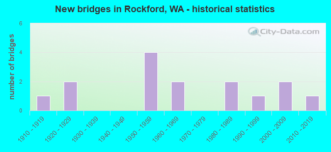
- New bridges - historical statistics
- 11910-1919
- 21920-1929
- 41950-1959
- 21960-1969
- 21980-1989
- 11990-1999
- 22000-2009
- 12010-2019


- Bridge Condition - Deck
- 8.3%Very good
- 50.0%Good
- 33.3%Satisfactory
- 8.3%Serious

- Bridge Condition - Superstructure
- 7.7%Very good
- 61.5%Good
- 23.1%Satisfactory
- 7.7%Fair

- Bridge Condition - Substructure
- 7.7%Very good
- 61.5%Good
- 23.1%Satisfactory
- 7.7%Fair

- Bridge Condition - Channel
- 58.3%Very good
- 33.3%Good
- 8.3%Satisfactory
Find on map >> Show street view
Structure Number: 5397A, Location: 0.2 N JCT SR 278 (Lat: 47.453056, Lng: -117.142083), Route carried "on" structure: State highway 27, Year Built: 1957, Status: Open, Structure Length: 4.33m (14.21ft), Average Daily Traffic: 5,497 (year 2019), Truck Traffic: 8%, Average Future Daily Traffic: 7,080 (year 2039), Design Load: HS 15, Features Intersected: ROCK CREEK
Minimum Vertical Clearance: 30+ m (98+ ft), Kilometerpoint: 111.318, Lanes on structure: 2, Owner: State Highway Agency, Approaching Roadway Width: 10.4m (34.1ft), Material/Design: Concrete continuous, Design/Construction: Tee Beam, Number Of Spans In Main Unit: 3, Length of Maximum Span: 18.3m (60.0ft), Curb or Sidewalk Widths: Left: 0.7m (2.3ft), Right: 0.7m (2.3ft), Curb-To-Curb Width: 7.9m (25.9ft), Out-to-Out Width: 10.2m (33.5ft)
Condition: Deck: Serious, Superstructure: Good, Substructure: Good, Channel: Very good, Operating Rating: 18.1 metric tons, Method Used To Determine Operating Rating: Load and Resistance Factor Rating (LRFR) rating reported by rating factor(RF) method using HL-93 loadings, Inventory Rating: 13.9 metric tons, Method Used To Determine Inventory Rating: Load and Resistance Factor Rating (LRFR) rating reported by rating factor(RF) method using HL-93 loadings, Structural Evaluation: High priority of corrective action, Deck Geometry: High priority of replacement, Waterway Adequacy: Equal to present desirable criteria, Approach Roadway Alignment: Equal to present desirable criteria, Length Of Structure Improvement: 4.33m (14.21ft), Designated Inspection Frequency: Every 24 months, Inspection Date: July 2020, Bridge Improvement Cost: $1,022,000, Roadway Improvement Cost: $204,000, Total Project Cost: $2,045,000 ( Estimate for 2014), Deck Structure Type: Concrete Cast-file-Place, Wearing Surface/Protective System: Wearing Surface: Bituminous, Membrane: Preformed Fabric
Find on map >> Show street view
Structure Number: 80727, Location: 0.2 NE SSH NO 27 (Lat: 47.507000, Lng: -117.152472), Route carried "on" structure: County highway 1122, Year Built: 1961, Status: Open, Structure Length: 4.54m (14.90ft), Average Daily Traffic: 2,089 (year 2020), Truck Traffic: 18%, Average Future Daily Traffic: 3,008 (year 2042), Design Load: HS 15, Features Intersected: UPRR TRACKS, Facility Carried by Structure: ELDER ROAD
Minimum Vertical Clearance: 30+ m (98+ ft), Kilometerpoint: 0.001, Lanes on structure: 2, Owner: County Highway Agency, Approaching Roadway Width: 8.8m (28.9ft), Skew: 4 degrees, Material/Design: Prestressed concrete, Design/Construction: Stringer/Multi-beam, Number Of Spans In Main Unit: 3, Length of Maximum Span: 16.2m (53.1ft), Curb or Sidewalk Widths: Left: 0.6m (2.0ft), Right: 1.2m (3.9ft), Curb-To-Curb Width: 8.0m (26.2ft), Out-to-Out Width: 9.8m (32.2ft)
Condition: Deck: Satisfactory, Superstructure: Fair, Substructure: Satisfactory, Operating Rating: 49.0 metric tons, Method Used To Determine Operating Rating: Load and Resistance Factor (LRFR), Inventory Rating: 29.0 metric tons, Method Used To Determine Inventory Rating: Load and Resistance Factor (LRFR), Structural Evaluation: Somewhat better than minimum adequacy, Deck Geometry: High priority of corrective action, Underclear: Somewhat better than minimum adequacy, Approach Roadway Alignment: Equal to present minimum criteria, Length Of Structure Improvement: 4.54m (14.90ft), Designated Inspection Frequency: Every 24 months, Inspection Date: September 2021, Bridge Improvement Cost: $924,000, Roadway Improvement Cost: $185,000, Total Project Cost: $1,848,000 ( Estimate for 2014), Deck Structure Type: Concrete Cast-file-Place, Wearing Surface/Protective System: Wearing Surface: Monolithic Concrete
Find on map >> Show street view
Structure Number: 80863, Location: 03.0 E FREEMAN (Lat: 47.506678, Lng: -117.132614), Route carried "on" structure: County highway 516, Year Built: 1927, Year Reconstructed: 1993, Status: Open, Structure Length: 3.02m (9.91ft), Average Daily Traffic: 20 (year 2020), Truck Traffic: 35%, Average Future Daily Traffic: 28 (year 2042), Design Load: HS 20, Features Intersected: UNION PACIFIC RAILROAD, Facility Carried by Structure: CAMPBELL ROAD
Minimum Vertical Clearance: 30+ m (98+ ft), Kilometerpoint: 0.001, Lanes on structure: 2, Owner: County Highway Agency, Approaching Roadway Width: 5.2m (17.1ft), Material/Design: Prestressed concrete, Design/Construction: Stringer/Multi-beam, Number Of Spans In Main Unit: 3, Length of Maximum Span: 9.4m (30.8ft), Curb-To-Curb Width: 6.1m (20.0ft), Out-to-Out Width: 6.1m (20.0ft)
Condition: Deck: Good, Superstructure: Good, Substructure: Fair, Operating Rating: 32.7 metric tons, Method Used To Determine Operating Rating: Load Factor (LF), Inventory Rating: 19.0 metric tons, Method Used To Determine Inventory Rating: Load Factor (LF), Structural Evaluation: Somewhat better than minimum adequacy, Deck Geometry: Somewhat better than minimum adequacy, Underclear: Somewhat better than minimum adequacy, Approach Roadway Alignment: Equal to present minimum criteria, Length Of Structure Improvement: 3.02m (9.91ft), Designated Inspection Frequency: Every 24 months, Inspection Date: October 2021, Bridge Improvement Cost: $376,000, Roadway Improvement Cost: $75,000, Total Project Cost: $752,000 ( Estimate for 2014), Deck Structure Type: Other, Wearing Surface/Protective System: Wearing Surface: Monolithic Concrete
Find on map >> Show street view
Structure Number: 83108, Location: 4.0 S FREEMAN (Lat: 47.468819, Lng: -117.195650), Route carried "on" structure: County highway 2103, Year Built: 1960, Status: Open, Structure Length: 2.80m (9.19ft), Average Daily Traffic: 64 (year 2020), Truck Traffic: 34%, Average Future Daily Traffic: 92 (year 2042), Design Load: HS 15, Features Intersected: ROCK CREEK, Facility Carried by Structure: JACKSON ROAD
Minimum Vertical Clearance: 30+ m (98+ ft), Kilometerpoint: 0.001, Lanes on structure: 2, Owner: County Highway Agency, Maintenance Responsibility: City or Municipal Highway Agency, Approaching Roadway Width: 7.9m (25.9ft), Skew: 4 degrees, Material/Design: Prestressed concrete, Design/Construction: Tee Beam, Number Of Spans In Main Unit: 2, Length of Maximum Span: 13.4m (44.0ft), Curb-To-Curb Width: 7.9m (25.9ft), Out-to-Out Width: 8.9m (29.2ft)
Condition: Deck: Satisfactory, Superstructure: Satisfactory, Substructure: Satisfactory, Channel: Good, Operating Rating: 24.9 metric tons, Method Used To Determine Operating Rating: Load and Resistance Factor Rating (LRFR) rating reported by rating factor(RF) method using HL-93 loadings, Inventory Rating: 13.6 metric tons, Method Used To Determine Inventory Rating: Load and Resistance Factor Rating (LRFR) rating reported by rating factor(RF) method using HL-93 loadings, Structural Evaluation: Meets minimum limits, Deck Geometry: Equal to present minimum criteria, Waterway Adequacy: Equal to present desirable criteria, Approach Roadway Alignment: Equal to present minimum criteria, Length Of Structure Improvement: 3.11m (10.20ft), Designated Inspection Frequency: Every 24 months, Inspection Date: September 2020, Bridge Improvement Cost: $1,550,000, Roadway Improvement Cost: $310,000, Total Project Cost: $3,101,000 ( Estimate for 2014), Deck Structure Type: Concrete Cast-file-Place, Wearing Surface/Protective System: Wearing Surface: Monolithic Concrete
Find on map >> Show street view
Structure Number: 84488, Location: 1.2 E JCT SR 27 (Lat: 47.444236, Lng: -117.124758), Route carried "on" structure: State highway 278, Year Built: 1957, Status: Open, Structure Length: 4.66m (15.29ft), Average Daily Traffic: 3,259 (year 2019), Truck Traffic: 9%, Average Future Daily Traffic: 4,197 (year 2039), Design Load: H 15, Features Intersected: ROCK CREEK
Minimum Vertical Clearance: 30+ m (98+ ft), Kilometerpoint: 1.899, Lanes on structure: 2, Owner: State Highway Agency, Approaching Roadway Width: 8.5m (27.9ft), Skew: 4 degrees, Material/Design: Concrete continuous, Design/Construction: Tee Beam, Number Of Spans In Main Unit: 3, Length of Maximum Span: 17.4m (57.1ft), Curb or Sidewalk Widths: Left: 0.3m (1.0ft), Right: 0.3m (1.0ft), Curb-To-Curb Width: 7.9m (25.9ft), Out-to-Out Width: 9.3m (30.5ft)
Condition: Deck: Satisfactory, Superstructure: Good, Substructure: Good, Channel: Satisfactory, Operating Rating: 33.6 metric tons, Method Used To Determine Operating Rating: Load Factor (LF), Inventory Rating: 20.0 metric tons, Method Used To Determine Inventory Rating: Load Factor (LF), Structural Evaluation: Somewhat better than minimum adequacy, Deck Geometry: High priority of corrective action, Waterway Adequacy: Equal to present desirable criteria, Approach Roadway Alignment: Equal to present desirable criteria, Length Of Structure Improvement: 4.66m (15.29ft), Designated Inspection Frequency: Every 24 months, Inspection Date: May 2021, Bridge Improvement Cost: $918,000, Roadway Improvement Cost: $184,000, Total Project Cost: $1,836,000 ( Estimate for 2014), Deck Structure Type: Concrete Cast-file-Place, Wearing Surface/Protective System: Wearing Surface: Bituminous
Find on map >> Show street view
Structure Number: 84632, Location: 2.2 E JCT SR 27 (Lat: 47.440861, Lng: -117.104583), Route carried "on" structure: State highway 278, Year Built: 1950, Status: Posted for load, Structure Length: 4.57m (14.99ft), Average Daily Traffic: 3,206 (year 2019), Truck Traffic: 9%, Average Future Daily Traffic: 4,129 (year 2039), Design Load: HS 15, Features Intersected: ROCK CREEK
Minimum Vertical Clearance: 30+ m (98+ ft), Kilometerpoint: 3.524, Lanes on structure: 2, Owner: State Highway Agency, Approaching Roadway Width: 8.5m (27.9ft), Skew: 4 degrees, Material/Design: Concrete continuous, Design/Construction: Tee Beam, Number Of Spans In Main Unit: 3, Length of Maximum Span: 19.5m (64.0ft), Curb or Sidewalk Widths: Left: 0.3m (1.0ft), Right: 0.3m (1.0ft), Curb-To-Curb Width: 7.9m (25.9ft), Out-to-Out Width: 9.1m (29.9ft)
Condition: Deck: Satisfactory, Superstructure: Good, Substructure: Good, Channel: Very good, Operating Rating: 18.5 metric tons, Method Used To Determine Operating Rating: Load and Resistance Factor Rating (LRFR) rating reported by rating factor(RF) method using HL-93 loadings, Inventory Rating: 14.3 metric tons, Method Used To Determine Inventory Rating: Load and Resistance Factor Rating (LRFR) rating reported by rating factor(RF) method using HL-93 loadings, Structural Evaluation: Meets minimum limits, Deck Geometry: High priority of corrective action, Waterway Adequacy: Equal to present desirable criteria, Approach Roadway Alignment: Equal to present desirable criteria, Bridge Posting: Required (Relationship of Operating Rating to Maximum Legal Load: 0.1 - 9.9% below), Length Of Structure Improvement: 4.57m (14.99ft), Designated Inspection Frequency: Every 24 months, Underwater Inspection Frequency: Every 60 months, Inspection Date: September 2021, Underwater Inspection Date: August 2017, Bridge Improvement Cost: $900,000, Roadway Improvement Cost: $180,000, Total Project Cost: $1,800,000 ( Estimate for 2014), Deck Structure Type: Concrete Cast-file-Place, Wearing Surface/Protective System: Wearing Surface: Bituminous
Find on map >> Show street view
Structure Number: 8464, Location: 2.7 E JCT SR 27 (Lat: 47.438425, Lng: -117.093572), Route carried "on" structure: State highway 278, Year Built: 1956, Status: Open, Structure Length: 2.59m (8.50ft), Average Daily Traffic: 3,206 (year 2019), Truck Traffic: 9%, Average Future Daily Traffic: 4,129 (year 2039), Design Load: H 15, Features Intersected: NORTH FORK ROCK CREEK
Minimum Vertical Clearance: 30+ m (98+ ft), Kilometerpoint: 4.410, Lanes on structure: 2, Owner: State Highway Agency, Approaching Roadway Width: 10.1m (33.1ft), Skew: 1 degrees, Material/Design: Concrete continuous, Design/Construction: Slab, Number Of Spans In Main Unit: 5, Length of Maximum Span: 8.5m (27.9ft), Curb-To-Curb Width: 7.9m (25.9ft), Out-to-Out Width: 9.3m (30.5ft)
Condition: Deck: Good, Superstructure: Satisfactory, Substructure: Good, Channel: Very good, Operating Rating: 31.7 metric tons, Method Used To Determine Operating Rating: Load Factor (LF), Inventory Rating: 19.0 metric tons, Method Used To Determine Inventory Rating: Load Factor (LF), Structural Evaluation: Somewhat better than minimum adequacy, Deck Geometry: High priority of corrective action, Waterway Adequacy: Equal to present desirable criteria, Approach Roadway Alignment: Equal to present desirable criteria, Length Of Structure Improvement: 2.59m (8.50ft), Designated Inspection Frequency: Every 24 months, Inspection Date: June 2021, Bridge Improvement Cost: $595,000, Roadway Improvement Cost: $119,000, Total Project Cost: $1,190,000 ( Estimate for 2014), Deck Structure Type: Concrete Cast-file-Place, Wearing Surface/Protective System: Wearing Surface: Bituminous
Find on map >> Show street view
Structure Number: 84702, Location: 02.0 E ROCKFORD (Lat: 47.444083, Lng: -117.078000), Route carried "on" structure: County highway 913, Year Built: 1986, Status: Open, Structure Length: 2.68m (8.79ft), Average Daily Traffic: 29 (year 2020), Truck Traffic: 52%, Average Future Daily Traffic: 41 (year 2042), Design Load: HS 20, Features Intersected: NORTH FORK ROCK CREEK, Facility Carried by Structure: DUNKLE ROAD
Minimum Vertical Clearance: 30+ m (98+ ft), Kilometerpoint: 0.001, Lanes on structure: 2, Owner: County Highway Agency, Approaching Roadway Width: 9.8m (32.2ft), Material/Design: Prestressed concrete, Design/Construction: Tee Beam, Number Of Spans In Main Unit: 1, Length of Maximum Span: 26.5m (86.9ft), Curb-To-Curb Width: 9.6m (31.5ft), Out-to-Out Width: 9.8m (32.2ft)
Condition: Deck: Good, Superstructure: Good, Substructure: Good, Channel: Good, Operating Rating: 69.8 metric tons, Method Used To Determine Operating Rating: Load Factor (LF), Inventory Rating: 41.7 metric tons, Method Used To Determine Inventory Rating: Load Factor (LF), Structural Evaluation: Better than present minimum criteria, Deck Geometry: Better than present minimum criteria, Waterway Adequacy: Equal to present desirable criteria, Approach Roadway Alignment: Equal to present desirable criteria, Length Of Structure Improvement: 2.68m (8.79ft), Designated Inspection Frequency: Every 24 months, Inspection Date: July 2021, Bridge Improvement Cost: $598,000, Roadway Improvement Cost: $120,000, Total Project Cost: $1,197,000 ( Estimate for 2014), Deck Structure Type: Other, Wearing Surface/Protective System: Wearing Surface: Monolithic Concrete, Deck Protection: Epoxy Coated Reinforcing
Find on map >> Show street view
Structure Number: 85485, Location: 0.4 E JCT SR 27 (Lat: 47.452194, Lng: -117.134861), Route carried "on" structure: State highway 278, Year Built: 1920, Year Reconstructed: 1989, Status: Open, Structure Length: 2.99m (9.81ft), Average Daily Traffic: 4,011 (year 2019), Truck Traffic: 7%, Average Future Daily Traffic: 5,166 (year 2039), Design Load: HS 20, Features Intersected: ROCK CREEK
Minimum Vertical Clearance: 30+ m (98+ ft), Kilometerpoint: 0.579, Lanes on structure: 2, Owner: State Highway Agency, Approaching Roadway Width: 9.8m (32.2ft), Skew: 1 degrees, Material/Design: Concrete continuous, Design/Construction: Arch - Deck, Number Of Spans In Main Unit: 2, Length of Maximum Span: 14.3m (46.9ft), Curb or Sidewalk Widths: Left: 1.2m (3.9ft), Right: 1.5m (4.9ft), Curb-To-Curb Width: 9.8m (32.2ft), Out-to-Out Width: 13.6m (44.6ft)
Condition: Superstructure: Satisfactory, Substructure: Satisfactory, Channel: Very good, Operating Rating: 39.0 metric tons, Method Used To Determine Operating Rating: Load Factor (LF), Inventory Rating: 23.6 metric tons, Method Used To Determine Inventory Rating: Load Factor (LF), Structural Evaluation: Equal to present minimum criteria, Deck Geometry: Meets minimum limits, Waterway Adequacy: Equal to present minimum criteria, Approach Roadway Alignment: Equal to present desirable criteria, Length Of Structure Improvement: 2.99m (9.81ft), Designated Inspection Frequency: Every 24 months, Inspection Date: September 2021, Bridge Improvement Cost: $666,000, Roadway Improvement Cost: $133,000, Total Project Cost: $1,333,000 ( Estimate for 2014)
Find on map >> Show street view
Structure Number: 85761, Location: 0.1 MI N STARR RD (Lat: 47.416856, Lng: -117.066644), Route carried "on" structure: County highway 572, Year Built: 1988, Status: Open, Structure Length: 3.08m (10.10ft), Average Daily Traffic: 48 (year 2020), Truck Traffic: 21%, Average Future Daily Traffic: 69 (year 2042), Design Load: HS 20, Features Intersected: ROSE CREEK, Facility Carried by Structure: CHATCOLET ROAD
Minimum Vertical Clearance: 30+ m (98+ ft), Kilometerpoint: 0.001, Lanes on structure: 2, Owner: County Highway Agency, Approaching Roadway Width: 9.1m (29.9ft), Skew: 3 degrees, Material/Design: Prestressed concrete, Design/Construction: Tee Beam, Number Of Spans In Main Unit: 1, Length of Maximum Span: 30.5m (100.1ft), Curb-To-Curb Width: 9.3m (30.5ft), Out-to-Out Width: 9.4m (30.8ft)
Condition: Deck: Good, Superstructure: Good, Substructure: Good, Channel: Very good, Operating Rating: 59.0 metric tons, Method Used To Determine Operating Rating: Load Factor (LF), Inventory Rating: 35.4 metric tons, Method Used To Determine Inventory Rating: Load Factor (LF), Structural Evaluation: Better than present minimum criteria, Deck Geometry: Better than present minimum criteria, Waterway Adequacy: Equal to present desirable criteria, Approach Roadway Alignment: Equal to present minimum criteria, Length Of Structure Improvement: 3.38m (11.09ft), Designated Inspection Frequency: Every 24 months, Inspection Date: July 2021, Bridge Improvement Cost: $1,687,000, Roadway Improvement Cost: $337,000, Total Project Cost: $3,374,000 ( Estimate for 2014), Deck Structure Type: Other, Wearing Surface/Protective System: Wearing Surface: Monolithic Concrete, Deck Protection: Epoxy Coated Reinforcing
Find on map >> Show street view
Structure Number: 8605, Location: 4.5 MI. E FAIRFIELD (Lat: 47.395017, Lng: -117.079772), Route carried "on" structure: County highway 312, Year Built: 1993, Status: Open, Structure Length: 2.68m (8.79ft), Average Daily Traffic: 140 (year 2020), Truck Traffic: 43%, Average Future Daily Traffic: 201 (year 2042), Design Load: HS 20, Features Intersected: SOUTH FORK ROCK CREEK, Facility Carried by Structure: BRADSHAW ROAD
Minimum Vertical Clearance: 30+ m (98+ ft), Kilometerpoint: 0.001, Lanes on structure: 2, Owner: County Highway Agency, Approaching Roadway Width: 9.1m (29.9ft), Skew: 1 degrees, Material/Design: Prestressed concrete, Design/Construction: Tee Beam, Number Of Spans In Main Unit: 1, Length of Maximum Span: 25.6m (84.0ft), Curb-To-Curb Width: 9.4m (30.8ft), Out-to-Out Width: 9.5m (31.2ft)
Condition: Deck: Good, Superstructure: Good, Substructure: Good, Channel: Good, Operating Rating: 63.5 metric tons, Method Used To Determine Operating Rating: Allowable Stress (AS), Inventory Rating: 38.1 metric tons, Method Used To Determine Inventory Rating: Load Factor (LF), Structural Evaluation: Better than present minimum criteria, Deck Geometry: Equal to present minimum criteria, Waterway Adequacy: Equal to present desirable criteria, Approach Roadway Alignment: Equal to present desirable criteria, Length Of Structure Improvement: 2.68m (8.79ft), Designated Inspection Frequency: Every 24 months, Inspection Date: July 2020, Bridge Improvement Cost: $563,000, Roadway Improvement Cost: $113,000, Total Project Cost: $1,126,000 ( Estimate for 2014), Deck Structure Type: Other, Wearing Surface/Protective System: Wearing Surface: Monolithic Concrete, Deck Protection: Epoxy Coated Reinforcing
Find on map >> Show street view
Structure Number: 87075, Location: 0.1 N RR GRADE XNG (Lat: 47.453986, Lng: -117.132736), Route carried "on" structure: City street 1100, Year Built: 2003, Status: Open, Structure Length: 1.83m (6.00ft), Average Daily Traffic: 71 (year 2016), Truck Traffic: 5%, Average Future Daily Traffic: 102 (year 2038), Design Load: HS 25 or greater, Features Intersected: MICA CREEK, Facility Carried by Structure: FIRST STREET
Minimum Vertical Clearance: 30+ m (98+ ft), Kilometerpoint: 0.001, Lanes on structure: 2, Owner: City or Municipal Highway Agency, Approaching Roadway Width: 7.3m (24.0ft), Skew: 3 degrees, Material/Design: Prestressed concrete, Design/Construction: Stringer/Multi-beam, Number Of Spans In Main Unit: 1, Length of Maximum Span: 18.0m (59.1ft), Curb-To-Curb Width: 7.3m (24.0ft), Out-to-Out Width: 7.4m (24.3ft)
Condition: Deck: Very good, Superstructure: Very good, Substructure: Very good, Channel: Good, Operating Rating: 71.7 metric tons, Method Used To Determine Operating Rating: Load Factor (LF), Inventory Rating: 39.9 metric tons, Method Used To Determine Inventory Rating: Load Factor (LF), Structural Evaluation: Equal to present desirable criteria, Deck Geometry: Equal to present minimum criteria, Waterway Adequacy: Equal to present desirable criteria, Approach Roadway Alignment: Equal to present minimum criteria, Length Of Structure Improvement: 1.83m (6.00ft), Designated Inspection Frequency: Every 24 months, Inspection Date: May 2020, Bridge Improvement Cost: $312,000, Roadway Improvement Cost: $62,000, Total Project Cost: $624,000 ( Estimate for 2014), Deck Structure Type: Concrete Precast Panels, Wearing Surface/Protective System: Wearing Surface: Integral Concrete, Deck Protection: Epoxy Coated Reinforcing
Find on map >> Show street view
Structure Number: 87176, Location: 1.5 S HOXIE ROAD (Lat: 47.420672, Lng: -117.089206), Route carried "on" structure: County highway 572, Year Built: 2004, Status: Open, Structure Length: 3.11m (10.20ft), Average Daily Traffic: 48 (year 2020), Truck Traffic: 29%, Average Future Daily Traffic: 69 (year 2042), Design Load: HL 93, Features Intersected: SOUTH FORK ROCK CREEK, Facility Carried by Structure: CHATCOLET ROAD
Minimum Vertical Clearance: 30+ m (98+ ft), Kilometerpoint: 0.001, Lanes on structure: 2, Owner: County Highway Agency, Approaching Roadway Width: 8.5m (27.9ft), Skew: 2 degrees, Material/Design: Prestressed concrete, Design/Construction: Tee Beam, Number Of Spans In Main Unit: 1, Length of Maximum Span: 30.2m (99.1ft), Curb-To-Curb Width: 9.1m (29.9ft), Out-to-Out Width: 9.8m (32.2ft)
Condition: Deck: Good, Superstructure: Good, Substructure: Good, Channel: Very good, Operating Rating: 82.5 metric tons, Method Used To Determine Operating Rating: Load Factor (LF), Inventory Rating: 48.1 metric tons, Method Used To Determine Inventory Rating: Load Factor (LF), Structural Evaluation: Better than present minimum criteria, Deck Geometry: Better than present minimum criteria, Waterway Adequacy: Equal to present desirable criteria, Approach Roadway Alignment: Equal to present desirable criteria, Length Of Structure Improvement: 3.11m (10.20ft), Designated Inspection Frequency: Every 24 months, Inspection Date: July 2021, Bridge Improvement Cost: $612,000, Roadway Improvement Cost: $122,000, Total Project Cost: $1,224,000 ( Estimate for 2014), Deck Structure Type: Concrete Cast-file-Place, Wearing Surface/Protective System: Wearing Surface: Monolithic Concrete, Deck Protection: Epoxy Coated Reinforcing
Find on map >> Show street view
Structure Number: 88682, Location: 3.0 MI S. FREEMAN (Lat: 47.477947, Lng: -117.201264), Route carried "on" structure: County highway 2103, Year Built: 2014, Status: Open, Structure Length: 1.01m (3.31ft), Average Daily Traffic: 125 (year 2016), Truck Traffic: 17%, Average Future Daily Traffic: 180 (year 2038), Design Load: HL 93, Features Intersected: OCHLARE CREEK, Facility Carried by Structure: JACKSON ROAD
Minimum Vertical Clearance: 30+ m (98+ ft), Kilometerpoint: 0.001, Lanes on structure: 2, Owner: County Highway Agency, Approaching Roadway Width: 9.4m (30.8ft), Skew: 3 degrees, Material/Design: Steel, Design/Construction: Culvert, Number Of Spans In Main Unit: 1, Length of Maximum Span: 6.4m (21.0ft)
Condition: Channel: Very good, Culverts: Very good, Operating Rating: 96.9 metric tons, Method Used To Determine Operating Rating: Load and Resistance Factor Rating (LRFR) rating reported by rating factor(RF) method using HL-93 loadings, Inventory Rating: 96.9 metric tons, Method Used To Determine Inventory Rating: Load and Resistance Factor Rating (LRFR) rating reported by rating factor(RF) method using HL-93 loadings, Structural Evaluation: Equal to present desirable criteria, Waterway Adequacy: Equal to present desirable criteria, Approach Roadway Alignment: Equal to present desirable criteria, Length Of Structure Improvement: 1.01m (3.31ft), Designated Inspection Frequency: Every 24 months, Inspection Date: September 2020, Bridge Improvement Cost: $218,000, Roadway Improvement Cost: $44,000, Total Project Cost: $436,000 ( Estimate for 2014)
Find on map >> Show street view
Structure Number: FQ, Location: 0.1 N JCT SR 278 (Lat: 47.450722, Lng: -117.141528), Route carried "under" structure: State highway 27, Year Built: 1915, Structure Length: 0. m, Average Daily Traffic: 4,519 (year 2019), Truck Traffic: 8%, Features Intersected: STATE ROUTE 27, Facility Carried by Structure: UP RR
Minimum Vertical Clearance: 4.42m (14.50ft), Kilometerpoint: 111.061, Lanes under structure: 2, Material/Design: Steel, Design/Construction: Stringer/Multi-beam, Length of Maximum Span: 8.5m (27.9ft)