Bridge Statistics for Rockville Centre, New York (NY)
Condition, Traffic, Stress, Structural Evaluation, Project Costs
- National Bridge Inventory (NBI) Statistics
- 19Number of bridges
- 56ft / 16.9mTotal length
- $40,201,000Total costs
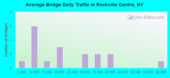
- 358,842Total average daily traffic
- 5,329Total average daily truck traffic
- National Bridge Inventory (NBI) Registered Bridges for Rockville Centre
- No street view available for this location
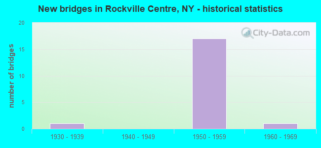
- New bridges - historical statistics
- 11930-1939
- 171950-1959
- 11960-1969
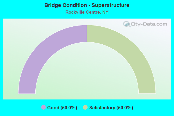
- Bridge Condition - Superstructure
- 50.0%Good
- 50.0%Satisfactory

- Bridge Condition - Substructure
- 25.0%Very good
- 50.0%Satisfactory
- 25.0%Fair
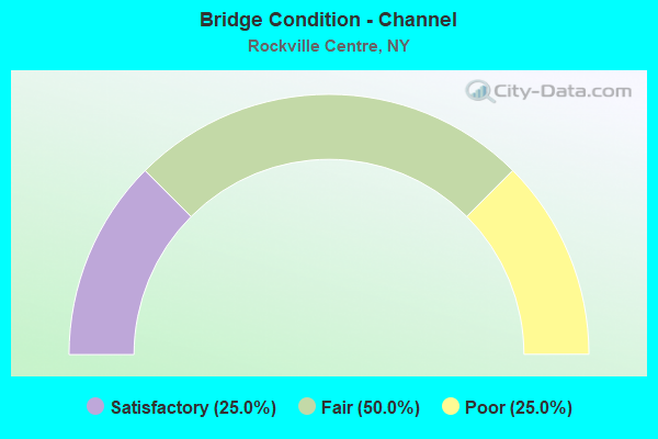
- Bridge Condition - Channel
- 25.0%Satisfactory
- 50.0%Fair
- 25.0%Poor
Find on map >> Show street view
Structure Number: 1018169, Location: 3.9 MI E NYC LINE- SH 27 (Lat: 40.657394, Lng: -73.653858), Route carried "on" structure: State highway 27, Year Built: 1959, Status: Open, Structure Length: 2.16m (7.09ft), Truck Traffic: 6%, Design Load: H 20, Features Intersected: MERRICK ROAD - EB
Minimum Vertical Clearance: 30+ m (98+ ft), Kilometerpoint: 0.097, Lanes on structure: 7, Lanes under structure: 3, Owner: State Highway Agency, Approaching Roadway Width: 35.4m (116.1ft), Skew: 22 degrees, Material/Design: Steel, Design/Construction: Stringer/Multi-beam, Number Of Spans In Main Unit: 1, Length of Maximum Span: 20.1m (65.9ft), Curb or Sidewalk Widths: Left: 0.9m (3.0ft), Right: 0.9m (3.0ft), Curb-To-Curb Width: 33.7m (110.6ft), Out-to-Out Width: 39.4m (129.3ft)
Condition: Deck: Satisfactory, Superstructure: Good, Substructure: Satisfactory, Operating Rating: 79.8 metric tons, Method Used To Determine Operating Rating: Load Factor (LF), Inventory Rating: 47.2 metric tons, Method Used To Determine Inventory Rating: Load Factor (LF), Structural Evaluation: Equal to present minimum criteria, Deck Geometry: Superior to present desirable criteria, Underclear: Meets minimum limits, Approach Roadway Alignment: Equal to present desirable criteria, Length Of Structure Improvement: 2.16m (7.09ft), Designated Inspection Frequency: Every 24 months, Inspection Date: June 2021, Bridge Improvement Cost: $6,157,000, Roadway Improvement Cost: $3,606,000, Total Project Cost: $9,763,000 ( Estimate for 2021), Deck Structure Type: Concrete Cast-file-Place, Wearing Surface/Protective System: Wearing Surface: Integral Concrete
Find on map >> Show street view
Structure Number: 1018179, Location: 3.9 MI E NYC LI ON RTE 27 (Lat: 40.657169, Lng: -73.653378), Route carried "on" structure: State highway 27, Year Built: 1939, Year Reconstructed: 1958, Status: Open, Structure Length: 0.84m (2.76ft), Average Daily Traffic: 33,454 (year 2019), Truck Traffic: 6%, Average Future Daily Traffic: 38,599 (year 2040), Features Intersected: SMITH POND OUTLET
Minimum Vertical Clearance: 30+ m (98+ ft), Kilometerpoint: 6.452, Lanes on structure: 6, Base Highway Network: Yes, Owner: State Highway Agency, Approaching Roadway Width: 25.9m (85.0ft), Skew: 20 degrees, Material/Design: Concrete, Design/Construction: Culvert, Number Of Spans In Main Unit: 2, Length of Maximum Span: 3.7m (12.1ft), Curb or Sidewalk Widths: Left: 0.0m, Right: 1.8m (5.9ft)
Condition: Channel: Fair, Culverts: Satisfactory, Operating Rating: 72.5 metric tons, Method Used To Determine Operating Rating: Field evaluation and documented engineering judgment, Inventory Rating: 32.7 metric tons, Method Used To Determine Inventory Rating: Field evaluation and documented engineering judgment, Structural Evaluation: Equal to present minimum criteria, Waterway Adequacy: Meets minimum limits, Approach Roadway Alignment: Better than present minimum criteria, Length Of Structure Improvement: 0.84m (2.76ft), Designated Inspection Frequency: Every 24 months, Underwater Inspection Frequency: Every 60 months, Inspection Date: October 2021, Underwater Inspection Date: August 2016, Bridge Improvement Cost: $3,962,000, Roadway Improvement Cost: $2,320,000, Total Project Cost: $6,282,000 ( Estimate for 2021)
Find on map >> Show street view
Structure Number: 10561, Location: 4 MI E NYC L-RTE 27 (Lat: 40.657181, Lng: -73.651914), Route carried "on" structure: County highway , Year Built: 1959, Status: Open, Structure Length: 8.53m (27.99ft), Average Daily Traffic: 38,280 (year 2020), Truck Traffic: 3%, Average Future Daily Traffic: 46,502 (year 2040), Design Load: H 20, Features Intersected: 27 27 0304 1042, EB, RTE, Facility Carried by Structure: MERRICK ROAD WB
Minimum Vertical Clearance: 30+ m (98+ ft), Kilometerpoint: 6.887, Lanes on structure: 3, Lanes under structure: 8, Owner: State Highway Agency, Approaching Roadway Width: 11.0m (36.1ft), Skew: 3 degrees, Material/Design: Steel continuous, Design/Construction: Stringer/Multi-beam, Number Of Spans In Main Unit: 3, Length of Maximum Span: 30.1m (98.8ft), Curb or Sidewalk Widths: Left: 0.9m (3.0ft), Right: 0.9m (3.0ft), Curb-To-Curb Width: 11.0m (36.1ft), Out-to-Out Width: 13.4m (44.0ft)
Condition: Deck: Satisfactory, Superstructure: Good, Substructure: Satisfactory, Operating Rating: 68.9 metric tons, Method Used To Determine Operating Rating: Load Factor (LF), Inventory Rating: 41.7 metric tons, Method Used To Determine Inventory Rating: Load Factor (LF), Structural Evaluation: Equal to present minimum criteria, Deck Geometry: High priority of replacement, Underclear: High priority of corrective action, Approach Roadway Alignment: Equal to present desirable criteria, Length Of Structure Improvement: 8.53m (27.99ft), Designated Inspection Frequency: Every 24 months, Inspection Date: September 2021, Bridge Improvement Cost: $5,422,000, Roadway Improvement Cost: $3,175,000, Total Project Cost: $8,598,000 ( Estimate for 2021), Deck Structure Type: Concrete Cast-file-Place, Wearing Surface/Protective System: Wearing Surface: Integral Concrete
Find on map >> Show street view
Structure Number: 15202, Location: 3.3 MI E NYC LINE ON SSP (Lat: 40.682525, Lng: -73.663331), Route carried "on" structure: County highway , Year Built: 1956, Status: Open, Structure Length: 2.32m (7.61ft), Average Daily Traffic: 33,078 (year 2020), Truck Traffic: 2%, Average Future Daily Traffic: 40,183 (year 2040), Design Load: HS 20, Features Intersected: RTE 908M, Facility Carried by Structure: HEMPSTEAD AVENUE
Minimum Vertical Clearance: 30+ m (98+ ft), Kilometerpoint: 3.041, Lanes on structure: 4, Lanes under structure: 4, Owner: State Highway Agency, Approaching Roadway Width: 13.7m (44.9ft), Skew: 1 degrees, Material/Design: Concrete, Design/Construction: Arch - Deck, Number Of Spans In Main Unit: 1, Length of Maximum Span: 21.6m (70.9ft), Curb or Sidewalk Widths: Left: 0.0m, Right: 1.2m (3.9ft), Curb-To-Curb Width: 13.7m (44.9ft), Out-to-Out Width: 18.9m (62.0ft)
Condition: Superstructure: Satisfactory, Substructure: Very good, Operating Rating: 88.0 metric tons, Method Used To Determine Operating Rating: Field evaluation and documented engineering judgment, Inventory Rating: 32.7 metric tons, Method Used To Determine Inventory Rating: Field evaluation and documented engineering judgment, Structural Evaluation: Equal to present minimum criteria, Deck Geometry: High priority of replacement, Underclear: High priority of corrective action, Approach Roadway Alignment: Equal to present desirable criteria, Length Of Structure Improvement: 2.31m (7.58ft), Designated Inspection Frequency: Every 24 months, Inspection Date: March 2021, Bridge Improvement Cost: $3,510,000, Roadway Improvement Cost: $2,055,000, Total Project Cost: $5,565,000 ( Estimate for 2021), Wearing Surface/Protective System: Wearing Surface: Bituminous
Find on map >> Show street view
Structure Number: 330005, Location: IN MALVERNE (Lat: 40.667247, Lng: -73.651900), Route carried "on" structure: County highway , Year Built: 1963, Status: Open, Structure Length: 0.98m (3.22ft), Average Daily Traffic: 5,589 (year 2020), Truck Traffic: 6%, Average Future Daily Traffic: 6,789 (year 2040), Design Load: H 20, Features Intersected: PINES BROOK, Facility Carried by Structure: LAKEVIEW AVENUE
Minimum Vertical Clearance: 30+ m (98+ ft), Kilometerpoint: 1.738, Lanes on structure: 2, Owner: County Highway Agency, Approaching Roadway Width: 11.6m (38.1ft), Material/Design: Concrete continuous, Design/Construction: Culvert, Number Of Spans In Main Unit: 3, Length of Maximum Span: 3.3m (10.8ft), Curb or Sidewalk Widths: Left: 1.2m (3.9ft), Right: 1.2m (3.9ft), Curb-To-Curb Width: 11.6m (38.1ft), Out-to-Out Width: 21.3m (69.9ft)
Condition: Channel: Satisfactory, Culverts: Satisfactory, Operating Rating: 50.8 metric tons, Method Used To Determine Operating Rating: Load Factor (LF), Inventory Rating: 29.9 metric tons, Method Used To Determine Inventory Rating: Load Factor (LF), Structural Evaluation: Equal to present minimum criteria, Deck Geometry: Somewhat better than minimum adequacy, Waterway Adequacy: Meets minimum limits, Approach Roadway Alignment: Equal to present desirable criteria, Length Of Structure Improvement: 0.97m (3.18ft), Designated Inspection Frequency: Every 24 months, Inspection Date: Febuary 2020, Bridge Improvement Cost: $1,089,000, Roadway Improvement Cost: $638,000, Total Project Cost: $1,727,000 ( Estimate for 2021), Wearing Surface/Protective System: Wearing Surface: Bituminous
Find on map >> Show street view
Structure Number: 330008, Location: 3.9 MI E NYC LI ON RTE 27 (Lat: 40.658194, Lng: -73.653931), Route carried "on" structure: Ramp County highway , Year Built: 1958, Status: Open, Structure Length: 1.01m (3.31ft), Average Daily Traffic: 38,280 (year 2020), Truck Traffic: 3%, Average Future Daily Traffic: 46,502 (year 2040), Features Intersected: SMITH POND OUTLET, Facility Carried by Structure: MERRICK ROAD
Minimum Vertical Clearance: 30+ m (98+ ft), Kilometerpoint: 6.629, Lanes on structure: 3, Owner: County Highway Agency, Approaching Roadway Width: 6.7m (22.0ft), Material/Design: Concrete continuous, Design/Construction: Culvert, Number Of Spans In Main Unit: 4, Length of Maximum Span: 2.1m (6.9ft), Curb or Sidewalk Widths: Left: 0.0m, Right: 2.4m (7.9ft), Out-to-Out Width: 137.2m (450.1ft)
Condition: Channel: Fair, Culverts: Satisfactory, Operating Rating: 63.5 metric tons, Method Used To Determine Operating Rating: Load Factor (LF), Inventory Rating: 38.1 metric tons, Method Used To Determine Inventory Rating: Load Factor (LF), Structural Evaluation: Equal to present minimum criteria, Waterway Adequacy: Meets minimum limits, Approach Roadway Alignment: Equal to present minimum criteria, Length Of Structure Improvement: 1.00m (3.28ft), Designated Inspection Frequency: Every 24 months, Inspection Date: Febuary 2020, Bridge Improvement Cost: $4,619,000, Roadway Improvement Cost: $2,705,000, Total Project Cost: $7,324,000 ( Estimate for 2021), Wearing Surface/Protective System: Wearing Surface: Monolithic Concrete, Membrane: Other
Find on map >> Show street view
Structure Number: 330021, Location: .6 MI SW OF ROCKVILLE CTR (Lat: 40.652636, Lng: -73.654494), Route carried "on" structure: County highway , Year Built: 1952, Status: Open, Structure Length: 1.04m (3.41ft), Average Daily Traffic: 1,542 (year 2020), Truck Traffic: 2%, Average Future Daily Traffic: 1,907 (year 2040), Features Intersected: MILL RIVER, Facility Carried by Structure: PARK AVENUE
Minimum Vertical Clearance: 30+ m (98+ ft), Kilometerpoint: 0.338, Lanes on structure: 2, Owner: County Highway Agency, Approaching Roadway Width: 10.4m (34.1ft), Material/Design: Concrete continuous, Design/Construction: Slab, Number Of Spans In Main Unit: 2, Length of Maximum Span: 4.9m (16.1ft), Curb or Sidewalk Widths: Left: 2.1m (6.9ft), Right: 2.1m (6.9ft), Curb-To-Curb Width: 10.4m (34.1ft), Out-to-Out Width: 15.3m (50.2ft)
Condition: Deck: Satisfactory, Superstructure: Satisfactory, Substructure: Fair, Channel: Poor, Operating Rating: 82.6 metric tons, Method Used To Determine Operating Rating: Load Factor (LF), Inventory Rating: 49.0 metric tons, Method Used To Determine Inventory Rating: Load Factor (LF), Structural Evaluation: Somewhat better than minimum adequacy, Deck Geometry: Equal to present minimum criteria, Waterway Adequacy: Equal to present desirable criteria, Approach Roadway Alignment: Equal to present desirable criteria, Length Of Structure Improvement: 1.03m (3.38ft), Designated Inspection Frequency: Every 24 months, Inspection Date: Febuary 2020, Bridge Improvement Cost: $594,000, Roadway Improvement Cost: $348,000, Total Project Cost: $942,000 ( Estimate for 2021), Wearing Surface/Protective System: Wearing Surface: Bituminous
Find on map >> Show street view
Structure Number: 1018169, Location: 3.9 MI E NYC LINE- SH 27 (Lat: 40.657394, Lng: -73.653858), Route carried "under" structure: ServiceCounty highway , Year Built: 1959, Structure Length: 0. m, Average Daily Traffic: 15,851 (year 2003), Features Intersected: MERRICK ROAD - EB, Facility Carried by Structure: RTE 27
Minimum Vertical Clearance: 4.45m (14.60ft), Kilometerpoint: 0.000, Lanes on structure: 7, Lanes under structure: 3, Material/Design: Steel, Design/Construction: Stringer/Multi-beam, Length of Maximum Span: 20.1m (65.9ft)
Find on map >> Show street view
Structure Number: 10561, Location: 4 MI E NYC L-RTE 27 (Lat: 40.657181, Lng: -73.651914), Route carried "under" structure: State highway , Year Built: 1959, Structure Length: 0. m, Average Daily Traffic: 5,000 (year 2021), Features Intersected: 27 27 0304 1042, EB, RTE, Facility Carried by Structure: MERRICK ROAD WB
Minimum Vertical Clearance: 6.53m (21.42ft), Kilometerpoint: 6.677, Lanes on structure: 3, Lanes under structure: 2, Material/Design: Steel continuous, Design/Construction: Stringer/Multi-beam, Length of Maximum Span: 30.1m (98.8ft)
Find on map >> Show street view
Structure Number: 10561, Location: 4 MI E NYC L-RTE 27 (Lat: 40.657181, Lng: -73.651914), Route carried "under" structure: State highway 27, Year Built: 1959, Structure Length: 0. m, Average Daily Traffic: 55,268 (year 2000), Features Intersected: 27 27 0304 1042, EB, RTE, Facility Carried by Structure: MERRICK ROAD WB
Minimum Vertical Clearance: 6.38m (20.93ft), Kilometerpoint: 6.677, Lanes on structure: 3, Lanes under structure: 3, Material/Design: Steel continuous, Design/Construction: Stringer/Multi-beam, Length of Maximum Span: 30.1m (98.8ft)
Find on map >> Show street view
Structure Number: 336056, Location: 1.4 MI N ROCKVILLE CENTRE (Lat: 40.671111, Lng: -73.646422), Route carried "under" structure: County highway , Year Built: 1953, Structure Length: 0. m, Average Daily Traffic: 29,000 (year 1978), Features Intersected: PENINSULA BLVD, Facility Carried by Structure: PED WALK(NR BWAY)
Minimum Vertical Clearance: 4.34m (14.24ft), Kilometerpoint: 0.000, Lanes under structure: 4, Material/Design: Steel, Design/Construction: Girder and Floorbeam System, Length of Maximum Span: 21.3m (69.9ft)
Find on map >> Show street view
Structure Number: 336059, Location: AT ROCKVILLE CENTRE (Lat: 40.656558, Lng: -73.652644), Route carried "under" structure: County highway , Year Built: 1956, Structure Length: 0. m, Average Daily Traffic: 29,500 (year 1978), Features Intersected: MERRICK ROAD, Facility Carried by Structure: PED (NR MILL RVR)
Minimum Vertical Clearance: 4.34m (14.24ft), Kilometerpoint: 0.000, Lanes under structure: 4, Material/Design: Steel, Design/Construction: Girder and Floorbeam System, Length of Maximum Span: 28.6m (93.8ft)
Find on map >> Show street view
Structure Number: 7709781, Location: 0.4 MI W OF ROCKVILLE CTR (Lat: 40.658153, Lng: -73.654231), Route carried "under" structure: County highway , Year Built: 1950, Structure Length: 0. m, Average Daily Traffic: 17,000 (year 1977), Features Intersected: MERRICK RD, Facility Carried by Structure: LIRR MONTAUK BR
Minimum Vertical Clearance: 4.47m (14.67ft), Kilometerpoint: 0.000, Lanes under structure: 5, Material/Design: Steel, Design/Construction: Girder and Floorbeam System, Length of Maximum Span: 29.2m (95.8ft)
Find on map >> Show street view
Structure Number: 7709782, Location: 0.4 MI W OF ROCKVILLE CTR (Lat: 40.658208, Lng: -73.653797), Route carried "under" structure: County highway , Year Built: 1950, Structure Length: 0. m, Average Daily Traffic: 17,000 (year 1977), Features Intersected: MERRICK ROAD, Facility Carried by Structure: LIRR-MTK BR,NO TR
Minimum Vertical Clearance: 4.47m (14.67ft), Kilometerpoint: 0.000, Lanes under structure: 5, Material/Design: Steel, Design/Construction: Girder and Floorbeam System, Length of Maximum Span: 30.4m (99.7ft)
Find on map >> Show street view
Structure Number: 77098, Location: 0.2 MI W OF ROCKVILLE CTR (Lat: 40.658394, Lng: -73.650819), Route carried "under" structure: Other road , Year Built: 1950, Structure Length: 0. m, Average Daily Traffic: 7,000 (year 2021), Features Intersected: BANKS AVE, Facility Carried by Structure: LIRR MONTAUK BR
Minimum Vertical Clearance: 4.29m (14.07ft), Kilometerpoint: 0.000, Lanes under structure: 2, Material/Design: Steel, Design/Construction: Girder and Floorbeam System, Length of Maximum Span: 20.1m (65.9ft)
Find on map >> Show street view
Structure Number: 770981, Location: AT ROCKVILLE CENTER (Lat: 40.658389, Lng: -73.647872), Route carried "under" structure: County highway , Year Built: 1950, Structure Length: 0. m, Average Daily Traffic: 7,000 (year 1977), Features Intersected: N VILLAGE AVE, Facility Carried by Structure: LIRR MONTAUK BR
Minimum Vertical Clearance: 4.21m (13.81ft), Kilometerpoint: 0.000, Lanes under structure: 13, Material/Design: Concrete continuous, Design/Construction: Slab, Length of Maximum Span: 14.9m (48.9ft)
Find on map >> Show street view
Structure Number: 770982, Location: 0.5 MI E OF ROCKVILLE CTR (Lat: 40.657911, Lng: -73.637539), Route carried "under" structure: Other road , Year Built: 1950, Structure Length: 0. m, Average Daily Traffic: 7,000 (year 2021), Features Intersected: FOREST AVE, Facility Carried by Structure: LIRR MONTAUK BR
Minimum Vertical Clearance: 4.31m (14.14ft), Kilometerpoint: 0.000, Lanes under structure: 2, Material/Design: Steel, Design/Construction: Girder and Floorbeam System, Length of Maximum Span: 17.0m (55.8ft)
Find on map >> Show street view
Structure Number: 770983, Location: 0.8 MI E OF ROCKVILLE CTR (Lat: 40.657650, Lng: -73.631636), Route carried "under" structure: County highway , Year Built: 1950, Structure Length: 0. m, Average Daily Traffic: 12,000 (year 1977), Features Intersected: LONG BEACH RD, Facility Carried by Structure: LIRR MONTAUK BR
Minimum Vertical Clearance: 4.31m (14.14ft), Kilometerpoint: 0.000, Lanes under structure: 2, Material/Design: Steel, Design/Construction: Girder and Floorbeam System, Length of Maximum Span: 23.4m (76.8ft)
Find on map >> Show street view
Structure Number: 770984, Location: 0.9 MI E OF ROCKVILLE CTR (Lat: 40.657608, Lng: -73.630628), Route carried "under" structure: County highway , Year Built: 1950, Structure Length: 0. m, Average Daily Traffic: 7,000 (year 1977), Features Intersected: OCEANSIDE RD, Facility Carried by Structure: LIRR MONTAUK BR
Minimum Vertical Clearance: 4.21m (13.81ft), Kilometerpoint: 0.000, Lanes under structure: 4, Material/Design: Steel, Design/Construction: Girder and Floorbeam System, Length of Maximum Span: 18.2m (59.7ft)