Bridge Statistics for Rockwood, Virginia (VA)
Condition, Traffic, Stress, Structural Evaluation, Project Costs
- National Bridge Inventory (NBI) Statistics
- 31Number of bridges
- 354ft / 108mTotal length
- $783,000Total costs
- 599,675Total average daily traffic
- 16,952Total average daily truck traffic
- National Bridge Inventory (NBI) Registered Bridges for Rockwood
- No street view available for this location
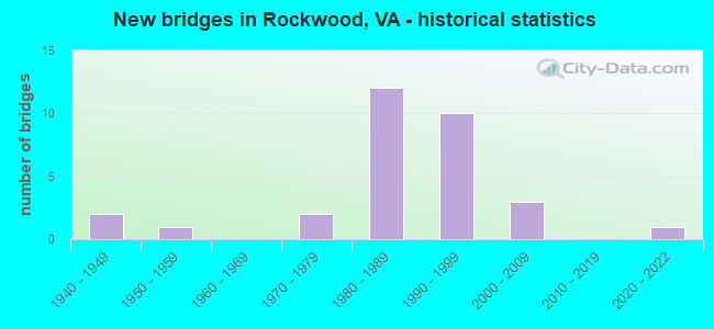
- New bridges - historical statistics
- 21940-1949
- 11950-1959
- 21970-1979
- 121980-1989
- 101990-1999
- 32000-2009
- 12020-2022
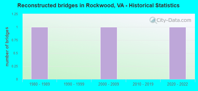
- Reconstructed bridges - Historical Statistics
- 11980-1989
- 01990-1999
- 12000-2009
- 02010-2019
- 12020-2022
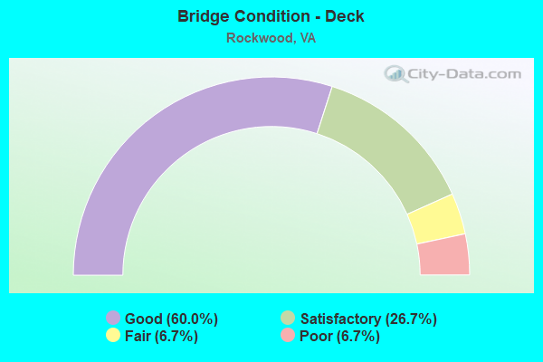
- Bridge Condition - Deck
- 60.0%Good
- 26.7%Satisfactory
- 6.7%Fair
- 6.7%Poor
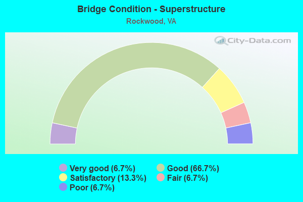
- Bridge Condition - Superstructure
- 6.7%Very good
- 66.7%Good
- 13.3%Satisfactory
- 6.7%Fair
- 6.7%Poor
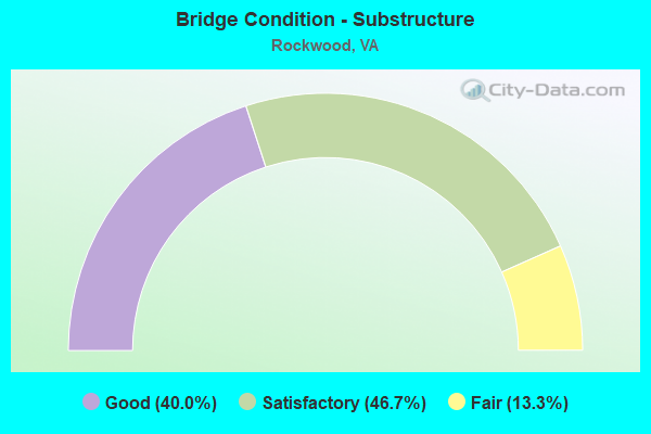
- Bridge Condition - Substructure
- 40.0%Good
- 46.7%Satisfactory
- 13.3%Fair
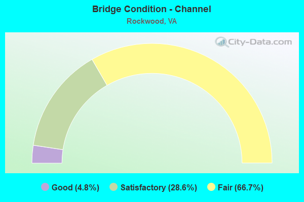
- Bridge Condition - Channel
- 4.8%Good
- 28.6%Satisfactory
- 66.7%Fair
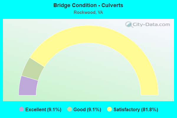
- Bridge Condition - Culverts
- 9.1%Excellent
- 9.1%Good
- 81.8%Satisfactory
Find on map >> Show street view
Structure Number: 5034, Location: 2.10 Fr 653 & 0.75 To 60 (Lat: 37.486344, Lng: -77.568544), Route carried "on" structure: State highway 76, Year Built: 1988, Status: Open, Structure Length: 9.20m (30.18ft), Average Daily Traffic: 41,820 (year 2020), Truck Traffic: 2%, Average Future Daily Traffic: 49,425 (year 2040), Design Load: HS 20+Mod, Features Intersected: POCOSHOCK CREEK
Minimum Vertical Clearance: 30+ m (98+ ft), Kilometerpoint: 9.445, Lanes on structure: 4, Base Highway Network: Yes, Toll: On toll road, Owner: State Highway Agency, Approaching Roadway Width: 22.6m (74.1ft), Skew: 30 degrees, Material/Design: Prestressed concrete, Design/Construction: Stringer/Multi-beam, Number Of Spans In Main Unit: 5, Length of Maximum Span: 18.6m (61.0ft), Curb-To-Curb Width: 22.7m (74.5ft), Out-to-Out Width: 24.3m (79.7ft)
Condition: Deck: Good, Superstructure: Satisfactory, Substructure: Satisfactory, Channel: Fair, Inventory Rating: 75.1 metric tons, Method Used To Determine Inventory Rating: Load and Resistance Factor (LRFR), Structural Evaluation: Equal to present minimum criteria, Deck Geometry: Superior to present desirable criteria, Waterway Adequacy: Equal to present desirable criteria, Approach Roadway Alignment: Equal to present desirable criteria, Designated Inspection Frequency: Every 24 months, Inspection Date: July 2020, Deck Structure Type: Concrete Precast Panels, Wearing Surface/Protective System: Deck Protection: Epoxy Coated Reinforcing
Find on map >> Show street view
Structure Number: 5035, Location: 0.91 Fr 288 & 1.32 TO 653 (Lat: 37.462461, Lng: -77.623231), Route carried "on" structure: State highway 76, Year Built: 1988, Status: Open, Structure Length: 7.13m (23.39ft), Average Daily Traffic: 18,571 (year 2020), Truck Traffic: 2%, Average Future Daily Traffic: 26,001 (year 2040), Design Load: HS 20+Mod, Features Intersected: FALLING CREEK, Facility Carried by Structure: POWHITE PKWY EBL
Minimum Vertical Clearance: 30+ m (98+ ft), Kilometerpoint: 3.434, Lanes on structure: 2, Base Highway Network: Yes, Toll: On toll road, Owner: State Highway Agency, Approaching Roadway Width: 11.9m (39.0ft), Material/Design: Prestressed concrete continuous, Design/Construction: Stringer/Multi-beam, Number Of Spans In Main Unit: 3, Length of Maximum Span: 23.8m (78.1ft), Curb-To-Curb Width: 11.7m (38.4ft), Out-to-Out Width: 12.7m (41.7ft)
Condition: Deck: Good, Superstructure: Good, Substructure: Satisfactory, Channel: Satisfactory, Operating Rating: 71.7 metric tons, Method Used To Determine Operating Rating: Load and Resistance Factor (LRFR), Inventory Rating: 55.3 metric tons, Method Used To Determine Inventory Rating: Load and Resistance Factor (LRFR), Structural Evaluation: Equal to present minimum criteria, Deck Geometry: Equal to present minimum criteria, Waterway Adequacy: Equal to present desirable criteria, Approach Roadway Alignment: Equal to present desirable criteria, Designated Inspection Frequency: Every 24 months, Inspection Date: October 2020, Deck Structure Type: Concrete Precast Panels, Wearing Surface/Protective System: Deck Protection: Epoxy Coated Reinforcing
Find on map >> Show street view
Structure Number: 5036, Location: 0.91 Fr 288 & 1.32 To 653 (Lat: 37.462619, Lng: -77.623225), Route carried "on" structure: State highway 76, Year Built: 1988, Status: Open, Structure Length: 7.13m (23.39ft), Average Daily Traffic: 18,571 (year 2020), Truck Traffic: 2%, Average Future Daily Traffic: 26,001 (year 2040), Design Load: HS 20+Mod, Features Intersected: FALLING CREEK, Facility Carried by Structure: POWHITE PKWY WBL
Minimum Vertical Clearance: 30+ m (98+ ft), Kilometerpoint: 3.434, Lanes on structure: 2, Base Highway Network: Yes, Toll: On toll road, Owner: State Highway Agency, Approaching Roadway Width: 11.9m (39.0ft), Material/Design: Prestressed concrete continuous, Design/Construction: Stringer/Multi-beam, Number Of Spans In Main Unit: 3, Length of Maximum Span: 23.8m (78.1ft), Curb-To-Curb Width: 11.7m (38.4ft), Out-to-Out Width: 12.7m (41.7ft)
Condition: Deck: Good, Superstructure: Good, Substructure: Satisfactory, Channel: Satisfactory, Operating Rating: 71.7 metric tons, Method Used To Determine Operating Rating: Load and Resistance Factor (LRFR), Inventory Rating: 55.3 metric tons, Method Used To Determine Inventory Rating: Load and Resistance Factor (LRFR), Structural Evaluation: Equal to present minimum criteria, Deck Geometry: Equal to present minimum criteria, Waterway Adequacy: Equal to present desirable criteria, Approach Roadway Alignment: Equal to present desirable criteria, Designated Inspection Frequency: Every 24 months, Inspection Date: October 2020, Deck Structure Type: Concrete Precast Panels, Wearing Surface/Protective System: Deck Protection: Epoxy Coated Reinforcing
Find on map >> Show street view
Structure Number: 5041, Location: 1.00 Fr 288 & 1.17 To 653 (Lat: 37.462864, Lng: -77.619192), Route carried "on" structure: State highway 76, Year Built: 1988, Status: Open, Structure Length: 0.81m (2.66ft), Average Daily Traffic: 37,143 (year 2020), Truck Traffic: 2%, Average Future Daily Traffic: 44,272 (year 2040), Design Load: H 20, Features Intersected: BR. OF FALLING CREEK, Facility Carried by Structure: POWHITE PARKWAY
Minimum Vertical Clearance: 30+ m (98+ ft), Kilometerpoint: 4.114, Lanes on structure: 4, Base Highway Network: Yes, Toll: On toll road, Owner: State Highway Agency, Approaching Roadway Width: 26.2m (86.0ft), Skew: 24 degrees, Material/Design: Concrete, Design/Construction: Culvert, Number Of Spans In Main Unit: 3, Length of Maximum Span: 2.7m (8.9ft)
Condition: Channel: Fair, Culverts: Satisfactory, Operating Rating: 89.8 metric tons, Method Used To Determine Operating Rating: Field evaluation and documented engineering judgment, Inventory Rating: 89.8 metric tons, Method Used To Determine Inventory Rating: Field evaluation and documented engineering judgment, Structural Evaluation: Equal to present minimum criteria, Waterway Adequacy: Equal to present desirable criteria, Approach Roadway Alignment: Equal to present desirable criteria, Designated Inspection Frequency: Every 24 months, Inspection Date: October 2020
Find on map >> Show street view
Structure Number: 5042, Location: 2.32 Fr 288 & 0.22 To 653 (Lat: 37.411250, Lng: -77.581889), Route carried "on" structure: State highway 76, Year Built: 1988, Status: Open, Structure Length: 1.34m (4.40ft), Average Daily Traffic: 41,820 (year 2020), Truck Traffic: 2%, Average Future Daily Traffic: 49,425 (year 2040), Design Load: HS 20+Mod, Features Intersected: UNNAMED TRIBUTARY, Facility Carried by Structure: POWHITE PARKWAY
Minimum Vertical Clearance: 30+ m (98+ ft), Kilometerpoint: 5.905, Lanes on structure: 14, Base Highway Network: Yes, Toll: On toll road, Owner: State Highway Agency, Approaching Roadway Width: 64.0m (210.0ft), Skew: 1 degrees, Material/Design: Concrete, Design/Construction: Culvert, Number Of Spans In Main Unit: 4, Length of Maximum Span: 3.4m (11.2ft)
Condition: Channel: Fair, Culverts: Satisfactory, Operating Rating: 89.8 metric tons, Method Used To Determine Operating Rating: Field evaluation and documented engineering judgment, Inventory Rating: 89.8 metric tons, Method Used To Determine Inventory Rating: Field evaluation and documented engineering judgment, Structural Evaluation: Equal to present minimum criteria, Waterway Adequacy: Equal to present desirable criteria, Approach Roadway Alignment: Equal to present desirable criteria, Designated Inspection Frequency: Every 24 months, Inspection Date: October 2020
Find on map >> Show street view
Structure Number: 515, Location: 0.90 Fr 604 & 2.97 To 360 (Lat: 37.411258, Lng: -77.582342), Route carried "on" structure: State highway 288, Year Built: 1990, Status: Open, Structure Length: 4.02m (13.19ft), Average Daily Traffic: 19,974 (year 2020), Truck Traffic: 5%, Average Future Daily Traffic: 27,964 (year 2040), Design Load: H 20, Features Intersected: UNNAMED TRIBUTARY
Minimum Vertical Clearance: 30+ m (98+ ft), Kilometerpoint: 16.203, Lanes on structure: 2, Base Highway Network: Yes, Owner: State Highway Agency, Approaching Roadway Width: 12.2m (40.0ft), Skew: 1 degrees, Material/Design: Concrete, Design/Construction: Culvert, Number Of Spans In Main Unit: 2, Length of Maximum Span: 2.1m (6.9ft)
Condition: Channel: Fair, Culverts: Satisfactory, Operating Rating: 89.8 metric tons, Method Used To Determine Operating Rating: Field evaluation and documented engineering judgment, Inventory Rating: 89.8 metric tons, Method Used To Determine Inventory Rating: Field evaluation and documented engineering judgment, Structural Evaluation: Equal to present minimum criteria, Waterway Adequacy: Equal to present desirable criteria, Approach Roadway Alignment: Equal to present desirable criteria, Designated Inspection Frequency: Every 24 months, Inspection Date: April 2020
Find on map >> Show street view
Structure Number: 5152, Location: 0.80 Fr 604 & 3.07 To 360 (Lat: 37.410578, Lng: -77.581722), Route carried "on" structure: State highway 288, Year Built: 1990, Status: Open, Structure Length: 4.57m (14.99ft), Average Daily Traffic: 19,974 (year 2020), Truck Traffic: 5%, Average Future Daily Traffic: 27,964 (year 2040), Design Load: H 20, Features Intersected: UNNAMED TRIBUTARY
Minimum Vertical Clearance: 30+ m (98+ ft), Kilometerpoint: 16.895, Lanes on structure: 2, Base Highway Network: Yes, Owner: State Highway Agency, Approaching Roadway Width: 12.2m (40.0ft), Skew: 2 degrees, Material/Design: Concrete, Design/Construction: Culvert, Number Of Spans In Main Unit: 2, Length of Maximum Span: 2.4m (7.9ft)
Condition: Channel: Fair, Culverts: Satisfactory, Operating Rating: 89.8 metric tons, Method Used To Determine Operating Rating: Field evaluation and documented engineering judgment, Inventory Rating: 89.8 metric tons, Method Used To Determine Inventory Rating: Field evaluation and documented engineering judgment, Structural Evaluation: Equal to present minimum criteria, Waterway Adequacy: Equal to present desirable criteria, Approach Roadway Alignment: Equal to present desirable criteria, Designated Inspection Frequency: Every 24 months, Inspection Date: April 2020
Find on map >> Show street view
Structure Number: 5227, Location: 0.56 FR 647 & 0.23 TO 733 (Lat: 37.464433, Lng: -77.538814), Route carried "on" structure: US 360, Year Built: 1954, Year Reconstructed: 1994, Status: Open, Structure Length: 1.55m (5.09ft), Average Daily Traffic: 16,441 (year 2020), Truck Traffic: 7%, Average Future Daily Traffic: 23,019 (year 2040), Design Load: HS 20, Features Intersected: POCOSHOCK CREEK, Facility Carried by Structure: HULL STREET EBL
Minimum Vertical Clearance: 30+ m (98+ ft), Kilometerpoint: 213.659, Lanes on structure: 3, Base Highway Network: Yes, Owner: State Highway Agency, Approaching Roadway Width: 15.8m (51.8ft), Material/Design: Concrete, Design/Construction: Culvert, Number Of Spans In Main Unit: 5, Length of Maximum Span: 3.0m (9.8ft)
Condition: Channel: Satisfactory, Culverts: Satisfactory, Operating Rating: 54.4 metric tons, Method Used To Determine Operating Rating: Field evaluation and documented engineering judgment, Inventory Rating: 32.7 metric tons, Method Used To Determine Inventory Rating: Field evaluation and documented engineering judgment, Structural Evaluation: Equal to present minimum criteria, Waterway Adequacy: Equal to present minimum criteria, Approach Roadway Alignment: Equal to present desirable criteria, Designated Inspection Frequency: Every 24 months, Inspection Date: July 2021
Find on map >> Show street view
Structure Number: 5234, Location: 0.66 Fr 743 & 0.11 To 649 (Lat: 37.409683, Lng: -77.565811), Route carried "on" structure: County highway 604, Year Built: 1990, Status: Open, Structure Length: 15.42m (50.59ft), Average Daily Traffic: 2,506 (year 2020), Truck Traffic: 2%, Average Future Daily Traffic: 3,480 (year 2040), Design Load: HS 20+Mod, Features Intersected: ROUTE 288, Facility Carried by Structure: COURTHOUSE RD WBL
Minimum Vertical Clearance: 30+ m (98+ ft), Kilometerpoint: 23.009, Lanes on structure: 2, Lanes under structure: 4, Owner: State Highway Agency, Approaching Roadway Width: 11.9m (39.0ft), Skew: 2 degrees, Material/Design: Steel continuous, Design/Construction: Stringer/Multi-beam, Number Of Spans In Main Unit: 4, Number Of Approach Spans: 2, Length of Maximum Span: 37.5m (123.0ft), Curb-To-Curb Width: 11.8m (38.7ft), Out-to-Out Width: 12.8m (42.0ft)
Condition: Deck: Good, Superstructure: Good, Substructure: Good, Operating Rating: 62.6 metric tons, Method Used To Determine Operating Rating: Load and Resistance Factor (LRFR), Inventory Rating: 46.3 metric tons, Method Used To Determine Inventory Rating: Load and Resistance Factor (LRFR), Structural Evaluation: Better than present minimum criteria, Deck Geometry: Better than present minimum criteria, Underclear: Better than present minimum criteria, Approach Roadway Alignment: Equal to present desirable criteria, Designated Inspection Frequency: Every 24 months, Inspection Date: April 2020, Deck Structure Type: Concrete Cast-file-Place, Wearing Surface/Protective System: Deck Protection: Epoxy Coated Reinforcing
Find on map >> Show street view
Structure Number: 5236, Location: 0.65 Fr 743 & 0.12 To 649 (Lat: 37.409697, Lng: -77.566050), Route carried "on" structure: County highway 604, Year Built: 1990, Status: Open, Structure Length: 15.42m (50.59ft), Average Daily Traffic: 2,506 (year 2020), Truck Traffic: 2%, Average Future Daily Traffic: 3,480 (year 2040), Design Load: HS 20+Mod, Features Intersected: ROUTE 288, Facility Carried by Structure: COURTHOUSE RD EBL
Minimum Vertical Clearance: 30+ m (98+ ft), Kilometerpoint: 22.993, Lanes on structure: 2, Lanes under structure: 4, Owner: State Highway Agency, Approaching Roadway Width: 11.9m (39.0ft), Skew: 2 degrees, Material/Design: Steel, Design/Construction: Stringer/Multi-beam, Number Of Spans In Main Unit: 4, Number Of Approach Spans: 2, Length of Maximum Span: 37.5m (123.0ft), Curb-To-Curb Width: 11.8m (38.7ft), Out-to-Out Width: 12.8m (42.0ft)
Condition: Deck: Good, Superstructure: Good, Substructure: Good, Operating Rating: 61.7 metric tons, Method Used To Determine Operating Rating: Load and Resistance Factor (LRFR), Inventory Rating: 48.1 metric tons, Method Used To Determine Inventory Rating: Load and Resistance Factor (LRFR), Structural Evaluation: Better than present minimum criteria, Deck Geometry: Better than present minimum criteria, Underclear: Equal to present minimum criteria, Approach Roadway Alignment: Equal to present desirable criteria, Designated Inspection Frequency: Every 24 months, Inspection Date: April 2020, Deck Structure Type: Concrete Cast-file-Place, Wearing Surface/Protective System: Deck Protection: Epoxy Coated Reinforcing
Find on map >> Show street view
Structure Number: 5284, Location: 0.30 Fr 672 & 0.76 To 678 (Lat: 37.481636, Lng: -77.572889), Route carried "on" structure: County highway 647, Year Built: 1988, Status: Open, Structure Length: 5.03m (16.50ft), Average Daily Traffic: 9,518 (year 2020), Truck Traffic: 1%, Average Future Daily Traffic: 10,470 (year 2040), Design Load: HS 20+Mod, Features Intersected: ROUTE 76 POWHITE PKWY
Minimum Vertical Clearance: 30+ m (98+ ft), Kilometerpoint: 2.478, Lanes on structure: 2, Lanes under structure: 4, Owner: State Highway Agency, Approaching Roadway Width: 11.0m (36.1ft), Skew: 1 degrees, Material/Design: Steel continuous, Design/Construction: Stringer/Multi-beam, Number Of Spans In Main Unit: 2, Length of Maximum Span: 24.6m (80.7ft), Curb-To-Curb Width: 10.5m (34.4ft), Out-to-Out Width: 11.5m (37.7ft)
Condition: Deck: Good, Superstructure: Good, Substructure: Good, Operating Rating: 62.6 metric tons, Method Used To Determine Operating Rating: Load and Resistance Factor (LRFR), Inventory Rating: 48.1 metric tons, Method Used To Determine Inventory Rating: Load and Resistance Factor (LRFR), Structural Evaluation: Better than present minimum criteria, Deck Geometry: Meets minimum limits, Underclear: Meets minimum limits, Approach Roadway Alignment: Equal to present desirable criteria, Designated Inspection Frequency: Every 24 months, Inspection Date: June 2020, Deck Structure Type: Concrete Cast-file-Place, Wearing Surface/Protective System: Deck Protection: Epoxy Coated Reinforcing
Find on map >> Show street view
Structure Number: 5286, Location: 0.90 Fr 882 & 1.51 To 647 (Lat: 37.446833, Lng: -77.544222), Route carried "on" structure: County highway 649, Year Built: 1971, Status: Open, Structure Length: 2.80m (9.19ft), Average Daily Traffic: 4,096 (year 2020), Truck Traffic: 1%, Average Future Daily Traffic: 5,734 (year 2040), Design Load: HS 20+Mod, Features Intersected: FALLING CREEK, Facility Carried by Structure: NEWBY'S BRIDGE RD
Minimum Vertical Clearance: 30+ m (98+ ft), Kilometerpoint: 4.891, Lanes on structure: 2, Owner: State Highway Agency, Approaching Roadway Width: 9.1m (29.9ft), Material/Design: Concrete continuous, Design/Construction: Slab, Number Of Spans In Main Unit: 3, Length of Maximum Span: 10.7m (35.1ft), Curb or Sidewalk Widths: Left: 0.2m (0.7ft), Right: 0.2m (0.7ft), Curb-To-Curb Width: 8.7m (28.5ft), Out-to-Out Width: 9.7m (31.8ft)
Condition: Deck: Fair, Superstructure: Fair, Substructure: Satisfactory, Channel: Fair, Operating Rating: 47.2 metric tons, Method Used To Determine Operating Rating: Load and Resistance Factor (LRFR), Inventory Rating: 36.3 metric tons, Method Used To Determine Inventory Rating: Load and Resistance Factor (LRFR), Structural Evaluation: Somewhat better than minimum adequacy, Deck Geometry: Meets minimum limits, Waterway Adequacy: Equal to present desirable criteria, Approach Roadway Alignment: Equal to present minimum criteria, Designated Inspection Frequency: Every 24 months, Inspection Date: December 2021, Deck Structure Type: Concrete Cast-file-Place
Find on map >> Show street view
Structure Number: 5303, Location: 0.39 Fr 678 & 0.33 To 688 (Lat: 37.465258, Lng: -77.593558), Route carried "on" structure: County highway 653, Year Built: 1988, Status: Open, Structure Length: 7.38m (24.21ft), Average Daily Traffic: 28,827 (year 2020), Truck Traffic: 1%, Average Future Daily Traffic: 31,710 (year 2040), Design Load: HS 20+Mod, Features Intersected: ROUTE 76, Facility Carried by Structure: COURTHOUSE ROAD
Minimum Vertical Clearance: 30+ m (98+ ft), Kilometerpoint: 21.625, Lanes on structure: 6, Lanes under structure: 4, Base Highway Network: Yes, Owner: State Highway Agency, Approaching Roadway Width: 29.4m (96.5ft), Skew: 20 degrees, Material/Design: Steel continuous, Design/Construction: Stringer/Multi-beam, Number Of Spans In Main Unit: 2, Length of Maximum Span: 36.3m (119.1ft), Curb-To-Curb Width: 29.4m (96.5ft), Out-to-Out Width: 30.4m (99.7ft)
Condition: Deck: Good, Superstructure: Satisfactory, Substructure: Satisfactory, Operating Rating: 61.7 metric tons, Method Used To Determine Operating Rating: Load and Resistance Factor (LRFR), Inventory Rating: 47.2 metric tons, Method Used To Determine Inventory Rating: Load and Resistance Factor (LRFR), Structural Evaluation: Equal to present minimum criteria, Deck Geometry: Superior to present desirable criteria, Underclear: Somewhat better than minimum adequacy, Approach Roadway Alignment: Equal to present desirable criteria, Designated Inspection Frequency: Every 24 months, Inspection Date: April 2020, Deck Structure Type: Concrete Precast Panels, Wearing Surface/Protective System: Deck Protection: Epoxy Coated Reinforcing
Find on map >> Show street view
Structure Number: 5324, Location: 0.22 Fr 790 & 0.14 To 688 (Lat: 37.471056, Lng: -77.580842), Route carried "on" structure: County highway 672, Year Built: 1988, Status: Open, Structure Length: 6.24m (20.47ft), Average Daily Traffic: 1,111 (year 2020), Truck Traffic: 3%, Average Future Daily Traffic: 1,222 (year 2040), Design Load: HS 20+Mod, Features Intersected: ROUTE 76, Facility Carried by Structure: ADKINS ROAD
Minimum Vertical Clearance: 30+ m (98+ ft), Kilometerpoint: 0.788, Lanes on structure: 2, Lanes under structure: 4, Owner: State Highway Agency, Approaching Roadway Width: 11.0m (36.1ft), Skew: 3 degrees, Material/Design: Steel continuous, Design/Construction: Stringer/Multi-beam, Number Of Spans In Main Unit: 2, Length of Maximum Span: 30.5m (100.1ft), Curb-To-Curb Width: 10.5m (34.4ft), Out-to-Out Width: 11.5m (37.7ft)
Condition: Deck: Good, Superstructure: Good, Substructure: Good, Operating Rating: 85.3 metric tons, Method Used To Determine Operating Rating: Load and Resistance Factor (LRFR), Inventory Rating: 66.2 metric tons, Method Used To Determine Inventory Rating: Load and Resistance Factor (LRFR), Structural Evaluation: Better than present minimum criteria, Deck Geometry: Equal to present minimum criteria, Underclear: Equal to present minimum criteria, Approach Roadway Alignment: Equal to present desirable criteria, Designated Inspection Frequency: Every 24 months, Inspection Date: April 2020, Deck Structure Type: Concrete Precast Panels, Wearing Surface/Protective System: Deck Protection: Epoxy Coated Reinforcing
Find on map >> Show street view
Structure Number: 5327, Location: 0.40 Fr 672 & 0.50 To 647 (Lat: 37.466736, Lng: -77.568806), Route carried "on" structure: County highway 678, Year Built: 1947, Year Reconstructed: 2007, Status: Open, Structure Length: 0.69m (2.26ft), Average Daily Traffic: 4,746 (year 2020), Truck Traffic: 1%, Average Future Daily Traffic: 5,221 (year 2040), Design Load: HS 20+Mod, Features Intersected: BEAVER POND CREEK, Facility Carried by Structure: WEST PROVIDENCE RD
Minimum Vertical Clearance: 30+ m (98+ ft), Kilometerpoint: 3.546, Lanes on structure: 2, Owner: State Highway Agency, Approaching Roadway Width: 7.0m (23.0ft), Material/Design: Prestressed concrete, Design/Construction: Box Beam or Girders - Multiple, Number Of Spans In Main Unit: 1, Length of Maximum Span: 6.9m (22.6ft), Curb-To-Curb Width: 7.4m (24.3ft), Out-to-Out Width: 7.9m (25.9ft)
Condition: Deck: Good, Superstructure: Good, Substructure: Fair, Channel: Fair, Operating Rating: 84.4 metric tons, Method Used To Determine Operating Rating: Load and Resistance Factor (LRFR), Inventory Rating: 64.4 metric tons, Method Used To Determine Inventory Rating: Load and Resistance Factor (LRFR), Structural Evaluation: Somewhat better than minimum adequacy, Deck Geometry: High priority of replacement, Waterway Adequacy: Equal to present minimum criteria, Approach Roadway Alignment: Equal to present minimum criteria, Length Of Structure Improvement: 0.70m (2.30ft), Designated Inspection Frequency: Every 24 months, Inspection Date: October 2021, Bridge Improvement Cost: $60,000, Roadway Improvement Cost: $25,000, Total Project Cost: $102,000, Deck Structure Type: Concrete Precast Panels, Wearing Surface/Protective System: Wearing Surface: Bituminous, Membrane: Preformed Fabric, Deck Protection: Epoxy Coated Reinforcing
Find on map >> Show street view
Structure Number: 5328, Location: 0.50 Fr 653 & 1.43 to 647 (Lat: 37.461344, Lng: -77.582722), Route carried "on" structure: County highway 678, Year Built: 1947, Status: Open, Structure Length: 0.69m (2.26ft), Average Daily Traffic: 5,578 (year 2020), Truck Traffic: 1%, Average Future Daily Traffic: 6,136 (year 2040), Design Load: H 15, Features Intersected: BRANCH OF FALLING CREEK, Facility Carried by Structure: WEST PROVIDENCE RD
Minimum Vertical Clearance: 30+ m (98+ ft), Kilometerpoint: 2.140, Lanes on structure: 2, Owner: State Highway Agency, Approaching Roadway Width: 7.3m (24.0ft), Material/Design: Concrete, Design/Construction: Slab, Number Of Spans In Main Unit: 1, Length of Maximum Span: 6.4m (21.0ft), Curb or Sidewalk Widths: Left: 0.2m (0.7ft), Right: 0.2m (0.7ft), Curb-To-Curb Width: 7.0m (23.0ft), Out-to-Out Width: 7.8m (25.6ft)
Condition: Deck: Poor, Superstructure: Poor, Substructure: Fair, Channel: Fair, Operating Rating: 40.8 metric tons, Method Used To Determine Operating Rating: Load Factor (LF), Inventory Rating: 24.5 metric tons, Method Used To Determine Inventory Rating: Load Factor (LF), Structural Evaluation: Meets minimum limits, Deck Geometry: High priority of replacement, Waterway Adequacy: Equal to present minimum criteria, Approach Roadway Alignment: Equal to present minimum criteria, Length Of Structure Improvement: 2.29m (7.51ft), Designated Inspection Frequency: Every 12 months, Inspection Date: October 2021, Bridge Improvement Cost: $315,000, Roadway Improvement Cost: $180,000, Total Project Cost: $666,000, Deck Structure Type: Concrete Cast-file-Place, Wearing Surface/Protective System: Wearing Surface: Bituminous
Find on map >> Show street view
Structure Number: 24056, Location: 0.35 Fr 679 & 0.45 To 678 (Lat: 37.454403, Lng: -77.587900), Route carried "on" structure: County highway 653, Year Built: 1994, Status: Open, Structure Length: 3.14m (10.30ft), Average Daily Traffic: 27,919 (year 2020), Truck Traffic: 2%, Average Future Daily Traffic: 39,087 (year 2040), Features Intersected: FALLING CREEK, Facility Carried by Structure: COURTHOUSE ROAD
Minimum Vertical Clearance: 30+ m (98+ ft), Kilometerpoint: 20.280, Lanes on structure: 4, Base Highway Network: Yes, Owner: State Highway Agency, Approaching Roadway Width: 30.5m (100.1ft), Skew: 20 degrees, Material/Design: Steel, Design/Construction: Stringer/Multi-beam, Number Of Spans In Main Unit: 2, Length of Maximum Span: 15.5m (50.9ft), Curb or Sidewalk Widths: Left: 1.6m (5.2ft), Right: 1.6m (5.2ft), Curb-To-Curb Width: 25.6m (84.0ft), Out-to-Out Width: 34.1m (111.9ft)
Condition: Deck: Satisfactory, Superstructure: Good, Substructure: Satisfactory, Channel: Fair, Operating Rating: 95.3 metric tons, Method Used To Determine Operating Rating: Load and Resistance Factor (LRFR), Inventory Rating: 73.5 metric tons, Method Used To Determine Inventory Rating: Load and Resistance Factor (LRFR), Structural Evaluation: Equal to present minimum criteria, Deck Geometry: Superior to present desirable criteria, Waterway Adequacy: Equal to present desirable criteria, Approach Roadway Alignment: Equal to present desirable criteria, Designated Inspection Frequency: Every 24 months, Inspection Date: August 2020, Deck Structure Type: Concrete Cast-file-Place, Wearing Surface/Protective System: Deck Protection: Epoxy Coated Reinforcing
Find on map >> Show street view
Structure Number: 24097, Location: .51 FR 648 & .79 TO 733 (Lat: 37.464572, Lng: -77.538961), Route carried "on" structure: US 360, Year Built: 1994, Status: Open, Structure Length: 1.89m (6.20ft), Average Daily Traffic: 16,441 (year 2020), Truck Traffic: 5%, Average Future Daily Traffic: 23,019 (year 2040), Design Load: HS 20+Mod, Features Intersected: POCOSHOCK CREEK, Facility Carried by Structure: HULL STREET RD WBL
Minimum Vertical Clearance: 30+ m (98+ ft), Kilometerpoint: 213.659, Lanes on structure: 3, Base Highway Network: Yes, Owner: State Highway Agency, Approaching Roadway Width: 16.5m (54.1ft), Material/Design: Prestressed concrete, Design/Construction: Stringer/Multi-beam, Number Of Spans In Main Unit: 1, Length of Maximum Span: 17.8m (58.4ft), Curb or Sidewalk Widths: Left: 0.2m (0.7ft), Right: 0.2m (0.7ft), Curb-To-Curb Width: 16.5m (54.1ft), Out-to-Out Width: 17.5m (57.4ft)
Condition: Deck: Satisfactory, Superstructure: Very good, Substructure: Satisfactory, Channel: Fair, Operating Rating: 89.8 metric tons, Method Used To Determine Operating Rating: Load and Resistance Factor (LRFR), Inventory Rating: 73.5 metric tons, Method Used To Determine Inventory Rating: Load and Resistance Factor (LRFR), Structural Evaluation: Equal to present minimum criteria, Deck Geometry: Better than present minimum criteria, Waterway Adequacy: Equal to present desirable criteria, Approach Roadway Alignment: Equal to present desirable criteria, Designated Inspection Frequency: Every 24 months, Inspection Date: November 2020, Deck Structure Type: Concrete Cast-file-Place, Wearing Surface/Protective System: Deck Protection: Epoxy Coated Reinforcing
Find on map >> Show street view
Structure Number: 26312, Location: 0.16 Fr 612 & .14 To 2347 (Lat: 37.449006, Lng: -77.564806), Route carried "on" structure: US 360, Year Built: 1999, Status: Open, Structure Length: 2.96m (9.71ft), Average Daily Traffic: 18,203 (year 2020), Truck Traffic: 7%, Average Future Daily Traffic: 25,486 (year 2040), Design Load: HS 20+Mod, Features Intersected: FALLING CREEK, Facility Carried by Structure: HULL ST. WBL
Minimum Vertical Clearance: 30+ m (98+ ft), Kilometerpoint: 210.861, Lanes on structure: 3, Base Highway Network: Yes, Owner: State Highway Agency, Approaching Roadway Width: 16.5m (54.1ft), Material/Design: Steel, Design/Construction: Stringer/Multi-beam, Number Of Spans In Main Unit: 1, Length of Maximum Span: 28.3m (92.8ft), Curb or Sidewalk Widths: Left: 0.2m (0.7ft), Right: 0.2m (0.7ft), Curb-To-Curb Width: 16.5m (54.1ft), Out-to-Out Width: 17.5m (57.4ft)
Condition: Deck: Satisfactory, Superstructure: Good, Substructure: Good, Channel: Satisfactory, Operating Rating: 72.9 metric tons, Method Used To Determine Operating Rating: Load and Resistance Factor (LRFR), Inventory Rating: 56.2 metric tons, Method Used To Determine Inventory Rating: Load and Resistance Factor (LRFR), Structural Evaluation: Better than present minimum criteria, Deck Geometry: Better than present minimum criteria, Waterway Adequacy: Equal to present desirable criteria, Approach Roadway Alignment: Equal to present desirable criteria, Designated Inspection Frequency: Every 24 months, Inspection Date: January 2022, Deck Structure Type: Concrete Cast-file-Place, Wearing Surface/Protective System: Deck Protection: Epoxy Coated Reinforcing
Find on map >> Show street view
Structure Number: 26313, Location: 0.16 Fr 612 & 0.14 To2347 (Lat: 37.448861, Lng: -77.564667), Route carried "on" structure: US 360, Year Built: 1999, Status: Open, Structure Length: 2.96m (9.71ft), Average Daily Traffic: 18,203 (year 2020), Truck Traffic: 7%, Average Future Daily Traffic: 25,486 (year 2040), Design Load: HS 20+Mod, Features Intersected: FALLING CREEK, Facility Carried by Structure: HULL ST. EBL
Minimum Vertical Clearance: 30+ m (98+ ft), Kilometerpoint: 210.859, Lanes on structure: 3, Base Highway Network: Yes, Owner: State Highway Agency, Approaching Roadway Width: 17.1m (56.1ft), Material/Design: Steel, Design/Construction: Stringer/Multi-beam, Number Of Spans In Main Unit: 1, Length of Maximum Span: 28.3m (92.8ft), Curb or Sidewalk Widths: Left: 0.2m (0.7ft), Right: 0.2m (0.7ft), Curb-To-Curb Width: 17.1m (56.1ft), Out-to-Out Width: 18.1m (59.4ft)
Condition: Deck: Satisfactory, Superstructure: Good, Substructure: Good, Channel: Satisfactory, Operating Rating: 75.8 metric tons, Method Used To Determine Operating Rating: Load and Resistance Factor (LRFR), Inventory Rating: 58.4 metric tons, Method Used To Determine Inventory Rating: Load and Resistance Factor (LRFR), Structural Evaluation: Better than present minimum criteria, Deck Geometry: Superior to present desirable criteria, Waterway Adequacy: Equal to present desirable criteria, Approach Roadway Alignment: Equal to present desirable criteria, Designated Inspection Frequency: Every 24 months, Inspection Date: January 2022, Deck Structure Type: Concrete Cast-file-Place, Wearing Surface/Protective System: Deck Protection: Epoxy Coated Reinforcing
Find on map >> Show street view
Structure Number: 27289, Location: 0.79 Fr 701 & 0.40 To 638 (Lat: 37.417100, Lng: -77.542953), Route carried "on" structure: County highway 651, Year Built: 2002, Status: Open, Structure Length: 0.64m (2.10ft), Average Daily Traffic: 3,812 (year 2020), Truck Traffic: 3%, Average Future Daily Traffic: 3,843 (year 2040), Design Load: H 20, Features Intersected: LICKING CREEK, Facility Carried by Structure: BELMONT ROAD
Minimum Vertical Clearance: 30+ m (98+ ft), Kilometerpoint: 9.654, Lanes on structure: 2, Owner: State Highway Agency, Approaching Roadway Width: 11.0m (36.1ft), Material/Design: Steel, Design/Construction: Culvert, Number Of Spans In Main Unit: 3, Length of Maximum Span: 1.5m (4.9ft)
Condition: Channel: Fair, Culverts: Satisfactory, Operating Rating: 44.5 metric tons, Method Used To Determine Operating Rating: Field evaluation and documented engineering judgment, Inventory Rating: 32.7 metric tons, Method Used To Determine Inventory Rating: Field evaluation and documented engineering judgment, Structural Evaluation: Equal to present minimum criteria, Waterway Adequacy: Equal to present desirable criteria, Approach Roadway Alignment: Equal to present desirable criteria, Designated Inspection Frequency: Every 24 months, Inspection Date: September 2020
Find on map >> Show street view
Structure Number: 2808, Location: 1.00 FR 649 &0.34 TO 651 (Lat: 37.421364, Lng: -77.540786), Route carried "on" structure: County highway 638, Year Built: 2005, Status: Open, Structure Length: 1.86m (6.10ft), Average Daily Traffic: 1,776 (year 2020), Truck Traffic: 1%, Average Future Daily Traffic: 2,486 (year 2040), Design Load: H 20, Features Intersected: LICKING CREEK, Facility Carried by Structure: COGBILL ROAD
Minimum Vertical Clearance: 30+ m (98+ ft), Kilometerpoint: 0.000, Lanes on structure: 2, Owner: State Highway Agency, Approaching Roadway Width: 11.9m (39.0ft), Skew: 20 degrees, Material/Design: Concrete, Design/Construction: Culvert, Number Of Spans In Main Unit: 4, Length of Maximum Span: 3.0m (9.8ft)
Condition: Channel: Fair, Culverts: Good, Operating Rating: 54.4 metric tons, Method Used To Determine Operating Rating: Field evaluation and documented engineering judgment, Inventory Rating: 32.7 metric tons, Method Used To Determine Inventory Rating: Field evaluation and documented engineering judgment, Structural Evaluation: Better than present minimum criteria, Waterway Adequacy: Equal to present minimum criteria, Approach Roadway Alignment: Equal to present desirable criteria, Designated Inspection Frequency: Every 24 months, Inspection Date: March 2021
Find on map >> Show street view
Structure Number: 28802, Location: 0.03 F GALLATIN &.2 DDEND (Lat: 37.473928, Lng: -77.574739), Route carried "on" structure: County highway 7295, Year Built: 2006, Status: Open, Structure Length: 0.94m (3.08ft), Average Daily Traffic: 90 (year 2014), Average Future Daily Traffic: 102 (year 2040), Design Load: HS 20+Mod, Features Intersected: BRNCH BEAVER POND CREEK, Facility Carried by Structure: UPSHUR DRIVE
Minimum Vertical Clearance: 30+ m (98+ ft), Kilometerpoint: 0.000, Lanes on structure: 2, Owner: State Highway Agency, Approaching Roadway Width: 10.7m (35.1ft), Material/Design: Aluminum, Iron, Design/Construction: Culvert, Number Of Spans In Main Unit: 1, Length of Maximum Span: 2.1m (6.9ft)
Condition: Channel: Fair, Culverts: Satisfactory, Operating Rating: 89.8 metric tons, Method Used To Determine Operating Rating: Load Factor (LF), Inventory Rating: 71.5 metric tons, Method Used To Determine Inventory Rating: Load Factor (LF), Structural Evaluation: Equal to present minimum criteria, Waterway Adequacy: Equal to present minimum criteria, Approach Roadway Alignment: Equal to present desirable criteria, Designated Inspection Frequency: Every 24 months, Inspection Date: September 2020
Find on map >> Show street view
Structure Number: 29014, Location: 1.16 FR882 & 0.3TO RTE360 (Lat: 37.442444, Lng: -77.564242), Route carried "on" structure: County highway 763, Year Built: 1981, Status: Open, Structure Length: 1.98m (6.50ft), Average Daily Traffic: 4,434 (year 2018), Average Future Daily Traffic: 6,103 (year 2040), Design Load: HS 20+Mod, Features Intersected: HORNERS RUN, Facility Carried by Structure: FORDHAM ROAD
Minimum Vertical Clearance: 30+ m (98+ ft), Kilometerpoint: 1.866, Lanes on structure: 2, Owner: State Highway Agency, Approaching Roadway Width: 12.8m (42.0ft), Skew: 1 degrees, Material/Design: Steel, Design/Construction: Culvert, Number Of Spans In Main Unit: 4, Length of Maximum Span: 4.0m (13.1ft)
Condition: Channel: Good, Culverts: Satisfactory, Operating Rating: 54.4 metric tons, Method Used To Determine Operating Rating: Field evaluation and documented engineering judgment, Inventory Rating: 32.7 metric tons, Method Used To Determine Inventory Rating: Field evaluation and documented engineering judgment, Structural Evaluation: Equal to present minimum criteria, Waterway Adequacy: Equal to present minimum criteria, Approach Roadway Alignment: Equal to present minimum criteria, Length Of Structure Improvement: 1.98m (6.50ft), Designated Inspection Frequency: Every 24 months, Inspection Date: November 2021, Bridge Improvement Cost: $5,000, Roadway Improvement Cost: $10,000, Total Project Cost: $15,000
Find on map >> Show street view
Structure Number: 3092, Location: 1.08 fr 288 & 1.9 to 653 (Lat: 37.470642, Lng: -77.629161), Route carried "on" structure: County highway 720, Year Built: 1970, Year Reconstructed: 2020, Status: Open, Structure Length: 1.51m (4.95ft), Average Daily Traffic: 10,964 (year 2020), Truck Traffic: 1%, Average Future Daily Traffic: 15,350 (year 2040), Features Intersected: FALLING CREEK, Facility Carried by Structure: LUCKS LANE
Minimum Vertical Clearance: 30+ m (98+ ft), Kilometerpoint: 0.000, Lanes on structure: 4, Owner: State Highway Agency, Approaching Roadway Width: 17.1m (56.1ft), Skew: 20 degrees, Material/Design: Concrete, Design/Construction: Culvert, Number Of Spans In Main Unit: 4, Length of Maximum Span: 3.0m (9.8ft)
Condition: Channel: Fair, Culverts: Satisfactory, Operating Rating: 54.4 metric tons, Method Used To Determine Operating Rating: Field evaluation and documented engineering judgment, Inventory Rating: 32.7 metric tons, Method Used To Determine Inventory Rating: Field evaluation and documented engineering judgment, Structural Evaluation: Equal to present minimum criteria, Waterway Adequacy: Equal to present desirable criteria, Approach Roadway Alignment: Better than present minimum criteria, Designated Inspection Frequency: Every 24 months, Inspection Date: April 2020
Find on map >> Show street view
Structure Number: 31458, Location: 0.50 Fr 647 & 0.54 To 60 (Lat: 37.490967, Lng: -77.573153), Route carried "on" structure: County highway 672, Year Built: 2020, Status: Open, Structure Length: 0.70m (2.30ft), Average Daily Traffic: 9,781 (year 2018), Truck Traffic: 1%, Average Future Daily Traffic: 11,798 (year 2035), Features Intersected: POCOSHOCK CREEK, Facility Carried by Structure: SOUTH ARCH ROAD
Minimum Vertical Clearance: 30+ m (98+ ft), Kilometerpoint: 4.055, Lanes on structure: 2, Owner: State Highway Agency, Approaching Roadway Width: 10.1m (33.1ft), Skew: 1 degrees, Material/Design: Concrete, Design/Construction: Culvert, Number Of Spans In Main Unit: 3, Length of Maximum Span: 1.9m (6.2ft)
Condition: Channel: Satisfactory, Culverts: Excellent, Operating Rating: 54.4 metric tons, Method Used To Determine Operating Rating: Field evaluation and documented engineering judgment, Inventory Rating: 32.7 metric tons, Method Used To Determine Inventory Rating: Field evaluation and documented engineering judgment, Structural Evaluation: Superior to present desirable criteria, Waterway Adequacy: Equal to present minimum criteria, Approach Roadway Alignment: Better than present minimum criteria, Designated Inspection Frequency: Every 24 months, Inspection Date: August 2020
Find on map >> Show street view
Structure Number: 5234, Location: 0.66 Fr 743 & 0.11 To 649 (Lat: 37.409683, Lng: -77.565811), Route carried "under" structure: State highway 288, Year Built: 1990, Structure Length: 0. m, Average Daily Traffic: 46,000 (year 2018), Truck Traffic: 4%, Features Intersected: ROUTE 288, Facility Carried by Structure: COURTHOUSE RD WBL
Minimum Vertical Clearance: 5.74m (18.83ft), Kilometerpoint: 15.607, Lanes on structure: 2, Lanes under structure: 4, Material/Design: Steel continuous, Design/Construction: Stringer/Multi-beam, Length of Maximum Span: 37.5m (123.0ft)
Find on map >> Show street view
Structure Number: 5236, Location: 0.65 Fr 743 & 0.12 To 649 (Lat: 37.409697, Lng: -77.566050), Route carried "under" structure: State highway 288, Year Built: 1990, Structure Length: 0. m, Average Daily Traffic: 46,000 (year 2018), Truck Traffic: 4%, Features Intersected: ROUTE 288, Facility Carried by Structure: COURTHOUSE RD EBL
Minimum Vertical Clearance: 5.56m (18.24ft), Kilometerpoint: 15.607, Lanes on structure: 2, Lanes under structure: 4, Material/Design: Steel, Design/Construction: Stringer/Multi-beam, Length of Maximum Span: 37.5m (123.0ft)
Find on map >> Show street view
Structure Number: 5284, Location: 0.30 Fr 672 & 0.76 To 678 (Lat: 37.481636, Lng: -77.572889), Route carried "under" structure: State highway 76, Year Built: 1988, Structure Length: 0. m, Average Daily Traffic: 41,000 (year 2019), Truck Traffic: 1%, Features Intersected: ROUTE 76 POWHITE PKWY, Facility Carried by Structure: ROUTE 647 REAMS RD
Minimum Vertical Clearance: 5.84m (19.16ft), Kilometerpoint: 8.817, Lanes on structure: 2, Lanes under structure: 4, Toll: On toll road, Material/Design: Steel continuous, Design/Construction: Stringer/Multi-beam, Length of Maximum Span: 24.6m (80.7ft)
Find on map >> Show street view
Structure Number: 5303, Location: 0.39 Fr 678 & 0.33 To 688 (Lat: 37.465258, Lng: -77.593558), Route carried "under" structure: State highway 76, Year Built: 1988, Structure Length: 0. m, Average Daily Traffic: 40,850 (year 2019), Truck Traffic: 2%, Features Intersected: ROUTE 76, Facility Carried by Structure: COURTHOUSE ROAD
Minimum Vertical Clearance: 5.13m (16.83ft), Kilometerpoint: 6.259, Lanes on structure: 6, Lanes under structure: 4, Toll: On toll road, Material/Design: Steel continuous, Design/Construction: Stringer/Multi-beam, Length of Maximum Span: 36.3m (119.1ft)
Find on map >> Show street view
Structure Number: 5324, Location: 0.22 Fr 790 & 0.14 To 688 (Lat: 37.471056, Lng: -77.580842), Route carried "under" structure: State highway 76, Year Built: 1988, Structure Length: 0. m, Average Daily Traffic: 41,000 (year 2019), Truck Traffic: 2%, Features Intersected: ROUTE 76, Facility Carried by Structure: ADKINS ROAD
Minimum Vertical Clearance: 5.18m (16.99ft), Kilometerpoint: 7.450, Lanes on structure: 2, Lanes under structure: 4, Toll: On toll road, Material/Design: Steel continuous, Design/Construction: Stringer/Multi-beam, Length of Maximum Span: 30.5m (100.1ft)