Bridge Statistics for Rocky Hill, Connecticut (CT)
Condition, Traffic, Stress, Structural Evaluation, Project Costs
- National Bridge Inventory (NBI) Statistics
- 18Number of bridges
- 220ft / 66.6mTotal length
- 992,996Total average daily traffic
- 92,029Total average daily truck traffic
- National Bridge Inventory (NBI) Registered Bridges for Rocky Hill
- No street view available for this location
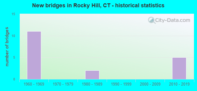
- New bridges - historical statistics
- 111960-1969
- 21980-1989
- 52010-2019

- Reconstructed bridges - Historical Statistics
- 11980-1989
- 21990-1999
- 22000-2009


- Bridge Condition - Deck
- 28.6%Good
- 57.1%Satisfactory
- 14.3%Fair

- Bridge Condition - Superstructure
- 25.0%Very good
- 12.5%Good
- 37.5%Satisfactory
- 25.0%Fair

- Bridge Condition - Substructure
- 12.5%Very good
- 62.5%Good
- 25.0%Satisfactory

- Bridge Condition - Channel
- 40.0%Good
- 60.0%Satisfactory
Find on map >> Show street view
Structure Number: 1448, Location: INTERSECTION I-91&ROUTE99 (Lat: 41.680464, Lng: -72.653483), Route carried "on" structure: Interstate 91, Year Built: 1964, Year Reconstructed: 2000, Status: Open, Structure Length: 6.11m (20.05ft), Average Daily Traffic: 69,900 (year 2019), Truck Traffic: 9%, Average Future Daily Traffic: 103,864 (year 2039), Design Load: HS 20, Features Intersected: ROUTE 99
Minimum Vertical Clearance: 30+ m (98+ ft), Kilometerpoint: 50.968, Lanes on structure: 5, Lanes under structure: 4, Base Highway Network: Yes, Owner: State Highway Agency, Approaching Roadway Width: 22.9m (75.1ft), Skew: 4 degrees, Material/Design: Steel, Design/Construction: Stringer/Multi-beam, Number Of Spans In Main Unit: 3, Length of Maximum Span: 36.3m (119.1ft), Curb-To-Curb Width: 22.9m (75.1ft), Out-to-Out Width: 24.0m (78.7ft)
Condition: Deck: Satisfactory, Superstructure: Fair, Substructure: Satisfactory, Operating Rating: 63.5 metric tons, Method Used To Determine Operating Rating: Load Factor (LF), Inventory Rating: 38.1 metric tons, Method Used To Determine Inventory Rating: Load Factor (LF), Structural Evaluation: Somewhat better than minimum adequacy, Deck Geometry: Somewhat better than minimum adequacy, Underclear: Meets minimum limits, Approach Roadway Alignment: Equal to present desirable criteria, Designated Inspection Frequency: Every 24 months, Inspection Date: August 2021, Deck Structure Type: Concrete Cast-file-Place, Wearing Surface/Protective System: Wearing Surface: Bituminous, Membrane: Built-up
Find on map >> Show street view
Structure Number: 1449, Location: 0.44MI N OF UP ORCHARD ST (Lat: 41.680831, Lng: -72.653664), Route carried "on" structure: Interstate 91, Year Built: 1964, Year Reconstructed: 2000, Status: Open, Structure Length: 6.61m (21.69ft), Average Daily Traffic: 71,900 (year 2019), Truck Traffic: 9%, Average Future Daily Traffic: 106,836 (year 2039), Design Load: H 20, Features Intersected: ROUTE 99
Minimum Vertical Clearance: 30+ m (98+ ft), Kilometerpoint: 50.984, Lanes on structure: 5, Lanes under structure: 4, Base Highway Network: Yes, Owner: State Highway Agency, Approaching Roadway Width: 22.9m (75.1ft), Skew: 4 degrees, Material/Design: Steel, Design/Construction: Stringer/Multi-beam, Number Of Spans In Main Unit: 3, Length of Maximum Span: 38.7m (127.0ft), Curb-To-Curb Width: 22.9m (75.1ft), Out-to-Out Width: 24.0m (78.7ft)
Condition: Deck: Satisfactory, Superstructure: Fair, Substructure: Good, Operating Rating: 62.7 metric tons, Method Used To Determine Operating Rating: Load Factor (LF), Inventory Rating: 37.6 metric tons, Method Used To Determine Inventory Rating: Load Factor (LF), Structural Evaluation: Somewhat better than minimum adequacy, Deck Geometry: Somewhat better than minimum adequacy, Underclear: Meets minimum limits, Approach Roadway Alignment: Equal to present desirable criteria, Designated Inspection Frequency: Every 24 months, Inspection Date: August 2021, Deck Structure Type: Concrete Cast-file-Place, Wearing Surface/Protective System: Wearing Surface: Bituminous
Find on map >> Show street view
Structure Number: 3031, Location: 1.19MI SOUTH JCT I91&RT99 (Lat: 41.666322, Lng: -72.665856), Route carried "on" structure: City street , Year Built: 1964, Year Reconstructed: 1994, Status: Open, Structure Length: 16.95m (55.61ft), Average Daily Traffic: 2,328 (year 2014), Truck Traffic: 3%, Average Future Daily Traffic: 3,459 (year 2034), Design Load: HS 20, Features Intersected: INTERSTATE-91, Facility Carried by Structure: GILBERT AVENUE
Minimum Vertical Clearance: 30+ m (98+ ft), Kilometerpoint: 1.625, Lanes on structure: 2, Lanes under structure: 8, Owner: State Highway Agency, Approaching Roadway Width: 9.1m (29.9ft), Skew: 5 degrees, Material/Design: Steel continuous, Design/Construction: Stringer/Multi-beam, Number Of Spans In Main Unit: 3, Number Of Approach Spans: 2, Length of Maximum Span: 42.7m (140.1ft), Curb or Sidewalk Widths: Left: 0.5m (1.6ft), Right: 1.7m (5.6ft), Curb-To-Curb Width: 9.1m (29.9ft), Out-to-Out Width: 12.0m (39.4ft)
Condition: Deck: Fair, Superstructure: Satisfactory, Substructure: Good, Channel: Good, Operating Rating: 92.4 metric tons, Method Used To Determine Operating Rating: Load Factor (LF), Inventory Rating: 55.5 metric tons, Method Used To Determine Inventory Rating: Load Factor (LF), Structural Evaluation: Equal to present minimum criteria, Deck Geometry: Meets minimum limits, Underclear: Somewhat better than minimum adequacy, Approach Roadway Alignment: Equal to present desirable criteria, Designated Inspection Frequency: Every 24 months, Inspection Date: June 2020, Deck Structure Type: Concrete Cast-file-Place, Wearing Surface/Protective System: Wearing Surface: Bituminous, Membrane: Preformed Fabric, Deck Protection: Epoxy Coated Reinforcing
Find on map >> Show street view
Structure Number: 3161, Location: .07 MI NO OF BROOK ST INT (Lat: 41.643081, Lng: -72.677253), Route carried "on" structure: State highway 3, Year Built: 1965, Year Reconstructed: 1990, Status: Open, Structure Length: 14.02m (46.00ft), Average Daily Traffic: 16,500 (year 2018), Truck Traffic: 5%, Average Future Daily Traffic: 24,517 (year 2038), Design Load: HS 20, Features Intersected: I-91 & DIVIDEND BROOK
Minimum Vertical Clearance: 30+ m (98+ ft), Kilometerpoint: 9.801, Lanes on structure: 4, Lanes under structure: 8, Owner: State Highway Agency, Approaching Roadway Width: 15.9m (52.2ft), Skew: 4 degrees, Material/Design: Steel continuous, Design/Construction: Stringer/Multi-beam, Number Of Spans In Main Unit: 3, Number Of Approach Spans: 2, Length of Maximum Span: 36.0m (118.1ft), Curb or Sidewalk Widths: Left: 0.0m, Right: 1.7m (5.6ft), Curb-To-Curb Width: 15.9m (52.2ft), Out-to-Out Width: 18.5m (60.7ft)
Condition: Deck: Satisfactory, Superstructure: Satisfactory, Substructure: Good, Channel: Good, Operating Rating: 66.6 metric tons, Method Used To Determine Operating Rating: Load Factor (LF), Inventory Rating: 39.9 metric tons, Method Used To Determine Inventory Rating: Load Factor (LF), Structural Evaluation: Equal to present minimum criteria, Deck Geometry: Meets minimum limits, Underclear: Somewhat better than minimum adequacy, Approach Roadway Alignment: Equal to present desirable criteria, Designated Inspection Frequency: Every 24 months, Inspection Date: March 2021, Deck Structure Type: Concrete Cast-file-Place, Wearing Surface/Protective System: Wearing Surface: Bituminous, Membrane: Preformed Fabric, Deck Protection: Epoxy Coated Reinforcing
Find on map >> Show street view
Structure Number: 3162, Location: .3MI (EAST) OF JCT RTE 3 (Lat: 41.650653, Lng: -72.672333), Route carried "on" structure: State highway 411, Year Built: 1965, Year Reconstructed: 1990, Status: Open, Structure Length: 11.25m (36.91ft), Average Daily Traffic: 19,300 (year 2018), Truck Traffic: 5%, Average Future Daily Traffic: 28,678 (year 2038), Design Load: HS 20, Features Intersected: INTERSTATE-91 & NB RAMP
Minimum Vertical Clearance: 30+ m (98+ ft), Kilometerpoint: 0.483, Lanes on structure: 5, Lanes under structure: 8, Owner: State Highway Agency, Approaching Roadway Width: 19.5m (64.0ft), Skew: 2 degrees, Material/Design: Steel, Design/Construction: Stringer/Multi-beam, Number Of Spans In Main Unit: 5, Length of Maximum Span: 31.1m (102.0ft), Curb or Sidewalk Widths: Left: 2.0m (6.6ft), Right: 0.0m, Curb-To-Curb Width: 19.5m (64.0ft), Out-to-Out Width: 22.5m (73.8ft)
Condition: Deck: Satisfactory, Superstructure: Satisfactory, Substructure: Satisfactory, Operating Rating: 69.5 metric tons, Method Used To Determine Operating Rating: Load Factor (LF), Inventory Rating: 41.7 metric tons, Method Used To Determine Inventory Rating: Load Factor (LF), Structural Evaluation: Equal to present minimum criteria, Deck Geometry: Meets minimum limits, Underclear: Somewhat better than minimum adequacy, Approach Roadway Alignment: Equal to present desirable criteria, Designated Inspection Frequency: Every 24 months, Inspection Date: April 2021, Deck Structure Type: Concrete Cast-file-Place, Wearing Surface/Protective System: Wearing Surface: Bituminous, Membrane: Preformed Fabric
Find on map >> Show street view
Structure Number: 3163, Location: 0.4 MILE EAST OF ROUTE 3 (Lat: 41.659058, Lng: -72.671161), Route carried "on" structure: State highway 160, Year Built: 2019, Status: Open, Structure Length: 4.29m (14.07ft), Average Daily Traffic: 9,400 (year 2018), Truck Traffic: 3%, Average Future Daily Traffic: 13,967 (year 2038), Design Load: HS 20, Features Intersected: INTERSTATE-91 SOUTHBOUND
Minimum Vertical Clearance: 30+ m (98+ ft), Kilometerpoint: 6.019, Lanes on structure: 2, Lanes under structure: 4, Owner: State Highway Agency, Approaching Roadway Width: 9.4m (30.8ft), Skew: 2 degrees, Material/Design: Steel, Design/Construction: Stringer/Multi-beam, Number Of Spans In Main Unit: 1, Length of Maximum Span: 41.3m (135.5ft), Curb or Sidewalk Widths: Left: 0.0m, Right: 1.5m (4.9ft), Curb-To-Curb Width: 9.8m (32.2ft), Out-to-Out Width: 12.2m (40.0ft)
Condition: Deck: Good, Superstructure: Very good, Substructure: Good, Operating Rating: 48.9 metric tons, Method Used To Determine Operating Rating: Load and Resistance Factor Rating (LRFR) rating reported by rating factor(RF) method using HL-93 loadings, Inventory Rating: 37.6 metric tons, Method Used To Determine Inventory Rating: Load and Resistance Factor Rating (LRFR) rating reported by rating factor(RF) method using HL-93 loadings, Structural Evaluation: Better than present minimum criteria, Deck Geometry: Meets minimum limits, Underclear: Superior to present desirable criteria, Approach Roadway Alignment: Equal to present desirable criteria, Designated Inspection Frequency: Every 24 months, Inspection Date: May 2020, Deck Structure Type: Concrete Cast-file-Place, Wearing Surface/Protective System: Wearing Surface: Bituminous, Membrane: Other, Deck Protection: Epoxy Coated Reinforcing
Find on map >> Show street view
Structure Number: 3164, Location: 1.69 MI W OF RTE 99 JUNCT (Lat: 41.659219, Lng: -72.669828), Route carried "on" structure: State highway 160, Year Built: 2019, Status: Open, Structure Length: 4.29m (14.07ft), Average Daily Traffic: 9,400 (year 2018), Truck Traffic: 5%, Average Future Daily Traffic: 13,967 (year 2038), Design Load: HS 20, Features Intersected: INTERSTATE-91 NORTHBOUND
Minimum Vertical Clearance: 30+ m (98+ ft), Kilometerpoint: 6.116, Lanes on structure: 2, Lanes under structure: 4, Owner: State Highway Agency, Approaching Roadway Width: 9.3m (30.5ft), Skew: 2 degrees, Material/Design: Steel, Design/Construction: Stringer/Multi-beam, Number Of Spans In Main Unit: 1, Length of Maximum Span: 41.3m (135.5ft), Curb or Sidewalk Widths: Left: 0.0m, Right: 1.5m (4.9ft), Curb-To-Curb Width: 9.8m (32.2ft), Out-to-Out Width: 12.2m (40.0ft)
Condition: Deck: Good, Superstructure: Very good, Substructure: Good, Operating Rating: 48.9 metric tons, Method Used To Determine Operating Rating: Load and Resistance Factor Rating (LRFR) rating reported by rating factor(RF) method using HL-93 loadings, Inventory Rating: 37.6 metric tons, Method Used To Determine Inventory Rating: Load and Resistance Factor Rating (LRFR) rating reported by rating factor(RF) method using HL-93 loadings, Structural Evaluation: Better than present minimum criteria, Deck Geometry: Meets minimum limits, Underclear: Somewhat better than minimum adequacy, Approach Roadway Alignment: Equal to present desirable criteria, Designated Inspection Frequency: Every 24 months, Inspection Date: May 2020, Deck Structure Type: Concrete Cast-file-Place, Wearing Surface/Protective System: Wearing Surface: Bituminous, Membrane: Other, Deck Protection: Other
Find on map >> Show street view
Structure Number: 6081, Location: 0.2 MI S OF FRANCE STREET (Lat: 41.645889, Lng: -72.688164), Route carried "on" structure: City street , Year Built: 1980, Status: Open, Structure Length: 1.04m (3.41ft), Average Daily Traffic: 1,336 (year 2020), Truck Traffic: 7%, Average Future Daily Traffic: 1,985 (year 2040), Features Intersected: BROOK, Facility Carried by Structure: WOODFIELD CROSSING
Minimum Vertical Clearance: 30+ m (98+ ft), Kilometerpoint: 0.644, Lanes on structure: 2, Owner: Town or Township Highway Agency, Approaching Roadway Width: 9.0m (29.5ft), Skew: 1 degrees, Material/Design: Steel, Design/Construction: Culvert, Number Of Spans In Main Unit: 3, Length of Maximum Span: 2.7m (8.9ft), Curb or Sidewalk Widths: Left: 1.2m (3.9ft), Right: 0.0m
Condition: Channel: Satisfactory, Culverts: Satisfactory, Structural Evaluation: Equal to present minimum criteria, Waterway Adequacy: Better than present minimum criteria, Approach Roadway Alignment: Equal to present desirable criteria, Designated Inspection Frequency: Every 24 months, Inspection Date: April 2020
Find on map >> Show street view
Structure Number: 7002, Location: 390 FT W OF ROUTE 99 (Lat: 41.677672, Lng: -72.653206), Route carried "on" structure: City street , Year Built: 1989, Status: Open, Structure Length: 0.82m (2.69ft), Average Daily Traffic: 310 (year 2020), Truck Traffic: 2%, Average Future Daily Traffic: 461 (year 2040), Features Intersected: VALLEY BROOK, Facility Carried by Structure: WATERCHASE DRIVE
Minimum Vertical Clearance: 30+ m (98+ ft), Kilometerpoint: 0.080, Lanes on structure: 2, Owner: Town or Township Highway Agency, Approaching Roadway Width: 9.8m (32.2ft), Skew: 4 degrees, Material/Design: Concrete, Design/Construction: Culvert, Number Of Spans In Main Unit: 2, Length of Maximum Span: 4.0m (13.1ft), Curb or Sidewalk Widths: Left: 1.2m (3.9ft), Right: 1.2m (3.9ft)
Condition: Channel: Satisfactory, Culverts: Satisfactory, Inventory Rating: 70.5 metric tons, Method Used To Determine Inventory Rating: No rating analysis performed, Structural Evaluation: Equal to present minimum criteria, Waterway Adequacy: Better than present minimum criteria, Approach Roadway Alignment: Better than present minimum criteria, Designated Inspection Frequency: Every 24 months, Inspection Date: April 2020
Find on map >> Show street view
Structure Number: 7003, Location: 0.2 MI S OF I-91 (Lat: 41.685000, Lng: -72.650278), Route carried "on" structure: City street , Year Built: 2014, Status: Open, Structure Length: 1.22m (4.00ft), Average Daily Traffic: 2,922 (year 2020), Truck Traffic: 1%, Average Future Daily Traffic: 4,342 (year 2040), Design Load: HL 93, Features Intersected: GOFF BROOK, Facility Carried by Structure: OLD MAIN STREET
Minimum Vertical Clearance: 30+ m (98+ ft), Kilometerpoint: 2.543, Lanes on structure: 2, Owner: Town or Township Highway Agency, Approaching Roadway Width: 7.9m (25.9ft), Material/Design: Concrete, Design/Construction: Arch - Deck, Number Of Spans In Main Unit: 1, Length of Maximum Span: 12.2m (40.0ft), Curb or Sidewalk Widths: Left: 0.2m (0.7ft), Right: 1.8m (5.9ft), Curb-To-Curb Width: 7.9m (25.9ft), Out-to-Out Width: 10.8m (35.4ft)
Condition: Superstructure: Good, Substructure: Very good, Channel: Satisfactory, Operating Rating: 55.1 metric tons, Method Used To Determine Operating Rating: Load and Resistance Factor Rating (LRFR) rating reported by rating factor(RF) method using HL-93 loadings, Inventory Rating: 38.9 metric tons, Method Used To Determine Inventory Rating: Load and Resistance Factor Rating (LRFR) rating reported by rating factor(RF) method using HL-93 loadings, Structural Evaluation: Better than present minimum criteria, Deck Geometry: High priority of corrective action, Waterway Adequacy: Better than present minimum criteria, Approach Roadway Alignment: Equal to present desirable criteria, Designated Inspection Frequency: Every 24 months, Inspection Date: April 2020
Find on map >> Show street view
Structure Number: 1448, Location: INTERSECTION I-91&ROUTE99 (Lat: 41.680464, Lng: -72.653483), Route carried "under" structure: State highway 99, Year Built: 1964, Structure Length: 0. m, Average Daily Traffic: 25,500 (year 2018), Truck Traffic: 5%, Features Intersected: ROUTE 99, Facility Carried by Structure: INTERSTATE-91 NB
Minimum Vertical Clearance: 4.45m (14.60ft), Kilometerpoint: 11.652, Lanes on structure: 5, Lanes under structure: 4, Material/Design: Steel, Design/Construction: Stringer/Multi-beam, Length of Maximum Span: 36.3m (119.1ft)
Find on map >> Show street view
Structure Number: 1449, Location: 0.44MI N OF UP ORCHARD ST (Lat: 41.680831, Lng: -72.653664), Route carried "under" structure: State highway 99, Year Built: 1964, Structure Length: 0. m, Average Daily Traffic: 25,500 (year 2018), Truck Traffic: 5%, Features Intersected: ROUTE 99, Facility Carried by Structure: INTERSTATE-91 SB
Minimum Vertical Clearance: 4.39m (14.40ft), Kilometerpoint: 11.684, Lanes on structure: 5, Lanes under structure: 4, Material/Design: Steel, Design/Construction: Stringer/Multi-beam, Length of Maximum Span: 38.7m (127.0ft)
Find on map >> Show street view
Structure Number: 3025, Location: 0.4 MILE SOUTH OF EXIT 24 (Lat: 41.675333, Lng: -72.658650), Route carried "under" structure: Interstate 91, Year Built: 1964, Structure Length: 0. m, Average Daily Traffic: 149,900 (year 2018), Truck Traffic: 9%, Features Intersected: INTERSTATE 91, Facility Carried by Structure: ORCHARD STREET
Minimum Vertical Clearance: 5.16m (16.93ft), Kilometerpoint: 50.276, Lanes on structure: 2, Lanes under structure: 8, Material/Design: Steel continuous, Design/Construction: Stringer/Multi-beam, Length of Maximum Span: 37.6m (123.4ft)
Find on map >> Show street view
Structure Number: 3031, Location: 1.19MI SOUTH JCT I91&RT99 (Lat: 41.666322, Lng: -72.665856), Route carried "under" structure: Interstate 91, Year Built: 1964, Structure Length: 0. m, Average Daily Traffic: 149,900 (year 2015), Truck Traffic: 14%, Features Intersected: INTERSTATE-91, Facility Carried by Structure: GILBERT AVENUE
Minimum Vertical Clearance: 5.44m (17.85ft), Kilometerpoint: 49.069, Lanes on structure: 2, Lanes under structure: 8, Material/Design: Steel continuous, Design/Construction: Stringer/Multi-beam, Length of Maximum Span: 42.7m (140.1ft)
Find on map >> Show street view
Structure Number: 3161, Location: .07 MI NO OF BROOK ST INT (Lat: 41.643081, Lng: -72.677253), Route carried "under" structure: Interstate 91, Year Built: 1965, Structure Length: 0. m, Average Daily Traffic: 151,500 (year 2015), Truck Traffic: 9%, Features Intersected: I-91 & DIVIDEND BROOK, Facility Carried by Structure: ROUTE 3
Minimum Vertical Clearance: 5.28m (17.32ft), Kilometerpoint: 46.301, Lanes on structure: 4, Lanes under structure: 8, Material/Design: Steel continuous, Design/Construction: Stringer/Multi-beam, Length of Maximum Span: 36.0m (118.1ft)
Find on map >> Show street view
Structure Number: 3162, Location: .3MI (EAST) OF JCT RTE 3 (Lat: 41.650653, Lng: -72.672333), Route carried "under" structure: Interstate 91, Year Built: 1965, Structure Length: 0. m, Average Daily Traffic: 139,000 (year 2015), Truck Traffic: 9%, Features Intersected: INTERSTATE-91 & NB RAMP, Facility Carried by Structure: SSR 411(WEST ST)
Minimum Vertical Clearance: 5.44m (17.85ft), Kilometerpoint: 47.299, Lanes on structure: 5, Lanes under structure: 9, Material/Design: Steel, Design/Construction: Stringer/Multi-beam, Length of Maximum Span: 31.1m (102.0ft)
Find on map >> Show street view
Structure Number: 3163, Location: 0.4 MILE EAST OF ROUTE 3 (Lat: 41.659058, Lng: -72.671161), Route carried "under" structure: Interstate 91, Year Built: 2019, Structure Length: 0. m, Average Daily Traffic: 75,100 (year 2015), Truck Traffic: 9%, Features Intersected: INTERSTATE-91 SOUTHBOUND, Facility Carried by Structure: ROUTE 160
Minimum Vertical Clearance: 6.53m (21.42ft), Kilometerpoint: 48.200, Lanes on structure: 2, Lanes under structure: 4, Material/Design: Steel, Design/Construction: Stringer/Multi-beam, Length of Maximum Span: 41.3m (135.5ft)
Find on map >> Show street view
Structure Number: 3164, Location: 1.69 MI W OF RTE 99 JUNCT (Lat: 41.659219, Lng: -72.669828), Route carried "under" structure: Interstate 91, Year Built: 2019, Structure Length: 0. m, Average Daily Traffic: 73,300 (year 2015), Truck Traffic: 9%, Features Intersected: INTERSTATE-91 NORTHBOUND, Facility Carried by Structure: ROUTE 160
Minimum Vertical Clearance: 5.92m (19.42ft), Kilometerpoint: 48.264, Lanes on structure: 2, Lanes under structure: 4, Material/Design: Steel, Design/Construction: Stringer/Multi-beam, Length of Maximum Span: 41.3m (135.5ft)