Bridge Statistics for Rocky River, Ohio (OH)
Condition, Traffic, Stress, Structural Evaluation, Project Costs
- National Bridge Inventory (NBI) Statistics
- 27Number of bridges
- 515ft / 157mTotal length
- $8,030,000Total costs
- 876,795Total average daily traffic
- 44,102Total average daily truck traffic
- National Bridge Inventory (NBI) Registered Bridges for Rocky River
- No street view available for this location
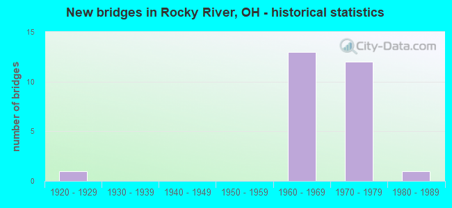
- New bridges - historical statistics
- 11920-1929
- 131960-1969
- 121970-1979
- 11980-1989

- Reconstructed bridges - Historical Statistics
- 11970-1979
- 01980-1989
- 41990-1999
- 12000-2009


- Bridge Condition - Deck
- 7.1%Very good
- 42.9%Good
- 35.7%Satisfactory
- 7.1%Fair
- 7.1%Poor

- Bridge Condition - Superstructure
- 57.1%Good
- 28.6%Satisfactory
- 7.1%Fair
- 7.1%Poor

- Bridge Condition - Substructure
- 14.3%Good
- 50.0%Satisfactory
- 21.4%Fair
- 14.3%Poor

- Bridge Condition - Channel
- 66.7%Very good
- 33.3%Satisfactory
Find on map >> Show street view
Structure Number: 1800604, Location: APPROX .5 MI W ROCKY RIV. (Lat: 41.483939, Lng: -81.837939), Route carried "on" structure: State highway 2, Year Built: 1964, Status: Open, Structure Length: 7.53m (24.70ft), Average Daily Traffic: 10,229 (year 2015), Truck Traffic: 4%, Average Future Daily Traffic: 14,198 (year 2035), Design Load: H 20, Features Intersected: US 6 WEST LAKE RD
Minimum Vertical Clearance: 30+ m (98+ ft), Kilometerpoint: 11.764, Lanes on structure: 1, Lanes under structure: 4, Owner: State Highway Agency, Approaching Roadway Width: 5.8m (19.0ft), Material/Design: Concrete continuous, Design/Construction: Box Beam or Girders - Multiple, Number Of Spans In Main Unit: 3, Length of Maximum Span: 35.4m (116.1ft), Curb-To-Curb Width: 5.8m (19.0ft), Out-to-Out Width: 5.8m (19.0ft)
Condition: Deck: Good, Superstructure: Satisfactory, Substructure: Satisfactory, Operating Rating: 51.8 metric tons, Method Used To Determine Operating Rating: Load Factor (LF) rating reported by rating factor (RF) method using MS18 loading, Inventory Rating: 32.4 metric tons, Method Used To Determine Inventory Rating: Load Factor (LF) rating reported by rating factor (RF) method using MS18 loading, Structural Evaluation: Equal to present minimum criteria, Deck Geometry: High priority of replacement, Underclear: Somewhat better than minimum adequacy, Approach Roadway Alignment: Equal to present desirable criteria, Designated Inspection Frequency: Every 12 months, Inspection Date: October 2021, Deck Structure Type: Concrete Cast-file-Place, Wearing Surface/Protective System: Wearing Surface: Integral Concrete
Find on map >> Show street view
Structure Number: 1800639, Location: 0.8 MI. W. OF JCT. SR 237 (Lat: 41.486761, Lng: -81.831769), Route carried "on" structure: US 6, Year Built: 1964, Year Reconstructed: 1997, Status: Open, Structure Length: 34.72m (113.91ft), Average Daily Traffic: 12,135 (year 2015), Truck Traffic: 2%, Average Future Daily Traffic: 16,843 (year 2035), Design Load: HS 20+Mod, Features Intersected: ROCKY RIVER,6A,YHT CLB L
Minimum Vertical Clearance: 30+ m (98+ ft), Kilometerpoint: 11.877, Lanes on structure: 4, Lanes under structure: 6, Base Highway Network: Yes, Owner: State Highway Agency, Approaching Roadway Width: 20.4m (66.9ft), Skew: 39 degrees, Material/Design: Steel continuous, Design/Construction: Stringer/Multi-beam, Number Of Spans In Main Unit: 8, Length of Maximum Span: 57.0m (187.0ft), Curb or Sidewalk Widths: Left: 1.5m (4.9ft), Right: 1.5m (4.9ft), Curb-To-Curb Width: 18.3m (60.0ft), Out-to-Out Width: 21.9m (71.9ft)
Condition: Deck: Good, Superstructure: Good, Substructure: Satisfactory, Channel: Very good, Operating Rating: 42.1 metric tons, Method Used To Determine Operating Rating: Load Factor (LF) rating reported by rating factor (RF) method using MS18 loading, Inventory Rating: 32.4 metric tons, Method Used To Determine Inventory Rating: Load Factor (LF) rating reported by rating factor (RF) method using MS18 loading, Structural Evaluation: Equal to present minimum criteria, Deck Geometry: Somewhat better than minimum adequacy, Underclear: High priority of corrective action, Waterway Adequacy: Superior to present desirable criteria, Approach Roadway Alignment: Equal to present desirable criteria, Length Of Structure Improvement: 36.58m (120.01ft), Designated Inspection Frequency: Every 12 months, Underwater Inspection Frequency: Every 60 months, Inspection Date: September 2021, Underwater Inspection Date: July 2020, Roadway Improvement Cost: $300,000, Total Project Cost: $3,900,000, Deck Structure Type: Concrete Cast-file-Place, Wearing Surface/Protective System: Wearing Surface: Latex Concrete, Deck Protection: Epoxy Coated Reinforcing
Find on map >> Show street view
Structure Number: 1801074, Location: 400FT. E. USR20 (Lat: 41.482469, Lng: -81.832519), Route carried "on" structure: US 6A, Year Built: 1980, Status: Open, Structure Length: 19.51m (64.01ft), Average Daily Traffic: 15,856 (year 2015), Truck Traffic: 17%, Average Future Daily Traffic: 22,008 (year 2035), Design Load: HS 20+Mod, Features Intersected: ROCKY RIVER
Minimum Vertical Clearance: 30+ m (98+ ft), Kilometerpoint: 0.676, Lanes on structure: 4, Owner: State Highway Agency, Approaching Roadway Width: 19.5m (64.0ft), Material/Design: Steel, Design/Construction: Girder and Floorbeam System, Number Of Spans In Main Unit: 3, Length of Maximum Span: 80.8m (265.1ft), Curb or Sidewalk Widths: Left: 2.1m (6.9ft), Right: 2.1m (6.9ft), Curb-To-Curb Width: 22.6m (74.1ft), Out-to-Out Width: 24.4m (80.1ft)
Condition: Deck: Satisfactory, Superstructure: Satisfactory, Substructure: Good, Channel: Very good, Operating Rating: 42.1 metric tons, Method Used To Determine Operating Rating: Load Factor (LF) rating reported by rating factor (RF) method using MS18 loading, Inventory Rating: 32.4 metric tons, Method Used To Determine Inventory Rating: Load Factor (LF) rating reported by rating factor (RF) method using MS18 loading, Structural Evaluation: Equal to present minimum criteria, Deck Geometry: Superior to present desirable criteria, Waterway Adequacy: Equal to present desirable criteria, Approach Roadway Alignment: Equal to present desirable criteria, Designated Inspection Frequency: Every 12 months, Inspection Date: September 2021, Deck Structure Type: Concrete Cast-file-Place, Wearing Surface/Protective System: Wearing Surface: Integral Concrete, Membrane: Epoxy
Find on map >> Show street view
Structure Number: 1801112, Location: APPROX .5MI W ROCKY RIVER (Lat: 41.483350, Lng: -81.837769), Route carried "on" structure: State highway 2, Year Built: 1964, Status: Open, Structure Length: 5.64m (18.50ft), Average Daily Traffic: 10,229 (year 2015), Truck Traffic: 4%, Average Future Daily Traffic: 14,198 (year 2035), Features Intersected: US6A EB(CUY-6A-0003)
Minimum Vertical Clearance: 30+ m (98+ ft), Kilometerpoint: 11.764, Lanes on structure: 1, Lanes under structure: 1, Owner: State Highway Agency, Approaching Roadway Width: 73.2m (240.2ft), Material/Design: Concrete continuous, Design/Construction: Box Beam or Girders - Multiple, Number Of Spans In Main Unit: 3, Length of Maximum Span: 21.3m (69.9ft), Curb or Sidewalk Widths: Left: 0.7m (2.3ft), Right: 0.7m (2.3ft), Curb-To-Curb Width: 5.9m (19.4ft), Out-to-Out Width: 7.2m (23.6ft)
Condition: Deck: Good, Superstructure: Satisfactory, Substructure: Good, Operating Rating: 42.1 metric tons, Method Used To Determine Operating Rating: Load Factor (LF) rating reported by rating factor (RF) method using MS18 loading, Inventory Rating: 32.4 metric tons, Method Used To Determine Inventory Rating: Load Factor (LF) rating reported by rating factor (RF) method using MS18 loading, Structural Evaluation: Equal to present minimum criteria, Deck Geometry: High priority of replacement, Underclear: High priority of corrective action, Approach Roadway Alignment: Equal to present desirable criteria, Designated Inspection Frequency: Every 12 months, Inspection Date: October 2021, Deck Structure Type: Concrete Cast-file-Place, Wearing Surface/Protective System: Wearing Surface: Integral Concrete
Find on map >> Show street view
Structure Number: 180773, Location: IR90 AND JCT SR254 (Lat: 41.472531, Lng: -81.857211), Route carried "on" structure: State highway 2, Year Built: 1977, Status: Open, Structure Length: 7.59m (24.90ft), Average Daily Traffic: 9,734 (year 2015), Truck Traffic: 4%, Average Future Daily Traffic: 13,511 (year 2035), Design Load: HS 20+Mod, Features Intersected: IR-90(CUY-90-0595)
Minimum Vertical Clearance: 30+ m (98+ ft), Kilometerpoint: 9.608, Lanes on structure: 4, Lanes under structure: 6, Owner: State Highway Agency, Approaching Roadway Width: 16.5m (54.1ft), Skew: 4 degrees, Material/Design: Steel continuous, Design/Construction: Stringer/Multi-beam, Number Of Spans In Main Unit: 3, Length of Maximum Span: 28.7m (94.2ft), Curb or Sidewalk Widths: Left: 1.8m (5.9ft), Right: 1.8m (5.9ft), Curb-To-Curb Width: 16.5m (54.1ft), Out-to-Out Width: 20.7m (67.9ft)
Condition: Deck: Satisfactory, Superstructure: Satisfactory, Substructure: Fair, Operating Rating: 42.1 metric tons, Method Used To Determine Operating Rating: Load and Resistance Factor Rating (LRFR) rating reported by rating factor(RF) method using HL-93 loadings, Inventory Rating: 32.4 metric tons, Method Used To Determine Inventory Rating: Load and Resistance Factor Rating (LRFR) rating reported by rating factor(RF) method using HL-93 loadings, Structural Evaluation: Somewhat better than minimum adequacy, Deck Geometry: Meets minimum limits, Underclear: High priority of corrective action, Approach Roadway Alignment: Equal to present desirable criteria, Designated Inspection Frequency: Every 12 months, Inspection Date: October 2021, Deck Structure Type: Concrete Cast-file-Place, Wearing Surface/Protective System: Wearing Surface: Integral Concrete, Deck Protection: Cathodic Protection
Find on map >> Show street view
Structure Number: 1807749, Location: .12 MI E OF JCT SR254 (Lat: 41.472161, Lng: -81.855100), Route carried "on" structure: Ramp City street WestW, Year Built: 1975, Status: Open, Structure Length: 7.13m (23.39ft), Average Daily Traffic: 19,405 (year 2002), Truck Traffic: 3%, Average Future Daily Traffic: 118,288 (year 2022), Design Load: HS 20, Features Intersected: IR-90 (Westway Dr), Facility Carried by Structure: WESTWAY DRIVE
Minimum Vertical Clearance: 30+ m (98+ ft), Kilometerpoint: 9.769, Lanes on structure: 2, Lanes under structure: 6, Owner: State Highway Agency, Approaching Roadway Width: 8.5m (27.9ft), Skew: 5 degrees, Material/Design: Steel continuous, Design/Construction: Stringer/Multi-beam, Number Of Spans In Main Unit: 2, Length of Maximum Span: 35.1m (115.2ft), Curb or Sidewalk Widths: Left: 0.6m (2.0ft), Right: 0.6m (2.0ft), Curb-To-Curb Width: 8.5m (27.9ft), Out-to-Out Width: 10.4m (34.1ft)
Condition: Deck: Good, Superstructure: Good, Substructure: Fair, Operating Rating: 42.1 metric tons, Method Used To Determine Operating Rating: Load Factor (LF) rating reported by rating factor (RF) method using MS18 loading, Inventory Rating: 32.4 metric tons, Method Used To Determine Inventory Rating: Load Factor (LF) rating reported by rating factor (RF) method using MS18 loading, Structural Evaluation: Somewhat better than minimum adequacy, Deck Geometry: High priority of corrective action, Underclear: High priority of corrective action, Approach Roadway Alignment: Equal to present desirable criteria, Designated Inspection Frequency: Every 12 months, Inspection Date: September 2021, Deck Structure Type: Concrete Cast-file-Place, Wearing Surface/Protective System: Wearing Surface: Integral Concrete, Deck Protection: Cathodic Protection
Find on map >> Show street view
Structure Number: 1807757, Location: .26 MI E OF JCT SR254 (Lat: 41.471839, Lng: -81.852400), Route carried "on" structure: County highway C0260, Year Built: 1977, Year Reconstructed: 2001, Status: Open, Structure Length: 3.93m (12.89ft), Average Daily Traffic: 16,259 (year 2015), Truck Traffic: 2%, Average Future Daily Traffic: 22,567 (year 2035), Design Load: HS 20+Mod, Features Intersected: IR-90 (WAGAR), Facility Carried by Structure: WAGAR RD - CR260
Minimum Vertical Clearance: 30+ m (98+ ft), Kilometerpoint: 4.484, Lanes on structure: 4, Lanes under structure: 6, Owner: State Highway Agency, Approaching Roadway Width: 19.5m (64.0ft), Material/Design: Steel continuous, Design/Construction: Stringer/Multi-beam, Number Of Spans In Main Unit: 2, Length of Maximum Span: 18.9m (62.0ft), Curb or Sidewalk Widths: Left: 1.8m (5.9ft), Right: 1.8m (5.9ft), Curb-To-Curb Width: 19.5m (64.0ft), Out-to-Out Width: 23.8m (78.1ft)
Condition: Deck: Satisfactory, Superstructure: Good, Substructure: Satisfactory, Operating Rating: 42.1 metric tons, Method Used To Determine Operating Rating: Load Factor (LF) rating reported by rating factor (RF) method using MS18 loading, Inventory Rating: 32.4 metric tons, Method Used To Determine Inventory Rating: Load Factor (LF) rating reported by rating factor (RF) method using MS18 loading, Structural Evaluation: Equal to present minimum criteria, Deck Geometry: Better than present minimum criteria, Underclear: High priority of corrective action, Approach Roadway Alignment: Equal to present desirable criteria, Length Of Structure Improvement: 3.96m (12.99ft), Designated Inspection Frequency: Every 12 months, Inspection Date: October 2021, Bridge Improvement Cost: $495,000, Roadway Improvement Cost: $55,000, Total Project Cost: $550,000, Deck Structure Type: Concrete Cast-file-Place, Wearing Surface/Protective System: Wearing Surface: Monolithic Concrete, Membrane: Built-up
Find on map >> Show street view
Structure Number: 1807765, Location: .53 MI E OF JCT SR254 (Lat: 41.471981, Lng: -81.847281), Route carried "on" structure: City street NTHVW, Year Built: 1977, Year Reconstructed: 2001, Status: Open, Structure Length: 6.83m (22.41ft), Average Daily Traffic: 6,702 (year 2015), Truck Traffic: 5%, Average Future Daily Traffic: 118,288 (year 2035), Design Load: H 20, Features Intersected: I-90, Facility Carried by Structure: NORTHVIEW RD
Minimum Vertical Clearance: 30+ m (98+ ft), Kilometerpoint: 0.000, Lanes on structure: 2, Lanes under structure: 6, Owner: State Highway Agency, Approaching Roadway Width: 7.9m (25.9ft), Material/Design: Steel continuous, Design/Construction: Stringer/Multi-beam, Number Of Spans In Main Unit: 4, Length of Maximum Span: 19.8m (65.0ft), Curb or Sidewalk Widths: Left: 1.8m (5.9ft), Right: 1.8m (5.9ft), Curb-To-Curb Width: 7.9m (25.9ft), Out-to-Out Width: 12.2m (40.0ft)
Condition: Deck: Satisfactory, Superstructure: Good, Substructure: Satisfactory, Operating Rating: 58.3 metric tons, Method Used To Determine Operating Rating: Load and Resistance Factor Rating (LRFR) rating reported by rating factor(RF) method using HL-93 loadings, Inventory Rating: 45.4 metric tons, Method Used To Determine Inventory Rating: Load and Resistance Factor Rating (LRFR) rating reported by rating factor(RF) method using HL-93 loadings, Structural Evaluation: Equal to present minimum criteria, Deck Geometry: High priority of corrective action, Underclear: High priority of corrective action, Approach Roadway Alignment: Equal to present desirable criteria, Length Of Structure Improvement: 6.83m (22.41ft), Designated Inspection Frequency: Every 12 months, Inspection Date: March 2021, Bridge Improvement Cost: $432,000, Roadway Improvement Cost: $48,000, Total Project Cost: $480,000, Deck Structure Type: Concrete Cast-file-Place, Wearing Surface/Protective System: Wearing Surface: Monolithic Concrete, Membrane: Built-up
Find on map >> Show street view
Structure Number: 1807781, Location: .72 MI E OF JCT SR254 (Lat: 41.471981, Lng: -81.843539), Route carried "on" structure: City street LCKVW, Year Built: 1977, Status: Open, Structure Length: 6.89m (22.60ft), Average Daily Traffic: 6,702 (year 2015), Truck Traffic: 5%, Average Future Daily Traffic: 118,288 (year 2035), Design Load: H 20, Features Intersected: I-90 (Lakview Ave), Facility Carried by Structure: LAKEVIEW AVE
Minimum Vertical Clearance: 30+ m (98+ ft), Kilometerpoint: 0.000, Lanes on structure: 2, Lanes under structure: 6, Owner: State Highway Agency, Approaching Roadway Width: 8.5m (27.9ft), Material/Design: Steel continuous, Design/Construction: Stringer/Multi-beam, Number Of Spans In Main Unit: 4, Length of Maximum Span: 19.8m (65.0ft), Curb or Sidewalk Widths: Left: 1.8m (5.9ft), Right: 1.8m (5.9ft), Curb-To-Curb Width: 8.5m (27.9ft), Out-to-Out Width: 12.8m (42.0ft)
Condition: Deck: Satisfactory, Superstructure: Good, Substructure: Satisfactory, Operating Rating: 51.8 metric tons, Method Used To Determine Operating Rating: Load and Resistance Factor Rating (LRFR) rating reported by rating factor(RF) method using HL-93 loadings, Inventory Rating: 38.9 metric tons, Method Used To Determine Inventory Rating: Load and Resistance Factor Rating (LRFR) rating reported by rating factor(RF) method using HL-93 loadings, Structural Evaluation: Equal to present minimum criteria, Deck Geometry: Meets minimum limits, Underclear: High priority of corrective action, Approach Roadway Alignment: Equal to present desirable criteria, Designated Inspection Frequency: Every 12 months, Inspection Date: March 2021, Deck Structure Type: Concrete Cast-file-Place, Wearing Surface/Protective System: Wearing Surface: Integral Concrete, Deck Protection: Cathodic Protection
Find on map >> Show street view
Structure Number: 1808508, Location: .21 MI W OF JCT US20 (Lat: 41.472311, Lng: -81.839531), Route carried "on" structure: Ramp Interstate 90, Year Built: 1969, Status: Open, Structure Length: 11.55m (37.89ft), Average Daily Traffic: 13,009 (year 2016), Truck Traffic: 2%, Average Future Daily Traffic: 18,056 (year 2036), Design Load: HS 20+Mod, Features Intersected: IR-90 MAINLINE
Minimum Vertical Clearance: 30+ m (98+ ft), Kilometerpoint: 10.987, Lanes on structure: 2, Lanes under structure: 6, Owner: State Highway Agency, Approaching Roadway Width: 11.0m (36.1ft), Skew: 9 degrees, Material/Design: Steel continuous, Design/Construction: Stringer/Multi-beam, Number Of Spans In Main Unit: 4, Length of Maximum Span: 35.1m (115.2ft), Curb-To-Curb Width: 11.0m (36.1ft), Out-to-Out Width: 14.6m (47.9ft)
Condition: Deck: Good, Superstructure: Good, Substructure: Poor, Operating Rating: 42.1 metric tons, Method Used To Determine Operating Rating: Load Factor (LF) rating reported by rating factor (RF) method using MS18 loading, Inventory Rating: 32.4 metric tons, Method Used To Determine Inventory Rating: Load Factor (LF) rating reported by rating factor (RF) method using MS18 loading, Structural Evaluation: Meets minimum limits, Deck Geometry: Better than present minimum criteria, Underclear: High priority of corrective action, Approach Roadway Alignment: Equal to present minimum criteria, Designated Inspection Frequency: Every 12 months, Inspection Date: March 2021, Deck Structure Type: Concrete Cast-file-Place, Wearing Surface/Protective System: Wearing Surface: Latex Concrete, Deck Protection: Cathodic Protection
Find on map >> Show street view
Structure Number: 1808516, Location: IR90 AND US20 JCT (Lat: 41.472111, Lng: -81.836281), Route carried "on" structure: US 20, Year Built: 1969, Year Reconstructed: 2005, Status: Open, Structure Length: 5.82m (19.09ft), Average Daily Traffic: 11,777 (year 2015), Truck Traffic: 6%, Average Future Daily Traffic: 16,346 (year 2035), Design Load: H 20, Features Intersected: CUY-90-0704(WOOSTER ROAD, Facility Carried by Structure: WOOSTER RD
Minimum Vertical Clearance: 30+ m (98+ ft), Kilometerpoint: 13.631, Lanes on structure: 4, Lanes under structure: 10, Owner: State Highway Agency, Approaching Roadway Width: 16.5m (54.1ft), Skew: 1 degrees, Material/Design: Steel continuous, Design/Construction: Stringer/Multi-beam, Number Of Spans In Main Unit: 2, Length of Maximum Span: 29.3m (96.1ft), Curb or Sidewalk Widths: Left: 1.8m (5.9ft), Right: 1.8m (5.9ft), Curb-To-Curb Width: 16.5m (54.1ft), Out-to-Out Width: 20.7m (67.9ft)
Condition: Deck: Good, Superstructure: Fair, Substructure: Fair, Operating Rating: 42.1 metric tons, Method Used To Determine Operating Rating: Load Factor (LF) rating reported by rating factor (RF) method using MS18 loading, Inventory Rating: 32.4 metric tons, Method Used To Determine Inventory Rating: Load Factor (LF) rating reported by rating factor (RF) method using MS18 loading, Structural Evaluation: Somewhat better than minimum adequacy, Deck Geometry: Meets minimum limits, Underclear: High priority of corrective action, Approach Roadway Alignment: Equal to present desirable criteria, Length Of Structure Improvement: 5.82m (19.09ft), Designated Inspection Frequency: Every 12 months, Inspection Date: Febuary 2021, Bridge Improvement Cost: $95,000, Roadway Improvement Cost: $5,000, Total Project Cost: $100,000, Deck Structure Type: Concrete Cast-file-Place, Wearing Surface/Protective System: Wearing Surface: Latex Concrete
Find on map >> Show street view
Structure Number: 180854, Location: .5 MI E OF JCT US20 (Lat: 41.471961, Lng: -81.826811), Route carried "on" structure: City street VLYVW, Year Built: 1971, Year Reconstructed: 2002, Status: Open, Structure Length: 7.62m (25.00ft), Average Daily Traffic: 10,217 (year 2015), Truck Traffic: 7%, Average Future Daily Traffic: 147,984 (year 2035), Design Load: H 20, Features Intersected: IR 90, Facility Carried by Structure: VALLEYVIEW DRIVE
Minimum Vertical Clearance: 30+ m (98+ ft), Kilometerpoint: 0.000, Lanes on structure: 2, Lanes under structure: 8, Owner: State Highway Agency, Approaching Roadway Width: 8.5m (27.9ft), Material/Design: Steel continuous, Design/Construction: Stringer/Multi-beam, Number Of Spans In Main Unit: 4, Length of Maximum Span: 23.5m (77.1ft), Curb or Sidewalk Widths: Left: 1.8m (5.9ft), Right: 1.8m (5.9ft), Curb-To-Curb Width: 8.5m (27.9ft), Out-to-Out Width: 12.8m (42.0ft)
Condition: Deck: Very good, Superstructure: Good, Substructure: Satisfactory, Operating Rating: 45.4 metric tons, Method Used To Determine Operating Rating: Load and Resistance Factor Rating (LRFR) rating reported by rating factor(RF) method using HL-93 loadings, Inventory Rating: 35.6 metric tons, Method Used To Determine Inventory Rating: Load and Resistance Factor Rating (LRFR) rating reported by rating factor(RF) method using HL-93 loadings, Structural Evaluation: Equal to present minimum criteria, Deck Geometry: Meets minimum limits, Underclear: High priority of corrective action, Approach Roadway Alignment: Equal to present desirable criteria, Designated Inspection Frequency: Every 12 months, Inspection Date: November 2021, Deck Structure Type: Concrete Cast-file-Place, Wearing Surface/Protective System: Wearing Surface: Latex Concrete
Find on map >> Show street view
Structure Number: 1810561, Location: 1.04 MI E JCT 1 90 (Lat: 41.482589, Lng: -81.838489), Route carried "on" structure: State highway 2, Year Built: 1964, Status: Open, Structure Length: 4.60m (15.09ft), Average Daily Traffic: 3,775 (year 2015), Truck Traffic: 4%, Average Future Daily Traffic: 5,240 (year 2035), Design Load: H 20, Features Intersected: (0704)NSC RR @ PARSONS C
Minimum Vertical Clearance: 30+ m (98+ ft), Kilometerpoint: 11.668, Lanes on structure: 2, Owner: State Highway Agency, Approaching Roadway Width: 11.3m (37.1ft), Skew: 29 degrees, Material/Design: Steel continuous, Design/Construction: Stringer/Multi-beam, Number Of Spans In Main Unit: 2, Length of Maximum Span: 25.6m (84.0ft), Curb or Sidewalk Widths: Left: 0.7m (2.3ft), Right: 0.7m (2.3ft), Curb-To-Curb Width: 10.1m (33.1ft), Out-to-Out Width: 11.3m (37.1ft)
Condition: Deck: Fair, Superstructure: Good, Substructure: Satisfactory, Operating Rating: 49.6 metric tons, Method Used To Determine Operating Rating: Load Factor (LF) rating reported by rating factor (RF) method using MS18 loading, Inventory Rating: 29.8 metric tons, Method Used To Determine Inventory Rating: Load Factor (LF) rating reported by rating factor (RF) method using MS18 loading, Structural Evaluation: Equal to present minimum criteria, Deck Geometry: Meets minimum limits, Underclear: Somewhat better than minimum adequacy, Approach Roadway Alignment: Equal to present minimum criteria, Designated Inspection Frequency: Every 12 months, Inspection Date: October 2021, Deck Structure Type: Concrete Cast-file-Place, Wearing Surface/Protective System: Wearing Surface: Integral Concrete
Find on map >> Show street view
Structure Number: 1830147, Location: 910 FT W OF ROCKY RVR DR (Lat: 41.471411, Lng: -81.823889), Route carried "on" structure: County highway 69, Year Built: 1925, Year Reconstructed: 1983, Status: Posted for load, Structure Length: 27.22m (89.30ft), Average Daily Traffic: 10,217 (year 2015), Truck Traffic: 7%, Average Future Daily Traffic: 14,181 (year 2035), Design Load: HS 20+Mod, Features Intersected: ROCKY RIVER, VALLEY PKWY
Minimum Vertical Clearance: 30+ m (98+ ft), Kilometerpoint: 13.792, Lanes on structure: 4, Owner: County Highway Agency, Approaching Roadway Width: 17.1m (56.1ft), Material/Design: Concrete, Design/Construction: Arch - Deck, Number Of Spans In Main Unit: 3, Number Of Approach Spans: 7, Length of Maximum Span: 67.1m (220.1ft), Curb or Sidewalk Widths: Left: 2.9m (9.5ft), Right: 2.9m (9.5ft), Curb-To-Curb Width: 17.1m (56.1ft), Out-to-Out Width: 22.9m (75.1ft)
Condition: Deck: Poor, Superstructure: Poor, Substructure: Poor, Channel: Satisfactory, Operating Rating: 40.2 metric tons, Method Used To Determine Operating Rating: Load Factor (LF) rating reported by rating factor (RF) method using MS18 loading, Inventory Rating: 24.0 metric tons, Method Used To Determine Inventory Rating: Load Factor (LF) rating reported by rating factor (RF) method using MS18 loading, Structural Evaluation: Meets minimum limits, Deck Geometry: Somewhat better than minimum adequacy, Waterway Adequacy: Superior to present desirable criteria, Approach Roadway Alignment: Better than present minimum criteria, Bridge Posting: Required (Relationship of Operating Rating to Maximum Legal Load: 30.0 - 39.9% below), Length Of Structure Improvement: 27.52m (90.29ft), Designated Inspection Frequency: Every 12 months, Inspection Date: October 2021, Bridge Improvement Cost: $2,760,000, Roadway Improvement Cost: $240,000, Total Project Cost: $3,000,000, Deck Structure Type: Concrete Cast-file-Place, Wearing Surface/Protective System: Wearing Surface: Monolithic Concrete
Find on map >> Show street view
Structure Number: 1800604, Location: APPROX .5 MI W ROCKY RIV. (Lat: 41.483939, Lng: -81.837939), Route carried "under" structure: US 6, Year Built: 1964, Structure Length: 0. m, Average Daily Traffic: 7,631 (year 2015), Truck Traffic: 3%, Features Intersected: OLD0719-SR2WB(CUY-2-0731, Facility Carried by Structure: SR 2
Minimum Vertical Clearance: 4.60m (15.09ft), Kilometerpoint: 11.555, Lanes on structure: 1, Lanes under structure: 4, Material/Design: Concrete continuous, Design/Construction: Box Beam or Girders - Multiple, Length of Maximum Span: 35.4m (116.1ft)
Find on map >> Show street view
Structure Number: 1800639, Location: 0.8 MI. W. OF JCT. SR 237 (Lat: 41.486761, Lng: -81.831769), Route carried "under" structure: Alternate US 6A, Year Built: 1964, Structure Length: 0. m, Average Daily Traffic: 5,450 (year 2015), Truck Traffic: 17%, Features Intersected: LAKE RD, Facility Carried by Structure: USR 6
Minimum Vertical Clearance: 4.57m (14.99ft), Kilometerpoint: 0.386, Lanes on structure: 4, Lanes under structure: 6, Material/Design: Steel continuous, Design/Construction: Stringer/Multi-beam, Length of Maximum Span: 57.0m (187.0ft)
Find on map >> Show street view
Structure Number: 1800639, Location: 0.8 MI. W. OF JCT. SR 237 (Lat: 41.486761, Lng: -81.831769), Route carried "under" structure: City street YHTCL, Year Built: 1964, Structure Length: 0. m, Features Intersected: W. CLIFTON-LAKE RD, Facility Carried by Structure: USR 6
Minimum Vertical Clearance: 6.12m (20.08ft), Lanes on structure: 4, Lanes under structure: 6, Material/Design: Steel continuous, Design/Construction: Stringer/Multi-beam, Length of Maximum Span: 57.0m (187.0ft)
Find on map >> Show street view
Structure Number: 1800639, Location: 0.8 MI. W. OF JCT. SR 237 (Lat: 41.486761, Lng: -81.831769), Route carried "under" structure: City street RVRDA, Year Built: 1964, Structure Length: 0. m, Features Intersected: W. CLIFTON-LAKE RD, Facility Carried by Structure: USR 6
Minimum Vertical Clearance: 6.10m (20.01ft), Lanes on structure: 4, Lanes under structure: 6, Material/Design: Steel continuous, Design/Construction: Stringer/Multi-beam, Length of Maximum Span: 57.0m (187.0ft)
Find on map >> Show street view
Structure Number: 1801112, Location: APPROX .5MI W ROCKY RIVER (Lat: 41.483350, Lng: -81.837769), Route carried "under" structure: US 6A, Year Built: 1964, Structure Length: 0. m, Average Daily Traffic: 1,465 (year 2015), Truck Traffic: 17%, Features Intersected: SR 2 EB (CUY-2-0710 R), Facility Carried by Structure: SR 2
Minimum Vertical Clearance: 4.55m (14.93ft), Kilometerpoint: 0.048, Lanes on structure: 1, Lanes under structure: 1, Material/Design: Concrete continuous, Design/Construction: Box Beam or Girders - Multiple, Length of Maximum Span: 21.3m (69.9ft)
Find on map >> Show street view
Structure Number: 180773, Location: IR90 AND JCT SR254 (Lat: 41.472531, Lng: -81.857211), Route carried "under" structure: Interstate 90, Year Built: 1977, Structure Length: 0. m, Average Daily Traffic: 85,222 (year 2015), Truck Traffic: 5%, Features Intersected: SR 2 (0576) DETROIT ROAD, Facility Carried by Structure: DETROIT RD - SR254
Minimum Vertical Clearance: 4.61m (15.12ft), Kilometerpoint: 9.576, Lanes on structure: 4, Lanes under structure: 6, Material/Design: Steel continuous, Design/Construction: Stringer/Multi-beam, Length of Maximum Span: 28.7m (94.2ft)
Find on map >> Show street view
Structure Number: 1807749, Location: .12 MI E OF JCT SR254 (Lat: 41.472161, Lng: -81.855100), Route carried "under" structure: Interstate 90, Year Built: 1975, Structure Length: 0. m, Average Daily Traffic: 85,222 (year 2015), Truck Traffic: 5%, Features Intersected: WESTWAY DRIVE, Facility Carried by Structure: WESTWAY DRIVE
Minimum Vertical Clearance: 4.50m (14.76ft), Kilometerpoint: 9.769, Lanes on structure: 2, Lanes under structure: 6, Material/Design: Steel continuous, Design/Construction: Stringer/Multi-beam, Length of Maximum Span: 35.1m (115.2ft)
Find on map >> Show street view
Structure Number: 1807757, Location: .26 MI E OF JCT SR254 (Lat: 41.471839, Lng: -81.852400), Route carried "under" structure: Interstate 90, Year Built: 1977, Structure Length: 0. m, Average Daily Traffic: 86,638 (year 2016), Truck Traffic: 4%, Features Intersected: CR-260 (WAGAR ROAD), Facility Carried by Structure: WAGAR RD - CR260
Minimum Vertical Clearance: 4.62m (15.16ft), Kilometerpoint: 9.994, Lanes on structure: 4, Lanes under structure: 6, Material/Design: Steel continuous, Design/Construction: Stringer/Multi-beam, Length of Maximum Span: 18.9m (62.0ft)
Find on map >> Show street view
Structure Number: 1807765, Location: .53 MI E OF JCT SR254 (Lat: 41.471981, Lng: -81.847281), Route carried "under" structure: Interstate 90, Year Built: 1977, Structure Length: 0. m, Average Daily Traffic: 85,222 (year 2015), Truck Traffic: 5%, Features Intersected: NORTHVIEW ROAD, Facility Carried by Structure: NORTHVIEW RD
Minimum Vertical Clearance: 4.49m (14.73ft), Kilometerpoint: 10.429, Lanes on structure: 2, Lanes under structure: 6, Material/Design: Steel continuous, Design/Construction: Stringer/Multi-beam, Length of Maximum Span: 19.8m (65.0ft)
Find on map >> Show street view
Structure Number: 1807781, Location: .72 MI E OF JCT SR254 (Lat: 41.471981, Lng: -81.843539), Route carried "under" structure: Interstate 90, Year Built: 1977, Structure Length: 0. m, Average Daily Traffic: 85,222 (year 2015), Truck Traffic: 5%, Features Intersected: LAKEVIEW ROAD, Facility Carried by Structure: LAKEVIEW AVE
Minimum Vertical Clearance: 4.63m (15.19ft), Kilometerpoint: 10.734, Lanes on structure: 2, Lanes under structure: 6, Material/Design: Steel continuous, Design/Construction: Stringer/Multi-beam, Length of Maximum Span: 19.8m (65.0ft)
Find on map >> Show street view
Structure Number: 1808508, Location: .21 MI W OF JCT US20 (Lat: 41.472311, Lng: -81.839531), Route carried "under" structure: Interstate 90, Year Built: 1969, Structure Length: 0. m, Average Daily Traffic: 86,638 (year 2016), Truck Traffic: 5%, Features Intersected: I-90 WB RMP TO HILLIARD
Minimum Vertical Clearance: 5.39m (17.68ft), Kilometerpoint: 10.987, Lanes on structure: 2, Lanes under structure: 6, Material/Design: Steel continuous, Design/Construction: Stringer/Multi-beam, Length of Maximum Span: 35.1m (115.2ft)
Find on map >> Show street view
Structure Number: 1808516, Location: IR90 AND US20 JCT (Lat: 41.472111, Lng: -81.836281), Route carried "under" structure: Interstate 90, Year Built: 1969, Structure Length: 0. m, Average Daily Traffic: 85,222 (year 2015), Truck Traffic: 5%, Features Intersected: US-20,SR-113,WOOSTER RD, Facility Carried by Structure: WOOSTER RD
Minimum Vertical Clearance: 4.67m (15.32ft), Kilometerpoint: 11.330, Lanes on structure: 4, Lanes under structure: 10, Material/Design: Steel continuous, Design/Construction: Stringer/Multi-beam, Length of Maximum Span: 29.3m (96.1ft)
Find on map >> Show street view
Structure Number: 180854, Location: .5 MI E OF JCT US20 (Lat: 41.471961, Lng: -81.826811), Route carried "under" structure: Interstate 90, Year Built: 1971, Structure Length: 0. m, Average Daily Traffic: 106,617 (year 2015), Truck Traffic: 5%, Features Intersected: VALLEY VIEW DR, Facility Carried by Structure: VALLEYVIEW DRIVE
Minimum Vertical Clearance: 4.76m (15.62ft), Kilometerpoint: 12.134, Lanes on structure: 2, Lanes under structure: 8, Material/Design: Steel continuous, Design/Construction: Stringer/Multi-beam, Length of Maximum Span: 23.5m (77.1ft)