Bridge Statistics for Rogersville, Missouri (MO)
Condition, Traffic, Stress, Structural Evaluation, Project Costs
- National Bridge Inventory (NBI) Statistics
- 34Number of bridges
- 279ft / 85.2mTotal length
- $1,171,000Total costs
- 100,806Total average daily traffic
- 17,973Total average daily truck traffic
- National Bridge Inventory (NBI) Registered Bridges for Rogersville
- No street view available for this location
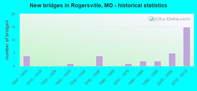
- New bridges - historical statistics
- 41900-1909
- 11930-1939
- 41950-1959
- 11970-1979
- 21980-1989
- 21990-1999
- 52000-2009
- 152010-2019


- Bridge Condition - Deck
- 23.1%Very good
- 69.2%Good
- 7.7%Satisfactory

- Bridge Condition - Superstructure
- 7.7%Very good
- 69.2%Good
- 15.4%Satisfactory
- 7.7%Fair

- Bridge Condition - Substructure
- 15.4%Excellent
- 30.8%Very good
- 30.8%Good
- 15.4%Satisfactory
- 7.7%Poor

- Bridge Condition - Channel
- 12.5%Very good
- 33.3%Good
- 29.2%Satisfactory
- 16.7%Fair
- 8.3%Poor

- Bridge Condition - Culverts
- 6.7%Very good
- 13.3%Good
- 46.7%Satisfactory
- 33.3%Fair
Find on map >> Show street view
Structure Number: 1698, Location: S 20 T 29 N R 20 W (Lat: 37.195681, Lng: -93.146597), Route carried "on" structure: County highway 138, Year Built: 1900, Status: Open, Structure Length: 0.64m (2.10ft), Average Daily Traffic: 231 (year 2020), Truck Traffic: 10%, Average Future Daily Traffic: 474 (year 2040), Features Intersected: BR OF JAMES RVR
Minimum Vertical Clearance: 30+ m (98+ ft), Kilometerpoint: 44.096, Lanes on structure: 2, Owner: County Highway Agency, Approaching Roadway Width: 6.1m (20.0ft), Material/Design: Concrete, Design/Construction: Culvert, Number Of Spans In Main Unit: 2, Length of Maximum Span: 3.4m (11.2ft), Curb-To-Curb Width: 8.2m (26.9ft), Out-to-Out Width: 8.8m (28.9ft)
Condition: Channel: Poor, Culverts: Fair, Operating Rating: 49.5 metric tons, Method Used To Determine Operating Rating: Allowable Stress (AS), Inventory Rating: 16.2 metric tons, Method Used To Determine Inventory Rating: Allowable Stress (AS), Structural Evaluation: Somewhat better than minimum adequacy, Deck Geometry: Somewhat better than minimum adequacy, Waterway Adequacy: Equal to present minimum criteria, Approach Roadway Alignment: Equal to present minimum criteria, Designated Inspection Frequency: Every 24 months, Inspection Date: March 2020, Deck Structure Type: Concrete Cast-file-Place, Wearing Surface/Protective System: Wearing Surface: Bituminous
Find on map >> Show street view
Structure Number: 172, Location: S 7 T 28 N R 19 W (Lat: 37.141600, Lng: -93.062233), Route carried "on" structure: State highway B, Year Built: 1957, Status: Open, Structure Length: 1.63m (5.35ft), Average Daily Traffic: 1,384 (year 2021), Truck Traffic: 5%, Average Future Daily Traffic: 2,214 (year 2041), Design Load: H 15, Features Intersected: WHITE OAK CR
Minimum Vertical Clearance: 30+ m (98+ ft), Kilometerpoint: 22.056, Lanes on structure: 2, Owner: State Highway Agency, Approaching Roadway Width: 7.0m (23.0ft), Skew: 4 degrees, Material/Design: Concrete continuous, Design/Construction: Culvert, Number Of Spans In Main Unit: 3, Length of Maximum Span: 3.7m (12.1ft), Curb-To-Curb Width: 7.9m (25.9ft), Out-to-Out Width: 8.5m (27.9ft)
Condition: Channel: Fair, Culverts: Satisfactory, Operating Rating: 66.6 metric tons, Method Used To Determine Operating Rating: Load Factor (LF), Inventory Rating: 40.5 metric tons, Method Used To Determine Inventory Rating: Load Factor (LF), Structural Evaluation: Equal to present minimum criteria, Deck Geometry: Meets minimum limits, Waterway Adequacy: Equal to present desirable criteria, Approach Roadway Alignment: Equal to present desirable criteria, Designated Inspection Frequency: Every 24 months, Inspection Date: November 2020
Find on map >> Show street view
Structure Number: 1739, Location: S 31 T 29 N R 20 W (Lat: 37.168383, Lng: -93.155114), Route carried "on" structure: County highway 150, Year Built: 1900, Status: Open, Structure Length: 0.76m (2.49ft), Average Daily Traffic: 528 (year 2020), Truck Traffic: 10%, Average Future Daily Traffic: 1,082 (year 2040), Features Intersected: BR OF TURNER CR
Minimum Vertical Clearance: 30+ m (98+ ft), Kilometerpoint: 40.877, Lanes on structure: 2, Owner: County Highway Agency, Approaching Roadway Width: 6.1m (20.0ft), Material/Design: Concrete, Design/Construction: Culvert, Number Of Spans In Main Unit: 2, Length of Maximum Span: 4.0m (13.1ft), Curb-To-Curb Width: 7.9m (25.9ft), Out-to-Out Width: 8.5m (27.9ft)
Condition: Channel: Good, Culverts: Fair, Operating Rating: 49.5 metric tons, Method Used To Determine Operating Rating: Allowable Stress (AS), Inventory Rating: 16.2 metric tons, Method Used To Determine Inventory Rating: Allowable Stress (AS), Structural Evaluation: Meets minimum limits, Deck Geometry: Somewhat better than minimum adequacy, Waterway Adequacy: Somewhat better than minimum adequacy, Approach Roadway Alignment: High priority of corrective action, Length Of Structure Improvement: 0.14m (0.46ft), Designated Inspection Frequency: Every 24 months, Inspection Date: March 2020, Bridge Improvement Cost: $85,000, Roadway Improvement Cost: $9,000, Total Project Cost: $128,000 ( Estimate for 2022), Deck Structure Type: Concrete Cast-file-Place, Wearing Surface/Protective System: Wearing Surface: Bituminous
Find on map >> Show street view
Structure Number: 18039, Location: S 7 T 28 N R 20 W (Lat: 37.134511, Lng: -93.168989), Route carried "on" structure: County highway 170, Year Built: 1989, Status: Open, Structure Length: 1.22m (4.00ft), Average Daily Traffic: 256 (year 2020), Truck Traffic: 10%, Average Future Daily Traffic: 525 (year 2040), Features Intersected: BR OF JAMES RVR
Minimum Vertical Clearance: 30+ m (98+ ft), Kilometerpoint: 39.590, Lanes on structure: 2, Owner: County Highway Agency, Approaching Roadway Width: 7.3m (24.0ft), Material/Design: Concrete, Design/Construction: Culvert, Number Of Spans In Main Unit: 3, Length of Maximum Span: 3.7m (12.1ft), Curb-To-Curb Width: 7.3m (24.0ft), Out-to-Out Width: 7.9m (25.9ft)
Condition: Channel: Good, Culverts: Good, Operating Rating: 49.5 metric tons, Method Used To Determine Operating Rating: Allowable Stress (AS), Inventory Rating: 32.4 metric tons, Method Used To Determine Inventory Rating: Allowable Stress (AS), Structural Evaluation: Better than present minimum criteria, Deck Geometry: Somewhat better than minimum adequacy, Waterway Adequacy: Equal to present desirable criteria, Approach Roadway Alignment: Equal to present desirable criteria, Designated Inspection Frequency: Every 24 months, Inspection Date: March 2020, Deck Structure Type: Concrete Cast-file-Place, Wearing Surface/Protective System: Wearing Surface: Bituminous
Find on map >> Show street view
Structure Number: 18042, Location: S 8 T 28 N R 20 W (Lat: 37.134117, Lng: -93.148506), Route carried "on" structure: County highway 170, Year Built: 1900, Status: Open, Structure Length: 1.74m (5.71ft), Average Daily Traffic: 402 (year 2020), Truck Traffic: 10%, Average Future Daily Traffic: 824 (year 2040), Features Intersected: BR OF JAMES RVR
Minimum Vertical Clearance: 30+ m (98+ ft), Kilometerpoint: 41.199, Lanes on structure: 2, Owner: County Highway Agency, Approaching Roadway Width: 6.7m (22.0ft), Material/Design: Concrete, Design/Construction: Culvert, Number Of Spans In Main Unit: 8, Length of Maximum Span: 2.1m (6.9ft), Curb-To-Curb Width: 7.4m (24.3ft), Out-to-Out Width: 8.0m (26.2ft)
Condition: Channel: Satisfactory, Culverts: Satisfactory, Operating Rating: 49.5 metric tons, Method Used To Determine Operating Rating: Allowable Stress (AS), Inventory Rating: 16.2 metric tons, Method Used To Determine Inventory Rating: Allowable Stress (AS), Structural Evaluation: Somewhat better than minimum adequacy, Deck Geometry: Meets minimum limits, Waterway Adequacy: Meets minimum limits, Approach Roadway Alignment: Equal to present desirable criteria, Designated Inspection Frequency: Every 24 months, Inspection Date: March 2020, Deck Structure Type: Concrete Cast-file-Place, Wearing Surface/Protective System: Wearing Surface: Bituminous
Find on map >> Show street view
Structure Number: 19619, Location: S 9 T 28 N R 20 W (Lat: 37.137661, Lng: -93.128144), Route carried "on" structure: County highway 227, Year Built: 1900, Status: Open, Structure Length: 0.64m (2.10ft), Average Daily Traffic: 73 (year 2020), Truck Traffic: 10%, Average Future Daily Traffic: 150 (year 2040), Features Intersected: BR OF JAMES RVR
Minimum Vertical Clearance: 30+ m (98+ ft), Kilometerpoint: 31.382, Lanes on structure: 2, Owner: County Highway Agency, Approaching Roadway Width: 6.1m (20.0ft), Material/Design: Concrete, Design/Construction: Culvert, Number Of Spans In Main Unit: 2, Length of Maximum Span: 3.4m (11.2ft), Curb-To-Curb Width: 6.1m (20.0ft), Out-to-Out Width: 6.7m (22.0ft)
Condition: Channel: Satisfactory, Culverts: Satisfactory, Operating Rating: 49.5 metric tons, Method Used To Determine Operating Rating: Allowable Stress (AS), Inventory Rating: 16.2 metric tons, Method Used To Determine Inventory Rating: Allowable Stress (AS), Structural Evaluation: Somewhat better than minimum adequacy, Deck Geometry: Somewhat better than minimum adequacy, Waterway Adequacy: Meets minimum limits, Approach Roadway Alignment: Equal to present desirable criteria, Designated Inspection Frequency: Every 24 months, Inspection Date: March 2020, Deck Structure Type: Concrete Cast-file-Place, Wearing Surface/Protective System: Wearing Surface: Bituminous
Find on map >> Show street view
Structure Number: 19957, Location: S 26 T 29 N R 20 W (Lat: 37.190222, Lng: -93.097794), Route carried "on" structure: County highway 241, Year Built: 1986, Status: Open, Structure Length: 0.94m (3.08ft), Average Daily Traffic: 73 (year 2020), Truck Traffic: 10%, Average Future Daily Traffic: 150 (year 2040), Features Intersected: SAWYER CR
Minimum Vertical Clearance: 30+ m (98+ ft), Kilometerpoint: 30.095, Lanes on structure: 2, Owner: County Highway Agency, Approaching Roadway Width: 7.3m (24.0ft), Material/Design: Concrete continuous, Design/Construction: Slab, Number Of Spans In Main Unit: 2, Length of Maximum Span: 7.3m (24.0ft), Curb-To-Curb Width: 7.2m (23.6ft), Out-to-Out Width: 7.8m (25.6ft)
Condition: Deck: Good, Superstructure: Good, Substructure: Poor, Channel: Good, Operating Rating: 49.5 metric tons, Method Used To Determine Operating Rating: Allowable Stress (AS), Inventory Rating: 16.2 metric tons, Method Used To Determine Inventory Rating: Allowable Stress (AS), Structural Evaluation: Meets minimum limits, Deck Geometry: Somewhat better than minimum adequacy, Waterway Adequacy: Equal to present desirable criteria, Approach Roadway Alignment: High priority of corrective action, Length Of Structure Improvement: 0.16m (0.52ft), Designated Inspection Frequency: Every 24 months, Inspection Date: March 2020, Bridge Improvement Cost: $115,000, Roadway Improvement Cost: $12,000, Total Project Cost: $173,000 ( Estimate for 2022), Deck Structure Type: Concrete Cast-file-Place, Wearing Surface/Protective System: Wearing Surface: Monolithic Concrete
Find on map >> Show street view
Structure Number: 21509, Location: S 27 T 28 N R 19 W (Lat: 37.091203, Lng: -93.003461), Route carried "on" structure: County highway 358, Year Built: 1996, Status: Open, Structure Length: 0.79m (2.59ft), Average Daily Traffic: 25 (year 2019), Truck Traffic: 10%, Average Future Daily Traffic: 41 (year 2039), Design Load: HS 20, Features Intersected: BR OF PEDELO CR, Facility Carried by Structure: LIBERTY RD
Minimum Vertical Clearance: 30+ m (98+ ft), Kilometerpoint: 2.253, Lanes on structure: 2, Owner: County Highway Agency, Approaching Roadway Width: 5.8m (19.0ft), Skew: 4 degrees, Material/Design: Concrete continuous, Design/Construction: Slab, Number Of Spans In Main Unit: 2, Length of Maximum Span: 3.9m (12.8ft), Curb-To-Curb Width: 8.9m (29.2ft), Out-to-Out Width: 9.4m (30.8ft)
Condition: Deck: Very good, Superstructure: Very good, Substructure: Good, Channel: Satisfactory, Operating Rating: 45.0 metric tons, Method Used To Determine Operating Rating: Allowable Stress (AS), Inventory Rating: 32.4 metric tons, Method Used To Determine Inventory Rating: Allowable Stress (AS), Structural Evaluation: Better than present minimum criteria, Deck Geometry: Better than present minimum criteria, Waterway Adequacy: Better than present minimum criteria, Approach Roadway Alignment: Equal to present desirable criteria, Designated Inspection Frequency: Every 24 months, Inspection Date: April 2021, Deck Structure Type: Concrete Cast-file-Place, Wearing Surface/Protective System: Wearing Surface: Monolithic Concrete
Find on map >> Show street view
Structure Number: 2622, Location: S 30 T 29 N R 20 W (Lat: 37.180114, Lng: -93.159372), Route carried "on" structure: State highway J, Year Built: 1974, Status: Posted for load, Structure Length: 7.83m (25.69ft), Average Daily Traffic: 1,665 (year 2021), Truck Traffic: 11%, Average Future Daily Traffic: 2,664 (year 2041), Design Load: H 15, Features Intersected: BNSF RR, TURNER CR
Minimum Vertical Clearance: 30+ m (98+ ft), Kilometerpoint: 0.079, Lanes on structure: 2, Owner: State Highway Agency, Approaching Roadway Width: 7.3m (24.0ft), Skew: 1 degrees, Material/Design: Steel continuous, Design/Construction: Stringer/Multi-beam, Number Of Spans In Main Unit: 5, Length of Maximum Span: 17.1m (56.1ft), Curb-To-Curb Width: 10.4m (34.1ft), Out-to-Out Width: 11.2m (36.7ft)
Condition: Deck: Satisfactory, Superstructure: Satisfactory, Substructure: Satisfactory, Channel: Good, Operating Rating: 28.8 metric tons, Method Used To Determine Operating Rating: Allowable Stress (AS), Inventory Rating: 16.2 metric tons, Method Used To Determine Inventory Rating: Allowable Stress (AS), Structural Evaluation: Meets minimum limits, Deck Geometry: Equal to present minimum criteria, Underclear: Equal to present minimum criteria, Waterway Adequacy: Equal to present desirable criteria, Approach Roadway Alignment: Equal to present desirable criteria, Designated Inspection Frequency: Every 24 months, Inspection Date: August 2020, Deck Structure Type: Concrete Cast-file-Place, Wearing Surface/Protective System: Wearing Surface: Bituminous
Find on map >> Show street view
Structure Number: 28202, Location: S 32 T 28 N R 19 W (Lat: 37.078564, Lng: -93.039353), Route carried "on" structure: County highway 603, Year Built: 1992, Status: Posted for load, Structure Length: 1.49m (4.89ft), Average Daily Traffic: 5 (year 2021), Truck Traffic: 10%, Average Future Daily Traffic: 10 (year 2041), Design Load: HS 20, Features Intersected: PEDELO CR, Facility Carried by Structure: LASLEY SPRINGS RD
Minimum Vertical Clearance: 30+ m (98+ ft), Kilometerpoint: 0.386, Lanes on structure: 1, Owner: County Highway Agency, Approaching Roadway Width: 4.0m (13.1ft), Material/Design: Steel, Design/Construction: Girder and Floorbeam System, Number Of Spans In Main Unit: 1, Length of Maximum Span: 14.9m (48.9ft), Curb-To-Curb Width: 3.6m (11.8ft), Out-to-Out Width: 3.8m (12.5ft)
Condition: Deck: Very good, Superstructure: Fair, Substructure: Satisfactory, Channel: Good, Operating Rating: 22.5 metric tons, Method Used To Determine Operating Rating: Load Factor (LF), Inventory Rating: 13.5 metric tons, Method Used To Determine Inventory Rating: Load Factor (LF), Structural Evaluation: Meets minimum limits, Deck Geometry: High priority of corrective action, Waterway Adequacy: Equal to present minimum criteria, Approach Roadway Alignment: Equal to present minimum criteria, Length Of Structure Improvement: 0.22m (0.72ft), Designated Inspection Frequency: Every 24 months, Critical Feature Inspection Frequency: Every 24 months, Inspection Date: January 2021, Critical Feature Inspection Date: January 2021, Bridge Improvement Cost: $160,000, Roadway Improvement Cost: $16,000, Total Project Cost: $240,000 ( Estimate for 2022), Deck Structure Type: Concrete Cast-file-Place, Wearing Surface/Protective System: Wearing Surface: Monolithic Concrete
Find on map >> Show street view
Structure Number: 30738, Location: S 7 T 28 N R 20 W (Lat: 37.134392, Lng: -93.161561), Route carried "on" structure: County highway 170, Year Built: 2003, Status: Open, Structure Length: 1.43m (4.69ft), Average Daily Traffic: 258 (year 2020), Truck Traffic: 10%, Average Future Daily Traffic: 529 (year 2040), Design Load: HS 20, Features Intersected: BR OF JAMES RVR
Minimum Vertical Clearance: 30+ m (98+ ft), Kilometerpoint: 40.073, Lanes on structure: 2, Owner: County Highway Agency, Approaching Roadway Width: 6.4m (21.0ft), Skew: 4 degrees, Material/Design: Concrete continuous, Design/Construction: Culvert, Number Of Spans In Main Unit: 3, Length of Maximum Span: 2.4m (7.9ft), Curb-To-Curb Width: 7.9m (25.9ft), Out-to-Out Width: 8.9m (29.2ft)
Condition: Channel: Good, Culverts: Satisfactory, Operating Rating: 54.0 metric tons, Method Used To Determine Operating Rating: Load Factor (LF), Inventory Rating: 32.4 metric tons, Method Used To Determine Inventory Rating: Load Factor (LF), Structural Evaluation: Equal to present minimum criteria, Deck Geometry: Somewhat better than minimum adequacy, Waterway Adequacy: Meets minimum limits, Approach Roadway Alignment: Equal to present desirable criteria, Designated Inspection Frequency: Every 24 months, Inspection Date: March 2020, Deck Structure Type: Concrete Cast-file-Place, Wearing Surface/Protective System: Wearing Surface: Bituminous
Find on map >> Show street view
Structure Number: 30739, Location: S 8 T 28 N R 20 W (Lat: 37.134272, Lng: -93.155317), Route carried "on" structure: County highway 170, Year Built: 2003, Status: Open, Structure Length: 1.43m (4.69ft), Average Daily Traffic: 402 (year 2020), Truck Traffic: 10%, Average Future Daily Traffic: 824 (year 2040), Design Load: HS 20, Features Intersected: BR OF JAMES RVR
Minimum Vertical Clearance: 30+ m (98+ ft), Kilometerpoint: 40.877, Lanes on structure: 2, Owner: County Highway Agency, Approaching Roadway Width: 6.4m (21.0ft), Skew: 4 degrees, Material/Design: Concrete continuous, Design/Construction: Culvert, Number Of Spans In Main Unit: 3, Length of Maximum Span: 2.4m (7.9ft), Curb-To-Curb Width: 7.9m (25.9ft), Out-to-Out Width: 8.9m (29.2ft)
Condition: Channel: Good, Culverts: Satisfactory, Operating Rating: 54.0 metric tons, Method Used To Determine Operating Rating: Load Factor (LF), Inventory Rating: 32.4 metric tons, Method Used To Determine Inventory Rating: Load Factor (LF), Structural Evaluation: Equal to present minimum criteria, Deck Geometry: Somewhat better than minimum adequacy, Waterway Adequacy: Meets minimum limits, Approach Roadway Alignment: Equal to present desirable criteria, Designated Inspection Frequency: Every 24 months, Inspection Date: March 2020, Deck Structure Type: Concrete Cast-file-Place, Wearing Surface/Protective System: Wearing Surface: Bituminous
Find on map >> Show street view
Structure Number: 30802, Location: S 22 T 29 N R 20 W (Lat: 37.192161, Lng: -93.104592), Route carried "on" structure: State highway AD, Year Built: 2005, Status: Open, Structure Length: 6.93m (22.74ft), Average Daily Traffic: 1,566 (year 2021), Truck Traffic: 6%, Average Future Daily Traffic: 2,506 (year 2041), Design Load: HS 20, Features Intersected: SAWYER CR
Minimum Vertical Clearance: 30+ m (98+ ft), Kilometerpoint: 1.727, Lanes on structure: 2, Owner: State Highway Agency, Approaching Roadway Width: 8.5m (27.9ft), Skew: 3 degrees, Material/Design: Prestressed concrete continuous, Design/Construction: Stringer/Multi-beam, Number Of Spans In Main Unit: 3, Length of Maximum Span: 23.4m (76.8ft), Curb-To-Curb Width: 12.2m (40.0ft), Out-to-Out Width: 13.0m (42.7ft)
Condition: Deck: Very good, Superstructure: Good, Substructure: Excellent, Channel: Good, Operating Rating: 76.5 metric tons, Method Used To Determine Operating Rating: Load Factor (LF), Inventory Rating: 45.0 metric tons, Method Used To Determine Inventory Rating: Load Factor (LF), Structural Evaluation: Better than present minimum criteria, Deck Geometry: Better than present minimum criteria, Waterway Adequacy: Superior to present desirable criteria, Approach Roadway Alignment: Equal to present desirable criteria, Designated Inspection Frequency: Every 24 months, Inspection Date: August 2020, Deck Structure Type: Concrete Cast-file-Place, Wearing Surface/Protective System: Wearing Surface: Monolithic Concrete, Deck Protection: Epoxy Coated Reinforcing
Find on map >> Show street view
Structure Number: 31893, Location: S 22 T 29 N R 20 W (Lat: 37.205883, Lng: -93.107986), Route carried "on" structure: County highway 134, Year Built: 2005, Status: Open, Structure Length: 1.68m (5.51ft), Average Daily Traffic: 87 (year 2020), Truck Traffic: 5%, Average Future Daily Traffic: 178 (year 2040), Design Load: HS 20, Features Intersected: BROAD CR
Minimum Vertical Clearance: 30+ m (98+ ft), Kilometerpoint: 0.000, Lanes on structure: 2, Owner: County Highway Agency, Approaching Roadway Width: 7.3m (24.0ft), Skew: 5 degrees, Material/Design: Concrete, Design/Construction: Culvert, Number Of Spans In Main Unit: 3, Length of Maximum Span: 5.3m (17.4ft)
Condition: Channel: Fair, Culverts: Satisfactory, Inventory Rating: 63.0 metric tons, Method Used To Determine Inventory Rating: Load Factor (LF), Structural Evaluation: Equal to present minimum criteria, Waterway Adequacy: Equal to present minimum criteria, Approach Roadway Alignment: Equal to present desirable criteria, Designated Inspection Frequency: Every 24 months, Inspection Date: March 2020, Deck Structure Type: Concrete Cast-file-Place, Wearing Surface/Protective System: Wearing Surface: Bituminous, Deck Protection: Epoxy Coated Reinforcing
Find on map >> Show street view
Structure Number: 32926, Location: S 29 T 28 N R 19 W (Lat: 37.089950, Lng: -93.034019), Route carried "on" structure: County highway , Year Built: 2008, Status: Open, Structure Length: 1.01m (3.31ft), Average Daily Traffic: 50 (year 2019), Truck Traffic: 10%, Average Future Daily Traffic: 83 (year 2039), Features Intersected: BR OF PADLOW CR, Facility Carried by Structure: DOGWOOD RIDGE RD
Minimum Vertical Clearance: 30+ m (98+ ft), Kilometerpoint: 0.000, Lanes on structure: 2, Owner: County Highway Agency, Approaching Roadway Width: 7.3m (24.0ft), Skew: 3 degrees, Material/Design: Concrete, Design/Construction: Slab, Number Of Spans In Main Unit: 2, Length of Maximum Span: 4.6m (15.1ft), Curb-To-Curb Width: 7.2m (23.6ft), Out-to-Out Width: 7.8m (25.6ft)
Condition: Deck: Good, Superstructure: Good, Substructure: Good, Channel: Satisfactory, Operating Rating: 59.4 metric tons, Method Used To Determine Operating Rating: Load Factor (LF), Inventory Rating: 35.1 metric tons, Method Used To Determine Inventory Rating: Load Factor (LF), Structural Evaluation: Better than present minimum criteria, Deck Geometry: Somewhat better than minimum adequacy, Waterway Adequacy: Equal to present minimum criteria, Approach Roadway Alignment: Equal to present minimum criteria, Designated Inspection Frequency: Every 24 months, Inspection Date: April 2021, Deck Structure Type: Concrete Cast-file-Place, Wearing Surface/Protective System: Wearing Surface: Monolithic Concrete
Find on map >> Show street view
Structure Number: 33029, Location: S 28 T 29 N R 20 W (Lat: 37.192275, Lng: -93.128314), Route carried "on" structure: State highway 125, Year Built: 2010, Status: Open, Structure Length: 11.98m (39.30ft), Average Daily Traffic: 2,485 (year 2021), Truck Traffic: 24%, Average Future Daily Traffic: 3,976 (year 2041), Features Intersected: JAMES RVR
Minimum Vertical Clearance: 30+ m (98+ ft), Kilometerpoint: 26.089, Lanes on structure: 2, Base Highway Network: Yes, Owner: State Highway Agency, Approaching Roadway Width: 8.5m (27.9ft), Material/Design: Prestressed concrete continuous, Design/Construction: Tee Beam, Number Of Spans In Main Unit: 4, Length of Maximum Span: 30.5m (100.1ft), Curb-To-Curb Width: 8.5m (27.9ft), Out-to-Out Width: 9.3m (30.5ft)
Condition: Deck: Good, Superstructure: Good, Substructure: Very good, Channel: Satisfactory, Operating Rating: 58.5 metric tons, Method Used To Determine Operating Rating: Load Factor (LF), Inventory Rating: 32.4 metric tons, Method Used To Determine Inventory Rating: Load Factor (LF), Structural Evaluation: Better than present minimum criteria, Deck Geometry: Meets minimum limits, Waterway Adequacy: Superior to present desirable criteria, Approach Roadway Alignment: Equal to present minimum criteria, Designated Inspection Frequency: Every 24 months, Inspection Date: August 2020, Deck Structure Type: Concrete Cast-file-Place, Wearing Surface/Protective System: Wearing Surface: Monolithic Concrete, Deck Protection: Epoxy Coated Reinforcing
Find on map >> Show street view
Structure Number: 3377, Location: S 31 T 29 N R 19 W (Lat: 37.162458, Lng: -93.058481), Route carried "on" structure: County highway 293, Year Built: 2010, Status: Open, Structure Length: 0.67m (2.20ft), Average Daily Traffic: 40 (year 2019), Truck Traffic: 10%, Average Future Daily Traffic: 66 (year 2039), Features Intersected: BR OF PANTHER CR, Facility Carried by Structure: BOBCAT RD
Minimum Vertical Clearance: 30+ m (98+ ft), Kilometerpoint: 0.000, Lanes on structure: 2, Owner: County Highway Agency, Approaching Roadway Width: 6.1m (20.0ft), Skew: 4 degrees, Material/Design: Concrete, Design/Construction: Slab, Number Of Spans In Main Unit: 1, Length of Maximum Span: 6.7m (22.0ft), Curb-To-Curb Width: 6.9m (22.6ft), Out-to-Out Width: 7.5m (24.6ft)
Condition: Deck: Good, Superstructure: Good, Substructure: Very good, Channel: Fair, Operating Rating: 78.3 metric tons, Method Used To Determine Operating Rating: Load Factor (LF), Inventory Rating: 46.8 metric tons, Method Used To Determine Inventory Rating: Load Factor (LF), Structural Evaluation: Better than present minimum criteria, Deck Geometry: Somewhat better than minimum adequacy, Waterway Adequacy: Equal to present minimum criteria, Approach Roadway Alignment: Equal to present minimum criteria, Designated Inspection Frequency: Every 24 months, Inspection Date: April 2021, Deck Structure Type: Concrete Cast-file-Place, Wearing Surface/Protective System: Wearing Surface: Monolithic Concrete
Find on map >> Show street view
Structure Number: 34473, Location: S 18 T 29 N R 19 W (Lat: 37.126339, Lng: -93.049833), Route carried "on" structure: City street , Year Built: 2012, Status: Open, Structure Length: 0.94m (3.08ft), Average Daily Traffic: 150 (year 2019), Truck Traffic: 10%, Average Future Daily Traffic: 248 (year 2039), Features Intersected: DRAIN DTCH, Facility Carried by Structure: SHORES PARKWAY
Minimum Vertical Clearance: 30+ m (98+ ft), Kilometerpoint: 0.000, Lanes on structure: 2, Owner: City or Municipal Highway Agency, Approaching Roadway Width: 10.7m (35.1ft), Material/Design: Concrete, Design/Construction: Culvert, Number Of Spans In Main Unit: 2, Length of Maximum Span: 4.6m (15.1ft), Curb-To-Curb Width: 10.7m (35.1ft), Out-to-Out Width: 11.0m (36.1ft)
Condition: Channel: Very good, Culverts: Good, Operating Rating: 52.2 metric tons, Method Used To Determine Operating Rating: Load Factor (LF), Inventory Rating: 31.5 metric tons, Method Used To Determine Inventory Rating: Load Factor (LF), Structural Evaluation: Better than present minimum criteria, Deck Geometry: Better than present minimum criteria, Waterway Adequacy: Equal to present desirable criteria, Approach Roadway Alignment: Equal to present desirable criteria, Designated Inspection Frequency: Every 24 months, Inspection Date: April 2021
Find on map >> Show street view
Structure Number: 34907, Location: S 3 T 28 N R 20 W (Lat: 37.161261, Lng: -93.118761), Route carried "on" structure: State highway 125, Year Built: 2015, Status: Open, Structure Length: 11.51m (37.76ft), Average Daily Traffic: 4,918 (year 2021), Truck Traffic: 13%, Average Future Daily Traffic: 7,869 (year 2041), Features Intersected: TURNER CR, BNSF RR, CULV
Minimum Vertical Clearance: 30+ m (98+ ft), Kilometerpoint: 29.871, Lanes on structure: 2, Lanes under structure: 2, Base Highway Network: Yes, Owner: State Highway Agency, Approaching Roadway Width: 9.1m (29.9ft), Skew: 4 degrees, Material/Design: Prestressed concrete, Design/Construction: Tee Beam, Number Of Spans In Main Unit: 4, Length of Maximum Span: 35.4m (116.1ft), Curb-To-Curb Width: 9.1m (29.9ft), Out-to-Out Width: 10.0m (32.8ft)
Condition: Deck: Good, Superstructure: Good, Substructure: Very good, Channel: Very good, Operating Rating: 77.4 metric tons, Method Used To Determine Operating Rating: Load Factor (LF), Inventory Rating: 36.0 metric tons, Method Used To Determine Inventory Rating: Load Factor (LF), Structural Evaluation: Better than present minimum criteria, Deck Geometry: Meets minimum limits, Underclear: Superior to present desirable criteria, Waterway Adequacy: Superior to present desirable criteria, Approach Roadway Alignment: Equal to present desirable criteria, Designated Inspection Frequency: Every 24 months, Inspection Date: August 2020, Deck Structure Type: Concrete Cast-file-Place, Wearing Surface/Protective System: Wearing Surface: Monolithic Concrete, Deck Protection: Epoxy Coated Reinforcing
Find on map >> Show street view
Structure Number: 35074, Location: S 19 T 28 N R 19 W (Lat: 37.110611, Lng: -93.057050), Route carried "on" structure: US 60, Year Built: 2015, Status: Open, Structure Length: 5.33m (17.49ft), Average Daily Traffic: 22,634 (year 2021), Truck Traffic: 23%, Average Future Daily Traffic: 41,873 (year 2041), Features Intersected: RT VV
Minimum Vertical Clearance: 30+ m (98+ ft), Kilometerpoint: 157.238, Lanes on structure: 4, Lanes under structure: 2, Base Highway Network: Yes, Owner: State Highway Agency, Approaching Roadway Width: 23.2m (76.1ft), Material/Design: Prestressed concrete continuous, Design/Construction: Tee Beam, Number Of Spans In Main Unit: 2, Length of Maximum Span: 28.7m (94.2ft), Curb-To-Curb Width: 23.2m (76.1ft), Out-to-Out Width: 24.6m (80.7ft)
Condition: Deck: Good, Superstructure: Good, Substructure: Very good, Operating Rating: 61.2 metric tons, Method Used To Determine Operating Rating: Load Factor (LF), Inventory Rating: 36.9 metric tons, Method Used To Determine Inventory Rating: Load Factor (LF), Structural Evaluation: Better than present minimum criteria, Deck Geometry: Superior to present desirable criteria, Underclear: Superior to present desirable criteria, Approach Roadway Alignment: Equal to present desirable criteria, Designated Inspection Frequency: Every 24 months, Inspection Date: November 2020, Deck Structure Type: Concrete Cast-file-Place, Wearing Surface/Protective System: Wearing Surface: Monolithic Concrete, Deck Protection: Epoxy Coated Reinforcing
Find on map >> Show street view
Structure Number: 35075, Location: S 19 T 28 N R 19 W (Lat: 37.113300, Lng: -93.074000), Route carried "on" structure: State highway B, Year Built: 2015, Status: Open, Structure Length: 5.79m (19.00ft), Average Daily Traffic: 1,822 (year 2021), Truck Traffic: 8%, Average Future Daily Traffic: 2,915 (year 2041), Features Intersected: US 60
Minimum Vertical Clearance: 30+ m (98+ ft), Kilometerpoint: 27.315, Lanes on structure: 2, Lanes under structure: 4, Owner: State Highway Agency, Approaching Roadway Width: 11.8m (38.7ft), Skew: 1 degrees, Material/Design: Prestressed concrete continuous, Design/Construction: Tee Beam, Number Of Spans In Main Unit: 2, Length of Maximum Span: 29.0m (95.1ft), Curb-To-Curb Width: 11.8m (38.7ft), Out-to-Out Width: 12.6m (41.3ft)
Condition: Deck: Good, Superstructure: Good, Substructure: Excellent, Operating Rating: 89.1 metric tons, Method Used To Determine Operating Rating: Load Factor (LF), Inventory Rating: 53.1 metric tons, Method Used To Determine Inventory Rating: Load Factor (LF), Structural Evaluation: Better than present minimum criteria, Deck Geometry: Equal to present minimum criteria, Underclear: Equal to present desirable criteria, Approach Roadway Alignment: Equal to present desirable criteria, Designated Inspection Frequency: Every 24 months, Inspection Date: August 2020, Deck Structure Type: Concrete Cast-file-Place, Wearing Surface/Protective System: Wearing Surface: Monolithic Concrete, Deck Protection: Epoxy Coated Reinforcing
Find on map >> Show street view
Structure Number: 35076, Location: S 23 T 28 N R 20 W (Lat: 37.117900, Lng: -93.087000), Route carried "on" structure: City street , Year Built: 2015, Status: Open, Structure Length: 6.37m (20.90ft), Average Daily Traffic: 436 (year 2021), Truck Traffic: 10%, Average Future Daily Traffic: 698 (year 2041), Features Intersected: US 60, Facility Carried by Structure: SPARK AVE S
Minimum Vertical Clearance: 30+ m (98+ ft), Kilometerpoint: 0.108, Lanes on structure: 2, Lanes under structure: 5, Owner: State Highway Agency, Approaching Roadway Width: 9.8m (32.2ft), Material/Design: Prestressed concrete continuous, Design/Construction: Tee Beam, Number Of Spans In Main Unit: 2, Length of Maximum Span: 32.0m (105.0ft), Curb-To-Curb Width: 9.8m (32.2ft), Out-to-Out Width: 10.6m (34.8ft)
Condition: Deck: Good, Superstructure: Good, Substructure: Good, Operating Rating: 81.9 metric tons, Method Used To Determine Operating Rating: Load Factor (LF), Inventory Rating: 49.5 metric tons, Method Used To Determine Inventory Rating: Load Factor (LF), Structural Evaluation: Better than present minimum criteria, Deck Geometry: Equal to present minimum criteria, Underclear: Superior to present desirable criteria, Approach Roadway Alignment: Equal to present minimum criteria, Designated Inspection Frequency: Every 24 months, Inspection Date: August 2020, Deck Structure Type: Concrete Cast-file-Place, Wearing Surface/Protective System: Wearing Surface: Monolithic Concrete, Deck Protection: Epoxy Coated Reinforcing
Find on map >> Show street view
Structure Number: 35121, Location: S 13 T 28 N R 20 W (Lat: 37.122786, Lng: -93.073506), Route carried "on" structure: State highway B, Year Built: 2016, Status: Open, Structure Length: 7.30m (23.95ft), Average Daily Traffic: 1,822 (year 2021), Truck Traffic: 8%, Average Future Daily Traffic: 2,915 (year 2041), Features Intersected: BNSF RR
Minimum Vertical Clearance: 30+ m (98+ ft), Kilometerpoint: 26.171, Lanes on structure: 2, Owner: State Highway Agency, Approaching Roadway Width: 9.1m (29.9ft), Skew: 1 degrees, Material/Design: Prestressed concrete, Design/Construction: Tee Beam, Number Of Spans In Main Unit: 3, Length of Maximum Span: 34.1m (111.9ft), Curb-To-Curb Width: 9.1m (29.9ft), Out-to-Out Width: 9.9m (32.5ft)
Condition: Deck: Good, Superstructure: Satisfactory, Substructure: Good, Operating Rating: 76.5 metric tons, Method Used To Determine Operating Rating: Load Factor (LF), Inventory Rating: 32.4 metric tons, Method Used To Determine Inventory Rating: Load Factor (LF), Structural Evaluation: Equal to present minimum criteria, Deck Geometry: Somewhat better than minimum adequacy, Underclear: Superior to present desirable criteria, Approach Roadway Alignment: Equal to present desirable criteria, Designated Inspection Frequency: Every 24 months, Inspection Date: August 2020, Deck Structure Type: Concrete Cast-file-Place, Wearing Surface/Protective System: Wearing Surface: Monolithic Concrete, Deck Protection: Epoxy Coated Reinforcing
Find on map >> Show street view
Structure Number: 35906, Location: S 31 T 29 N R 19 W (Lat: 37.162133, Lng: -93.058883), Route carried "on" structure: County highway 292, Year Built: 2018, Status: Open, Structure Length: 1.01m (3.31ft), Average Daily Traffic: 250 (year 2019), Truck Traffic: 10%, Average Future Daily Traffic: 413 (year 2039), Features Intersected: NORMAN BR, Facility Carried by Structure: LON RD
Minimum Vertical Clearance: 30+ m (98+ ft), Kilometerpoint: 3.058, Lanes on structure: 2, Owner: County Highway Agency, Approaching Roadway Width: 7.3m (24.0ft), Skew: 1 degrees, Material/Design: Concrete, Design/Construction: Culvert, Number Of Spans In Main Unit: 2, Length of Maximum Span: 4.7m (15.4ft), Curb-To-Curb Width: 7.3m (24.0ft), Out-to-Out Width: 8.0m (26.2ft)
Condition: Channel: Very good, Culverts: Very good, Operating Rating: 35.1 metric tons, Method Used To Determine Operating Rating: Load Factor (LF), Inventory Rating: 20.7 metric tons, Method Used To Determine Inventory Rating: Load Factor (LF), Structural Evaluation: Equal to present minimum criteria, Deck Geometry: Somewhat better than minimum adequacy, Waterway Adequacy: Superior to present desirable criteria, Approach Roadway Alignment: Equal to present desirable criteria, Designated Inspection Frequency: Every 24 months, Inspection Date: April 2021, Deck Structure Type: Concrete Cast-file-Place
Find on map >> Show street view
Structure Number: 6941, Location: S 3 T 28 N R 19 W (Lat: 37.161200, Lng: -93.007442), Route carried "on" structure: State highway PP, Year Built: 1958, Status: Open, Structure Length: 1.39m (4.56ft), Average Daily Traffic: 1,357 (year 2021), Truck Traffic: 11%, Average Future Daily Traffic: 2,171 (year 2041), Design Load: H 10, Features Intersected: PANTHER CR
Minimum Vertical Clearance: 30+ m (98+ ft), Kilometerpoint: 3.376, Lanes on structure: 2, Owner: State Highway Agency, Approaching Roadway Width: 6.7m (22.0ft), Skew: 3 degrees, Material/Design: Concrete continuous, Design/Construction: Culvert, Number Of Spans In Main Unit: 3, Length of Maximum Span: 3.7m (12.1ft), Curb-To-Curb Width: 9.1m (29.9ft), Out-to-Out Width: 9.7m (31.8ft)
Condition: Channel: Fair, Culverts: Fair, Operating Rating: 47.7 metric tons, Method Used To Determine Operating Rating: Load Factor (LF), Inventory Rating: 28.8 metric tons, Method Used To Determine Inventory Rating: Load Factor (LF), Structural Evaluation: Somewhat better than minimum adequacy, Deck Geometry: Somewhat better than minimum adequacy, Waterway Adequacy: Equal to present minimum criteria, Approach Roadway Alignment: Equal to present minimum criteria, Designated Inspection Frequency: Every 24 months, Inspection Date: November 2020
Find on map >> Show street view
Structure Number: 7516, Location: S 5 T 28 N R 19 W (Lat: 37.155289, Lng: -93.042631), Route carried "on" structure: State highway B, Year Built: 1951, Status: Open, Structure Length: 0.69m (2.26ft), Average Daily Traffic: 979 (year 2021), Truck Traffic: 8%, Average Future Daily Traffic: 1,566 (year 2041), Design Load: H 10, Features Intersected: NORMAN CR
Minimum Vertical Clearance: 30+ m (98+ ft), Kilometerpoint: 19.367, Lanes on structure: 2, Owner: State Highway Agency, Approaching Roadway Width: 7.0m (23.0ft), Material/Design: Concrete continuous, Design/Construction: Culvert, Number Of Spans In Main Unit: 2, Length of Maximum Span: 3.4m (11.2ft), Curb-To-Curb Width: 7.0m (23.0ft), Out-to-Out Width: 7.6m (24.9ft)
Condition: Channel: Satisfactory, Culverts: Satisfactory, Operating Rating: 43.2 metric tons, Method Used To Determine Operating Rating: Load Factor (LF), Inventory Rating: 26.1 metric tons, Method Used To Determine Inventory Rating: Load Factor (LF), Structural Evaluation: Equal to present minimum criteria, Deck Geometry: Meets minimum limits, Waterway Adequacy: Equal to present minimum criteria, Approach Roadway Alignment: Equal to present minimum criteria, Designated Inspection Frequency: Every 24 months, Inspection Date: November 2020
Find on map >> Show street view
Structure Number: 7518, Location: S 6 T 27 N R 19 W (Lat: 37.069333, Lng: -93.052667), Route carried "on" structure: State highway U, Year Built: 1951, Status: Open, Structure Length: 0.94m (3.08ft), Average Daily Traffic: 1,010 (year 2021), Truck Traffic: 5%, Average Future Daily Traffic: 1,970 (year 2041), Design Load: H 10, Features Intersected: PEDELO CR
Minimum Vertical Clearance: 30+ m (98+ ft), Kilometerpoint: 6.745, Lanes on structure: 2, Owner: State Highway Agency, Approaching Roadway Width: 8.2m (26.9ft), Material/Design: Concrete continuous, Design/Construction: Culvert, Number Of Spans In Main Unit: 3, Length of Maximum Span: 3.0m (9.8ft), Curb or Sidewalk Widths: Left: 0.2m (0.7ft), Right: 0.2m (0.7ft), Curb-To-Curb Width: 6.7m (22.0ft), Out-to-Out Width: 7.0m (23.0ft)
Condition: Channel: Poor, Culverts: Fair, Operating Rating: 53.1 metric tons, Method Used To Determine Operating Rating: Load Factor (LF), Inventory Rating: 32.4 metric tons, Method Used To Determine Inventory Rating: Load Factor (LF), Structural Evaluation: Somewhat better than minimum adequacy, Deck Geometry: High priority of corrective action, Waterway Adequacy: Meets minimum limits, Approach Roadway Alignment: Equal to present minimum criteria, Length Of Structure Improvement: 0.16m (0.52ft), Designated Inspection Frequency: Every 24 months, Inspection Date: January 2021, Bridge Improvement Cost: $170,000, Roadway Improvement Cost: $17,000, Total Project Cost: $255,000 ( Estimate for 2022), Deck Structure Type: Concrete Cast-file-Place, Wearing Surface/Protective System: Wearing Surface: Bituminous
Find on map >> Show street view
Structure Number: 9991, Location: S 31 T 29 N R 20 W (Lat: 37.174411, Lng: -93.159867), Route carried "on" structure: State highway J, Year Built: 1935, Year Reconstructed: 1951, Status: Open, Structure Length: 1.10m (3.61ft), Average Daily Traffic: 1,665 (year 2021), Truck Traffic: 11%, Average Future Daily Traffic: 2,664 (year 2041), Features Intersected: BR TURNER CR
Minimum Vertical Clearance: 30+ m (98+ ft), Kilometerpoint: 0.747, Lanes on structure: 2, Owner: State Highway Agency, Approaching Roadway Width: 7.3m (24.0ft), Skew: 3 degrees, Material/Design: Concrete continuous, Design/Construction: Culvert, Number Of Spans In Main Unit: 3, Length of Maximum Span: 3.0m (9.8ft), Curb-To-Curb Width: 6.1m (20.0ft), Out-to-Out Width: 7.0m (23.0ft)
Condition: Channel: Satisfactory, Culverts: Fair, Operating Rating: 24.3 metric tons, Method Used To Determine Operating Rating: Field evaluation and documented engineering judgment, Inventory Rating: 14.4 metric tons, Method Used To Determine Inventory Rating: Field evaluation and documented engineering judgment, Structural Evaluation: Meets minimum limits, Deck Geometry: High priority of replacement, Waterway Adequacy: Equal to present minimum criteria, Approach Roadway Alignment: Equal to present minimum criteria, Length Of Structure Improvement: 0.18m (0.59ft), Designated Inspection Frequency: Every 24 months, Inspection Date: January 2021, Bridge Improvement Cost: $250,000, Roadway Improvement Cost: $25,000, Total Project Cost: $375,000 ( Estimate for 2022)
Find on map >> Show street view
Structure Number: 35074, Location: S 19 T 28 N R 19 W (Lat: 37.110611, Lng: -93.057050), Route carried "under" structure: State highway VV, Year Built: 2015, Structure Length: 0. m, Average Daily Traffic: 848 (year 2021), Truck Traffic: 3%, Features Intersected: RT VV, Facility Carried by Structure: US 60 E
Minimum Vertical Clearance: 5.30m (17.39ft), Kilometerpoint: 0.072, Lanes on structure: 4, Lanes under structure: 1, Material/Design: Prestressed concrete continuous, Design/Construction: Tee Beam, Length of Maximum Span: 28.7m (94.2ft)
Find on map >> Show street view
Structure Number: 35074, Location: S 19 T 28 N R 19 W (Lat: 37.110611, Lng: -93.057050), Route carried "under" structure: State highway VV, Year Built: 2015, Structure Length: 0. m, Average Daily Traffic: 1,161 (year 2021), Truck Traffic: 11%, Features Intersected: RT VV, Facility Carried by Structure: US 60 E
Minimum Vertical Clearance: 5.30m (17.39ft), Kilometerpoint: 5.095, Lanes on structure: 4, Lanes under structure: 1, Material/Design: Prestressed concrete continuous, Design/Construction: Tee Beam, Length of Maximum Span: 28.7m (94.2ft)
Find on map >> Show street view
Structure Number: 35075, Location: S 19 T 28 N R 19 W (Lat: 37.113300, Lng: -93.074000), Route carried "under" structure: US 60, Year Built: 2015, Structure Length: 0. m, Average Daily Traffic: 11,588 (year 2021), Truck Traffic: 22%, Features Intersected: US 60, Facility Carried by Structure: RT B S
Minimum Vertical Clearance: 5.13m (16.83ft), Kilometerpoint: 392.438, Lanes on structure: 2, Lanes under structure: 2, Material/Design: Prestressed concrete continuous, Design/Construction: Tee Beam, Length of Maximum Span: 29.0m (95.1ft)
Find on map >> Show street view
Structure Number: 35075, Location: S 19 T 28 N R 19 W (Lat: 37.113300, Lng: -93.074000), Route carried "under" structure: US 60, Year Built: 2015, Structure Length: 0. m, Average Daily Traffic: 11,046 (year 2021), Truck Traffic: 23%, Features Intersected: US 60, Facility Carried by Structure: RT B S
Minimum Vertical Clearance: 5.18m (16.99ft), Kilometerpoint: 155.738, Lanes on structure: 2, Lanes under structure: 2, Material/Design: Prestressed concrete continuous, Design/Construction: Tee Beam, Length of Maximum Span: 29.0m (95.1ft)
Find on map >> Show street view
Structure Number: 35076, Location: S 23 T 28 N R 20 W (Lat: 37.117900, Lng: -93.087000), Route carried "under" structure: US 60, Year Built: 2015, Structure Length: 0. m, Average Daily Traffic: 14,990 (year 2021), Truck Traffic: 16%, Features Intersected: US 60, Facility Carried by Structure: SPARK AVE S
Minimum Vertical Clearance: 5.05m (16.57ft), Kilometerpoint: 393.796, Lanes on structure: 2, Lanes under structure: 3, Material/Design: Prestressed concrete continuous, Design/Construction: Tee Beam, Length of Maximum Span: 32.0m (105.0ft)
Find on map >> Show street view
Structure Number: 35076, Location: S 23 T 28 N R 20 W (Lat: 37.117900, Lng: -93.087000), Route carried "under" structure: US 60, Year Built: 2015, Structure Length: 0. m, Average Daily Traffic: 14,600 (year 2021), Truck Traffic: 17%, Features Intersected: US 60, Facility Carried by Structure: SPARK AVE S
Minimum Vertical Clearance: 5.56m (18.24ft), Kilometerpoint: 154.385, Lanes on structure: 2, Lanes under structure: 2, Material/Design: Prestressed concrete continuous, Design/Construction: Tee Beam, Length of Maximum Span: 32.0m (105.0ft)