Bridge Statistics for Rolling Prairie, Indiana (IN)
Condition, Traffic, Stress, Structural Evaluation, Project Costs
- National Bridge Inventory (NBI) Statistics
- 12Number of bridges
- 121ft / 36.5mTotal length
- 118,466Total average daily traffic
- 19,387Total average daily truck traffic
- National Bridge Inventory (NBI) Registered Bridges for Rolling Prairie
- No street view available for this location
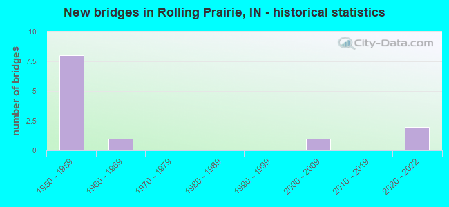
- New bridges - historical statistics
- 81950-1959
- 11960-1969
- 12000-2009
- 22020-2022

- Reconstructed bridges - Historical Statistics
- 41980-1989
- 11990-1999


- Bridge Condition - Deck
- 33.3%Very good
- 16.7%Good
- 33.3%Satisfactory
- 16.7%Fair

- Bridge Condition - Superstructure
- 16.7%Excellent
- 33.3%Good
- 50.0%Satisfactory

- Bridge Condition - Substructure
- 16.7%Very good
- 33.3%Good
- 33.3%Satisfactory
- 16.7%Fair
Find on map >> Show street view
Structure Number: 5305, Location: 03.60 E SR 39 (Lat: 41.677631, Lng: -86.668411), Route carried "on" structure: US 20, Year Built: 1956, Year Reconstructed: 1989, Status: Open, Structure Length: 6.28m (20.60ft), Average Daily Traffic: 13,623 (year 2004), Truck Traffic: 10%, Average Future Daily Traffic: 18,868 (year 2029), Design Load: HS 20, Features Intersected: I-90 EB/WB
Minimum Vertical Clearance: 30+ m (98+ ft), Kilometerpoint: 23.110, Lanes on structure: 4, Lanes under structure: 4, Base Highway Network: Yes (, Subroute: 1), Owner: State Toll Authority, Maintenance Responsibility: State Highway Agency, Approaching Roadway Width: 18.3m (60.0ft), Skew: 1 degrees, Material/Design: Steel continuous, Design/Construction: Stringer/Multi-beam, Number Of Spans In Main Unit: 5, Length of Maximum Span: 13.7m (44.9ft), Curb-To-Curb Width: 26.0m (85.3ft), Out-to-Out Width: 26.9m (88.3ft)
Condition: Deck: Very good, Superstructure: Excellent, Substructure: Very good, Operating Rating: 55.1 metric tons, Method Used To Determine Operating Rating: Load and Resistance Factor Rating (LRFR) rating reported by rating factor(RF) method using HL-93 loadings, Inventory Rating: 42.4 metric tons, Method Used To Determine Inventory Rating: Load and Resistance Factor Rating (LRFR) rating reported by rating factor(RF) method using HL-93 loadings, Structural Evaluation: Equal to present desirable criteria, Deck Geometry: Superior to present desirable criteria, Underclear: Meets minimum limits, Approach Roadway Alignment: Equal to present desirable criteria, Designated Inspection Frequency: Every 24 months, Inspection Date: July 2021, Deck Structure Type: Concrete Cast-file-Place, Wearing Surface/Protective System: Wearing Surface: Monolithic Concrete, Deck Protection: Epoxy Coated Reinforcing
Find on map >> Show street view
Structure Number: 531, Location: 01.44 W SR 2 (Lat: 41.670619, Lng: -86.616097), Route carried "on" structure: US 20, Year Built: 2004, Status: Open, Structure Length: 3.35m (10.99ft), Average Daily Traffic: 13,623 (year 2004), Truck Traffic: 10%, Average Future Daily Traffic: 18,868 (year 2030), Design Load: HS 20+Mod, Features Intersected: N&S RR
Minimum Vertical Clearance: 30+ m (98+ ft), Kilometerpoint: 27.455, Lanes on structure: 4, Base Highway Network: Yes (, Subroute: 1), Owner: State Highway Agency, Approaching Roadway Width: 21.9m (71.9ft), Skew: 3 degrees, Material/Design: Prestressed concrete, Design/Construction: Tee Beam, Number Of Spans In Main Unit: 1, Length of Maximum Span: 32.8m (107.6ft), Curb-To-Curb Width: 22.0m (72.2ft), Out-to-Out Width: 22.9m (75.1ft)
Condition: Deck: Very good, Superstructure: Good, Substructure: Fair, Operating Rating: 84.2 metric tons, Method Used To Determine Operating Rating: Load and Resistance Factor Rating (LRFR) rating reported by rating factor(RF) method using HL-93 loadings, Inventory Rating: 62.9 metric tons, Method Used To Determine Inventory Rating: Load and Resistance Factor Rating (LRFR) rating reported by rating factor(RF) method using HL-93 loadings, Structural Evaluation: Somewhat better than minimum adequacy, Deck Geometry: Superior to present desirable criteria, Underclear: Better than present minimum criteria, Approach Roadway Alignment: Equal to present desirable criteria, Designated Inspection Frequency: Every 24 months, Inspection Date: September 2021, Deck Structure Type: Concrete Cast-file-Place, Wearing Surface/Protective System: Wearing Surface: Monolithic Concrete, Deck Protection: Epoxy Coated Reinforcing
Find on map >> Show street view
Structure Number: 4742, Location: 07.41 E SR 39 (Lat: 41.710311, Lng: -86.617539), Route carried "on" structure: County highway , Year Built: 1956, Year Reconstructed: 1987, Status: Open, Structure Length: 9.69m (31.79ft), Average Daily Traffic: 608 (year 2014), Truck Traffic: 10%, Average Future Daily Traffic: 998 (year 2031), Design Load: HS 20, Features Intersected: I-90 EB/WB, Facility Carried by Structure: CR 425 E/TEETER RD
Minimum Vertical Clearance: 30+ m (98+ ft), Kilometerpoint: 0.000, Lanes on structure: 2, Lanes under structure: 4, Owner: State Toll Authority, Approaching Roadway Width: 11.0m (36.1ft), Skew: 4 degrees, Material/Design: Steel, Design/Construction: Stringer/Multi-beam, Number Of Spans In Main Unit: 5, Length of Maximum Span: 21.9m (71.9ft), Curb or Sidewalk Widths: Left: 0.2m (0.7ft), Right: 0.2m (0.7ft), Curb-To-Curb Width: 7.9m (25.9ft), Out-to-Out Width: 9.1m (29.9ft)
Condition: Deck: Satisfactory, Superstructure: Satisfactory, Substructure: Satisfactory, Operating Rating: 47.3 metric tons, Method Used To Determine Operating Rating: Load and Resistance Factor Rating (LRFR) rating reported by rating factor(RF) method using HL-93 loadings, Inventory Rating: 36.6 metric tons, Method Used To Determine Inventory Rating: Load and Resistance Factor Rating (LRFR) rating reported by rating factor(RF) method using HL-93 loadings, Structural Evaluation: Equal to present minimum criteria, Deck Geometry: Somewhat better than minimum adequacy, Underclear: High priority of corrective action, Approach Roadway Alignment: Equal to present minimum criteria, Designated Inspection Frequency: Every 24 months, Other Special Inspection Frequency: Every 24 months, Inspection Date: July 2021, Other Special Inspection Date: July 2021, Deck Structure Type: Concrete Cast-file-Place, Wearing Surface/Protective System: Wearing Surface: Latex Concrete
Find on map >> Show street view
Structure Number: 4743, Location: 08.01 E SR 39 (Lat: 41.716819, Lng: -86.609772), Route carried "on" structure: Interstate 90, Year Built: 1956, Year Reconstructed: 1987, Status: Open, Structure Length: 6.74m (22.11ft), Average Daily Traffic: 12,966 (year 2011), Truck Traffic: 24%, Average Future Daily Traffic: 26,252 (year 2031), Design Load: HS 20, Features Intersected: CSS & SB RR
Minimum Vertical Clearance: 30+ m (98+ ft), Kilometerpoint: 91.588, Lanes on structure: 2, Base Highway Network: Yes (, Subroute: 1), Toll: On toll road, Owner: State Toll Authority, Approaching Roadway Width: 12.8m (42.0ft), Skew: 3 degrees, Material/Design: Steel, Design/Construction: Stringer/Multi-beam, Number Of Spans In Main Unit: 3, Length of Maximum Span: 23.2m (76.1ft), Curb-To-Curb Width: 10.1m (33.1ft), Out-to-Out Width: 10.7m (35.1ft)
Condition: Deck: Satisfactory, Superstructure: Satisfactory, Substructure: Good, Operating Rating: 81.4 metric tons, Method Used To Determine Operating Rating: Load Factor (LF), Inventory Rating: 48.8 metric tons, Method Used To Determine Inventory Rating: Load Factor (LF), Structural Evaluation: Equal to present minimum criteria, Deck Geometry: Meets minimum limits, Underclear: Somewhat better than minimum adequacy, Approach Roadway Alignment: Equal to present desirable criteria, Designated Inspection Frequency: Every 24 months, Other Special Inspection Frequency: Every 24 months, Inspection Date: July 2021, Other Special Inspection Date: July 2021, Deck Structure Type: Concrete Cast-file-Place, Wearing Surface/Protective System: Wearing Surface: Latex Concrete
Find on map >> Show street view
Structure Number: 4744, Location: 08.01 E SR 39 (Lat: 41.716819, Lng: -86.610147), Route carried "on" structure: Interstate 90, Year Built: 1956, Year Reconstructed: 1987, Status: Open, Structure Length: 6.74m (22.11ft), Average Daily Traffic: 12,966 (year 2011), Truck Traffic: 24%, Average Future Daily Traffic: 26,252 (year 2031), Design Load: HS 20, Features Intersected: CSS & SB RR
Minimum Vertical Clearance: 30+ m (98+ ft), Kilometerpoint: 91.588, Lanes on structure: 2, Base Highway Network: Yes (, Subroute: 1), Toll: On toll road, Owner: State Toll Authority, Approaching Roadway Width: 12.8m (42.0ft), Skew: 3 degrees, Material/Design: Steel, Design/Construction: Stringer/Multi-beam, Number Of Spans In Main Unit: 3, Length of Maximum Span: 23.2m (76.1ft), Curb-To-Curb Width: 10.1m (33.1ft), Out-to-Out Width: 10.7m (35.1ft)
Condition: Deck: Fair, Superstructure: Satisfactory, Substructure: Good, Operating Rating: 81.4 metric tons, Method Used To Determine Operating Rating: Load Factor (LF), Inventory Rating: 48.8 metric tons, Method Used To Determine Inventory Rating: Load Factor (LF), Structural Evaluation: Equal to present minimum criteria, Deck Geometry: Meets minimum limits, Underclear: Somewhat better than minimum adequacy, Approach Roadway Alignment: Equal to present desirable criteria, Designated Inspection Frequency: Every 24 months, Other Special Inspection Frequency: Every 24 months, Inspection Date: July 2021, Other Special Inspection Date: July 2021, Deck Structure Type: Concrete Cast-file-Place, Wearing Surface/Protective System: Wearing Surface: Latex Concrete
Find on map >> Show street view
Structure Number: 4600123, Location: 00.80 N CR 700 N (Lat: 41.717319, Lng: -86.668769), Route carried "on" structure: County highway , Year Built: 1960, Year Reconstructed: 2002, Status: Open, Structure Length: 3.75m (12.30ft), Average Daily Traffic: 1,500 (year 2020), Truck Traffic: 5%, Average Future Daily Traffic: 2,500 (year 2040), Design Load: HS 20, Features Intersected: NICTD RR, Facility Carried by Structure: FAIL ROAD
Minimum Vertical Clearance: 30+ m (98+ ft), Kilometerpoint: 0.000, Lanes on structure: 2, Owner: County Highway Agency, Approaching Roadway Width: 7.3m (24.0ft), Skew: 3 degrees, Material/Design: Steel continuous, Design/Construction: Stringer/Multi-beam, Number Of Spans In Main Unit: 3, Length of Maximum Span: 13.7m (44.9ft), Curb-To-Curb Width: 8.4m (27.6ft), Out-to-Out Width: 9.3m (30.5ft)
Condition: Deck: Good, Superstructure: Good, Substructure: Satisfactory, Operating Rating: 32.7 metric tons, Method Used To Determine Operating Rating: Field evaluation and documented engineering judgment, Inventory Rating: 32.7 metric tons, Method Used To Determine Inventory Rating: Field evaluation and documented engineering judgment, Structural Evaluation: Equal to present minimum criteria, Deck Geometry: Meets minimum limits, Underclear: Somewhat better than minimum adequacy, Approach Roadway Alignment: Equal to present minimum criteria, Designated Inspection Frequency: Every 24 months, Inspection Date: September 2020, Deck Structure Type: Concrete Cast-file-Place, Wearing Surface/Protective System: Wearing Surface: Monolithic Concrete, Deck Protection: Epoxy Coated Reinforcing
Find on map >> Show street view
Structure Number: 5305, Location: 03.60 E SR-39 (Lat: 41.677631, Lng: -86.668419), Route carried "under" structure: Interstate 90, Year Built: 1956, Structure Length: 0. m, Average Daily Traffic: 13,360 (year 2004), Truck Traffic: 10%, Features Intersected: I-90 WBL, Facility Carried by Structure: US 20
Minimum Vertical Clearance: 5.05m (16.57ft), Kilometerpoint: 84.989, Lanes on structure: 4, Lanes under structure: 4, Material/Design: Steel continuous, Design/Construction: Stringer/Multi-beam, Length of Maximum Span: 13.7m (44.9ft)
Find on map >> Show street view
Structure Number: 5305, Location: 03.60 E SR-39 (Lat: 41.677631, Lng: -86.668419), Route carried "under" structure: Interstate 90, Year Built: 1956, Structure Length: 0. m, Average Daily Traffic: 13,360 (year 2004), Truck Traffic: 10%, Features Intersected: I-90 EBL, Facility Carried by Structure: US 20
Minimum Vertical Clearance: 5.05m (16.57ft), Kilometerpoint: 84.989, Lanes on structure: 4, Lanes under structure: 4, Material/Design: Steel continuous, Design/Construction: Stringer/Multi-beam, Length of Maximum Span: 13.7m (44.9ft)
Find on map >> Show street view
Structure Number: 5315, Location: 07.82 E SR 39 (Lat: 41.672889, Lng: -86.588989), Route carried "under" structure: US 20, Year Built: 2020, Structure Length: 0. m, Average Daily Traffic: 4,650 (year 2016), Truck Traffic: 12%, Features Intersected: SR 2 WBL to US 20 WBL
Minimum Vertical Clearance: 5.03m (16.50ft), Kilometerpoint: 84.989, Lanes on structure: 2, Lanes under structure: 4, Material/Design: Prestressed concrete continuous, Design/Construction: Stringer/Multi-beam, Length of Maximum Span: 22.0m (72.2ft)
Find on map >> Show street view
Structure Number: 5315, Location: 07.82 E SR 39 (Lat: 41.672889, Lng: -86.588989), Route carried "under" structure: US 20, Year Built: 2020, Structure Length: 0. m, Average Daily Traffic: 4,650 (year 2016), Truck Traffic: 12%, Features Intersected: US 20 EBL to SR 2 EBL
Minimum Vertical Clearance: 5.05m (16.57ft), Kilometerpoint: 84.989, Lanes on structure: 2, Lanes under structure: 4, Material/Design: Prestressed concrete continuous, Design/Construction: Stringer/Multi-beam, Length of Maximum Span: 22.0m (72.2ft)
Find on map >> Show street view
Structure Number: 4742, Location: 07.41 E SR 39 (Lat: 41.710311, Lng: -86.617539), Route carried "under" structure: Interstate 90, Year Built: 1956, Structure Length: 0. m, Average Daily Traffic: 13,580 (year 2011), Truck Traffic: 24%, Features Intersected: I-90 EB, Facility Carried by Structure: CR 425E/TEETER RD
Minimum Vertical Clearance: 4.78m (15.68ft), Kilometerpoint: 90.622, Lanes on structure: 2, Lanes under structure: 2, Toll: On toll road, Material/Design: Steel, Design/Construction: Stringer/Multi-beam, Length of Maximum Span: 21.9m (71.9ft)
Find on map >> Show street view
Structure Number: 4742, Location: 07.41 E SR 39 (Lat: 41.710311, Lng: -86.617539), Route carried "under" structure: Interstate 90, Year Built: 1956, Structure Length: 0. m, Average Daily Traffic: 13,580 (year 2011), Truck Traffic: 24%, Features Intersected: I-90 WB, Facility Carried by Structure: CR 425E/TEETER RD
Minimum Vertical Clearance: 4.78m (15.68ft), Kilometerpoint: 90.622, Lanes on structure: 2, Lanes under structure: 2, Toll: On toll road, Material/Design: Steel, Design/Construction: Stringer/Multi-beam, Length of Maximum Span: 21.9m (71.9ft)