Bridge Statistics for Roosevelt, New Jersey (NJ)
Condition, Traffic, Stress, Structural Evaluation, Project Costs
- National Bridge Inventory (NBI) Statistics
- 14Number of bridges
- 95ft / 28.6mTotal length
- $5,009,000Total costs
- 215,019Total average daily traffic
- 28,732Total average daily truck traffic
- National Bridge Inventory (NBI) Registered Bridges for Roosevelt
- No street view available for this location
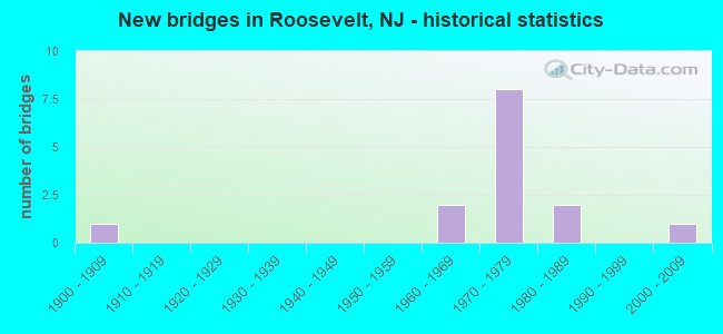
- New bridges - historical statistics
- 11900-1909
- 21960-1969
- 81970-1979
- 21980-1989
- 12000-2009


- Bridge Condition - Deck
- 12.5%Good
- 50.0%Satisfactory
- 37.5%Fair

- Bridge Condition - Superstructure
- 12.5%Very good
- 50.0%Good
- 25.0%Satisfactory
- 12.5%Serious

- Bridge Condition - Substructure
- 75.0%Good
- 12.5%Satisfactory
- 12.5%Fair

- Bridge Condition - Channel
- 50.0%Good
- 25.0%Satisfactory
- 25.0%Fair
Find on map >> Show street view
Structure Number: 130MS15, Location: 0.7 MILES NORTH CR 537 (Lat: 40.159781, Lng: -74.445939), Route carried "on" structure: Other road , Year Built: 1980, Status: Open, Structure Length: 0.98m (3.22ft), Average Daily Traffic: 142 (year 2021), Truck Traffic: 3%, Average Future Daily Traffic: 170 (year 2041), Design Load: HS 20, Features Intersected: IVANHOE BROOK, Facility Carried by Structure: OLDE NOAH HUNT RD
Minimum Vertical Clearance: 30+ m (98+ ft), Kilometerpoint: 0.000, Lanes on structure: 2, Owner: County Highway Agency, Approaching Roadway Width: 9.1m (29.9ft), Skew: 1 degrees, Material/Design: Prestressed concrete, Design/Construction: Box Beam or Girders - Multiple, Number Of Spans In Main Unit: 1, Length of Maximum Span: 9.1m (29.9ft), Curb or Sidewalk Widths: Left: 0.5m (1.6ft), Right: 0.5m (1.6ft), Curb-To-Curb Width: 9.2m (30.2ft), Out-to-Out Width: 10.2m (33.5ft)
Condition: Deck: Satisfactory, Superstructure: Satisfactory, Substructure: Satisfactory, Channel: Satisfactory, Operating Rating: 59.0 metric tons, Method Used To Determine Operating Rating: Load Factor (LF), Inventory Rating: 36.3 metric tons, Method Used To Determine Inventory Rating: Load Factor (LF), Structural Evaluation: Equal to present minimum criteria, Deck Geometry: Equal to present minimum criteria, Waterway Adequacy: Equal to present desirable criteria, Approach Roadway Alignment: Equal to present minimum criteria, Designated Inspection Frequency: Every 24 months, Inspection Date: March 2021, Deck Structure Type: Concrete Precast Panels, Wearing Surface/Protective System: Wearing Surface: Bituminous
Find on map >> Show street view
Structure Number: 130MS26, Location: 0.21 MI EAST OF CO RD 571 (Lat: 40.236511, Lng: -74.472800), Route carried "on" structure: County highway 1, Year Built: 1988, Status: Open, Structure Length: 1.13m (3.71ft), Average Daily Traffic: 3,110 (year 2021), Truck Traffic: 5%, Average Future Daily Traffic: 3,732 (year 2041), Design Load: HS 20+Mod, Features Intersected: ROCKY BROOK
Minimum Vertical Clearance: 30+ m (98+ ft), Kilometerpoint: 0.338, Lanes on structure: 2, Owner: County Highway Agency, Approaching Roadway Width: 12.2m (40.0ft), Material/Design: Prestressed concrete, Design/Construction: Box Beam or Girders - Multiple, Number Of Spans In Main Unit: 1, Length of Maximum Span: 10.7m (35.1ft), Curb or Sidewalk Widths: Left: 0.3m (1.0ft), Right: 0.3m (1.0ft), Curb-To-Curb Width: 12.2m (40.0ft), Out-to-Out Width: 13.4m (44.0ft)
Condition: Deck: Fair, Superstructure: Good, Substructure: Good, Channel: Good, Inventory Rating: 51.7 metric tons, Method Used To Determine Inventory Rating: Load Factor (LF), Structural Evaluation: Better than present minimum criteria, Deck Geometry: Equal to present minimum criteria, Waterway Adequacy: Superior to present desirable criteria, Approach Roadway Alignment: Equal to present desirable criteria, Designated Inspection Frequency: Every 24 months, Underwater Inspection Frequency: Every 24 months, Inspection Date: March 2021, Underwater Inspection Date: April 2021, Deck Structure Type: Concrete Cast-file-Place, Wearing Surface/Protective System: Wearing Surface: Monolithic Concrete, Deck Protection: Epoxy Coated Reinforcing
Find on map >> Show street view
Structure Number: 130MS48, Location: 3 MI S OF INTSECT W RT 33 (Lat: 40.227261, Lng: -74.439361), Route carried "on" structure: County highway 1, Year Built: 1900, Status: Posted for load, Structure Length: 1.13m (3.71ft), Average Daily Traffic: 2,450 (year 2021), Truck Traffic: 5%, Average Future Daily Traffic: 2,930 (year 2041), Features Intersected: TRIBUTARY TO ROCKY BROOK, Facility Carried by Structure: PERRINEVILLE ROAD
Minimum Vertical Clearance: 30+ m (98+ ft), Kilometerpoint: 3.862, Lanes on structure: 2, Owner: County Highway Agency, Approaching Roadway Width: 7.3m (24.0ft), Material/Design: Steel, Design/Construction: Stringer/Multi-beam, Number Of Spans In Main Unit: 1, Length of Maximum Span: 11.0m (36.1ft), Curb-To-Curb Width: 7.2m (23.6ft), Out-to-Out Width: 7.4m (24.3ft)
Condition: Deck: Fair, Superstructure: Serious, Substructure: Fair, Channel: Fair, Operating Rating: 19.1 metric tons, Method Used To Determine Operating Rating: Load Factor (LF), Inventory Rating: 10.9 metric tons, Method Used To Determine Inventory Rating: Load Factor (LF), Structural Evaluation: High priority of replacement, Deck Geometry: High priority of replacement, Waterway Adequacy: Superior to present desirable criteria, Approach Roadway Alignment: Meets minimum limits, Bridge Posting: Required (Relationship of Operating Rating to Maximum Legal Load: 30.0 - 39.9% below), Length Of Structure Improvement: 1.80m (5.91ft), Designated Inspection Frequency: Every 24 months, Other Special Inspection Frequency: Every 12 months, Inspection Date: March 2021, Other Special Inspection Date: March 2021, Bridge Improvement Cost: $1,041,000, Roadway Improvement Cost: $156,000, Total Project Cost: $1,785,000 ( Estimate for 2021), Deck Structure Type: Wood or Timber, Wearing Surface/Protective System: Wearing Surface: Bituminous
Find on map >> Show street view
Structure Number: 130MS49, Location: 2.8 MI SOUTH RT 33 (Lat: 40.229419, Lng: -74.441850), Route carried "on" structure: County highway 1, Year Built: 2008, Status: Open, Structure Length: 0.61m (2.00ft), Average Daily Traffic: 2,435 (year 2021), Truck Traffic: 5%, Average Future Daily Traffic: 2,920 (year 2041), Design Load: HS 20+Mod, Features Intersected: ROCKY BROOK, Facility Carried by Structure: PERRINEVILLE ROAD
Minimum Vertical Clearance: 30+ m (98+ ft), Kilometerpoint: 3.508, Lanes on structure: 2, Owner: County Highway Agency, Approaching Roadway Width: 11.6m (38.1ft), Material/Design: Concrete, Design/Construction: Culvert, Number Of Spans In Main Unit: 1, Length of Maximum Span: 6.1m (20.0ft), Curb or Sidewalk Widths: Left: 1.8m (5.9ft), Right: 1.9m (6.2ft), Curb-To-Curb Width: 11.6m (38.1ft), Out-to-Out Width: 15.8m (51.8ft)
Condition: Channel: Good, Culverts: Good, Operating Rating: 41.7 metric tons, Method Used To Determine Operating Rating: Field evaluation and documented engineering judgment, Inventory Rating: 32.7 metric tons, Method Used To Determine Inventory Rating: Field evaluation and documented engineering judgment, Structural Evaluation: Better than present minimum criteria, Deck Geometry: Somewhat better than minimum adequacy, Waterway Adequacy: Equal to present desirable criteria, Approach Roadway Alignment: Equal to present desirable criteria, Designated Inspection Frequency: Every 24 months, Inspection Date: March 2021, Deck Structure Type: Concrete Cast-file-Place, Wearing Surface/Protective System: Deck Protection: Galvanized Reinforcing
Find on map >> Show street view
Structure Number: 1330154, Location: 3.3MI EAST OF CO.RT 539 (Lat: 40.177131, Lng: -74.511589), Route carried "on" structure: County highway , Year Built: 1969, Status: Open, Structure Length: 5.43m (17.81ft), Average Daily Traffic: 1,794 (year 2021), Truck Traffic: 5%, Average Future Daily Traffic: 2,189 (year 2041), Design Load: HS 20, Features Intersected: I-195, Facility Carried by Structure: IMLAY-HIGHTTOWN RD
Minimum Vertical Clearance: 30+ m (98+ ft), Kilometerpoint: 2.189, Lanes on structure: 4, Lanes under structure: 6, Owner: State Highway Agency, Approaching Roadway Width: 15.2m (49.9ft), Material/Design: Steel, Design/Construction: Stringer/Multi-beam, Number Of Spans In Main Unit: 2, Length of Maximum Span: 25.6m (84.0ft), Curb or Sidewalk Widths: Left: 0.5m (1.6ft), Right: 1.8m (5.9ft), Curb-To-Curb Width: 15.2m (49.9ft), Out-to-Out Width: 18.2m (59.7ft)
Condition: Deck: Fair, Superstructure: Good, Substructure: Good, Operating Rating: 89.8 metric tons, Method Used To Determine Operating Rating: Load Factor (LF), Inventory Rating: 57.2 metric tons, Method Used To Determine Inventory Rating: Load Factor (LF), Structural Evaluation: Better than present minimum criteria, Deck Geometry: High priority of corrective action, Underclear: High priority of corrective action, Approach Roadway Alignment: Equal to present desirable criteria, Length Of Structure Improvement: 5.43m (17.81ft), Designated Inspection Frequency: Every 24 months, Inspection Date: June 2021, Bridge Improvement Cost: $1,438,000, Roadway Improvement Cost: $288,000, Total Project Cost: $2,079,000 ( Estimate for 2021), Deck Structure Type: Concrete Cast-file-Place, Wearing Surface/Protective System: Wearing Surface: Monolithic Concrete
Find on map >> Show street view
Structure Number: 1330156, Location: 1.03 MIE OF I-195 EXIT 11 (Lat: 40.173550, Lng: -74.492939), Route carried "on" structure: Interstate 195, Year Built: 1970, Status: Open, Structure Length: 2.71m (8.89ft), Average Daily Traffic: 23,437 (year 2021), Truck Traffic: 14%, Average Future Daily Traffic: 28,597 (year 2041), Design Load: HS 20, Features Intersected: RUES ROAD
Minimum Vertical Clearance: 30+ m (98+ ft), Kilometerpoint: 20.632, Lanes on structure: 2, Lanes under structure: 2, Base Highway Network: Yes, Owner: State Highway Agency, Approaching Roadway Width: 12.2m (40.0ft), Skew: 3 degrees, Material/Design: Steel, Design/Construction: Stringer/Multi-beam, Number Of Spans In Main Unit: 1, Length of Maximum Span: 25.9m (85.0ft), Curb or Sidewalk Widths: Left: 0.2m (0.7ft), Right: 0.2m (0.7ft), Curb-To-Curb Width: 12.3m (40.4ft), Out-to-Out Width: 13.6m (44.6ft)
Condition: Deck: Good, Superstructure: Good, Substructure: Good, Inventory Rating: 57.2 metric tons, Method Used To Determine Inventory Rating: Load Factor (LF), Structural Evaluation: Better than present minimum criteria, Deck Geometry: Better than present minimum criteria, Underclear: Superior to present desirable criteria, Approach Roadway Alignment: Equal to present desirable criteria, Designated Inspection Frequency: Every 24 months, Inspection Date: June 2021, Deck Structure Type: Concrete Cast-file-Place, Wearing Surface/Protective System: Wearing Surface: Bituminous, Membrane: Epoxy
Find on map >> Show street view
Structure Number: 1330157, Location: 2.5MI WEST OF CO.RT 526 (Lat: 40.173739, Lng: -74.492689), Route carried "on" structure: Interstate 195, Year Built: 1970, Status: Open, Structure Length: 2.71m (8.89ft), Average Daily Traffic: 25,630 (year 2021), Truck Traffic: 14%, Average Future Daily Traffic: 30,755 (year 2041), Design Load: H 20, Features Intersected: RUES ROAD
Minimum Vertical Clearance: 30+ m (98+ ft), Kilometerpoint: 20.632, Lanes on structure: 2, Lanes under structure: 2, Base Highway Network: Yes, Owner: State Highway Agency, Approaching Roadway Width: 12.2m (40.0ft), Skew: 3 degrees, Material/Design: Steel, Design/Construction: Stringer/Multi-beam, Number Of Spans In Main Unit: 1, Length of Maximum Span: 25.9m (85.0ft), Curb or Sidewalk Widths: Left: 0.2m (0.7ft), Right: 0.2m (0.7ft), Curb-To-Curb Width: 12.3m (40.4ft), Out-to-Out Width: 13.6m (44.6ft)
Condition: Deck: Satisfactory, Superstructure: Very good, Substructure: Good, Inventory Rating: 64.4 metric tons, Method Used To Determine Inventory Rating: Load Factor (LF), Structural Evaluation: Better than present minimum criteria, Deck Geometry: Better than present minimum criteria, Underclear: Better than present minimum criteria, Approach Roadway Alignment: Equal to present desirable criteria, Designated Inspection Frequency: Every 24 months, Inspection Date: August 2021, Deck Structure Type: Concrete Cast-file-Place, Wearing Surface/Protective System: Wearing Surface: Monolithic Concrete
Find on map >> Show street view
Structure Number: 1330159, Location: 1.0 MI WEST OF CO RT 526 (Lat: 40.174069, Lng: -74.463931), Route carried "on" structure: Other road , Year Built: 1970, Status: Open, Structure Length: 8.29m (27.20ft), Average Daily Traffic: 2,550 (year 2021), Truck Traffic: 3%, Average Future Daily Traffic: 3,111 (year 2041), Design Load: HS 20+Mod, Features Intersected: INTERSTATE I-195, Facility Carried by Structure: YELLOW MT HOUSE RD
Minimum Vertical Clearance: 30+ m (98+ ft), Kilometerpoint: 0.000, Lanes on structure: 2, Lanes under structure: 4, Owner: State Highway Agency, Approaching Roadway Width: 10.7m (35.1ft), Skew: 4 degrees, Material/Design: Steel, Design/Construction: Stringer/Multi-beam, Number Of Spans In Main Unit: 2, Length of Maximum Span: 40.5m (132.9ft), Curb or Sidewalk Widths: Left: 0.5m (1.6ft), Right: 1.8m (5.9ft), Curb-To-Curb Width: 9.1m (29.9ft), Out-to-Out Width: 12.1m (39.7ft)
Condition: Deck: Satisfactory, Superstructure: Good, Substructure: Good, Operating Rating: 89.8 metric tons, Method Used To Determine Operating Rating: Load Factor (LF), Inventory Rating: 71.7 metric tons, Method Used To Determine Inventory Rating: Load Factor (LF), Structural Evaluation: Better than present minimum criteria, Deck Geometry: Meets minimum limits, Underclear: High priority of corrective action, Approach Roadway Alignment: Better than present minimum criteria, Length Of Structure Improvement: 8.29m (27.20ft), Designated Inspection Frequency: Every 24 months, Inspection Date: June 2021, Bridge Improvement Cost: $995,000, Roadway Improvement Cost: $159,000, Total Project Cost: $1,145,000 ( Estimate for 2019), Deck Structure Type: Concrete Cast-file-Place, Wearing Surface/Protective System: Wearing Surface: Monolithic Concrete
Find on map >> Show street view
Structure Number: 1330162, Location: 1.35 MI W OF I195 EXIT 16 (Lat: 40.170000, Lng: -74.446069), Route carried "on" structure: County highway 526, Year Built: 1970, Status: Open, Structure Length: 5.61m (18.41ft), Average Daily Traffic: 916 (year 2018), Truck Traffic: 3%, Average Future Daily Traffic: 1,234 (year 2038), Design Load: HS 20, Features Intersected: I-195, Facility Carried by Structure: TRENTON-LAKEWD. RD
Minimum Vertical Clearance: 30+ m (98+ ft), Kilometerpoint: 29.242, Lanes on structure: 2, Lanes under structure: 4, Owner: State Highway Agency, Approaching Roadway Width: 9.1m (29.9ft), Skew: 1 degrees, Material/Design: Steel, Design/Construction: Stringer/Multi-beam, Number Of Spans In Main Unit: 2, Length of Maximum Span: 27.4m (89.9ft), Curb or Sidewalk Widths: Left: 0.5m (1.6ft), Right: 1.8m (5.9ft), Curb-To-Curb Width: 9.1m (29.9ft), Out-to-Out Width: 12.1m (39.7ft)
Condition: Deck: Satisfactory, Superstructure: Satisfactory, Substructure: Good, Inventory Rating: 55.3 metric tons, Method Used To Determine Inventory Rating: Load Factor (LF), Structural Evaluation: Equal to present minimum criteria, Deck Geometry: Equal to present minimum criteria, Underclear: Meets minimum limits, Approach Roadway Alignment: Equal to present desirable criteria, Designated Inspection Frequency: Every 24 months, Critical Feature Inspection Frequency: Every 24 months, Inspection Date: May 2020, Critical Feature Inspection Date: June 2020, Deck Structure Type: Concrete Cast-file-Place, Wearing Surface/Protective System: Wearing Surface: Monolithic Concrete
Find on map >> Show street view
Structure Number: 1330154, Location: 3.3MI EAST OF CO.RT 539 (Lat: 40.177131, Lng: -74.511589), Route carried "under" structure: Interstate 195, Year Built: 1969, Structure Length: 0. m, Average Daily Traffic: 47,135 (year 2021), Truck Traffic: 14%, Features Intersected: I-195, Facility Carried by Structure: IMLAY-HIGHTTOWN RD
Minimum Vertical Clearance: 4.54m (14.90ft), Kilometerpoint: 18.974, Lanes on structure: 4, Lanes under structure: 6, Material/Design: Steel, Design/Construction: Stringer/Multi-beam, Length of Maximum Span: 25.6m (84.0ft)
Find on map >> Show street view
Structure Number: 1330156, Location: 1.03 MIE OF I-195 EXIT 11 (Lat: 40.173550, Lng: -74.492939), Route carried "under" structure: Other road , Year Built: 1970, Structure Length: 0. m, Average Daily Traffic: 164 (year 2021), Truck Traffic: 3%, Features Intersected: RUES ROAD, Facility Carried by Structure: I-195 EB
Minimum Vertical Clearance: 6.13m (20.11ft), Kilometerpoint: 0.000, Lanes on structure: 2, Lanes under structure: 2, Material/Design: Steel, Design/Construction: Stringer/Multi-beam, Length of Maximum Span: 25.9m (85.0ft)
Find on map >> Show street view
Structure Number: 1330157, Location: 2.5MI WEST OF CO.RT 526 (Lat: 40.173739, Lng: -74.492689), Route carried "under" structure: Other road , Year Built: 1970, Structure Length: 0. m, Average Daily Traffic: 615 (year 2021), Truck Traffic: 3%, Features Intersected: RUES ROAD, Facility Carried by Structure: I-195 WB
Minimum Vertical Clearance: 4.80m (15.75ft), Kilometerpoint: 0.000, Lanes on structure: 2, Lanes under structure: 2, Material/Design: Steel, Design/Construction: Stringer/Multi-beam, Length of Maximum Span: 25.9m (85.0ft)
Find on map >> Show street view
Structure Number: 1330159, Location: 1.0 MI WEST OF CO RT 526 (Lat: 40.174069, Lng: -74.463931), Route carried "under" structure: Interstate 195, Year Built: 1970, Structure Length: 0. m, Average Daily Traffic: 59,675 (year 2021), Truck Traffic: 14%, Features Intersected: INTERSTATE I-195, Facility Carried by Structure: YELLOW MT HOUSE RD
Minimum Vertical Clearance: 4.94m (16.21ft), Kilometerpoint: 23.110, Lanes on structure: 2, Lanes under structure: 4, Material/Design: Steel, Design/Construction: Stringer/Multi-beam, Length of Maximum Span: 40.5m (132.9ft)
Find on map >> Show street view
Structure Number: 1330162, Location: 1.35 MI W OF I195 EXIT 16 (Lat: 40.170000, Lng: -74.446069), Route carried "under" structure: Interstate 195, Year Built: 1970, Structure Length: 0. m, Average Daily Traffic: 44,966 (year 2018), Truck Traffic: 14%, Features Intersected: I-195, Facility Carried by Structure: TRENTON-LAKEWD. RD
Minimum Vertical Clearance: 4.70m (15.42ft), Kilometerpoint: 24.720, Lanes on structure: 2, Lanes under structure: 4, Material/Design: Steel, Design/Construction: Stringer/Multi-beam, Length of Maximum Span: 27.4m (89.9ft)