Bridge Statistics for Rose City, Texas (TX)
Condition, Traffic, Stress, Structural Evaluation, Project Costs
- National Bridge Inventory (NBI) Statistics
- 16Number of bridges
- 479ft / 146mTotal length
- $10,000Total costs
- 433,043Total average daily traffic
- 68,268Total average daily truck traffic
- 560,259Total future (year 2033) average daily traffic
- National Bridge Inventory (NBI) Registered Bridges for Rose City
- No street view available for this location
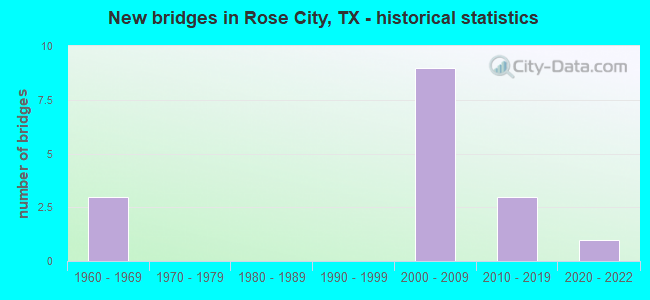
- New bridges - historical statistics
- 31960-1969
- 92000-2009
- 32010-2019
- 12020-2022


- Bridge Condition - Deck
- 12.5%Very good
- 68.8%Good
- 18.8%Satisfactory

- Bridge Condition - Superstructure
- 6.3%Excellent
- 62.5%Very good
- 18.8%Good
- 12.5%Satisfactory

- Bridge Condition - Substructure
- 6.3%Excellent
- 56.3%Good
- 31.3%Satisfactory
- 6.3%Fair

- Bridge Condition - Channel
- 42.9%Very good
- 21.4%Good
- 14.3%Satisfactory
- 7.1%Fair
- 14.3%Serious
Find on map >> Show street view
Structure Number: 201810002809145, Location: 1.20 MI E JEFFERSON C/L (Lat: 30.095450, Lng: -94.077314), Route carried "on" structure: ServiceInterstate 10, Year Built: 1969, Status: Open, Structure Length: 9.33m (30.61ft), Average Daily Traffic: 5,110 (year 2013), Average Future Daily Traffic: 7,160 (year 2033), Features Intersected: BAIRDS BAYOU
Minimum Vertical Clearance: 30+ m (98+ ft), Kilometerpoint: 18.105, Lanes on structure: 2, Owner: State Highway Agency, Approaching Roadway Width: 7.3m (24.0ft), Skew: 3 degrees, Material/Design: Concrete, Design/Construction: Slab, Number Of Spans In Main Unit: 12, Length of Maximum Span: 7.9m (25.9ft), Curb-To-Curb Width: 10.4m (34.1ft), Out-to-Out Width: 11.1m (36.4ft)
Condition: Deck: Satisfactory, Superstructure: Satisfactory, Substructure: Satisfactory, Channel: Satisfactory, Operating Rating: 55.3 metric tons, Method Used To Determine Operating Rating: Load Factor (LF), Inventory Rating: 32.7 metric tons, Method Used To Determine Inventory Rating: Load Factor (LF), Structural Evaluation: Equal to present minimum criteria, Deck Geometry: Somewhat better than minimum adequacy, Waterway Adequacy: Superior to present desirable criteria, Approach Roadway Alignment: Equal to present desirable criteria, Designated Inspection Frequency: Every 24 months, Underwater Inspection Frequency: Every 60 months, Inspection Date: March 2020, Underwater Inspection Date: May 2019, Deck Structure Type: Concrete Cast-file-Place
Find on map >> Show street view
Structure Number: 201810002809146, Location: 1.80 MI E JEFFERSON C/L (Lat: 30.097189, Lng: -94.068144), Route carried "on" structure: ServiceInterstate 10, Year Built: 1969, Status: Open, Structure Length: 7.41m (24.31ft), Average Daily Traffic: 1,070 (year 2013), Average Future Daily Traffic: 1,500 (year 2033), Design Load: H 20, Features Intersected: BAIRDS BAYOU
Minimum Vertical Clearance: 30+ m (98+ ft), Kilometerpoint: 19.010, Lanes on structure: 2, Owner: State Highway Agency, Approaching Roadway Width: 7.3m (24.0ft), Material/Design: Concrete, Design/Construction: Stringer/Multi-beam, Number Of Spans In Main Unit: 8, Length of Maximum Span: 9.1m (29.9ft), Curb-To-Curb Width: 10.2m (33.5ft), Out-to-Out Width: 11.1m (36.4ft)
Condition: Deck: Satisfactory, Superstructure: Satisfactory, Substructure: Satisfactory, Channel: Very good, Operating Rating: 68.0 metric tons, Method Used To Determine Operating Rating: Load Factor (LF), Inventory Rating: 40.8 metric tons, Method Used To Determine Inventory Rating: Load Factor (LF), Structural Evaluation: Equal to present minimum criteria, Deck Geometry: Somewhat better than minimum adequacy, Waterway Adequacy: Meets minimum limits, Approach Roadway Alignment: Equal to present desirable criteria, Designated Inspection Frequency: Every 24 months, Underwater Inspection Frequency: Every 60 months, Inspection Date: March 2020, Underwater Inspection Date: May 2019, Deck Structure Type: Concrete Cast-file-Place
Find on map >> Show street view
Structure Number: 201810002809147, Location: 1.80 MI E JEFFERSON C/L (Lat: 30.097886, Lng: -94.068128), Route carried "on" structure: ServiceInterstate 10, Year Built: 1969, Status: Open, Structure Length: 5.55m (18.21ft), Average Daily Traffic: 5,110 (year 2013), Truck Traffic: 16%, Average Future Daily Traffic: 7,160 (year 2033), Design Load: H 20, Features Intersected: BAIRDS BAYOU
Minimum Vertical Clearance: 30+ m (98+ ft), Kilometerpoint: 19.055, Lanes on structure: 2, Owner: State Highway Agency, Approaching Roadway Width: 7.3m (24.0ft), Material/Design: Concrete, Design/Construction: Stringer/Multi-beam, Number Of Spans In Main Unit: 6, Length of Maximum Span: 9.1m (29.9ft), Curb-To-Curb Width: 10.2m (33.5ft), Out-to-Out Width: 11.1m (36.4ft)
Condition: Deck: Satisfactory, Superstructure: Good, Substructure: Satisfactory, Channel: Satisfactory, Operating Rating: 68.0 metric tons, Method Used To Determine Operating Rating: Load Factor (LF), Inventory Rating: 40.8 metric tons, Method Used To Determine Inventory Rating: Load Factor (LF), Structural Evaluation: Equal to present minimum criteria, Deck Geometry: Somewhat better than minimum adequacy, Waterway Adequacy: Meets minimum limits, Approach Roadway Alignment: Equal to present desirable criteria, Designated Inspection Frequency: Every 24 months, Underwater Inspection Frequency: Every 60 months, Inspection Date: March 2020, Underwater Inspection Date: May 2019, Deck Structure Type: Concrete Cast-file-Place
Find on map >> Show street view
Structure Number: 201810002809237, Location: 2.4 MI E OF JEFFERSON C/L (Lat: 30.102533, Lng: -94.060100), Route carried "on" structure: Interstate 10, Year Built: 2006, Status: Open, Structure Length: 6.80m (22.31ft), Average Daily Traffic: 85,223 (year 2020), Truck Traffic: 16%, Average Future Daily Traffic: 108,690 (year 2033), Design Load: HS 20, Features Intersected: TURNAROUND
Minimum Vertical Clearance: 30+ m (98+ ft), Kilometerpoint: 20.189, Lanes on structure: 6, Lanes under structure: 2, Owner: State Highway Agency, Approaching Roadway Width: 33.5m (109.9ft), Skew: 30 degrees, Material/Design: Prestressed concrete, Design/Construction: Stringer/Multi-beam, Number Of Spans In Main Unit: 2, Number Of Approach Spans: 2, Length of Maximum Span: 21.9m (71.9ft), Curb-To-Curb Width: 33.3m (109.3ft), Out-to-Out Width: 34.8m (114.2ft)
Condition: Deck: Good, Superstructure: Good, Substructure: Good, Operating Rating: 54.4 metric tons, Method Used To Determine Operating Rating: Assigned rating based on Load Factor Design (LFD) reported in metric tons, Inventory Rating: 32.7 metric tons, Method Used To Determine Inventory Rating: Assigned rating based on Load Factor Design (LFD) reported in metric tons, Structural Evaluation: Better than present minimum criteria, Deck Geometry: Superior to present desirable criteria, Approach Roadway Alignment: Equal to present desirable criteria, Designated Inspection Frequency: Every 24 months, Inspection Date: March 2020, Deck Structure Type: Concrete Precast Panels
Find on map >> Show street view
Structure Number: 201810002809238, Location: 3.5 MI E OF JEFFERSON C/L (Lat: 30.112211, Lng: -94.044875), Route carried "on" structure: Interstate 10, Year Built: 2006, Status: Open, Structure Length: 8.69m (28.51ft), Average Daily Traffic: 76,297 (year 2020), Truck Traffic: 16%, Average Future Daily Traffic: 103,310 (year 2033), Design Load: HS 20, Features Intersected: ASHER TURNAROUND
Minimum Vertical Clearance: 30+ m (98+ ft), Kilometerpoint: 21.953, Lanes on structure: 6, Lanes under structure: 2, Owner: State Highway Agency, Approaching Roadway Width: 33.5m (109.9ft), Skew: 30 degrees, Material/Design: Prestressed concrete, Design/Construction: Stringer/Multi-beam, Number Of Spans In Main Unit: 3, Number Of Approach Spans: 2, Length of Maximum Span: 21.9m (71.9ft), Curb-To-Curb Width: 33.2m (108.9ft), Out-to-Out Width: 34.8m (114.2ft)
Condition: Deck: Good, Superstructure: Very good, Substructure: Good, Operating Rating: 54.4 metric tons, Method Used To Determine Operating Rating: Assigned rating based on Load Factor Design (LFD) reported in metric tons, Inventory Rating: 32.7 metric tons, Method Used To Determine Inventory Rating: Assigned rating based on Load Factor Design (LFD) reported in metric tons, Structural Evaluation: Better than present minimum criteria, Deck Geometry: Superior to present desirable criteria, Approach Roadway Alignment: Equal to present desirable criteria, Designated Inspection Frequency: Every 24 months, Inspection Date: March 2020, Deck Structure Type: Concrete Precast Panels
Find on map >> Show street view
Structure Number: 20181000280924, Location: 1.8 MI E OF JEFFERSON C/L (Lat: 30.097342, Lng: -94.068447), Route carried "on" structure: Interstate 10, Year Built: 2006, Status: Open, Structure Length: 13.38m (43.90ft), Average Daily Traffic: 43,055 (year 2020), Truck Traffic: 16%, Average Future Daily Traffic: 54,340 (year 2033), Design Load: HS 20, Features Intersected: BAIRDS BAYOU
Minimum Vertical Clearance: 30+ m (98+ ft), Kilometerpoint: 19.196, Lanes on structure: 3, Owner: State Highway Agency, Approaching Roadway Width: 16.8m (55.1ft), Material/Design: Prestressed concrete, Design/Construction: Stringer/Multi-beam, Number Of Spans In Main Unit: 6, Length of Maximum Span: 25.0m (82.0ft), Curb-To-Curb Width: 16.6m (54.5ft), Out-to-Out Width: 17.4m (57.1ft)
Condition: Deck: Good, Superstructure: Very good, Substructure: Good, Channel: Very good, Operating Rating: 54.4 metric tons, Method Used To Determine Operating Rating: Assigned rating based on Load Factor Design (LFD) reported in metric tons, Inventory Rating: 32.7 metric tons, Method Used To Determine Inventory Rating: Assigned rating based on Load Factor Design (LFD) reported in metric tons, Structural Evaluation: Better than present minimum criteria, Deck Geometry: Equal to present minimum criteria, Waterway Adequacy: Superior to present desirable criteria, Approach Roadway Alignment: Equal to present desirable criteria, Designated Inspection Frequency: Every 24 months, Inspection Date: March 2020, Deck Structure Type: Concrete Precast Panels
Find on map >> Show street view
Structure Number: 201810002809241, Location: 1.5 MI E OF JEFFERSON C/L (Lat: 30.095950, Lng: -94.072200), Route carried "on" structure: Interstate 10, Year Built: 2006, Status: Open, Structure Length: 15.21m (49.90ft), Average Daily Traffic: 43,055 (year 2020), Truck Traffic: 16%, Average Future Daily Traffic: 54,340 (year 2033), Design Load: HS 20, Features Intersected: NECHES RIVER RELIEF
Minimum Vertical Clearance: 30+ m (98+ ft), Kilometerpoint: 18.738, Lanes on structure: 3, Owner: State Highway Agency, Approaching Roadway Width: 16.8m (55.1ft), Material/Design: Prestressed concrete, Design/Construction: Stringer/Multi-beam, Number Of Spans In Main Unit: 6, Number Of Approach Spans: 2, Length of Maximum Span: 22.9m (75.1ft), Curb-To-Curb Width: 16.5m (54.1ft), Out-to-Out Width: 17.4m (57.1ft)
Condition: Deck: Good, Superstructure: Good, Substructure: Good, Channel: Very good, Operating Rating: 54.4 metric tons, Method Used To Determine Operating Rating: Assigned rating based on Load Factor Design (LFD) reported in metric tons, Inventory Rating: 32.7 metric tons, Method Used To Determine Inventory Rating: Assigned rating based on Load Factor Design (LFD) reported in metric tons, Structural Evaluation: Better than present minimum criteria, Deck Geometry: Equal to present minimum criteria, Waterway Adequacy: Superior to present desirable criteria, Approach Roadway Alignment: Equal to present desirable criteria, Designated Inspection Frequency: Every 24 months, Inspection Date: March 2020, Deck Structure Type: Concrete Precast Panels
Find on map >> Show street view
Structure Number: 201810002809242, Location: 1.3 MI E OF NECHES RIVER (Lat: 30.095169, Lng: -94.077092), Route carried "on" structure: Interstate 10, Year Built: 2006, Status: Open, Structure Length: 9.39m (30.81ft), Average Daily Traffic: 43,055 (year 2020), Truck Traffic: 16%, Average Future Daily Traffic: 54,340 (year 2033), Design Load: HS 20, Features Intersected: BAIRDS BAYOU
Minimum Vertical Clearance: 30+ m (98+ ft), Kilometerpoint: 18.326, Lanes on structure: 3, Owner: State Highway Agency, Approaching Roadway Width: 16.8m (55.1ft), Skew: 3 degrees, Material/Design: Prestressed concrete, Design/Construction: Stringer/Multi-beam, Number Of Spans In Main Unit: 4, Length of Maximum Span: 23.5m (77.1ft), Curb-To-Curb Width: 16.6m (54.5ft), Out-to-Out Width: 17.4m (57.1ft)
Condition: Deck: Good, Superstructure: Very good, Substructure: Good, Channel: Good, Operating Rating: 54.4 metric tons, Method Used To Determine Operating Rating: Assigned rating based on Load Factor Design (LFD) reported in metric tons, Inventory Rating: 32.7 metric tons, Method Used To Determine Inventory Rating: Assigned rating based on Load Factor Design (LFD) reported in metric tons, Structural Evaluation: Better than present minimum criteria, Deck Geometry: Equal to present minimum criteria, Waterway Adequacy: Superior to present desirable criteria, Approach Roadway Alignment: Equal to present desirable criteria, Designated Inspection Frequency: Every 24 months, Inspection Date: March 2020, Deck Structure Type: Concrete Precast Panels
Find on map >> Show street view
Structure Number: 201810002809252, Location: 1.8 MI E OF JEFFERSON C/L (Lat: 30.097469, Lng: -94.068517), Route carried "on" structure: Interstate 10, Year Built: 2006, Status: Open, Structure Length: 13.38m (43.90ft), Average Daily Traffic: 42,168 (year 2020), Truck Traffic: 16%, Average Future Daily Traffic: 54,340 (year 2033), Design Load: HS 20, Features Intersected: BAIRDS BAYOU
Minimum Vertical Clearance: 30+ m (98+ ft), Kilometerpoint: 19.196, Lanes on structure: 3, Owner: State Highway Agency, Approaching Roadway Width: 16.8m (55.1ft), Material/Design: Prestressed concrete, Design/Construction: Stringer/Multi-beam, Number Of Spans In Main Unit: 6, Length of Maximum Span: 25.0m (82.0ft), Curb-To-Curb Width: 16.6m (54.5ft), Out-to-Out Width: 17.4m (57.1ft)
Condition: Deck: Good, Superstructure: Very good, Substructure: Good, Channel: Very good, Operating Rating: 54.4 metric tons, Method Used To Determine Operating Rating: Assigned rating based on Load Factor Design (LFD) reported in metric tons, Inventory Rating: 32.7 metric tons, Method Used To Determine Inventory Rating: Assigned rating based on Load Factor Design (LFD) reported in metric tons, Structural Evaluation: Better than present minimum criteria, Deck Geometry: Equal to present minimum criteria, Waterway Adequacy: Superior to present desirable criteria, Approach Roadway Alignment: Equal to present desirable criteria, Designated Inspection Frequency: Every 24 months, Inspection Date: March 2020, Deck Structure Type: Concrete Precast Panels
Find on map >> Show street view
Structure Number: 201810002809253, Location: 1.5 MI E OF JEFFERSON C/L (Lat: 30.096467, Lng: -94.071672), Route carried "on" structure: Interstate 10, Year Built: 2006, Status: Open, Structure Length: 15.21m (49.90ft), Average Daily Traffic: 42,168 (year 2020), Truck Traffic: 16%, Average Future Daily Traffic: 54,340 (year 2033), Design Load: HS 20, Features Intersected: NECHES RIVER RELIEF
Minimum Vertical Clearance: 30+ m (98+ ft), Kilometerpoint: 18.738, Lanes on structure: 3, Owner: State Highway Agency, Approaching Roadway Width: 16.8m (55.1ft), Material/Design: Prestressed concrete, Design/Construction: Stringer/Multi-beam, Number Of Spans In Main Unit: 6, Number Of Approach Spans: 2, Length of Maximum Span: 22.9m (75.1ft), Curb-To-Curb Width: 16.6m (54.5ft), Out-to-Out Width: 17.4m (57.1ft)
Condition: Deck: Good, Superstructure: Very good, Substructure: Good, Channel: Very good, Operating Rating: 54.4 metric tons, Method Used To Determine Operating Rating: Assigned rating based on Load Factor Design (LFD) reported in metric tons, Inventory Rating: 32.7 metric tons, Method Used To Determine Inventory Rating: Assigned rating based on Load Factor Design (LFD) reported in metric tons, Structural Evaluation: Better than present minimum criteria, Deck Geometry: Equal to present minimum criteria, Waterway Adequacy: Superior to present desirable criteria, Approach Roadway Alignment: Equal to present desirable criteria, Designated Inspection Frequency: Every 24 months, Inspection Date: March 2020, Deck Structure Type: Concrete Precast Panels
Find on map >> Show street view
Structure Number: 201810002809254, Location: 1.3 MI E OF NECHES RIVER (Lat: 30.095317, Lng: -94.077203), Route carried "on" structure: Interstate 10, Year Built: 2006, Status: Open, Structure Length: 9.39m (30.81ft), Average Daily Traffic: 42,168 (year 2020), Truck Traffic: 16%, Average Future Daily Traffic: 54,340 (year 2033), Design Load: HS 20, Features Intersected: BAIRDS BAYOU
Minimum Vertical Clearance: 30+ m (98+ ft), Kilometerpoint: 18.314, Lanes on structure: 3, Owner: State Highway Agency, Approaching Roadway Width: 16.8m (55.1ft), Skew: 3 degrees, Material/Design: Prestressed concrete, Design/Construction: Stringer/Multi-beam, Number Of Spans In Main Unit: 4, Length of Maximum Span: 23.5m (77.1ft), Curb-To-Curb Width: 16.6m (54.5ft), Out-to-Out Width: 17.4m (57.1ft)
Condition: Deck: Good, Superstructure: Very good, Substructure: Good, Channel: Good, Operating Rating: 54.4 metric tons, Method Used To Determine Operating Rating: Assigned rating based on Load Factor Design (LFD) reported in metric tons, Inventory Rating: 32.7 metric tons, Method Used To Determine Inventory Rating: Assigned rating based on Load Factor Design (LFD) reported in metric tons, Structural Evaluation: Better than present minimum criteria, Deck Geometry: Equal to present minimum criteria, Waterway Adequacy: Superior to present desirable criteria, Approach Roadway Alignment: Equal to present desirable criteria, Designated Inspection Frequency: Every 24 months, Inspection Date: March 2020, Deck Structure Type: Concrete Precast Panels
Find on map >> Show street view
Structure Number: 201810C00135001, Location: 1.5 MI SW OF FM 105 (Lat: 30.112456, Lng: -94.034892), Route carried "on" structure: City street 767, Year Built: 2002, Status: Open, Structure Length: 5.49m (18.01ft), Average Daily Traffic: 1,075 (year 2016), Truck Traffic: 3%, Average Future Daily Traffic: 1,510 (year 2037), Design Load: HS 20, Features Intersected: TIGER CREEK, Facility Carried by Structure: OLD HWY 90
Minimum Vertical Clearance: 30+ m (98+ ft), Kilometerpoint: 6.845, Lanes on structure: 2, Owner: City or Municipal Highway Agency, Approaching Roadway Width: 6.7m (22.0ft), Material/Design: Prestressed concrete, Design/Construction: Box Beam or Girders - Multiple, Number Of Spans In Main Unit: 3, Length of Maximum Span: 18.3m (60.0ft), Curb-To-Curb Width: 9.1m (29.9ft), Out-to-Out Width: 9.8m (32.2ft)
Condition: Deck: Good, Superstructure: Very good, Substructure: Good, Channel: Good, Operating Rating: 54.4 metric tons, Method Used To Determine Operating Rating: Assigned rating based on Load Factor Design (LFD) reported in metric tons, Inventory Rating: 32.7 metric tons, Method Used To Determine Inventory Rating: Assigned rating based on Load Factor Design (LFD) reported in metric tons, Structural Evaluation: Better than present minimum criteria, Deck Geometry: Somewhat better than minimum adequacy, Waterway Adequacy: Equal to present minimum criteria, Approach Roadway Alignment: Equal to present desirable criteria, Length Of Structure Improvement: 4.88m (16.01ft), Designated Inspection Frequency: Every 24 months, Inspection Date: June 2021, Bridge Improvement Cost: $8,000, Roadway Improvement Cost: $2,000, Total Project Cost: $10,000, Deck Structure Type: Concrete Cast-file-Place
Find on map >> Show street view
Structure Number: 201810G00436006, Location: 3.2 MI SW OF FM 105 (Lat: 30.099739, Lng: -94.058628), Route carried "on" structure: City street , Year Built: 2016, Status: Open, Structure Length: 1.83m (6.00ft), Average Daily Traffic: 549 (year 2016), Truck Traffic: 3%, Average Future Daily Traffic: 770 (year 2037), Design Load: HL 93, Features Intersected: BAIRDS BAYOU RELIEF, Facility Carried by Structure: OLD HWY 90
Minimum Vertical Clearance: 30+ m (98+ ft), Kilometerpoint: 2.253, Lanes on structure: 2, Owner: City or Municipal Highway Agency, Approaching Roadway Width: 6.7m (22.0ft), Material/Design: Prestressed concrete, Design/Construction: Stringer/Multi-beam, Number Of Spans In Main Unit: 1, Length of Maximum Span: 17.7m (58.1ft), Curb-To-Curb Width: 7.1m (23.3ft), Out-to-Out Width: 8.0m (26.2ft)
Condition: Deck: Very good, Superstructure: Very good, Substructure: Satisfactory, Channel: Fair, Operating Rating: 54.4 metric tons, Method Used To Determine Operating Rating: Assigned ratings based on Load and Resistance Factor Design (LRFD) reported in metric tons, Inventory Rating: 32.7 metric tons, Method Used To Determine Inventory Rating: Assigned ratings based on Load and Resistance Factor Design (LRFD) reported in metric tons, Structural Evaluation: Equal to present minimum criteria, Deck Geometry: Meets minimum limits, Waterway Adequacy: Better than present minimum criteria, Approach Roadway Alignment: Equal to present desirable criteria, Designated Inspection Frequency: Every 24 months, Inspection Date: June 2021, Deck Structure Type: Concrete Precast Panels
Find on map >> Show street view
Structure Number: 201810G00436007, Location: 2.8 MI SW OF FM 105 (Lat: 30.104339, Lng: -94.050044), Route carried "on" structure: City street , Year Built: 2016, Status: Closed, Structure Length: 2.13m (6.99ft), Average Daily Traffic: 521 (year 2016), Truck Traffic: 3%, Average Future Daily Traffic: 730 (year 2037), Design Load: HL 93, Features Intersected: BAIRDS BAYOU RELIEF, Facility Carried by Structure: OLD HWY 90
Minimum Vertical Clearance: 30+ m (98+ ft), Kilometerpoint: 3.219, Lanes on structure: 2, Owner: City or Municipal Highway Agency, Approaching Roadway Width: 6.7m (22.0ft), Material/Design: Prestressed concrete, Design/Construction: Stringer/Multi-beam, Number Of Spans In Main Unit: 1, Length of Maximum Span: 20.7m (67.9ft), Curb-To-Curb Width: 7.1m (23.3ft), Out-to-Out Width: 8.0m (26.2ft)
Condition: Deck: Good, Superstructure: Very good, Substructure: Fair, Channel: Serious, Operating Rating: 54.4 metric tons, Method Used To Determine Operating Rating: Assigned ratings based on Load and Resistance Factor Design (LRFD) reported in metric tons, Inventory Rating: 32.7 metric tons, Method Used To Determine Inventory Rating: Assigned ratings based on Load and Resistance Factor Design (LRFD) reported in metric tons, Structural Evaluation: Somewhat better than minimum adequacy, Deck Geometry: Meets minimum limits, Waterway Adequacy: Better than present minimum criteria, Approach Roadway Alignment: Equal to present desirable criteria, Designated Inspection Frequency: Every 24 months, Inspection Date: June 2021, Deck Structure Type: Concrete Precast Panels
Find on map >> Show street view
Structure Number: 201810G00436008, Location: 2.3 MI SW OF FM 105 (Lat: 30.107264, Lng: -94.044589), Route carried "on" structure: City street , Year Built: 2016, Status: Closed, Structure Length: 1.52m (4.99ft), Average Daily Traffic: 684 (year 2016), Truck Traffic: 3%, Average Future Daily Traffic: 960 (year 2037), Design Load: HL 93, Features Intersected: TIGER CREEK TRIBUTARY, Facility Carried by Structure: OLD HWY 90
Minimum Vertical Clearance: 30+ m (98+ ft), Kilometerpoint: 3.862, Lanes on structure: 2, Owner: City or Municipal Highway Agency, Approaching Roadway Width: 6.7m (22.0ft), Material/Design: Prestressed concrete, Number Of Spans In Main Unit: 1, Length of Maximum Span: 14.8m (48.6ft), Curb-To-Curb Width: 7.2m (23.6ft), Out-to-Out Width: 8.0m (26.2ft)
Condition: Deck: Good, Superstructure: Very good, Substructure: Satisfactory, Channel: Serious, Operating Rating: 54.4 metric tons, Method Used To Determine Operating Rating: Assigned ratings based on Load and Resistance Factor Design (LRFD) reported in metric tons, Inventory Rating: 32.7 metric tons, Method Used To Determine Inventory Rating: Assigned ratings based on Load and Resistance Factor Design (LRFD) reported in metric tons, Structural Evaluation: Equal to present minimum criteria, Deck Geometry: Meets minimum limits, Waterway Adequacy: Better than present minimum criteria, Approach Roadway Alignment: Equal to present desirable criteria, Designated Inspection Frequency: Every 24 months, Inspection Date: June 2021, Deck Structure Type: Concrete Cast-file-Place
Find on map >> Show street view
Structure Number: 201810G00436009, Location: .6 MI E OF IH-10 (Lat: 30.094147, Lng: -94.068983), Route carried "on" structure: City street , Year Built: 2021, Status: Open, Structure Length: 21.64m (71.00ft), Average Daily Traffic: 1,735 (year 2020), Truck Traffic: 36%, Average Future Daily Traffic: 2,429 (year 2040), Design Load: HL 93, Features Intersected: BAIRDS BAYOU, Facility Carried by Structure: OLD HWY 90
Minimum Vertical Clearance: 30+ m (98+ ft), Kilometerpoint: 0.966, Lanes on structure: 2, Owner: City or Municipal Highway Agency, Approaching Roadway Width: 9.1m (29.9ft), Material/Design: Prestressed concrete, Number Of Spans In Main Unit: 18, Length of Maximum Span: 12.2m (40.0ft), Curb-To-Curb Width: 9.1m (29.9ft), Out-to-Out Width: 9.8m (32.2ft)
Condition: Deck: Very good, Superstructure: Excellent, Substructure: Excellent, Channel: Very good, Operating Rating: 54.4 metric tons, Method Used To Determine Operating Rating: Assigned ratings based on Load and Resistance Factor Design (LRFD) reported in metric tons, Inventory Rating: 32.7 metric tons, Method Used To Determine Inventory Rating: Assigned ratings based on Load and Resistance Factor Design (LRFD) reported in metric tons, Structural Evaluation: Superior to present desirable criteria, Deck Geometry: Somewhat better than minimum adequacy, Waterway Adequacy: Equal to present desirable criteria, Approach Roadway Alignment: Equal to present desirable criteria, Designated Inspection Frequency: Every 24 months, Inspection Date: July 2021, Deck Structure Type: Concrete Cast-file-Place, Wearing Surface/Protective System: Wearing Surface: Monolithic Concrete