Bridge Statistics for Rosebush, Michigan (MI)
Condition, Traffic, Stress, Structural Evaluation, Project Costs
- National Bridge Inventory (NBI) Statistics
- 33Number of bridges
- 138ft / 42.5mTotal length
- $544,000Total costs
- 181,735Total average daily traffic
- 9,772Total average daily truck traffic
- National Bridge Inventory (NBI) Registered Bridges for Rosebush
- No street view available for this location
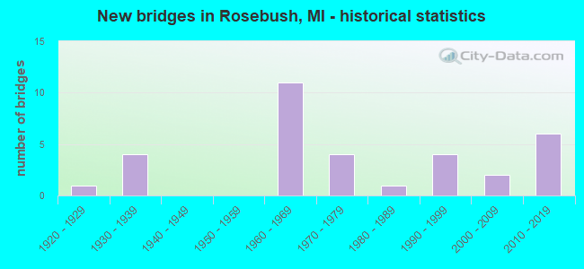
- New bridges - historical statistics
- 11920-1929
- 41930-1939
- 111960-1969
- 41970-1979
- 11980-1989
- 41990-1999
- 22000-2009
- 62010-2019

- Reconstructed bridges - Historical Statistics
- 11950-1959
- 11960-1969
- 01970-1979
- 01980-1989
- 01990-1999
- 22000-2009


- Bridge Condition - Deck
- 13.3%Very good
- 26.7%Good
- 13.3%Satisfactory
- 40.0%Fair
- 6.7%Poor

- Bridge Condition - Superstructure
- 26.7%Very good
- 26.7%Good
- 20.0%Satisfactory
- 13.3%Fair
- 13.3%Poor

- Bridge Condition - Substructure
- 20.0%Very good
- 46.7%Good
- 13.3%Satisfactory
- 6.7%Fair
- 13.3%Poor

- Bridge Condition - Channel
- 11.1%Very good
- 25.9%Good
- 29.6%Satisfactory
- 11.1%Fair
- 22.2%Poor

- Bridge Condition - Culverts
- 20.0%Very good
- 40.0%Good
- 26.7%Satisfactory
- 13.3%Poor
Find on map >> Show street view
Structure Number: 693, Location: 1 MI E OF PINCONNING (Lat: 43.853050, Lng: -83.945906), Route carried "on" structure: County highway 974, Year Built: 1990, Status: Open, Structure Length: 0.79m (2.59ft), Average Daily Traffic: 361 (year 2000), Truck Traffic: 5%, Average Future Daily Traffic: 506 (year 2020), Design Load: HS 20, Features Intersected: PINCONNING RIVER, Facility Carried by Structure: PINCONNING ROAD
Minimum Vertical Clearance: 30.48m (100.00ft), Kilometerpoint: 17.758, Lanes on structure: 2, Owner: County Highway Agency, Approaching Roadway Width: 13.4m (44.0ft), Material/Design: Concrete, Design/Construction: Culvert, Number Of Spans In Main Unit: 1, Length of Maximum Span: 7.3m (24.0ft)
Condition: Channel: Good, Culverts: Good, Operating Rating: 32.7 metric tons, Method Used To Determine Operating Rating: Field evaluation and documented engineering judgment, Inventory Rating: 19.6 metric tons, Method Used To Determine Inventory Rating: Field evaluation and documented engineering judgment, Structural Evaluation: Somewhat better than minimum adequacy, Waterway Adequacy: Better than present minimum criteria, Approach Roadway Alignment: Equal to present desirable criteria, Designated Inspection Frequency: Every 24 months, Inspection Date: April 2020, Deck Structure Type: Concrete Precast Panels, Wearing Surface/Protective System: Wearing Surface: Bituminous
Find on map >> Show street view
Structure Number: 3914, Location: 1.2 MI SE OF STOCKBRIDGE (Lat: 42.439297, Lng: -84.164311), Route carried "on" structure: County highway , Year Built: 2002, Status: Open, Structure Length: 0.73m (2.40ft), Average Daily Traffic: 900 (year 2019), Truck Traffic: 3%, Average Future Daily Traffic: 1,100 (year 2039), Design Load: HS 20, Features Intersected: LOWE LAKE DRAIN, Facility Carried by Structure: GREEN ROAD
Minimum Vertical Clearance: 30.48m (100.00ft), Kilometerpoint: 0.819, Lanes on structure: 2, Owner: County Highway Agency, Approaching Roadway Width: 10.4m (34.1ft), Material/Design: Concrete, Design/Construction: Culvert, Number Of Spans In Main Unit: 1, Length of Maximum Span: 7.3m (24.0ft), Out-to-Out Width: 19.7m (64.6ft)
Condition: Channel: Satisfactory, Culverts: Good, Operating Rating: 43.6 metric tons, Method Used To Determine Operating Rating: Field evaluation and documented engineering judgment, Inventory Rating: 32.7 metric tons, Method Used To Determine Inventory Rating: Field evaluation and documented engineering judgment, Structural Evaluation: Better than present minimum criteria, Waterway Adequacy: Equal to present desirable criteria, Approach Roadway Alignment: Equal to present desirable criteria, Designated Inspection Frequency: Every 24 months, Inspection Date: June 2021, Bridge Improvement Cost: $5,000, Total Project Cost: $5,000, Wearing Surface/Protective System: Wearing Surface: Gravel
Find on map >> Show street view
Structure Number: 4242, Location: IN ROSEBUSH (Lat: 43.706683, Lng: -84.757956), Route carried "on" structure: US 127, Year Built: 1961, Status: Open, Structure Length: 0.91m (2.99ft), Average Daily Traffic: 8,152 (year 2007), Truck Traffic: 10%, Average Future Daily Traffic: 10,395 (year 2018), Design Load: HS 20, Features Intersected: SPRING CREEK
Minimum Vertical Clearance: 30.48m (100.00ft), Kilometerpoint: 30.276, Lanes on structure: 2, Base Highway Network: Yes (Inventory Route: 24, Subroute: 3), Owner: State Highway Agency, Approaching Roadway Width: 15.2m (49.9ft), Skew: 2 degrees, Material/Design: Steel, Design/Construction: Stringer/Multi-beam, Number Of Spans In Main Unit: 1, Length of Maximum Span: 9.1m (29.9ft), Curb-To-Curb Width: 13.1m (43.0ft), Out-to-Out Width: 14.3m (46.9ft)
Condition: Deck: Fair, Superstructure: Satisfactory, Substructure: Good, Channel: Poor, Operating Rating: 76.5 metric tons, Method Used To Determine Operating Rating: Load Factor (LF) rating reported by rating factor (RF) method using MS18 loading, Inventory Rating: 45.7 metric tons, Method Used To Determine Inventory Rating: Load Factor (LF) rating reported by rating factor (RF) method using MS18 loading, Structural Evaluation: Equal to present minimum criteria, Deck Geometry: Superior to present desirable criteria, Waterway Adequacy: Equal to present desirable criteria, Approach Roadway Alignment: Equal to present desirable criteria, Designated Inspection Frequency: Every 24 months, Inspection Date: March 2021, Deck Structure Type: Concrete Cast-file-Place, Wearing Surface/Protective System: Wearing Surface: Bituminous
Find on map >> Show street view
Structure Number: 4243, Location: IN ROSEBUSH (Lat: 43.706839, Lng: -84.758264), Route carried "on" structure: US 127, Year Built: 1961, Status: Open, Structure Length: 0.91m (2.99ft), Average Daily Traffic: 8,152 (year 2007), Truck Traffic: 10%, Average Future Daily Traffic: 10,395 (year 2018), Design Load: HS 20, Features Intersected: SPRING CREEK
Minimum Vertical Clearance: 30.48m (100.00ft), Kilometerpoint: 30.405, Lanes on structure: 2, Base Highway Network: Yes (Inventory Route: 24, Subroute: 6), Owner: State Highway Agency, Approaching Roadway Width: 15.2m (49.9ft), Skew: 2 degrees, Material/Design: Steel, Design/Construction: Stringer/Multi-beam, Number Of Spans In Main Unit: 1, Length of Maximum Span: 9.1m (29.9ft), Curb-To-Curb Width: 13.1m (43.0ft), Out-to-Out Width: 14.3m (46.9ft)
Condition: Deck: Fair, Superstructure: Satisfactory, Substructure: Good, Channel: Poor, Operating Rating: 60.6 metric tons, Method Used To Determine Operating Rating: Load Factor (LF) rating reported by rating factor (RF) method using MS18 loading, Inventory Rating: 36.3 metric tons, Method Used To Determine Inventory Rating: Load Factor (LF) rating reported by rating factor (RF) method using MS18 loading, Structural Evaluation: Equal to present minimum criteria, Deck Geometry: Superior to present desirable criteria, Waterway Adequacy: Equal to present desirable criteria, Approach Roadway Alignment: Better than present minimum criteria, Designated Inspection Frequency: Every 24 months, Inspection Date: March 2021, Deck Structure Type: Concrete Cast-file-Place, Wearing Surface/Protective System: Wearing Surface: Bituminous
Find on map >> Show street view
Structure Number: 4246, Location: 1.0 MI N OF BEAL CITY RD (Lat: 43.683728, Lng: -84.757600), Route carried "on" structure: US 127, Year Built: 1961, Status: Open, Structure Length: 0.61m (2.00ft), Average Daily Traffic: 8,625 (year 2007), Truck Traffic: 9%, Average Future Daily Traffic: 12,174 (year 2018), Design Load: HS 20+Mod, Features Intersected: LEWIS DRAIN
Minimum Vertical Clearance: 30.48m (100.00ft), Kilometerpoint: 27.817, Lanes on structure: 2, Base Highway Network: Yes (Inventory Route: 24, Subroute: 6), Owner: State Highway Agency, Approaching Roadway Width: 11.0m (36.1ft), Material/Design: Concrete, Design/Construction: Culvert, Number Of Spans In Main Unit: 2, Length of Maximum Span: 2.9m (9.5ft), Out-to-Out Width: 20.0m (65.6ft)
Condition: Channel: Fair, Culverts: Satisfactory, Operating Rating: 97.2 metric tons, Method Used To Determine Operating Rating: Load Factor (LF) rating reported by rating factor (RF) method using MS18 loading, Inventory Rating: 97.2 metric tons, Method Used To Determine Inventory Rating: Load Factor (LF) rating reported by rating factor (RF) method using MS18 loading, Structural Evaluation: Equal to present minimum criteria, Waterway Adequacy: Equal to present minimum criteria, Approach Roadway Alignment: Equal to present minimum criteria, Length Of Structure Improvement: 0.58m (1.90ft), Designated Inspection Frequency: Every 24 months, Inspection Date: April 2021, Bridge Improvement Cost: $23,000, Roadway Improvement Cost: $2,000, Total Project Cost: $26,000 ( Estimate for 2050)
Find on map >> Show street view
Structure Number: 4247, Location: 1.0 MI N OF BEAL CITY RD (Lat: 43.683731, Lng: -84.756653), Route carried "on" structure: US 127, Year Built: 1961, Status: Open, Structure Length: 0.61m (2.00ft), Average Daily Traffic: 8,625 (year 2007), Truck Traffic: 9%, Average Future Daily Traffic: 12,174 (year 2018), Design Load: HS 20+Mod, Features Intersected: LEWIS DRAIN
Minimum Vertical Clearance: 30.48m (100.00ft), Kilometerpoint: 27.704, Lanes on structure: 2, Base Highway Network: Yes (Inventory Route: 24, Subroute: 3), Owner: State Highway Agency, Approaching Roadway Width: 11.0m (36.1ft), Material/Design: Concrete, Design/Construction: Culvert, Number Of Spans In Main Unit: 2, Length of Maximum Span: 2.9m (9.5ft), Out-to-Out Width: 20.3m (66.6ft)
Condition: Channel: Very good, Culverts: Satisfactory, Operating Rating: 97.2 metric tons, Method Used To Determine Operating Rating: Load Factor (LF) rating reported by rating factor (RF) method using MS18 loading, Inventory Rating: 97.2 metric tons, Method Used To Determine Inventory Rating: Load Factor (LF) rating reported by rating factor (RF) method using MS18 loading, Structural Evaluation: Equal to present minimum criteria, Waterway Adequacy: Equal to present minimum criteria, Approach Roadway Alignment: Equal to present minimum criteria, Length Of Structure Improvement: 0.58m (1.90ft), Designated Inspection Frequency: Every 24 months, Inspection Date: April 2021, Bridge Improvement Cost: $23,000, Roadway Improvement Cost: $2,000, Total Project Cost: $26,000 ( Estimate for 2050)
Find on map >> Show street view
Structure Number: 4257, Location: IN ROSEBUSH (Lat: 43.698439, Lng: -84.758950), Route carried "on" structure: City street 3762, Year Built: 1961, Status: Open, Structure Length: 6.46m (21.19ft), Average Daily Traffic: 3,138 (year 1997), Truck Traffic: 3%, Average Future Daily Traffic: 840 (year 1977), Design Load: HS 20, Features Intersected: US-127, Facility Carried by Structure: ROSEBUSH RD
Minimum Vertical Clearance: 30.48m (100.00ft), Kilometerpoint: 16.088, Lanes on structure: 2, Lanes under structure: 4, Owner: State Highway Agency, Approaching Roadway Width: 11.0m (36.1ft), Material/Design: Steel, Design/Construction: Stringer/Multi-beam, Number Of Spans In Main Unit: 4, Length of Maximum Span: 21.4m (70.2ft), Curb-To-Curb Width: 9.6m (31.5ft), Out-to-Out Width: 10.6m (34.8ft)
Condition: Deck: Satisfactory, Superstructure: Fair, Substructure: Good, Operating Rating: 62.2 metric tons, Method Used To Determine Operating Rating: Load Factor (LF) rating reported by rating factor (RF) method using MS18 loading, Inventory Rating: 37.3 metric tons, Method Used To Determine Inventory Rating: Load Factor (LF) rating reported by rating factor (RF) method using MS18 loading, Structural Evaluation: Somewhat better than minimum adequacy, Deck Geometry: Meets minimum limits, Underclear: Somewhat better than minimum adequacy, Approach Roadway Alignment: Better than present minimum criteria, Designated Inspection Frequency: Every 24 months, Inspection Date: April 2021, Deck Structure Type: Concrete Cast-file-Place, Wearing Surface/Protective System: Wearing Surface: Epoxy Overlay
Find on map >> Show street view
Structure Number: 4264, Location: 4.5 MI W OF US-27BR (Lat: 43.597039, Lng: -84.854958), Route carried "on" structure: State highway 20, Year Built: 1934, Year Reconstructed: 1964, Status: Open, Structure Length: 1.52m (4.99ft), Average Daily Traffic: 8,359 (year 2007), Truck Traffic: 4%, Average Future Daily Traffic: 9,678 (year 2018), Design Load: HS 20, Features Intersected: N BR CHIPPEWA RIVER
Minimum Vertical Clearance: 30.48m (100.00ft), Kilometerpoint: 18.658, Lanes on structure: 2, Base Highway Network: Yes (Inventory Route: 24, Subroute: 1), Owner: State Highway Agency, Approaching Roadway Width: 12.2m (40.0ft), Material/Design: Steel, Design/Construction: Stringer/Multi-beam, Number Of Spans In Main Unit: 1, Length of Maximum Span: 15.2m (49.9ft), Curb or Sidewalk Widths: Left: 0.1m (0.3ft), Right: 0.1m (0.3ft), Curb-To-Curb Width: 12.5m (41.0ft), Out-to-Out Width: 13.2m (43.3ft)
Condition: Deck: Fair, Superstructure: Good, Substructure: Satisfactory, Channel: Poor, Operating Rating: 73.2 metric tons, Method Used To Determine Operating Rating: Load Factor (LF) rating reported by rating factor (RF) method using MS18 loading, Inventory Rating: 43.7 metric tons, Method Used To Determine Inventory Rating: Load Factor (LF) rating reported by rating factor (RF) method using MS18 loading, Structural Evaluation: Equal to present minimum criteria, Deck Geometry: Somewhat better than minimum adequacy, Waterway Adequacy: Equal to present desirable criteria, Approach Roadway Alignment: Better than present minimum criteria, Designated Inspection Frequency: Every 24 months, Inspection Date: March 2021, Deck Structure Type: Concrete Cast-file-Place, Wearing Surface/Protective System: Wearing Surface: Latex Concrete
Find on map >> Show street view
Structure Number: 4286, Location: 0.3 M W NE COR SEC 14 T15 (Lat: 43.698450, Lng: -84.755008), Route carried "on" structure: County highway 3762, Year Built: 1999, Status: Open, Structure Length: 0.91m (2.99ft), Average Daily Traffic: 1,860 (year 2002), Average Future Daily Traffic: 2,760 (year 2022), Design Load: HS 20, Features Intersected: SPRING CREEK, Facility Carried by Structure: ROSEBUSH ROAD
Minimum Vertical Clearance: 30.48m (100.00ft), Kilometerpoint: 16.405, Lanes on structure: 2, Owner: County Highway Agency, Approaching Roadway Width: 8.5m (27.9ft), Material/Design: Concrete, Design/Construction: Culvert, Number Of Spans In Main Unit: 1, Length of Maximum Span: 9.1m (29.9ft), Curb-To-Curb Width: 11.9m (39.0ft), Out-to-Out Width: 12.5m (41.0ft)
Condition: Channel: Poor, Culverts: Very good, Operating Rating: 43.4 metric tons, Method Used To Determine Operating Rating: Field evaluation and documented engineering judgment, Inventory Rating: 32.7 metric tons, Method Used To Determine Inventory Rating: Field evaluation and documented engineering judgment, Structural Evaluation: Equal to present desirable criteria, Deck Geometry: Equal to present minimum criteria, Waterway Adequacy: Better than present minimum criteria, Approach Roadway Alignment: Better than present minimum criteria, Designated Inspection Frequency: Every 24 months, Inspection Date: May 2020, Wearing Surface/Protective System: Wearing Surface: Bituminous
Find on map >> Show street view
Structure Number: 4307, Location: 0.1M N SE COR SEC 18 T15N (Lat: 43.685933, Lng: -84.707911), Route carried "on" structure: County highway , Year Built: 2014, Status: Open, Structure Length: 1.52m (4.99ft), Average Daily Traffic: 1,308 (year 2013), Truck Traffic: 2%, Average Future Daily Traffic: 1,596 (year 2033), Design Load: Greater than HL93, Features Intersected: SPRING CREEK, Facility Carried by Structure: LEATON ROAD
Minimum Vertical Clearance: 30.48m (100.00ft), Kilometerpoint: 14.918, Lanes on structure: 2, Owner: County Highway Agency, Approaching Roadway Width: 11.0m (36.1ft), Material/Design: Prestressed concrete, Design/Construction: Stringer/Multi-beam, Number Of Spans In Main Unit: 1, Length of Maximum Span: 14.5m (47.6ft), Curb-To-Curb Width: 11.0m (36.1ft), Out-to-Out Width: 12.1m (39.7ft)
Condition: Deck: Very good, Superstructure: Very good, Substructure: Very good, Channel: Very good, Operating Rating: 68.4 metric tons, Method Used To Determine Operating Rating: Load and Resistance Factor Rating (LRFR) rating reported by rating factor(RF) method using HL-93 loadings, Inventory Rating: 49.9 metric tons, Method Used To Determine Inventory Rating: Load and Resistance Factor Rating (LRFR) rating reported by rating factor(RF) method using HL-93 loadings, Structural Evaluation: Equal to present desirable criteria, Deck Geometry: Equal to present minimum criteria, Waterway Adequacy: Better than present minimum criteria, Approach Roadway Alignment: Better than present minimum criteria, Designated Inspection Frequency: Every 24 months, Inspection Date: July 2020, Deck Structure Type: Concrete Cast-file-Place, Wearing Surface/Protective System: Wearing Surface: Monolithic Concrete, Deck Protection: Epoxy Coated Reinforcing
Find on map >> Show street view
Structure Number: 4308, Location: 0.1M S NW COR SEC 11 T15N (Lat: 43.711308, Lng: -84.767803), Route carried "on" structure: County highway 3767, Year Built: 1935, Status: Open, Structure Length: 0.85m (2.79ft), Average Daily Traffic: 5,200 (year 2002), Average Future Daily Traffic: 7,720 (year 2022), Design Load: H 15, Features Intersected: SPRING CREEK, Facility Carried by Structure: MISSION ROAD
Minimum Vertical Clearance: 30.48m (100.00ft), Kilometerpoint: 10.506, Lanes on structure: 2, Owner: County Highway Agency, Approaching Roadway Width: 11.0m (36.1ft), Material/Design: Concrete, Design/Construction: Tee Beam, Number Of Spans In Main Unit: 1, Length of Maximum Span: 7.3m (24.0ft), Curb-To-Curb Width: 10.4m (34.1ft), Out-to-Out Width: 11.8m (38.7ft)
Condition: Deck: Fair, Superstructure: Good, Substructure: Poor, Channel: Fair, Operating Rating: 44.5 metric tons, Method Used To Determine Operating Rating: Field evaluation and documented engineering judgment, Inventory Rating: 28.2 metric tons, Method Used To Determine Inventory Rating: Field evaluation and documented engineering judgment, Structural Evaluation: Meets minimum limits, Deck Geometry: Meets minimum limits, Waterway Adequacy: Better than present minimum criteria, Approach Roadway Alignment: Equal to present desirable criteria, Length Of Structure Improvement: 1.46m (4.79ft), Designated Inspection Frequency: Every 12 months, Inspection Date: June 2021, Bridge Improvement Cost: $122,000, Roadway Improvement Cost: $13,000, Total Project Cost: $135,000, Deck Structure Type: Concrete Cast-file-Place, Wearing Surface/Protective System: Wearing Surface: Bituminous
Find on map >> Show street view
Structure Number: 4311, Location: 0.2M S NE COR SEC 22 T15N (Lat: 43.680169, Lng: -84.767692), Route carried "on" structure: County highway 3767, Year Built: 1930, Status: Open, Structure Length: 0.70m (2.30ft), Average Daily Traffic: 6,140 (year 2002), Average Future Daily Traffic: 9,120 (year 2022), Design Load: H 15, Features Intersected: LEWIS DRAIN, Facility Carried by Structure: MISSION ROAD
Minimum Vertical Clearance: 30.48m (100.00ft), Kilometerpoint: 7.048, Lanes on structure: 2, Owner: County Highway Agency, Approaching Roadway Width: 11.0m (36.1ft), Material/Design: Concrete, Design/Construction: Tee Beam, Number Of Spans In Main Unit: 1, Length of Maximum Span: 6.1m (20.0ft), Curb-To-Curb Width: 11.0m (36.1ft), Out-to-Out Width: 11.8m (38.7ft)
Condition: Deck: Fair, Superstructure: Poor, Substructure: Fair, Channel: Poor, Operating Rating: 48.0 metric tons, Method Used To Determine Operating Rating: Load Factor (LF) rating reported by rating factor (RF) method using MS18 loading, Inventory Rating: 28.8 metric tons, Method Used To Determine Inventory Rating: Load Factor (LF) rating reported by rating factor (RF) method using MS18 loading, Structural Evaluation: Meets minimum limits, Deck Geometry: Meets minimum limits, Waterway Adequacy: Better than present minimum criteria, Approach Roadway Alignment: Equal to present desirable criteria, Length Of Structure Improvement: 1.22m (4.00ft), Designated Inspection Frequency: Every 12 months, Inspection Date: May 2021, Bridge Improvement Cost: $100,000, Roadway Improvement Cost: $10,000, Total Project Cost: $150,000, Deck Structure Type: Concrete Cast-file-Place, Wearing Surface/Protective System: Wearing Surface: Bituminous
Find on map >> Show street view
Structure Number: 4351, Location: SEC 17-20 DENVER TWP (Lat: 43.684414, Lng: -84.704128), Route carried "on" structure: County highway , Year Built: 1981, Status: Open, Structure Length: 0.94m (3.08ft), Average Daily Traffic: 196 (year 2002), Average Future Daily Traffic: 240 (year 2022), Design Load: HS 20, Features Intersected: SPRING CREEK, Facility Carried by Structure: WEIDMAN ROAD
Minimum Vertical Clearance: 30.48m (100.00ft), Kilometerpoint: 3.534, Lanes on structure: 2, Owner: County Highway Agency, Approaching Roadway Width: 9.1m (29.9ft), Skew: 1 degrees, Material/Design: Steel, Design/Construction: Culvert, Number Of Spans In Main Unit: 1, Length of Maximum Span: 8.5m (27.9ft), Curb-To-Curb Width: 10.1m (33.1ft), Out-to-Out Width: 10.3m (33.8ft)
Condition: Channel: Satisfactory, Culverts: Poor, Operating Rating: 49.6 metric tons, Method Used To Determine Operating Rating: Load Factor (LF) rating reported by rating factor (RF) method using MS18 loading, Inventory Rating: 29.8 metric tons, Method Used To Determine Inventory Rating: Load Factor (LF) rating reported by rating factor (RF) method using MS18 loading, Structural Evaluation: Meets minimum limits, Deck Geometry: Better than present minimum criteria, Waterway Adequacy: Equal to present desirable criteria, Approach Roadway Alignment: Equal to present desirable criteria, Designated Inspection Frequency: Every 12 months, Inspection Date: May 2021
Find on map >> Show street view
Structure Number: 4353, Location: SEC 30W DENVER TWP (Lat: 43.661519, Lng: -84.727969), Route carried "on" structure: ServiceCounty highway , Year Built: 1994, Status: Open, Structure Length: 1.52m (4.99ft), Average Daily Traffic: 113 (year 2002), Average Future Daily Traffic: 138 (year 2022), Design Load: HS 20, Features Intersected: JORDAN CREEK, Facility Carried by Structure: SUMMERTON ROAD
Minimum Vertical Clearance: 30.48m (100.00ft), Kilometerpoint: 2.985, Lanes on structure: 2, Owner: County Highway Agency, Approaching Roadway Width: 8.8m (28.9ft), Material/Design: Prestressed concrete, Design/Construction: Box Beam or Girders - Multiple, Number Of Spans In Main Unit: 1, Length of Maximum Span: 14.0m (45.9ft), Curb-To-Curb Width: 9.1m (29.9ft), Out-to-Out Width: 9.4m (30.8ft)
Condition: Deck: Good, Superstructure: Good, Substructure: Very good, Channel: Good, Operating Rating: 54.1 metric tons, Method Used To Determine Operating Rating: Load Factor (LF), Inventory Rating: 32.4 metric tons, Method Used To Determine Inventory Rating: Load Factor (LF), Structural Evaluation: Better than present minimum criteria, Deck Geometry: Equal to present minimum criteria, Waterway Adequacy: Better than present minimum criteria, Approach Roadway Alignment: Equal to present desirable criteria, Designated Inspection Frequency: Every 24 months, Inspection Date: May 2020, Deck Structure Type: Concrete Precast Panels, Wearing Surface/Protective System: Wearing Surface: Bituminous
Find on map >> Show street view
Structure Number: 4354, Location: SEC 18 W DENVER TWP (Lat: 43.692097, Lng: -84.727983), Route carried "on" structure: County highway , Year Built: 1937, Status: Posted for load, Structure Length: 1.09m (3.58ft), Average Daily Traffic: 185 (year 2002), Average Future Daily Traffic: 225 (year 2022), Design Load: H 15, Features Intersected: CONTRIB S BR SALT RIVER, Facility Carried by Structure: SUMMERTON ROAD
Minimum Vertical Clearance: 30.48m (100.00ft), Kilometerpoint: 6.381, Lanes on structure: 2, Owner: County Highway Agency, Approaching Roadway Width: 6.7m (22.0ft), Material/Design: Steel, Design/Construction: Stringer/Multi-beam, Number Of Spans In Main Unit: 1, Length of Maximum Span: 9.7m (31.8ft), Curb-To-Curb Width: 6.1m (20.0ft), Out-to-Out Width: 6.7m (22.0ft)
Condition: Deck: Poor, Superstructure: Poor, Substructure: Poor, Channel: Poor, Operating Rating: 29.5 metric tons, Method Used To Determine Operating Rating: Load Factor (LF) rating reported by rating factor (RF) method using MS18 loading, Inventory Rating: 17.5 metric tons, Method Used To Determine Inventory Rating: Load Factor (LF) rating reported by rating factor (RF) method using MS18 loading, Structural Evaluation: Meets minimum limits, Deck Geometry: Meets minimum limits, Waterway Adequacy: Somewhat better than minimum adequacy, Approach Roadway Alignment: Equal to present minimum criteria, Bridge Posting: Required (Relationship of Operating Rating to Maximum Legal Load: > 39.9% below), Length Of Structure Improvement: 1.77m (5.81ft), Designated Inspection Frequency: Every 12 months, Inspection Date: June 2021, Bridge Improvement Cost: $120,000, Roadway Improvement Cost: $11,000, Total Project Cost: $172,000, Deck Structure Type: Other, Wearing Surface/Protective System: Wearing Surface: Monolithic Concrete
Find on map >> Show street view
Structure Number: 436, Location: SEC 13-14 ISABELLA TWP (Lat: 43.685464, Lng: -84.747947), Route carried "on" structure: ServiceCounty highway , Year Built: 2006, Status: Open, Structure Length: 0.79m (2.59ft), Average Daily Traffic: 185 (year 2002), Average Future Daily Traffic: 225 (year 2022), Design Load: HS 20, Features Intersected: SOUTH BR SALT RIVER, Facility Carried by Structure: ISABELLA ROAD
Minimum Vertical Clearance: 30.48m (100.00ft), Kilometerpoint: 13.498, Lanes on structure: 2, Owner: County Highway Agency, Approaching Roadway Width: 9.1m (29.9ft), Material/Design: Concrete, Design/Construction: Culvert, Number Of Spans In Main Unit: 1, Length of Maximum Span: 7.9m (25.9ft), Curb-To-Curb Width: 9.1m (29.9ft), Out-to-Out Width: 18.3m (60.0ft)
Condition: Channel: Good, Culverts: Good, Operating Rating: 43.6 metric tons, Method Used To Determine Operating Rating: Field evaluation and documented engineering judgment, Inventory Rating: 32.7 metric tons, Method Used To Determine Inventory Rating: Field evaluation and documented engineering judgment, Structural Evaluation: Better than present minimum criteria, Deck Geometry: Equal to present minimum criteria, Waterway Adequacy: Somewhat better than minimum adequacy, Approach Roadway Alignment: Equal to present desirable criteria, Designated Inspection Frequency: Every 24 months, Inspection Date: May 2021, Deck Structure Type: Concrete Precast Panels, Wearing Surface/Protective System: Wearing Surface: Bituminous
Find on map >> Show street view
Structure Number: 4361, Location: .28 M S NE COR SEC 14 T15 (Lat: 43.694333, Lng: -84.747906), Route carried "on" structure: County highway , Year Built: 1978, Status: Open, Structure Length: 1.09m (3.58ft), Average Daily Traffic: 192 (year 2002), Average Future Daily Traffic: 234 (year 2022), Design Load: HS 20, Features Intersected: SPRING CREEK, Facility Carried by Structure: ISABELLA ROAD
Minimum Vertical Clearance: 30.48m (100.00ft), Kilometerpoint: 14.483, Lanes on structure: 2, Owner: County Highway Agency, Approaching Roadway Width: 10.4m (34.1ft), Material/Design: Prestressed concrete, Design/Construction: Box Beam or Girders - Multiple, Number Of Spans In Main Unit: 1, Length of Maximum Span: 9.7m (31.8ft), Curb-To-Curb Width: 10.1m (33.1ft), Out-to-Out Width: 10.2m (33.5ft)
Condition: Deck: Good, Superstructure: Very good, Substructure: Good, Channel: Satisfactory, Operating Rating: 71.4 metric tons, Method Used To Determine Operating Rating: Load Factor (LF), Inventory Rating: 42.8 metric tons, Method Used To Determine Inventory Rating: Load Factor (LF), Structural Evaluation: Better than present minimum criteria, Deck Geometry: Better than present minimum criteria, Waterway Adequacy: Better than present minimum criteria, Approach Roadway Alignment: Equal to present desirable criteria, Designated Inspection Frequency: Every 24 months, Inspection Date: June 2020, Deck Structure Type: Concrete Precast Panels, Wearing Surface/Protective System: Wearing Surface: Bituminous, Membrane: Other
Find on map >> Show street view
Structure Number: 4465, Location: 3.0 MI S OF N CO LINE (Lat: 42.378658, Lng: -84.429128), Route carried "on" structure: US 127, Year Built: 1966, Year Reconstructed: 2007, Status: Open, Structure Length: 3.38m (11.09ft), Average Daily Traffic: 10,196 (year 2007), Truck Traffic: 10%, Average Future Daily Traffic: 11,527 (year 2018), Design Load: HS 20, Features Intersected: BERRY RD
Minimum Vertical Clearance: 30.48m (100.00ft), Kilometerpoint: 11.874, Lanes on structure: 2, Lanes under structure: 2, Base Highway Network: Yes (Inventory Route: 338, Subroute: 14), Owner: State Highway Agency, Approaching Roadway Width: 12.2m (40.0ft), Skew: 10 degrees, Material/Design: Steel, Design/Construction: Stringer/Multi-beam, Number Of Spans In Main Unit: 3, Length of Maximum Span: 14.9m (48.9ft), Curb-To-Curb Width: 11.6m (38.1ft), Out-to-Out Width: 12.8m (42.0ft)
Condition: Deck: Satisfactory, Superstructure: Satisfactory, Substructure: Good, Operating Rating: 64.2 metric tons, Method Used To Determine Operating Rating: Load Factor (LF) rating reported by rating factor (RF) method using MS18 loading, Inventory Rating: 38.6 metric tons, Method Used To Determine Inventory Rating: Load Factor (LF) rating reported by rating factor (RF) method using MS18 loading, Structural Evaluation: Equal to present minimum criteria, Deck Geometry: Better than present minimum criteria, Underclear: Somewhat better than minimum adequacy, Approach Roadway Alignment: Equal to present desirable criteria, Designated Inspection Frequency: Every 16 months, Inspection Date: May 2021, Deck Structure Type: Concrete Cast-file-Place, Wearing Surface/Protective System: Wearing Surface: Latex Concrete
Find on map >> Show street view
Structure Number: 4466, Location: 0.8 MI S OF CO LINE (Lat: 42.411483, Lng: -84.428989), Route carried "on" structure: US 127, Year Built: 1966, Year Reconstructed: 2007, Status: Open, Structure Length: 3.21m (10.53ft), Average Daily Traffic: 9,599 (year 2007), Truck Traffic: 10%, Average Future Daily Traffic: 11,527 (year 2018), Design Load: HS 20, Features Intersected: TERRITORIAL RD
Minimum Vertical Clearance: 30.48m (100.00ft), Kilometerpoint: 15.656, Lanes on structure: 2, Lanes under structure: 2, Base Highway Network: Yes (Inventory Route: 89, Subroute: 2), Owner: State Highway Agency, Approaching Roadway Width: 12.2m (40.0ft), Skew: 10 degrees, Material/Design: Steel, Design/Construction: Stringer/Multi-beam, Number Of Spans In Main Unit: 3, Length of Maximum Span: 12.8m (42.0ft), Curb-To-Curb Width: 11.6m (38.1ft), Out-to-Out Width: 12.8m (42.0ft)
Condition: Deck: Fair, Superstructure: Fair, Substructure: Satisfactory, Operating Rating: 62.2 metric tons, Method Used To Determine Operating Rating: Load Factor (LF) rating reported by rating factor (RF) method using MS18 loading, Inventory Rating: 37.3 metric tons, Method Used To Determine Inventory Rating: Load Factor (LF) rating reported by rating factor (RF) method using MS18 loading, Structural Evaluation: Somewhat better than minimum adequacy, Deck Geometry: Better than present minimum criteria, Underclear: Somewhat better than minimum adequacy, Approach Roadway Alignment: Equal to present desirable criteria, Designated Inspection Frequency: Every 16 months, Inspection Date: May 2021, Deck Structure Type: Concrete Cast-file-Place, Wearing Surface/Protective System: Wearing Surface: Latex Concrete
Find on map >> Show street view
Structure Number: 5029, Location: 0.50 MILE E OF ALPINE AVE (Lat: 43.072731, Lng: -85.679572), Route carried "on" structure: County highway , Year Built: 1964, Status: Open, Structure Length: 1.09m (3.58ft), Average Daily Traffic: 4,784 (year 2005), Average Future Daily Traffic: 8,130 (year 2025), Design Load: HS 20+Mod, Features Intersected: MILL CREEK, Facility Carried by Structure: 7 MILE ROAD
Minimum Vertical Clearance: 30.48m (100.00ft), Kilometerpoint: 8.013, Lanes on structure: 2, Owner: County Highway Agency, Approaching Roadway Width: 12.2m (40.0ft), Material/Design: Steel, Design/Construction: Culvert, Number Of Spans In Main Unit: 2, Length of Maximum Span: 5.4m (17.7ft)
Condition: Channel: Very good, Culverts: Very good, Operating Rating: 40.2 metric tons, Method Used To Determine Operating Rating: Load Factor (LF) rating reported by rating factor (RF) method using MS18 loading, Inventory Rating: 33.4 metric tons, Method Used To Determine Inventory Rating: Load Factor (LF) rating reported by rating factor (RF) method using MS18 loading, Structural Evaluation: Equal to present desirable criteria, Waterway Adequacy: Equal to present desirable criteria, Approach Roadway Alignment: Equal to present desirable criteria, Designated Inspection Frequency: Every 24 months, Inspection Date: October 2021
Find on map >> Show street view
Structure Number: 5031, Location: 0.90 MI E OF WOLVERINE (Lat: 43.117864, Lng: -85.530936), Route carried "on" structure: County highway 4162, Year Built: 1971, Status: Open, Structure Length: 0.64m (2.10ft), Average Daily Traffic: 20,162 (year 2005), Average Future Daily Traffic: 34,280 (year 2025), Design Load: HS 20+Mod, Features Intersected: RUM CREEK, Facility Carried by Structure: 10 MILE RD
Minimum Vertical Clearance: 30.48m (100.00ft), Kilometerpoint: 2.334, Lanes on structure: 2, Owner: County Highway Agency, Approaching Roadway Width: 12.2m (40.0ft), Material/Design: Steel, Design/Construction: Culvert, Number Of Spans In Main Unit: 2, Length of Maximum Span: 2.7m (8.9ft)
Condition: Channel: Good, Culverts: Satisfactory, Operating Rating: 97.2 metric tons, Method Used To Determine Operating Rating: Load Factor (LF) rating reported by rating factor (RF) method using MS18 loading, Inventory Rating: 97.2 metric tons, Method Used To Determine Inventory Rating: Load Factor (LF) rating reported by rating factor (RF) method using MS18 loading, Structural Evaluation: Equal to present minimum criteria, Waterway Adequacy: Equal to present desirable criteria, Approach Roadway Alignment: Equal to present desirable criteria, Designated Inspection Frequency: Every 24 months, Inspection Date: October 2020
Find on map >> Show street view
Structure Number: 5032, Location: 0.35 MI W OF PHELPS AVE (Lat: 43.160603, Lng: -85.737792), Route carried "on" structure: County highway 4170, Year Built: 1974, Status: Open, Structure Length: 1.28m (4.20ft), Average Daily Traffic: 3,386 (year 2005), Average Future Daily Traffic: 5,760 (year 2025), Design Load: HS 20+Mod, Features Intersected: NASH CREEK, Facility Carried by Structure: 13 MILE RD
Minimum Vertical Clearance: 30.48m (100.00ft), Kilometerpoint: 4.252, Lanes on structure: 2, Owner: County Highway Agency, Approaching Roadway Width: 13.4m (44.0ft), Material/Design: Steel, Design/Construction: Culvert, Number Of Spans In Main Unit: 3, Length of Maximum Span: 3.6m (11.8ft)
Condition: Channel: Satisfactory, Culverts: Satisfactory, Operating Rating: 50.5 metric tons, Method Used To Determine Operating Rating: Load Factor (LF) rating reported by rating factor (RF) method using MS18 loading, Inventory Rating: 44.1 metric tons, Method Used To Determine Inventory Rating: Load Factor (LF) rating reported by rating factor (RF) method using MS18 loading, Structural Evaluation: Equal to present minimum criteria, Waterway Adequacy: Equal to present desirable criteria, Approach Roadway Alignment: Equal to present minimum criteria, Designated Inspection Frequency: Every 24 months, Inspection Date: October 2021
Find on map >> Show street view
Structure Number: 5034, Location: 0.20 MI W OF ALPINE AVE (Lat: 43.160547, Lng: -85.689525), Route carried "on" structure: County highway 4170, Year Built: 1922, Year Reconstructed: 1969, Status: Open, Structure Length: 1.82m (5.97ft), Average Daily Traffic: 8,792 (year 2005), Average Future Daily Traffic: 14,950 (year 2025), Design Load: HS 20+Mod, Features Intersected: ROGUE RIVER, Facility Carried by Structure: 13 MILE RD
Minimum Vertical Clearance: 30.48m (100.00ft), Kilometerpoint: 8.179, Lanes on structure: 2, Owner: County Highway Agency, Approaching Roadway Width: 13.4m (44.0ft), Skew: 1 degrees, Material/Design: Prestressed concrete, Design/Construction: Box Beam or Girders - Multiple, Number Of Spans In Main Unit: 1, Length of Maximum Span: 16.7m (54.8ft), Curb-To-Curb Width: 14.9m (48.9ft), Out-to-Out Width: 16.0m (52.5ft)
Condition: Deck: Good, Superstructure: Good, Substructure: Good, Channel: Good, Operating Rating: 69.6 metric tons, Method Used To Determine Operating Rating: Load Factor (LF), Inventory Rating: 41.7 metric tons, Method Used To Determine Inventory Rating: Load Factor (LF), Structural Evaluation: Better than present minimum criteria, Deck Geometry: Superior to present desirable criteria, Waterway Adequacy: Equal to present desirable criteria, Approach Roadway Alignment: Equal to present desirable criteria, Length Of Structure Improvement: 3.00m (9.84ft), Designated Inspection Frequency: Every 24 months, Inspection Date: October 2021, Bridge Improvement Cost: $30,000, Total Project Cost: $30,000, Deck Structure Type: Concrete Precast Panels, Wearing Surface/Protective System: Wearing Surface: Bituminous
Find on map >> Show street view
Structure Number: 6259, Location: 0.3 MI N OF 25 MILE ROAD (Lat: 42.706308, Lng: -82.959275), Route carried "on" structure: County highway 2058, Year Built: 1997, Status: Open, Structure Length: 3.54m (11.61ft), Average Daily Traffic: 9,180 (year 2007), Truck Traffic: 6%, Average Future Daily Traffic: 16,579 (year 2027), Design Load: HS 25 or greater, Features Intersected: M B CLINTON RIVER, Facility Carried by Structure: ROMEO PLANK RD
Minimum Vertical Clearance: 30.48m (100.00ft), Kilometerpoint: 0.616, Lanes on structure: 2, Owner: County Highway Agency, Approaching Roadway Width: 13.0m (42.7ft), Skew: 1 degrees, Material/Design: Prestressed concrete, Design/Construction: Stringer/Multi-beam, Number Of Spans In Main Unit: 2, Length of Maximum Span: 16.9m (55.4ft), Curb-To-Curb Width: 13.0m (42.7ft), Out-to-Out Width: 14.4m (47.2ft)
Condition: Deck: Good, Superstructure: Very good, Substructure: Good, Channel: Satisfactory, Operating Rating: 72.3 metric tons, Method Used To Determine Operating Rating: Load Factor (LF) rating reported by rating factor (RF) method using MS18 loading, Inventory Rating: 43.1 metric tons, Method Used To Determine Inventory Rating: Load Factor (LF) rating reported by rating factor (RF) method using MS18 loading, Structural Evaluation: Better than present minimum criteria, Deck Geometry: Somewhat better than minimum adequacy, Waterway Adequacy: Superior to present desirable criteria, Approach Roadway Alignment: Equal to present desirable criteria, Designated Inspection Frequency: Every 24 months, Inspection Date: June 2021, Deck Structure Type: Concrete Cast-file-Place, Wearing Surface/Protective System: Wearing Surface: Monolithic Concrete, Deck Protection: Epoxy Coated Reinforcing
Find on map >> Show street view
Structure Number: 13876, Location: 0.9 MI W OF MISSION ROAD (Lat: 43.684083, Lng: -84.785361), Route carried "on" structure: County highway 3758, Year Built: 2014, Status: Open, Structure Length: 0.78m (2.56ft), Average Daily Traffic: 3,530 (year 2002), Truck Traffic: 2%, Average Future Daily Traffic: 5,240 (year 2022), Design Load: HS 20, Features Intersected: LEWIS DRAIN, Facility Carried by Structure: WEIDMAN ROAD
Minimum Vertical Clearance: 30.48m (100.00ft), Kilometerpoint: 18.067, Lanes on structure: 2, Owner: County Highway Agency, Approaching Roadway Width: 9.8m (32.2ft), Skew: 3 degrees, Material/Design: Concrete, Design/Construction: Culvert, Number Of Spans In Main Unit: 1, Length of Maximum Span: 7.1m (23.3ft), Curb-To-Curb Width: 9.1m (29.9ft), Out-to-Out Width: 23.2m (76.1ft)
Condition: Channel: Satisfactory, Culverts: Good, Operating Rating: 43.4 metric tons, Method Used To Determine Operating Rating: Load and Resistance Factor Rating (LRFR) rating reported by rating factor(RF) method using HL-93 loadings, Inventory Rating: 33.4 metric tons, Method Used To Determine Inventory Rating: Load and Resistance Factor Rating (LRFR) rating reported by rating factor(RF) method using HL-93 loadings, Structural Evaluation: Better than present minimum criteria, Deck Geometry: Meets minimum limits, Waterway Adequacy: Equal to present desirable criteria, Approach Roadway Alignment: Equal to present minimum criteria, Designated Inspection Frequency: Every 24 months, Inspection Date: May 2021, Wearing Surface/Protective System: Wearing Surface: Bituminous
Find on map >> Show street view
Structure Number: 13877, Location: 0.6 MI W OF MISSION ROAD (Lat: 43.683917, Lng: -84.779861), Route carried "on" structure: County highway 3758, Year Built: 2014, Status: Open, Structure Length: 0.73m (2.40ft), Average Daily Traffic: 3,530 (year 2002), Truck Traffic: 2%, Average Future Daily Traffic: 5,240 (year 2022), Design Load: HS 20, Features Intersected: LEWIS DRAIN, Facility Carried by Structure: WEIDMAN ROAD
Minimum Vertical Clearance: 30.48m (100.00ft), Kilometerpoint: 18.511, Lanes on structure: 2, Owner: County Highway Agency, Approaching Roadway Width: 9.8m (32.2ft), Material/Design: Concrete, Design/Construction: Culvert, Number Of Spans In Main Unit: 1, Length of Maximum Span: 6.7m (22.0ft), Curb-To-Curb Width: 9.8m (32.2ft), Out-to-Out Width: 19.5m (64.0ft)
Condition: Channel: Good, Culverts: Good, Operating Rating: 44.7 metric tons, Method Used To Determine Operating Rating: Load and Resistance Factor Rating (LRFR) rating reported by rating factor(RF) method using HL-93 loadings, Inventory Rating: 34.7 metric tons, Method Used To Determine Inventory Rating: Load and Resistance Factor Rating (LRFR) rating reported by rating factor(RF) method using HL-93 loadings, Structural Evaluation: Better than present minimum criteria, Deck Geometry: Meets minimum limits, Waterway Adequacy: Equal to present desirable criteria, Approach Roadway Alignment: Equal to present minimum criteria, Designated Inspection Frequency: Every 24 months, Inspection Date: May 2021, Wearing Surface/Protective System: Wearing Surface: Bituminous
Find on map >> Show street view
Structure Number: 13879, Location: 0.6 MI S OF WEIDMAN ROAD (Lat: 43.675694, Lng: -84.727972), Route carried "on" structure: County highway , Year Built: 2014, Status: Open, Structure Length: 0.98m (3.22ft), Average Daily Traffic: 185 (year 2002), Average Future Daily Traffic: 225 (year 2022), Design Load: HS 20, Features Intersected: LEWIS DRAIN, Facility Carried by Structure: SUMMERTON ROAD
Minimum Vertical Clearance: 30.48m (100.00ft), Kilometerpoint: 4.572, Lanes on structure: 2, Owner: County Highway Agency, Approaching Roadway Width: 7.0m (23.0ft), Skew: 3 degrees, Material/Design: Concrete, Design/Construction: Culvert, Number Of Spans In Main Unit: 1, Length of Maximum Span: 9.1m (29.9ft), Curb-To-Curb Width: 7.0m (23.0ft), Out-to-Out Width: 23.2m (76.1ft)
Condition: Channel: Satisfactory, Culverts: Very good, Operating Rating: 81.6 metric tons, Method Used To Determine Operating Rating: Load and Resistance Factor Rating (LRFR) rating reported by rating factor(RF) method using HL-93 loadings, Inventory Rating: 62.9 metric tons, Method Used To Determine Inventory Rating: Load and Resistance Factor Rating (LRFR) rating reported by rating factor(RF) method using HL-93 loadings, Structural Evaluation: Equal to present desirable criteria, Deck Geometry: Meets minimum limits, Waterway Adequacy: Superior to present desirable criteria, Approach Roadway Alignment: Equal to present minimum criteria, Designated Inspection Frequency: Every 24 months, Inspection Date: May 2021, Wearing Surface/Protective System: Wearing Surface: Gravel
Find on map >> Show street view
Structure Number: 1388, Location: 0.2 MI E OF MISSION ROAD (Lat: 43.683639, Lng: -84.763600), Route carried "on" structure: County highway , Year Built: 2019, Status: Open, Structure Length: 1.22m (4.00ft), Average Daily Traffic: 198 (year 2018), Average Future Daily Traffic: 240 (year 2038), Design Load: Greater than HL93, Features Intersected: LEWIS DRAIN, Facility Carried by Structure: WEIDMAN ROAD
Minimum Vertical Clearance: 30.48m (100.00ft), Kilometerpoint: 19.812, Lanes on structure: 2, Owner: County Highway Agency, Approaching Roadway Width: 8.7m (28.5ft), Skew: 3 degrees, Material/Design: Prestressed concrete, Design/Construction: Box Beam or Girders - Multiple, Number Of Spans In Main Unit: 1, Length of Maximum Span: 11.7m (38.4ft), Curb-To-Curb Width: 8.9m (29.2ft), Out-to-Out Width: 9.7m (31.8ft)
Condition: Deck: Very good, Superstructure: Very good, Substructure: Very good, Channel: Satisfactory, Operating Rating: 58.0 metric tons, Method Used To Determine Operating Rating: Load and Resistance Factor Rating (LRFR) rating reported by rating factor(RF) method using HL-93 loadings, Inventory Rating: 44.7 metric tons, Method Used To Determine Inventory Rating: Load and Resistance Factor Rating (LRFR) rating reported by rating factor(RF) method using HL-93 loadings, Structural Evaluation: Equal to present desirable criteria, Deck Geometry: Equal to present minimum criteria, Waterway Adequacy: Equal to present desirable criteria, Approach Roadway Alignment: Equal to present desirable criteria, Designated Inspection Frequency: Every 24 months, Inspection Date: May 2021, Deck Structure Type: Concrete Cast-file-Place, Wearing Surface/Protective System: Wearing Surface: Monolithic Concrete, Deck Protection: Epoxy Coated Reinforcing
Find on map >> Show street view
Structure Number: 13881, Location: 0.1 MI E OF ISABELLA ROAD (Lat: 43.683833, Lng: -84.745889), Route carried "on" structure: County highway , Year Built: 2014, Status: Open, Structure Length: 0.89m (2.92ft), Average Daily Traffic: 196 (year 2002), Average Future Daily Traffic: 240 (year 2022), Design Load: HS 20, Features Intersected: LEWIS DRAIN, Facility Carried by Structure: WEIDMAN ROAD
Minimum Vertical Clearance: 30.48m (100.00ft), Kilometerpoint: 0.169, Lanes on structure: 2, Owner: County Highway Agency, Approaching Roadway Width: 8.5m (27.9ft), Skew: 2 degrees, Material/Design: Concrete, Design/Construction: Culvert, Number Of Spans In Main Unit: 1, Length of Maximum Span: 8.2m (26.9ft), Curb-To-Curb Width: 8.5m (27.9ft), Out-to-Out Width: 18.3m (60.0ft)
Condition: Channel: Good, Culverts: Good, Operating Rating: 57.7 metric tons, Method Used To Determine Operating Rating: Load and Resistance Factor Rating (LRFR) rating reported by rating factor(RF) method using HL-93 loadings, Inventory Rating: 44.7 metric tons, Method Used To Determine Inventory Rating: Load and Resistance Factor Rating (LRFR) rating reported by rating factor(RF) method using HL-93 loadings, Structural Evaluation: Better than present minimum criteria, Deck Geometry: Equal to present minimum criteria, Waterway Adequacy: Superior to present desirable criteria, Approach Roadway Alignment: Equal to present minimum criteria, Designated Inspection Frequency: Every 24 months, Inspection Date: May 2021, Wearing Surface/Protective System: Wearing Surface: Gravel
Find on map >> Show street view
Structure Number: 14002, Location: 0.37 MI S BEAL CITY ROAD (Lat: 43.664528, Lng: -84.708028), Route carried "on" structure: County highway , Year Built: 1970, Status: Open, Structure Length: 0.94m (3.08ft), Average Daily Traffic: 100 (year 2017), Average Future Daily Traffic: 100 (year 2037), Design Load: H 20, Features Intersected: JORDAN CREEK, Facility Carried by Structure: LEATON ROAD
Minimum Vertical Clearance: 30.48m (100.00ft), Kilometerpoint: 12.539, Lanes on structure: 2, Owner: County Highway Agency, Approaching Roadway Width: 7.3m (24.0ft), Material/Design: Steel, Design/Construction: Culvert, Number Of Spans In Main Unit: 2, Length of Maximum Span: 4.3m (14.1ft), Curb-To-Curb Width: 7.3m (24.0ft), Out-to-Out Width: 27.1m (88.9ft)
Condition: Channel: Fair, Culverts: Poor, Operating Rating: 88.8 metric tons, Method Used To Determine Operating Rating: Load Factor (LF) rating reported by rating factor (RF) method using MS18 loading, Inventory Rating: 53.1 metric tons, Method Used To Determine Inventory Rating: Load Factor (LF) rating reported by rating factor (RF) method using MS18 loading, Structural Evaluation: Meets minimum limits, Deck Geometry: Equal to present minimum criteria, Waterway Adequacy: Somewhat better than minimum adequacy, Approach Roadway Alignment: Equal to present minimum criteria, Designated Inspection Frequency: Every 12 months, Inspection Date: July 2021, Wearing Surface/Protective System: Wearing Surface: Bituminous
Find on map >> Show street view
Structure Number: 4256, Location: 3.1 MI N OF US-127BR (Lat: 43.669153, Lng: -84.758386), Route carried "under" structure: US 127, Year Built: 1964, Structure Length: 0. m, Average Daily Traffic: 15,174 (year 2013), Truck Traffic: 6%, Features Intersected: US-127, Facility Carried by Structure: BEAL CITY RD
Minimum Vertical Clearance: 4.50m (14.76ft), Kilometerpoint: 26.071, Lanes on structure: 2, Lanes under structure: 4, Material/Design: Prestressed concrete, Design/Construction: Stringer/Multi-beam, Length of Maximum Span: 23.0m (75.5ft)
Find on map >> Show street view
Structure Number: 4257, Location: IN ROSEBUSH (Lat: 43.698439, Lng: -84.758950), Route carried "under" structure: US 127, Year Built: 1961, Structure Length: 0. m, Average Daily Traffic: 14,728 (year 2013), Truck Traffic: 6%, Features Intersected: US-127, Facility Carried by Structure: ROSEBUSH RD
Minimum Vertical Clearance: 4.55m (14.93ft), Kilometerpoint: 29.352, Lanes on structure: 2, Lanes under structure: 4, Material/Design: Steel, Design/Construction: Stringer/Multi-beam, Length of Maximum Span: 21.4m (70.2ft)
Find on map >> Show street view
Structure Number: 4258, Location: 6.1 MI S OF US-10 (Lat: 43.727936, Lng: -84.758308), Route carried "under" structure: US 127, Year Built: 1965, Structure Length: 0. m, Average Daily Traffic: 16,304 (year 2007), Truck Traffic: 10%, Features Intersected: US-127, Facility Carried by Structure: VERNON RD
Minimum Vertical Clearance: 4.42m (14.50ft), Kilometerpoint: 32.658, Lanes on structure: 2, Lanes under structure: 4, Material/Design: Prestressed concrete, Design/Construction: Stringer/Multi-beam, Length of Maximum Span: 21.6m (70.9ft)