Bridge Statistics for Roseland, Indiana (IN)
Condition, Traffic, Stress, Structural Evaluation, Project Costs
- National Bridge Inventory (NBI) Statistics
- 14Number of bridges
- 131ft / 39.7mTotal length
- 260,267Total average daily traffic
- 13,918Total average daily truck traffic
- National Bridge Inventory (NBI) Registered Bridges for Roseland
- No street view available for this location
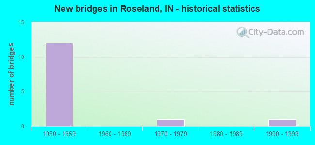
- New bridges - historical statistics
- 121950-1959
- 11970-1979
- 11990-1999

- Reconstructed bridges - Historical Statistics
- 21990-1999
- 02000-2009
- 52010-2019


- Bridge Condition - Deck
- 25.0%Excellent
- 25.0%Very good
- 25.0%Good
- 12.5%Satisfactory
- 12.5%Fair

- Bridge Condition - Superstructure
- 12.5%Good
- 75.0%Satisfactory
- 12.5%Fair

- Bridge Condition - Channel
- 25.0%Very good
- 75.0%Good
Find on map >> Show street view
Structure Number: 11051, Location: 00.03 S I-90 (Lat: 41.722000, Lng: -86.250511), Route carried "on" structure: State highway 933, Year Built: 1995, Status: Open, Structure Length: 1.80m (5.91ft), Average Daily Traffic: 25,652 (year 2018), Truck Traffic: 10%, Average Future Daily Traffic: 25,331 (year 2030), Design Load: HS 20, Features Intersected: JUDAY CREEK
Minimum Vertical Clearance: 30+ m (98+ ft), Kilometerpoint: 22.643, Lanes on structure: 5, Owner: State Highway Agency, Approaching Roadway Width: 20.4m (66.9ft), Material/Design: Concrete continuous, Design/Construction: Slab, Number Of Spans In Main Unit: 3, Length of Maximum Span: 6.7m (22.0ft), Curb or Sidewalk Widths: Left: 1.7m (5.6ft), Right: 1.7m (5.6ft), Curb-To-Curb Width: 20.4m (66.9ft), Out-to-Out Width: 24.7m (81.0ft)
Condition: Deck: Fair, Superstructure: Fair, Substructure: Good, Channel: Very good, Operating Rating: 52.5 metric tons, Method Used To Determine Operating Rating: Load and Resistance Factor Rating (LRFR) rating reported by rating factor(RF) method using HL-93 loadings, Inventory Rating: 40.5 metric tons, Method Used To Determine Inventory Rating: Load and Resistance Factor Rating (LRFR) rating reported by rating factor(RF) method using HL-93 loadings, Structural Evaluation: Somewhat better than minimum adequacy, Deck Geometry: Somewhat better than minimum adequacy, Waterway Adequacy: Equal to present desirable criteria, Approach Roadway Alignment: Equal to present desirable criteria, Designated Inspection Frequency: Every 24 months, Inspection Date: April 2021, Deck Structure Type: Concrete Cast-file-Place, Wearing Surface/Protective System: Wearing Surface: Monolithic Concrete, Deck Protection: Epoxy Coated Reinforcing
Find on map >> Show street view
Structure Number: 4771, Location: 00.13 W SR 933 (Lat: 41.722511, Lng: -86.255797), Route carried "on" structure: Interstate 90, Year Built: 1956, Year Reconstructed: 2017, Status: Open, Structure Length: 4.72m (15.49ft), Average Daily Traffic: 14,480 (year 2015), Truck Traffic: 5%, Average Future Daily Traffic: 32,885 (year 2031), Design Load: HS 20+Mod, Features Intersected: I-90 RAMP-EXIT #77 NB/SB
Minimum Vertical Clearance: 30+ m (98+ ft), Kilometerpoint: 123.211, Lanes on structure: 2, Lanes under structure: 2, Base Highway Network: Yes (, Subroute: 1), Toll: On toll road, Owner: State Toll Authority, Approaching Roadway Width: 12.8m (42.0ft), Material/Design: Steel, Design/Construction: Stringer/Multi-beam, Number Of Spans In Main Unit: 3, Length of Maximum Span: 18.3m (60.0ft), Curb-To-Curb Width: 11.5m (37.7ft), Out-to-Out Width: 12.4m (40.7ft)
Condition: Deck: Excellent, Superstructure: Satisfactory, Substructure: Good, Operating Rating: 71.2 metric tons, Method Used To Determine Operating Rating: Load Factor (LF), Inventory Rating: 42.6 metric tons, Method Used To Determine Inventory Rating: Load Factor (LF), Structural Evaluation: Equal to present minimum criteria, Deck Geometry: Somewhat better than minimum adequacy, Underclear: Somewhat better than minimum adequacy, Approach Roadway Alignment: Equal to present desirable criteria, Designated Inspection Frequency: Every 24 months, Inspection Date: August 2021, Deck Structure Type: Concrete Cast-file-Place, Wearing Surface/Protective System: Wearing Surface: Latex Concrete
Find on map >> Show street view
Structure Number: 4772, Location: 00.13 W SR 933 (Lat: 41.722761, Lng: -86.255858), Route carried "on" structure: Interstate 90, Year Built: 1956, Year Reconstructed: 2017, Status: Open, Structure Length: 4.72m (15.49ft), Average Daily Traffic: 14,240 (year 2004), Truck Traffic: 5%, Average Future Daily Traffic: 32,885 (year 2031), Design Load: HS 20+Mod, Features Intersected: I-90 RAMP-EXIT #77 NB/SB
Minimum Vertical Clearance: 30+ m (98+ ft), Kilometerpoint: 123.211, Lanes on structure: 3, Lanes under structure: 2, Base Highway Network: Yes (, Subroute: 1), Toll: On toll road, Owner: State Toll Authority, Approaching Roadway Width: 12.8m (42.0ft), Material/Design: Steel, Design/Construction: Stringer/Multi-beam, Number Of Spans In Main Unit: 3, Length of Maximum Span: 18.3m (60.0ft), Curb-To-Curb Width: 15.9m (52.2ft), Out-to-Out Width: 18.5m (60.7ft)
Condition: Deck: Very good, Superstructure: Satisfactory, Substructure: Good, Operating Rating: 74.3 metric tons, Method Used To Determine Operating Rating: Load Factor (LF), Inventory Rating: 44.5 metric tons, Method Used To Determine Inventory Rating: Load Factor (LF), Structural Evaluation: Equal to present minimum criteria, Deck Geometry: Somewhat better than minimum adequacy, Underclear: Somewhat better than minimum adequacy, Approach Roadway Alignment: Equal to present desirable criteria, Designated Inspection Frequency: Every 24 months, Inspection Date: August 2021, Deck Structure Type: Concrete Cast-file-Place, Wearing Surface/Protective System: Wearing Surface: Latex Concrete
Find on map >> Show street view
Structure Number: 4775, Location: 00.13 W SR 933 (Lat: 41.722581, Lng: -86.252892), Route carried "on" structure: Interstate 90, Year Built: 1956, Year Reconstructed: 2018, Status: Open, Structure Length: 6.04m (19.82ft), Average Daily Traffic: 14,240 (year 2004), Truck Traffic: 5%, Average Future Daily Traffic: 32,885 (year 2031), Design Load: HS 20+Mod, Features Intersected: MCCOMBS ST, LASALLE TR
Minimum Vertical Clearance: 30+ m (98+ ft), Kilometerpoint: 123.453, Lanes on structure: 3, Lanes under structure: 2, Base Highway Network: Yes (, Subroute: 1), Toll: On toll road, Owner: State Toll Authority, Approaching Roadway Width: 12.8m (42.0ft), Material/Design: Steel, Design/Construction: Stringer/Multi-beam, Number Of Spans In Main Unit: 3, Length of Maximum Span: 23.2m (76.1ft), Curb-To-Curb Width: 16.9m (55.4ft), Out-to-Out Width: 17.8m (58.4ft)
Condition: Deck: Excellent, Superstructure: Satisfactory, Substructure: Good, Operating Rating: 88.7 metric tons, Method Used To Determine Operating Rating: Load Factor (LF), Inventory Rating: 53.1 metric tons, Method Used To Determine Inventory Rating: Load Factor (LF), Structural Evaluation: Equal to present minimum criteria, Deck Geometry: Equal to present minimum criteria, Underclear: Meets minimum limits, Approach Roadway Alignment: Equal to present desirable criteria, Designated Inspection Frequency: Every 24 months, Inspection Date: August 2021, Deck Structure Type: Concrete Cast-file-Place, Wearing Surface/Protective System: Wearing Surface: Latex Concrete
Find on map >> Show street view
Structure Number: 4776, Location: 00.13 W SR 933 (Lat: 41.722819, Lng: -86.252892), Route carried "on" structure: Interstate 90, Year Built: 1956, Year Reconstructed: 2018, Status: Open, Structure Length: 6.04m (19.82ft), Average Daily Traffic: 14,240 (year 2004), Truck Traffic: 5%, Average Future Daily Traffic: 32,885 (year 2031), Design Load: HS 20+Mod, Features Intersected: MCCOMBS ST, LASALLE TR
Minimum Vertical Clearance: 30+ m (98+ ft), Kilometerpoint: 123.453, Lanes on structure: 2, Lanes under structure: 2, Base Highway Network: Yes (, Subroute: 1), Toll: On toll road, Owner: State Toll Authority, Approaching Roadway Width: 12.8m (42.0ft), Material/Design: Steel, Design/Construction: Stringer/Multi-beam, Number Of Spans In Main Unit: 3, Length of Maximum Span: 23.2m (76.1ft), Curb-To-Curb Width: 11.5m (37.7ft), Out-to-Out Width: 12.4m (40.7ft)
Condition: Deck: Very good, Superstructure: Satisfactory, Substructure: Good, Operating Rating: 87.2 metric tons, Method Used To Determine Operating Rating: Load Factor (LF), Inventory Rating: 52.2 metric tons, Method Used To Determine Inventory Rating: Load Factor (LF), Structural Evaluation: Equal to present minimum criteria, Deck Geometry: Somewhat better than minimum adequacy, Underclear: Meets minimum limits, Approach Roadway Alignment: Equal to present desirable criteria, Designated Inspection Frequency: Every 24 months, Inspection Date: August 2021, Deck Structure Type: Concrete Cast-file-Place, Wearing Surface/Protective System: Wearing Surface: Latex Concrete
Find on map >> Show street view
Structure Number: 47762, Location: 00.06 W SR 933 (Lat: 41.722511, Lng: -86.251664), Route carried "on" structure: Interstate 90, Year Built: 1957, Status: Open, Structure Length: 0.75m (2.46ft), Average Daily Traffic: 28,480 (year 2004), Truck Traffic: 5%, Average Future Daily Traffic: 56,734 (year 2030), Design Load: HS 20, Features Intersected: JUDAY CREEK
Minimum Vertical Clearance: 30+ m (98+ ft), Kilometerpoint: 123.533, Lanes on structure: 4, Base Highway Network: Yes (, Subroute: 1), Toll: On toll road, Owner: State Toll Authority, Approaching Roadway Width: 37.8m (124.0ft), Skew: 13 degrees, Material/Design: Concrete, Design/Construction: Culvert, Number Of Spans In Main Unit: 1, Length of Maximum Span: 7.5m (24.6ft)
Condition: Channel: Good, Culverts: Satisfactory, Operating Rating: 65.3 metric tons, Method Used To Determine Operating Rating: Load Factor (LF), Inventory Rating: 65.3 metric tons, Method Used To Determine Inventory Rating: Load Factor (LF), Structural Evaluation: Equal to present minimum criteria, Waterway Adequacy: Equal to present desirable criteria, Approach Roadway Alignment: Equal to present minimum criteria, Designated Inspection Frequency: Every 24 months, Inspection Date: July 2021
Find on map >> Show street view
Structure Number: 4777, Location: 02.92 W SR 23 (Lat: 41.722511, Lng: -86.250511), Route carried "on" structure: Interstate 90, Year Built: 1956, Year Reconstructed: 1990, Status: Open, Structure Length: 6.95m (22.80ft), Average Daily Traffic: 14,240 (year 2011), Truck Traffic: 5%, Average Future Daily Traffic: 32,885 (year 2031), Design Load: HS 20, Features Intersected: SR 933
Minimum Vertical Clearance: 30+ m (98+ ft), Kilometerpoint: 123.662, Lanes on structure: 3, Lanes under structure: 4, Base Highway Network: Yes (, Subroute: 1), Toll: On toll road, Owner: State Toll Authority, Approaching Roadway Width: 12.8m (42.0ft), Material/Design: Steel continuous, Design/Construction: Stringer/Multi-beam, Number Of Spans In Main Unit: 3, Length of Maximum Span: 29.0m (95.1ft), Curb-To-Curb Width: 15.5m (50.9ft), Out-to-Out Width: 16.4m (53.8ft)
Condition: Deck: Satisfactory, Superstructure: Satisfactory, Substructure: Good, Operating Rating: 55.1 metric tons, Method Used To Determine Operating Rating: Load Factor (LF), Inventory Rating: 33.0 metric tons, Method Used To Determine Inventory Rating: Load Factor (LF), Structural Evaluation: Equal to present minimum criteria, Deck Geometry: Somewhat better than minimum adequacy, Underclear: Equal to present minimum criteria, Approach Roadway Alignment: Equal to present desirable criteria, Designated Inspection Frequency: Every 24 months, Inspection Date: August 2021, Deck Structure Type: Concrete Cast-file-Place, Wearing Surface/Protective System: Wearing Surface: Latex Concrete
Find on map >> Show street view
Structure Number: 4778, Location: 02.92 W SR 23 (Lat: 41.722750, Lng: -86.250525), Route carried "on" structure: Interstate 90, Year Built: 1956, Year Reconstructed: 1990, Status: Open, Structure Length: 6.95m (22.80ft), Average Daily Traffic: 14,240 (year 2004), Truck Traffic: 5%, Average Future Daily Traffic: 32,885 (year 2031), Design Load: HS 20, Features Intersected: SR 933
Minimum Vertical Clearance: 30+ m (98+ ft), Kilometerpoint: 123.662, Lanes on structure: 2, Lanes under structure: 4, Base Highway Network: Yes (, Subroute: 1), Toll: On toll road, Owner: State Toll Authority, Approaching Roadway Width: 12.8m (42.0ft), Material/Design: Steel continuous, Design/Construction: Stringer/Multi-beam, Number Of Spans In Main Unit: 3, Length of Maximum Span: 29.0m (95.1ft), Curb-To-Curb Width: 11.8m (38.7ft), Out-to-Out Width: 12.7m (41.7ft)
Condition: Deck: Good, Superstructure: Satisfactory, Substructure: Good, Operating Rating: 38.2 metric tons, Method Used To Determine Operating Rating: Load and Resistance Factor Rating (LRFR) rating reported by rating factor(RF) method using HL-93 loadings, Inventory Rating: 29.5 metric tons, Method Used To Determine Inventory Rating: Load and Resistance Factor Rating (LRFR) rating reported by rating factor(RF) method using HL-93 loadings, Structural Evaluation: Equal to present minimum criteria, Deck Geometry: Equal to present minimum criteria, Underclear: Equal to present minimum criteria, Approach Roadway Alignment: Equal to present desirable criteria, Designated Inspection Frequency: Every 24 months, Inspection Date: August 2021, Deck Structure Type: Concrete Cast-file-Place, Wearing Surface/Protective System: Wearing Surface: Latex Concrete
Find on map >> Show street view
Structure Number: 47782, Location: 00.40 W JUNIPER RD (Lat: 41.718489, Lng: -86.242392), Route carried "on" structure: Interstate 90, Year Built: 1957, Status: Open, Structure Length: 0.98m (3.22ft), Average Daily Traffic: 28,367 (year 2004), Truck Traffic: 5%, Average Future Daily Traffic: 56,734 (year 2030), Design Load: HS 20, Features Intersected: JUDAY CREEK
Minimum Vertical Clearance: 30+ m (98+ ft), Kilometerpoint: 124.515, Lanes on structure: 4, Base Highway Network: Yes (, Subroute: 1), Toll: On toll road, Owner: State Toll Authority, Approaching Roadway Width: 37.8m (124.0ft), Skew: 16 degrees, Material/Design: Concrete, Design/Construction: Culvert, Number Of Spans In Main Unit: 1, Length of Maximum Span: 9.8m (32.2ft)
Condition: Channel: Good, Culverts: Satisfactory, Operating Rating: 50.9 metric tons, Method Used To Determine Operating Rating: Load and Resistance Factor Rating (LRFR) rating reported by rating factor(RF) method using HL-93 loadings, Inventory Rating: 39.2 metric tons, Method Used To Determine Inventory Rating: Load and Resistance Factor Rating (LRFR) rating reported by rating factor(RF) method using HL-93 loadings, Structural Evaluation: Equal to present minimum criteria, Waterway Adequacy: Better than present minimum criteria, Approach Roadway Alignment: Equal to present desirable criteria, Designated Inspection Frequency: Every 24 months, Inspection Date: July 2021
Find on map >> Show street view
Structure Number: 7100105, Location: 00.20 W SR 933 (Lat: 41.723169, Lng: -86.252400), Route carried "on" structure: City street , Year Built: 1970, Year Reconstructed: 2019, Status: Open, Structure Length: 0.74m (2.43ft), Average Daily Traffic: 18,710 (year 2019), Truck Traffic: 3%, Average Future Daily Traffic: 23,168 (year 2036), Design Load: HS 20, Features Intersected: JUDAY CREEK, Facility Carried by Structure: CLEVELAND ROAD
Minimum Vertical Clearance: 30+ m (98+ ft), Kilometerpoint: 0.000, Lanes on structure: 4, Owner: County Highway Agency, Approaching Roadway Width: 19.5m (64.0ft), Skew: 32 degrees, Material/Design: Concrete, Design/Construction: Slab, Number Of Spans In Main Unit: 1, Length of Maximum Span: 6.8m (22.3ft), Curb or Sidewalk Widths: Left: 3.0m (9.8ft), Right: 0.0m, Curb-To-Curb Width: 19.5m (64.0ft), Out-to-Out Width: 24.8m (81.4ft)
Condition: Deck: Good, Superstructure: Good, Substructure: Good, Channel: Good, Operating Rating: 61.9 metric tons, Method Used To Determine Operating Rating: Load Factor (LF), Inventory Rating: 36.0 metric tons, Method Used To Determine Inventory Rating: Load Factor (LF), Structural Evaluation: Better than present minimum criteria, Deck Geometry: Better than present minimum criteria, Waterway Adequacy: Superior to present desirable criteria, Approach Roadway Alignment: Equal to present desirable criteria, Designated Inspection Frequency: Every 24 months, Inspection Date: September 2020, Deck Structure Type: Concrete Cast-file-Place, Wearing Surface/Protective System: Wearing Surface: Latex Concrete
Find on map >> Show street view
Structure Number: 4775, Location: 00.13 W SR 933 (Lat: 41.722581, Lng: -86.252892), Route carried "under" structure: City street , Year Built: 1956, Structure Length: 0. m, Average Daily Traffic: 118 (year 2004), Truck Traffic: 5%, Features Intersected: MCCOMBS ST, Facility Carried by Structure: I-90 EB
Minimum Vertical Clearance: 6.91m (22.67ft), Kilometerpoint: 0.000, Lanes on structure: 3, Lanes under structure: 2, Toll: On toll road, Material/Design: Steel, Design/Construction: Stringer/Multi-beam, Length of Maximum Span: 23.2m (76.1ft)
Find on map >> Show street view
Structure Number: 4776, Location: 00.13 W SR 933 (Lat: 41.722819, Lng: -86.252892), Route carried "under" structure: City street , Year Built: 1956, Structure Length: 0. m, Average Daily Traffic: 118 (year 2004), Truck Traffic: 5%, Features Intersected: MCCOMBS ST, Facility Carried by Structure: I-90 WB
Minimum Vertical Clearance: 7.16m (23.49ft), Kilometerpoint: 0.000, Lanes on structure: 2, Lanes under structure: 2, Toll: On toll road, Material/Design: Steel, Design/Construction: Stringer/Multi-beam, Length of Maximum Span: 23.2m (76.1ft)
Find on map >> Show street view
Structure Number: 4777, Location: 02.92 W SR 23 (Lat: 41.722511, Lng: -86.250511), Route carried "under" structure: State highway 933, Year Built: 1956, Structure Length: 0. m, Average Daily Traffic: 36,571 (year 2004), Truck Traffic: 5%, Features Intersected: SR 933 NB/SB, Facility Carried by Structure: I-90 EB
Minimum Vertical Clearance: 5.74m (18.83ft), Kilometerpoint: 22.708, Lanes on structure: 3, Lanes under structure: 4, Toll: On toll road, Material/Design: Steel continuous, Design/Construction: Stringer/Multi-beam, Length of Maximum Span: 29.0m (95.1ft)
Find on map >> Show street view
Structure Number: 4778, Location: 02.92 W SR 23 (Lat: 41.722750, Lng: -86.250525), Route carried "under" structure: State highway 933, Year Built: 1956, Structure Length: 0. m, Average Daily Traffic: 36,571 (year 2004), Truck Traffic: 5%, Features Intersected: SR 933, Facility Carried by Structure: I-90 WB
Minimum Vertical Clearance: 6.71m (22.01ft), Kilometerpoint: 22.708, Lanes on structure: 2, Lanes under structure: 4, Toll: On toll road, Material/Design: Steel continuous, Design/Construction: Stringer/Multi-beam, Length of Maximum Span: 29.0m (95.1ft)