Bridge Statistics for Roseville, Minnesota (MN)
Condition, Traffic, Stress, Structural Evaluation, Project Costs
- National Bridge Inventory (NBI) Statistics
- 56Number of bridges
- 610ft / 186mTotal length
- $6,453,996,000Total costs
- 1,991,017Total average daily traffic
- 64,132Total average daily truck traffic
- National Bridge Inventory (NBI) Registered Bridges for Roseville
- No street view available for this location
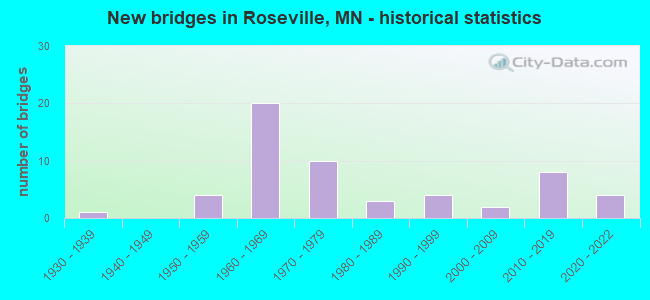
- New bridges - historical statistics
- 11930-1939
- 41950-1959
- 201960-1969
- 101970-1979
- 31980-1989
- 41990-1999
- 22000-2009
- 82010-2019
- 42020-2022
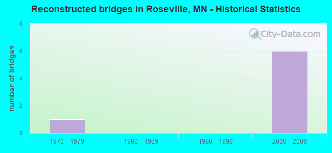
- Reconstructed bridges - Historical Statistics
- 11970-1979
- 01980-1989
- 01990-1999
- 62000-2009
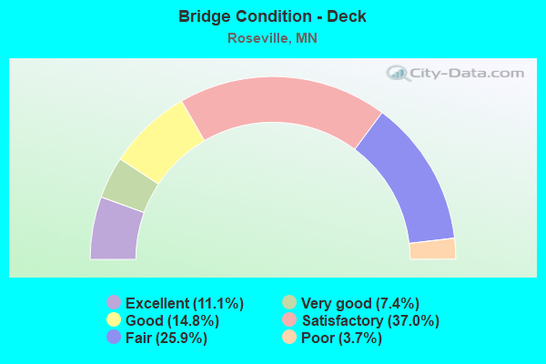
- Bridge Condition - Deck
- 11.1%Excellent
- 7.4%Very good
- 14.8%Good
- 37.0%Satisfactory
- 25.9%Fair
- 3.7%Poor
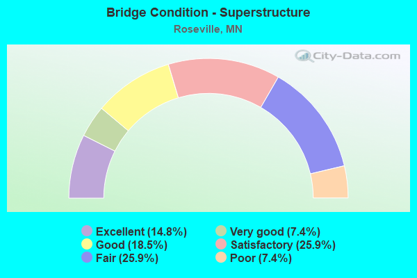
- Bridge Condition - Superstructure
- 14.8%Excellent
- 7.4%Very good
- 18.5%Good
- 25.9%Satisfactory
- 25.9%Fair
- 7.4%Poor
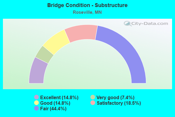
- Bridge Condition - Substructure
- 14.8%Excellent
- 7.4%Very good
- 14.8%Good
- 18.5%Satisfactory
- 44.4%Fair
Find on map >> Show street view
Structure Number: 9012, Location: 5.4 MI W OF E JCT TH 73 (Lat: 46.452386, Lng: -92.874742), Route carried "on" structure: State highway 27, Year Built: 2004, Status: Open, Structure Length: 4.42m (14.50ft), Average Daily Traffic: 585 (year 2019), Truck Traffic: 5%, Average Future Daily Traffic: 630 (year 2039), Design Load: HL 93, Features Intersected: KETTLE RIVER
Minimum Vertical Clearance: 30+ m (98+ ft), Kilometerpoint: 0.000, Lanes on structure: 2, Owner: State Highway Agency, Approaching Roadway Width: 11.0m (36.1ft), Material/Design: Prestressed concrete, Design/Construction: Stringer/Multi-beam, Number Of Spans In Main Unit: 1, Length of Maximum Span: 42.8m (140.4ft), Curb-To-Curb Width: 11.0m (36.1ft), Out-to-Out Width: 12.0m (39.4ft)
Condition: Deck: Good, Superstructure: Very good, Substructure: Very good, Channel: Very good, Operating Rating: 82.0 metric tons, Method Used To Determine Operating Rating: Load Factor (LF), Inventory Rating: 49.0 metric tons, Method Used To Determine Inventory Rating: Load Factor (LF), Structural Evaluation: Equal to present desirable criteria, Deck Geometry: Better than present minimum criteria, Waterway Adequacy: Superior to present desirable criteria, Approach Roadway Alignment: Equal to present desirable criteria, Length Of Structure Improvement: 1.62m (5.31ft), Designated Inspection Frequency: Every 24 months, Inspection Date: July 2020, Bridge Improvement Cost: $677,000,000, Roadway Improvement Cost: $1,000, Total Project Cost: $1,000, Deck Structure Type: Concrete Cast-file-Place, Wearing Surface/Protective System: Wearing Surface: Monolithic Concrete, Deck Protection: Epoxy Coated Reinforcing
Find on map >> Show street view
Structure Number: 9013, Location: 4.7 MI W OF E JCT TH 73 (Lat: 46.455258, Lng: -92.860114), Route carried "on" structure: State highway 27, Year Built: 2004, Status: Open, Structure Length: 1.43m (4.69ft), Average Daily Traffic: 2,117 (year 2019), Truck Traffic: 6%, Average Future Daily Traffic: 2,250 (year 2039), Design Load: HL 93, Features Intersected: GILLESPIE BROOK
Minimum Vertical Clearance: 30+ m (98+ ft), Kilometerpoint: 0.000, Lanes on structure: 2, Base Highway Network: Yes, Owner: State Highway Agency, Approaching Roadway Width: 12.2m (40.0ft), Skew: 3 degrees, Material/Design: Prestressed concrete, Design/Construction: Stringer/Multi-beam, Number Of Spans In Main Unit: 1, Length of Maximum Span: 13.4m (44.0ft), Curb-To-Curb Width: 13.4m (44.0ft), Out-to-Out Width: 14.4m (47.2ft)
Condition: Deck: Satisfactory, Superstructure: Very good, Substructure: Good, Channel: Very good, Operating Rating: 75.7 metric tons, Method Used To Determine Operating Rating: Load Factor (LF), Inventory Rating: 37.9 metric tons, Method Used To Determine Inventory Rating: Load Factor (LF), Structural Evaluation: Better than present minimum criteria, Deck Geometry: Better than present minimum criteria, Waterway Adequacy: Equal to present desirable criteria, Approach Roadway Alignment: Better than present minimum criteria, Length Of Structure Improvement: 0.61m (2.00ft), Designated Inspection Frequency: Every 24 months, Inspection Date: July 2020, Bridge Improvement Cost: $315,000,000, Roadway Improvement Cost: $1,000, Total Project Cost: $1,000, Deck Structure Type: Concrete Cast-file-Place, Wearing Surface/Protective System: Wearing Surface: Monolithic Concrete, Deck Protection: Epoxy Coated Reinforcing
Find on map >> Show street view
Structure Number: 62029, Location: 0.5 MI W OF JCT TH 51 WB (Lat: 45.010342, Lng: -93.176503), Route carried "on" structure: State highway 36, Year Built: 1969, Year Reconstructed: 2008, Status: Open, Structure Length: 6.14m (20.14ft), Average Daily Traffic: 44,000 (year 2017), Truck Traffic: 3%, Average Future Daily Traffic: 44,000 (year 2039), Design Load: HS 20, Features Intersected: Fairview Avenue
Minimum Vertical Clearance: 30+ m (98+ ft), Kilometerpoint: 0.000, Lanes on structure: 3, Lanes under structure: 6, Base Highway Network: Yes, Owner: State Highway Agency, Approaching Roadway Width: 15.5m (50.9ft), Material/Design: Prestressed concrete, Design/Construction: Stringer/Multi-beam, Number Of Spans In Main Unit: 3, Length of Maximum Span: 29.3m (96.1ft), Curb-To-Curb Width: 15.2m (49.9ft), Out-to-Out Width: 16.5m (54.1ft)
Condition: Deck: Fair, Superstructure: Good, Substructure: Fair, Operating Rating: 62.4 metric tons, Method Used To Determine Operating Rating: Load Factor (LF), Inventory Rating: 26.5 metric tons, Method Used To Determine Inventory Rating: Load Factor (LF), Structural Evaluation: Somewhat better than minimum adequacy, Deck Geometry: Meets minimum limits, Underclear: High priority of corrective action, Approach Roadway Alignment: Equal to present desirable criteria, Length Of Structure Improvement: 2.07m (6.79ft), Designated Inspection Frequency: Every 24 months, Inspection Date: August 2021, Bridge Improvement Cost: $999,999,000, Roadway Improvement Cost: $79,000,000, Total Project Cost: $999,999,000, Deck Structure Type: Concrete Cast-file-Place, Wearing Surface/Protective System: Wearing Surface: Low Slump Concrete
Find on map >> Show street view
Structure Number: 6203, Location: 0.5 MI W OF JCT TH 51 EB (Lat: 45.010028, Lng: -93.176400), Route carried "on" structure: State highway 36, Year Built: 1969, Year Reconstructed: 2008, Status: Open, Structure Length: 6.03m (19.78ft), Average Daily Traffic: 42,500 (year 2019), Truck Traffic: 2%, Average Future Daily Traffic: 44,000 (year 2039), Design Load: HS 20, Features Intersected: Fairview Avenue
Minimum Vertical Clearance: 30+ m (98+ ft), Kilometerpoint: 0.000, Lanes on structure: 4, Lanes under structure: 6, Base Highway Network: Yes, Owner: State Highway Agency, Approaching Roadway Width: 15.5m (50.9ft), Material/Design: Prestressed concrete, Design/Construction: Stringer/Multi-beam, Number Of Spans In Main Unit: 3, Length of Maximum Span: 29.5m (96.8ft), Curb-To-Curb Width: 16.3m (53.5ft), Out-to-Out Width: 17.6m (57.7ft)
Condition: Deck: Satisfactory, Superstructure: Satisfactory, Substructure: Fair, Operating Rating: 54.3 metric tons, Method Used To Determine Operating Rating: Load Factor (LF), Inventory Rating: 32.5 metric tons, Method Used To Determine Inventory Rating: Load Factor (LF), Structural Evaluation: Somewhat better than minimum adequacy, Deck Geometry: Meets minimum limits, Underclear: High priority of corrective action, Approach Roadway Alignment: Equal to present desirable criteria, Length Of Structure Improvement: 2.01m (6.59ft), Designated Inspection Frequency: Every 24 months, Inspection Date: August 2021, Bridge Improvement Cost: $999,999,000, Roadway Improvement Cost: $95,000,000, Total Project Cost: $999,999,000, Deck Structure Type: Concrete Cast-file-Place, Wearing Surface/Protective System: Wearing Surface: Low Slump Concrete
Find on map >> Show street view
Structure Number: 62035, Location: 0.5 MI E OF JCT TH 51 (Lat: 45.010292, Lng: -93.156700), Route carried "on" structure: County highway 50, Year Built: 1969, Status: Open, Structure Length: 5.11m (16.77ft), Average Daily Traffic: 12,000 (year 2015), Average Future Daily Traffic: 12,000 (year 2039), Design Load: HS 20, Features Intersected: TH 36
Minimum Vertical Clearance: 30+ m (98+ ft), Kilometerpoint: 0.000, Lanes on structure: 4, Lanes under structure: 6, Owner: State Highway Agency, Approaching Roadway Width: 14.6m (47.9ft), Material/Design: Prestressed concrete, Design/Construction: Stringer/Multi-beam, Number Of Spans In Main Unit: 2, Length of Maximum Span: 24.9m (81.7ft), Curb or Sidewalk Widths: Left: 1.8m (5.9ft), Right: 1.8m (5.9ft), Curb-To-Curb Width: 15.9m (52.2ft), Out-to-Out Width: 20.3m (66.6ft)
Condition: Deck: Satisfactory, Superstructure: Satisfactory, Substructure: Fair, Operating Rating: 75.7 metric tons, Method Used To Determine Operating Rating: Load Factor (LF), Inventory Rating: 29.6 metric tons, Method Used To Determine Inventory Rating: Load Factor (LF), Structural Evaluation: Somewhat better than minimum adequacy, Deck Geometry: Meets minimum limits, Underclear: Meets minimum limits, Approach Roadway Alignment: Equal to present desirable criteria, Designated Inspection Frequency: Every 24 months, Inspection Date: August 2021, Deck Structure Type: Concrete Cast-file-Place, Wearing Surface/Protective System: Wearing Surface: Low Slump Concrete
Find on map >> Show street view
Structure Number: 6204, Location: 0.2 MI N OF JCT TH 36 (Lat: 45.013456, Lng: -93.166978), Route carried "on" structure: State highway 51, Year Built: 1969, Status: Open, Structure Length: 6.37m (20.90ft), Average Daily Traffic: 46,000 (year 2019), Truck Traffic: 2%, Average Future Daily Traffic: 38,000 (year 2039), Design Load: HS 20, Features Intersected: CO RD B2 (CSAH 78)
Minimum Vertical Clearance: 30+ m (98+ ft), Kilometerpoint: 0.000, Lanes on structure: 6, Lanes under structure: 4, Owner: State Highway Agency, Approaching Roadway Width: 26.2m (86.0ft), Skew: 33 degrees, Material/Design: Prestressed concrete, Design/Construction: Stringer/Multi-beam, Number Of Spans In Main Unit: 3, Length of Maximum Span: 31.9m (104.7ft), Curb-To-Curb Width: 24.4m (80.1ft), Out-to-Out Width: 27.5m (90.2ft)
Condition: Deck: Fair, Superstructure: Fair, Substructure: Fair, Operating Rating: 43.3 metric tons, Method Used To Determine Operating Rating: Load Factor (LF), Inventory Rating: 30.0 metric tons, Method Used To Determine Inventory Rating: Load Factor (LF), Structural Evaluation: Somewhat better than minimum adequacy, Deck Geometry: Somewhat better than minimum adequacy, Underclear: Meets minimum limits, Approach Roadway Alignment: Equal to present desirable criteria, Length Of Structure Improvement: 2.13m (6.99ft), Designated Inspection Frequency: Every 24 months, Inspection Date: May 2020, Bridge Improvement Cost: $999,999,000, Total Project Cost: $999,999,000, Deck Structure Type: Concrete Cast-file-Place, Wearing Surface/Protective System: Wearing Surface: Low Slump Concrete
Find on map >> Show street view
Structure Number: 62069, Location: 1.5 MI E OF JCT TH 51 (Lat: 45.010161, Lng: -93.136081), Route carried "on" structure: County highway 52, Year Built: 1971, Status: Open, Structure Length: 8.73m (28.64ft), Average Daily Traffic: 3,750 (year 2015), Average Future Daily Traffic: 3,750 (year 2039), Design Load: HS 20, Features Intersected: TH 36
Minimum Vertical Clearance: 30+ m (98+ ft), Kilometerpoint: 0.000, Lanes on structure: 2, Lanes under structure: 4, Owner: State Highway Agency, Approaching Roadway Width: 14.6m (47.9ft), Skew: 1 degrees, Material/Design: Prestressed concrete, Design/Construction: Stringer/Multi-beam, Number Of Spans In Main Unit: 4, Length of Maximum Span: 29.7m (97.4ft), Curb or Sidewalk Widths: Left: 1.8m (5.9ft), Right: 0.0m, Curb-To-Curb Width: 13.4m (44.0ft), Out-to-Out Width: 16.3m (53.5ft)
Condition: Deck: Fair, Superstructure: Satisfactory, Substructure: Fair, Operating Rating: 99.6 metric tons, Method Used To Determine Operating Rating: Load Factor (LF), Inventory Rating: 44.1 metric tons, Method Used To Determine Inventory Rating: Load Factor (LF), Structural Evaluation: Somewhat better than minimum adequacy, Deck Geometry: Better than present minimum criteria, Underclear: Better than present minimum criteria, Approach Roadway Alignment: Better than present minimum criteria, Designated Inspection Frequency: Every 24 months, Inspection Date: August 2021, Deck Structure Type: Concrete Cast-file-Place, Wearing Surface/Protective System: Wearing Surface: Low Slump Concrete
Find on map >> Show street view
Structure Number: 62073, Location: 1.8 MI W OF JCT TH 35E (Lat: 45.009681, Lng: -93.126197), Route carried "on" structure: State highway 36, Year Built: 1999, Status: Open, Structure Length: 3.44m (11.29ft), Average Daily Traffic: 46,500 (year 2013), Truck Traffic: 3%, Average Future Daily Traffic: 46,500 (year 2039), Design Load: HS 25 or greater, Features Intersected: Dale St N CSAH 53
Minimum Vertical Clearance: 30+ m (98+ ft), Kilometerpoint: 0.000, Lanes on structure: 3, Lanes under structure: 4, Base Highway Network: Yes, Owner: State Highway Agency, Approaching Roadway Width: 11.9m (39.0ft), Material/Design: Prestressed concrete, Design/Construction: Stringer/Multi-beam, Number Of Spans In Main Unit: 1, Length of Maximum Span: 33.0m (108.3ft), Curb-To-Curb Width: 18.6m (61.0ft), Out-to-Out Width: 19.5m (64.0ft)
Condition: Deck: Good, Superstructure: Good, Substructure: Good, Operating Rating: 88.5 metric tons, Method Used To Determine Operating Rating: Load Factor (LF), Inventory Rating: 39.6 metric tons, Method Used To Determine Inventory Rating: Load Factor (LF), Structural Evaluation: Better than present minimum criteria, Deck Geometry: Superior to present desirable criteria, Approach Roadway Alignment: Equal to present desirable criteria, Designated Inspection Frequency: Every 24 months, Inspection Date: August 2021, Deck Structure Type: Concrete Cast-file-Place, Wearing Surface/Protective System: Wearing Surface: Low Slump Concrete, Deck Protection: Epoxy Coated Reinforcing
Find on map >> Show street view
Structure Number: 62074, Location: 1.8 MI W OF JCT TH 35E (Lat: 45.009514, Lng: -93.126206), Route carried "on" structure: State highway 36, Year Built: 1999, Status: Open, Structure Length: 3.44m (11.29ft), Average Daily Traffic: 44,000 (year 2019), Truck Traffic: 3%, Average Future Daily Traffic: 46,500 (year 2039), Design Load: HL 93, Features Intersected: Dale St N CSAH 53
Minimum Vertical Clearance: 30+ m (98+ ft), Kilometerpoint: 0.000, Lanes on structure: 3, Lanes under structure: 4, Base Highway Network: Yes, Owner: State Highway Agency, Approaching Roadway Width: 12.2m (40.0ft), Material/Design: Prestressed concrete, Design/Construction: Stringer/Multi-beam, Number Of Spans In Main Unit: 1, Length of Maximum Span: 33.0m (108.3ft), Curb-To-Curb Width: 18.6m (61.0ft), Out-to-Out Width: 19.5m (64.0ft)
Condition: Deck: Good, Superstructure: Good, Substructure: Good, Operating Rating: 78.4 metric tons, Method Used To Determine Operating Rating: Load Factor (LF), Inventory Rating: 34.9 metric tons, Method Used To Determine Inventory Rating: Load Factor (LF), Structural Evaluation: Better than present minimum criteria, Deck Geometry: Superior to present desirable criteria, Underclear: Somewhat better than minimum adequacy, Approach Roadway Alignment: Equal to present desirable criteria, Designated Inspection Frequency: Every 24 months, Inspection Date: August 2021, Deck Structure Type: Concrete Cast-file-Place, Wearing Surface/Protective System: Wearing Surface: Low Slump Concrete, Deck Protection: Epoxy Coated Reinforcing
Find on map >> Show street view
Structure Number: 62519, Location: 0.1 MI W OF JCT CSAH 52 (Lat: 45.019986, Lng: -93.140822), Route carried "on" structure: County highway 23, Year Built: 1970, Status: Posted for load, Structure Length: 6.86m (22.51ft), Average Daily Traffic: 10,900 (year 2016), Average Future Daily Traffic: 10,900 (year 2039), Design Load: HS 20, Features Intersected: BNSF RR
Minimum Vertical Clearance: 30+ m (98+ ft), Kilometerpoint: 0.000, Lanes on structure: 4, Owner: County Highway Agency, Approaching Roadway Width: 15.9m (52.2ft), Skew: 25 degrees, Material/Design: Prestressed concrete, Design/Construction: Stringer/Multi-beam, Number Of Spans In Main Unit: 3, Length of Maximum Span: 21.9m (71.9ft), Curb or Sidewalk Widths: Left: 1.5m (4.9ft), Right: 1.5m (4.9ft), Curb-To-Curb Width: 14.6m (47.9ft), Out-to-Out Width: 19.7m (64.6ft)
Condition: Deck: Poor, Superstructure: Fair, Substructure: Satisfactory, Operating Rating: 32.3 metric tons, Method Used To Determine Operating Rating: Load Factor (LF), Inventory Rating: 19.2 metric tons, Method Used To Determine Inventory Rating: Load Factor (LF), Structural Evaluation: Meets minimum limits, Deck Geometry: High priority of replacement, Underclear: High priority of corrective action, Approach Roadway Alignment: Somewhat better than minimum adequacy, Bridge Posting: Required (Relationship of Operating Rating to Maximum Legal Load: 0.1 - 9.9% below), Length Of Structure Improvement: 2.29m (7.51ft), Designated Inspection Frequency: Every 12 months, Inspection Date: November 2021, Bridge Improvement Cost: $999,999,000, Roadway Improvement Cost: $88,000,000, Total Project Cost: $999,999,000, Deck Structure Type: Concrete Cast-file-Place, Wearing Surface/Protective System: Wearing Surface: Monolithic Concrete
Find on map >> Show street view
Structure Number: 62548, Location: 0.3 MI N OF JCT TH 36 (Lat: 45.014722, Lng: -93.187561), Route carried "on" structure: County highway 24, Year Built: 1986, Status: Open, Structure Length: 26.05m (85.47ft), Average Daily Traffic: 5,900 (year 2016), Average Future Daily Traffic: 5,900 (year 2039), Design Load: HS 20, Features Intersected: I 35W; W FRONTAGE RD
Minimum Vertical Clearance: 30+ m (98+ ft), Kilometerpoint: 0.000, Lanes on structure: 4, Lanes under structure: 10, Owner: State Highway Agency, Approaching Roadway Width: 14.6m (47.9ft), Material/Design: Steel continuous, Design/Construction: Stringer/Multi-beam, Number Of Spans In Main Unit: 6, Length of Maximum Span: 48.8m (160.1ft), Curb or Sidewalk Widths: Left: 1.8m (5.9ft), Right: 0.0m, Curb-To-Curb Width: 15.9m (52.2ft), Out-to-Out Width: 18.5m (60.7ft)
Condition: Deck: Satisfactory, Superstructure: Satisfactory, Substructure: Fair, Operating Rating: 63.7 metric tons, Method Used To Determine Operating Rating: Load Factor (LF), Inventory Rating: 39.2 metric tons, Method Used To Determine Inventory Rating: Load Factor (LF), Structural Evaluation: Somewhat better than minimum adequacy, Deck Geometry: Meets minimum limits, Underclear: Somewhat better than minimum adequacy, Approach Roadway Alignment: Better than present minimum criteria, Designated Inspection Frequency: Every 24 months, Inspection Date: April 2020, Deck Structure Type: Concrete Cast-file-Place, Wearing Surface/Protective System: Wearing Surface: Low Slump Concrete, Deck Protection: Epoxy Coated Reinforcing
Find on map >> Show street view
Structure Number: 62731, Location: 1.0 MI E OF JCT TH 51 (Lat: 45.010472, Lng: -93.146500), Route carried "on" structure: State highway 36, Year Built: 2016, Status: Open, Structure Length: 2.87m (9.42ft), Average Daily Traffic: 88,000 (year 2019), Truck Traffic: 3%, Average Future Daily Traffic: 93,000 (year 2039), Design Load: HL 93, Features Intersected: LEXINGTON AVE(CSAH 51)
Minimum Vertical Clearance: 30+ m (98+ ft), Kilometerpoint: 0.000, Lanes on structure: 2, Lanes under structure: 2, Base Highway Network: Yes, Owner: State Highway Agency, Approaching Roadway Width: 12.8m (42.0ft), Material/Design: Prestressed concrete, Design/Construction: Stringer/Multi-beam, Number Of Spans In Main Unit: 1, Length of Maximum Span: 27.3m (89.6ft), Curb-To-Curb Width: 12.8m (42.0ft), Out-to-Out Width: 13.8m (45.3ft)
Condition: Deck: Good, Superstructure: Good, Substructure: Very good, Operating Rating: 56.4 metric tons, Method Used To Determine Operating Rating: Load and Resistance Factor Rating (LRFR) rating reported by rating factor(RF) method using HL-93 loadings, Inventory Rating: 36.9 metric tons, Method Used To Determine Inventory Rating: Load and Resistance Factor Rating (LRFR) rating reported by rating factor(RF) method using HL-93 loadings, Structural Evaluation: Better than present minimum criteria, Deck Geometry: Somewhat better than minimum adequacy, Underclear: Equal to present minimum criteria, Approach Roadway Alignment: Equal to present desirable criteria, Designated Inspection Frequency: Every 24 months, Inspection Date: May 2020, Deck Structure Type: Concrete Cast-file-Place, Wearing Surface/Protective System: Wearing Surface: Monolithic Concrete, Deck Protection: Epoxy Coated Reinforcing
Find on map >> Show street view
Structure Number: 62734, Location: 1.0 Mi East of Jct TH 51 (Lat: 45.010472, Lng: -93.146500), Route carried "on" structure: State highway 36, Year Built: 2016, Status: Open, Structure Length: 2.87m (9.42ft), Average Daily Traffic: 88,000 (year 2019), Truck Traffic: 3%, Average Future Daily Traffic: 93,000 (year 2039), Design Load: HL 93, Features Intersected: LEXINGTON AVE(CSAH 51)
Minimum Vertical Clearance: 30+ m (98+ ft), Kilometerpoint: 0.000, Lanes on structure: 2, Lanes under structure: 2, Base Highway Network: Yes, Owner: State Highway Agency, Approaching Roadway Width: 18.1m (59.4ft), Material/Design: Prestressed concrete, Design/Construction: Stringer/Multi-beam, Number Of Spans In Main Unit: 1, Length of Maximum Span: 27.3m (89.6ft), Curb-To-Curb Width: 18.1m (59.4ft), Out-to-Out Width: 19.1m (62.7ft)
Condition: Deck: Very good, Superstructure: Good, Substructure: Good, Operating Rating: 58.0 metric tons, Method Used To Determine Operating Rating: Load and Resistance Factor Rating (LRFR) rating reported by rating factor(RF) method using HL-93 loadings, Inventory Rating: 38.9 metric tons, Method Used To Determine Inventory Rating: Load and Resistance Factor Rating (LRFR) rating reported by rating factor(RF) method using HL-93 loadings, Structural Evaluation: Better than present minimum criteria, Deck Geometry: Superior to present desirable criteria, Underclear: Equal to present desirable criteria, Approach Roadway Alignment: Equal to present desirable criteria, Designated Inspection Frequency: Every 24 months, Inspection Date: May 2020, Deck Structure Type: Concrete Cast-file-Place, Wearing Surface/Protective System: Wearing Surface: Monolithic Concrete, Deck Protection: Epoxy Coated Reinforcing
Find on map >> Show street view
Structure Number: 62821, Location: AT JCT TH 35W; 280 (Lat: 45.010219, Lng: -93.202492), Route carried "on" structure: Ramp State highway 856, Year Built: 1970, Status: Open, Structure Length: 6.07m (19.91ft), Average Daily Traffic: 2,325 (year 2003), Average Future Daily Traffic: 2,325 (year 2029), Design Load: HS 20, Features Intersected: TH 280 SB
Minimum Vertical Clearance: 30+ m (98+ ft), Kilometerpoint: 0.000, Lanes on structure: 1, Lanes under structure: 2, Base Highway Network: Yes, Owner: State Highway Agency, Approaching Roadway Width: 7.3m (24.0ft), Skew: 4 degrees, Material/Design: Prestressed concrete, Design/Construction: Stringer/Multi-beam, Number Of Spans In Main Unit: 3, Length of Maximum Span: 23.8m (78.1ft), Curb-To-Curb Width: 7.9m (25.9ft), Out-to-Out Width: 9.2m (30.2ft)
Condition: Deck: Satisfactory, Superstructure: Satisfactory, Substructure: Fair, Operating Rating: 64.9 metric tons, Method Used To Determine Operating Rating: Load Factor (LF), Inventory Rating: 32.2 metric tons, Method Used To Determine Inventory Rating: Load Factor (LF), Structural Evaluation: Somewhat better than minimum adequacy, Deck Geometry: Equal to present desirable criteria, Underclear: Equal to present minimum criteria, Approach Roadway Alignment: Equal to present desirable criteria, Designated Inspection Frequency: Every 24 months, Inspection Date: June 2020, Deck Structure Type: Concrete Cast-file-Place, Wearing Surface/Protective System: Wearing Surface: Low Slump Concrete
Find on map >> Show street view
Structure Number: 62853, Location: AT JCT TH 280; 35W (Lat: 45.009044, Lng: -93.202117), Route carried "on" structure: Ramp Interstate 3490, Year Built: 1970, Status: Open, Structure Length: 8.97m (29.43ft), Average Daily Traffic: 10,000 (year 1994), Average Future Daily Traffic: 10,000 (year 2029), Design Load: HS 20+Mod, Features Intersected: TH 280 NB
Minimum Vertical Clearance: 30+ m (98+ ft), Kilometerpoint: 0.000, Lanes on structure: 2, Lanes under structure: 1, Base Highway Network: Yes, Owner: State Highway Agency, Approaching Roadway Width: 11.3m (37.1ft), Material/Design: Steel continuous, Design/Construction: Stringer/Multi-beam, Number Of Spans In Main Unit: 3, Length of Maximum Span: 34.9m (114.5ft), Curb-To-Curb Width: 12.0m (39.4ft), Out-to-Out Width: 13.2m (43.3ft)
Condition: Deck: Satisfactory, Superstructure: Satisfactory, Substructure: Satisfactory, Operating Rating: 60.4 metric tons, Method Used To Determine Operating Rating: Load Factor (LF), Inventory Rating: 36.3 metric tons, Method Used To Determine Inventory Rating: Load Factor (LF), Structural Evaluation: Equal to present minimum criteria, Deck Geometry: Superior to present desirable criteria, Underclear: Meets minimum limits, Approach Roadway Alignment: Equal to present desirable criteria, Length Of Structure Improvement: 3.02m (9.91ft), Designated Inspection Frequency: Every 12 months, Critical Feature Inspection Frequency: Every 24 months, Inspection Date: May 2021, Critical Feature Inspection Date: May 2021, Bridge Improvement Cost: $999,999,000, Roadway Improvement Cost: $77,000,000, Total Project Cost: $999,999,000, Deck Structure Type: Concrete Cast-file-Place, Wearing Surface/Protective System: Wearing Surface: Low Slump Concrete
Find on map >> Show street view
Structure Number: 6286, Location: AT JCT TH 280; 35W (Lat: 45.007858, Lng: -93.204528), Route carried "on" structure: Interstate 35W, Year Built: 1970, Status: Open, Structure Length: 6.40m (21.00ft), Average Daily Traffic: 103,000 (year 2019), Truck Traffic: 4%, Average Future Daily Traffic: 116,000 (year 2039), Design Load: HS 20+Mod, Features Intersected: NB RAMP; TH280 SB
Minimum Vertical Clearance: 30+ m (98+ ft), Kilometerpoint: 0.000, Lanes on structure: 7, Lanes under structure: 4, Base Highway Network: Yes, Owner: State Highway Agency, Approaching Roadway Width: 39.6m (129.9ft), Skew: 34 degrees, Material/Design: Prestressed concrete, Design/Construction: Stringer/Multi-beam, Number Of Spans In Main Unit: 2, Length of Maximum Span: 30.9m (101.4ft), Curb-To-Curb Width: 38.2m (125.3ft), Out-to-Out Width: 40.9m (134.2ft)
Condition: Deck: Satisfactory, Superstructure: Satisfactory, Substructure: Satisfactory, Operating Rating: 77.4 metric tons, Method Used To Determine Operating Rating: Load Factor (LF), Inventory Rating: 22.5 metric tons, Method Used To Determine Inventory Rating: Load Factor (LF), Structural Evaluation: Somewhat better than minimum adequacy, Deck Geometry: Superior to present desirable criteria, Underclear: Equal to present minimum criteria, Approach Roadway Alignment: Equal to present desirable criteria, Length Of Structure Improvement: 2.13m (6.99ft), Designated Inspection Frequency: Every 24 months, Inspection Date: April 2020, Bridge Improvement Cost: $999,999,000, Deck Structure Type: Concrete Cast-file-Place, Wearing Surface/Protective System: Wearing Surface: Low Slump Concrete
Find on map >> Show street view
Structure Number: 62938, Location: 0.7 MI N OF JCT MN 36 (Lat: 45.019642, Lng: -93.188806), Route carried "on" structure: Interstate 35W, Year Built: 2021, Status: Open, Structure Length: 4.98m (16.34ft), Average Daily Traffic: 46,000 (year 2019), Truck Traffic: 5%, Average Future Daily Traffic: 76,750 (year 2039), Design Load: HL 93, Features Intersected: ROSEGATE;RAILROAD
Minimum Vertical Clearance: 30+ m (98+ ft), Kilometerpoint: 0.000, Lanes on structure: 5, Lanes under structure: 2, Base Highway Network: Yes, Owner: State Highway Agency, Approaching Roadway Width: 20.0m (65.6ft), Material/Design: Prestressed concrete, Design/Construction: Stringer/Multi-beam, Number Of Spans In Main Unit: 2, Number Of Approach Spans: 2, Length of Maximum Span: 26.4m (86.6ft), Curb-To-Curb Width: 22.3m (73.2ft), Out-to-Out Width: 23.1m (75.8ft)
Condition: Deck: Excellent, Superstructure: Excellent, Substructure: Excellent, Operating Rating: 47.3 metric tons, Method Used To Determine Operating Rating: Load and Resistance Factor Rating (LRFR) rating reported by rating factor(RF) method using HL-93 loadings, Inventory Rating: 36.3 metric tons, Method Used To Determine Inventory Rating: Load and Resistance Factor Rating (LRFR) rating reported by rating factor(RF) method using HL-93 loadings, Structural Evaluation: Superior to present desirable criteria, Deck Geometry: Meets minimum limits, Underclear: High priority of corrective action, Approach Roadway Alignment: Equal to present desirable criteria, Designated Inspection Frequency: Every 24 months, Inspection Date: August 2021, Deck Structure Type: Concrete Cast-file-Place, Wearing Surface/Protective System: Wearing Surface: Low Slump Concrete, Deck Protection: Epoxy Coated Reinforcing
Find on map >> Show street view
Structure Number: 62939, Location: 0.7 MI N OF JCT TH 36 (Lat: 45.019567, Lng: -93.189111), Route carried "on" structure: Interstate 35W, Year Built: 2019, Status: Open, Structure Length: 4.98m (16.34ft), Average Daily Traffic: 52,000 (year 2018), Truck Traffic: 6%, Average Future Daily Traffic: 76,750 (year 2040), Design Load: HL 93, Features Intersected: ROSEGATE; BNSR RR
Minimum Vertical Clearance: 30+ m (98+ ft), Kilometerpoint: 0.000, Lanes on structure: 5, Lanes under structure: 2, Base Highway Network: Yes, Owner: State Highway Agency, Approaching Roadway Width: 21.5m (70.5ft), Material/Design: Prestressed concrete, Design/Construction: Stringer/Multi-beam, Number Of Spans In Main Unit: 2, Length of Maximum Span: 27.3m (89.6ft), Curb-To-Curb Width: 21.5m (70.5ft), Out-to-Out Width: 22.3m (73.2ft)
Condition: Deck: Excellent, Superstructure: Excellent, Substructure: Excellent, Operating Rating: 45.7 metric tons, Method Used To Determine Operating Rating: Load and Resistance Factor Rating (LRFR) rating reported by rating factor(RF) method using HL-93 loadings, Inventory Rating: 35.3 metric tons, Method Used To Determine Inventory Rating: Load and Resistance Factor Rating (LRFR) rating reported by rating factor(RF) method using HL-93 loadings, Structural Evaluation: Superior to present desirable criteria, Deck Geometry: Meets minimum limits, Underclear: High priority of corrective action, Approach Roadway Alignment: Equal to present desirable criteria, Designated Inspection Frequency: Every 24 months, Inspection Date: August 2021, Deck Structure Type: Concrete Cast-file-Place, Wearing Surface/Protective System: Wearing Surface: Monolithic Concrete, Deck Protection: Epoxy Coated Reinforcing
Find on map >> Show street view
Structure Number: 6294, Location: 5.5 MI W OF JCT TH 73 (Lat: 46.671422, Lng: -92.998161), Route carried "on" structure: State highway 210, Year Built: 1930, Status: Open, Structure Length: 0.70m (2.30ft), Average Daily Traffic: 2,152 (year 2019), Truck Traffic: 14%, Average Future Daily Traffic: 2,500 (year 2039), Design Load: H 15, Features Intersected: TAMARACK RIVER
Minimum Vertical Clearance: 30+ m (98+ ft), Kilometerpoint: 0.000, Lanes on structure: 2, Base Highway Network: Yes, Owner: State Highway Agency, Approaching Roadway Width: 12.2m (40.0ft), Material/Design: Concrete, Design/Construction: Culvert, Number Of Spans In Main Unit: 2, Length of Maximum Span: 3.0m (9.8ft)
Condition: Channel: Very good, Culverts: Poor, Operating Rating: 39.2 metric tons, Method Used To Determine Operating Rating: Assigned ratings based on Allowable Stress Design (ASD) reported in metric tons, Inventory Rating: 29.4 metric tons, Method Used To Determine Inventory Rating: Assigned ratings based on Allowable Stress Design (ASD) reported in metric tons, Structural Evaluation: Meets minimum limits, Waterway Adequacy: Equal to present desirable criteria, Approach Roadway Alignment: Equal to present desirable criteria, Length Of Structure Improvement: 0.34m (1.12ft), Designated Inspection Frequency: Every 12 months, Inspection Date: August 2021, Bridge Improvement Cost: $81,000,000, Roadway Improvement Cost: $3,000,000, Total Project Cost: $48,000,000
Find on map >> Show street view
Structure Number: 6294, Location: 0.8 MI N OF JCT MN 36 (Lat: 45.020578, Lng: -93.189142), Route carried "on" structure: Interstate 35W, Year Built: 2021, Status: Open, Structure Length: 5.41m (17.75ft), Average Daily Traffic: 46,000 (year 2019), Truck Traffic: 5%, Average Future Daily Traffic: 39,000 (year 2039), Design Load: HL 93, Features Intersected: COUNTY RD C
Minimum Vertical Clearance: 30+ m (98+ ft), Kilometerpoint: 0.000, Lanes on structure: 5, Lanes under structure: 5, Base Highway Network: Yes, Owner: State Highway Agency, Approaching Roadway Width: 19.4m (63.6ft), Skew: 1 degrees, Material/Design: Prestressed concrete, Design/Construction: Stringer/Multi-beam, Number Of Spans In Main Unit: 1, Length of Maximum Span: 53.0m (173.9ft), Curb-To-Curb Width: 22.3m (73.2ft), Out-to-Out Width: 23.1m (75.8ft)
Condition: Deck: Very good, Superstructure: Excellent, Substructure: Excellent, Operating Rating: 81.3 metric tons, Method Used To Determine Operating Rating: Load and Resistance Factor Rating (LRFR) rating reported by rating factor(RF) method using HL-93 loadings, Inventory Rating: 43.7 metric tons, Method Used To Determine Inventory Rating: Load and Resistance Factor Rating (LRFR) rating reported by rating factor(RF) method using HL-93 loadings, Structural Evaluation: Superior to present desirable criteria, Deck Geometry: Meets minimum limits, Underclear: Meets minimum limits, Approach Roadway Alignment: Equal to present desirable criteria, Designated Inspection Frequency: Every 24 months, Inspection Date: August 2021, Deck Structure Type: Concrete Cast-file-Place, Wearing Surface/Protective System: Wearing Surface: Low Slump Concrete, Deck Protection: Epoxy Coated Reinforcing
Find on map >> Show street view
Structure Number: 62941, Location: 0.8 MI N OF JCT TH 36 (Lat: 45.020567, Lng: -93.189483), Route carried "on" structure: Interstate 35W, Year Built: 2019, Status: Open, Structure Length: 5.41m (17.75ft), Average Daily Traffic: 52,000 (year 2018), Truck Traffic: 6%, Average Future Daily Traffic: 52,000 (year 2039), Design Load: HL 93, Features Intersected: CSAH 23
Minimum Vertical Clearance: 30+ m (98+ ft), Kilometerpoint: 0.000, Lanes on structure: 5, Lanes under structure: 5, Base Highway Network: Yes, Owner: State Highway Agency, Approaching Roadway Width: 18.7m (61.4ft), Skew: 1 degrees, Material/Design: Prestressed concrete, Design/Construction: Stringer/Multi-beam, Number Of Spans In Main Unit: 1, Length of Maximum Span: 53.0m (173.9ft), Curb-To-Curb Width: 21.5m (70.5ft), Out-to-Out Width: 22.3m (73.2ft)
Condition: Deck: Excellent, Superstructure: Excellent, Substructure: Excellent, Operating Rating: 61.9 metric tons, Method Used To Determine Operating Rating: Load and Resistance Factor Rating (LRFR) rating reported by rating factor(RF) method using HL-93 loadings, Inventory Rating: 34.7 metric tons, Method Used To Determine Inventory Rating: Load and Resistance Factor Rating (LRFR) rating reported by rating factor(RF) method using HL-93 loadings, Structural Evaluation: Superior to present desirable criteria, Deck Geometry: Meets minimum limits, Underclear: Meets minimum limits, Approach Roadway Alignment: Equal to present desirable criteria, Designated Inspection Frequency: Every 24 months, Inspection Date: August 2021, Deck Structure Type: Concrete Cast-file-Place, Wearing Surface/Protective System: Wearing Surface: Monolithic Concrete, Deck Protection: Epoxy Coated Reinforcing
Find on map >> Show street view
Structure Number: 9012, Location: AT THE JCT TH 36; 51 SB (Lat: 45.010250, Lng: -93.166633), Route carried "on" structure: State highway 51, Year Built: 1958, Status: Open, Structure Length: 7.01m (23.00ft), Average Daily Traffic: 15,750 (year 2017), Truck Traffic: 2%, Average Future Daily Traffic: 15,750 (year 2039), Design Load: HS 20, Features Intersected: TH 36
Minimum Vertical Clearance: 30+ m (98+ ft), Kilometerpoint: 0.000, Lanes on structure: 3, Lanes under structure: 4, Owner: State Highway Agency, Approaching Roadway Width: 13.4m (44.0ft), Material/Design: Steel continuous, Design/Construction: Stringer/Multi-beam, Number Of Spans In Main Unit: 4, Length of Maximum Span: 24.1m (79.1ft), Curb-To-Curb Width: 13.7m (44.9ft), Out-to-Out Width: 14.7m (48.2ft)
Condition: Deck: Fair, Superstructure: Fair, Substructure: Fair, Operating Rating: 46.7 metric tons, Method Used To Determine Operating Rating: Load Factor (LF), Inventory Rating: 27.9 metric tons, Method Used To Determine Inventory Rating: Load Factor (LF), Structural Evaluation: Somewhat better than minimum adequacy, Deck Geometry: Somewhat better than minimum adequacy, Underclear: High priority of corrective action, Approach Roadway Alignment: Equal to present desirable criteria, Length Of Structure Improvement: 2.35m (7.71ft), Designated Inspection Frequency: Every 24 months, Inspection Date: May 2020, Bridge Improvement Cost: $999,999,000, Roadway Improvement Cost: $4,000,000, Total Project Cost: $67,000,000, Deck Structure Type: Concrete Cast-file-Place, Wearing Surface/Protective System: Wearing Surface: Low Slump Concrete, Deck Protection: Epoxy Coated Reinforcing
Find on map >> Show street view
Structure Number: 9013, Location: AT THE JCT TH36; 51NB (Lat: 45.010161, Lng: -93.166381), Route carried "on" structure: State highway 51, Year Built: 1958, Status: Open, Structure Length: 7.01m (23.00ft), Average Daily Traffic: 15,685 (year 2019), Truck Traffic: 3%, Average Future Daily Traffic: 15,750 (year 2039), Design Load: HS 20, Features Intersected: TH 36
Minimum Vertical Clearance: 30+ m (98+ ft), Kilometerpoint: 0.000, Lanes on structure: 3, Lanes under structure: 4, Owner: State Highway Agency, Approaching Roadway Width: 13.4m (44.0ft), Material/Design: Steel continuous, Design/Construction: Stringer/Multi-beam, Number Of Spans In Main Unit: 4, Length of Maximum Span: 24.1m (79.1ft), Curb-To-Curb Width: 13.7m (44.9ft), Out-to-Out Width: 14.7m (48.2ft)
Condition: Deck: Fair, Superstructure: Fair, Substructure: Fair, Operating Rating: 46.7 metric tons, Method Used To Determine Operating Rating: Load Factor (LF), Inventory Rating: 27.9 metric tons, Method Used To Determine Inventory Rating: Load Factor (LF), Structural Evaluation: Somewhat better than minimum adequacy, Deck Geometry: Somewhat better than minimum adequacy, Underclear: Meets minimum limits, Approach Roadway Alignment: Equal to present desirable criteria, Designated Inspection Frequency: Every 24 months, Inspection Date: May 2020, Deck Structure Type: Concrete Cast-file-Place, Wearing Surface/Protective System: Wearing Surface: Low Slump Concrete, Deck Protection: Epoxy Coated Reinforcing
Find on map >> Show street view
Structure Number: 9276, Location: 0.2 MI E OF JCT TH 35W (Lat: 45.010317, Lng: -93.186700), Route carried "on" structure: State highway 36, Year Built: 1963, Year Reconstructed: 2008, Status: Open, Structure Length: 5.06m (16.60ft), Average Daily Traffic: 44,000 (year 2017), Truck Traffic: 3%, Average Future Daily Traffic: 44,000 (year 2039), Design Load: HS 20+Mod, Features Intersected: Cleveland Avenue
Minimum Vertical Clearance: 30+ m (98+ ft), Kilometerpoint: 0.000, Lanes on structure: 3, Lanes under structure: 4, Base Highway Network: Yes, Owner: State Highway Agency, Approaching Roadway Width: 11.3m (37.1ft), Material/Design: Steel continuous, Design/Construction: Stringer/Multi-beam, Number Of Spans In Main Unit: 2, Length of Maximum Span: 25.0m (82.0ft), Curb-To-Curb Width: 11.9m (39.0ft), Out-to-Out Width: 13.6m (44.6ft)
Condition: Deck: Fair, Superstructure: Fair, Substructure: Fair, Operating Rating: 72.7 metric tons, Method Used To Determine Operating Rating: Load Factor (LF), Inventory Rating: 43.6 metric tons, Method Used To Determine Inventory Rating: Load Factor (LF), Structural Evaluation: Somewhat better than minimum adequacy, Deck Geometry: High priority of replacement, Underclear: Meets minimum limits, Approach Roadway Alignment: Equal to present desirable criteria, Length Of Structure Improvement: 1.71m (5.61ft), Designated Inspection Frequency: Every 24 months, Inspection Date: August 2021, Bridge Improvement Cost: $999,999,000, Roadway Improvement Cost: $22,000,000, Total Project Cost: $339,000,000, Deck Structure Type: Concrete Cast-file-Place, Wearing Surface/Protective System: Wearing Surface: Low Slump Concrete, Deck Protection: Other
Find on map >> Show street view
Structure Number: 9277, Location: 0.2 MI E OF JCT TH 35W (Lat: 45.010039, Lng: -93.186731), Route carried "on" structure: State highway 36, Year Built: 1963, Year Reconstructed: 2008, Status: Open, Structure Length: 5.06m (16.60ft), Average Daily Traffic: 42,500 (year 2019), Truck Traffic: 2%, Average Future Daily Traffic: 44,000 (year 2039), Design Load: HS 20+Mod, Features Intersected: Cleveland Avenue
Minimum Vertical Clearance: 30+ m (98+ ft), Kilometerpoint: 0.000, Lanes on structure: 4, Lanes under structure: 4, Base Highway Network: Yes, Owner: State Highway Agency, Approaching Roadway Width: 17.1m (56.1ft), Material/Design: Steel continuous, Design/Construction: Stringer/Multi-beam, Number Of Spans In Main Unit: 2, Length of Maximum Span: 25.0m (82.0ft), Curb-To-Curb Width: 18.1m (59.4ft), Out-to-Out Width: 19.5m (64.0ft)
Condition: Deck: Satisfactory, Superstructure: Fair, Substructure: Fair, Operating Rating: 68.8 metric tons, Method Used To Determine Operating Rating: Load Factor (LF), Inventory Rating: 41.3 metric tons, Method Used To Determine Inventory Rating: Load Factor (LF), Structural Evaluation: Somewhat better than minimum adequacy, Deck Geometry: Meets minimum limits, Underclear: Meets minimum limits, Approach Roadway Alignment: Equal to present desirable criteria, Designated Inspection Frequency: Every 24 months, Inspection Date: August 2021, Deck Structure Type: Concrete Cast-file-Place, Wearing Surface/Protective System: Wearing Surface: Low Slump Concrete
Find on map >> Show street view
Structure Number: 9355, Location: 1.5 MI N OF JCT TH 36 (Lat: 45.035631, Lng: -93.190497), Route carried "on" structure: County highway 19, Year Built: 1963, Year Reconstructed: 1984, Status: Open, Structure Length: 7.08m (23.23ft), Average Daily Traffic: 15,200 (year 2016), Average Future Daily Traffic: 15,200 (year 2039), Design Load: HS 20, Features Intersected: I 35W
Minimum Vertical Clearance: 30+ m (98+ ft), Kilometerpoint: 0.000, Lanes on structure: 4, Lanes under structure: 6, Owner: State Highway Agency, Approaching Roadway Width: 15.9m (52.2ft), Skew: 1 degrees, Material/Design: Steel continuous, Design/Construction: Stringer/Multi-beam, Number Of Spans In Main Unit: 4, Length of Maximum Span: 24.8m (81.4ft), Curb or Sidewalk Widths: Left: 2.4m (7.9ft), Right: 1.8m (5.9ft), Curb-To-Curb Width: 15.9m (52.2ft), Out-to-Out Width: 20.8m (68.2ft)
Condition: Deck: Satisfactory, Superstructure: Fair, Substructure: Satisfactory, Operating Rating: 82.4 metric tons, Method Used To Determine Operating Rating: Load Factor (LF), Inventory Rating: 49.3 metric tons, Method Used To Determine Inventory Rating: Load Factor (LF), Structural Evaluation: Somewhat better than minimum adequacy, Deck Geometry: Meets minimum limits, Underclear: Meets minimum limits, Approach Roadway Alignment: Equal to present desirable criteria, Designated Inspection Frequency: Every 24 months, Inspection Date: April 2020, Deck Structure Type: Concrete Cast-file-Place, Wearing Surface/Protective System: Wearing Surface: Low Slump Concrete, Deck Protection: Epoxy Coated Reinforcing
Find on map >> Show street view
Structure Number: 9569, Location: AT JCT TH 36 35W (Lat: 45.010439, Lng: -93.190244), Route carried "on" structure: State highway 36, Year Built: 1964, Year Reconstructed: 2008, Status: Open, Structure Length: 16.70m (54.79ft), Average Daily Traffic: 42,500 (year 2019), Truck Traffic: 3%, Average Future Daily Traffic: 44,000 (year 2039), Design Load: HS 20+Mod, Features Intersected: I 35W
Minimum Vertical Clearance: 30+ m (98+ ft), Kilometerpoint: 0.000, Lanes on structure: 2, Lanes under structure: 6, Base Highway Network: Yes, Owner: State Highway Agency, Approaching Roadway Width: 11.3m (37.1ft), Material/Design: Concrete continuous, Design/Construction: Box Beam or Girders - Multiple, Number Of Spans In Main Unit: 5, Length of Maximum Span: 42.1m (138.1ft), Curb-To-Curb Width: 9.7m (31.8ft), Out-to-Out Width: 10.8m (35.4ft)
Condition: Deck: Fair, Superstructure: Poor, Substructure: Fair, Operating Rating: 99.6 metric tons, Method Used To Determine Operating Rating: Load Factor (LF), Inventory Rating: 60.8 metric tons, Method Used To Determine Inventory Rating: Load Factor (LF), Structural Evaluation: Meets minimum limits, Deck Geometry: Meets minimum limits, Underclear: High priority of corrective action, Approach Roadway Alignment: Equal to present minimum criteria, Length Of Structure Improvement: 5.09m (16.70ft), Designated Inspection Frequency: Every 12 months, Inspection Date: August 2021, Bridge Improvement Cost: $999,999,000, Roadway Improvement Cost: $145,000,000, Total Project Cost: $999,999,000, Deck Structure Type: Concrete Cast-file-Place, Wearing Surface/Protective System: Wearing Surface: Low Slump Concrete
Find on map >> Show street view
Structure Number: 9588, Location: 0.1 MI NE OF JCT TH 36 (Lat: 45.012856, Lng: -93.187278), Route carried "on" structure: Ramp Interstate 1424, Year Built: 1964, Year Reconstructed: 2008, Status: Open, Structure Length: 11.22m (36.81ft), Average Daily Traffic: 7,250 (year 1996), Average Future Daily Traffic: 7,250 (year 2029), Design Load: HS 20, Features Intersected: I 35W NB
Minimum Vertical Clearance: 30+ m (98+ ft), Kilometerpoint: 0.000, Lanes on structure: 2, Lanes under structure: 3, Base Highway Network: Yes, Owner: State Highway Agency, Approaching Roadway Width: 11.0m (36.1ft), Material/Design: Concrete continuous, Design/Construction: Box Beam or Girders - Multiple, Number Of Spans In Main Unit: 4, Length of Maximum Span: 40.2m (131.9ft), Curb-To-Curb Width: 9.1m (29.9ft), Out-to-Out Width: 10.8m (35.4ft)
Condition: Deck: Satisfactory, Superstructure: Poor, Substructure: Satisfactory, Operating Rating: 87.2 metric tons, Method Used To Determine Operating Rating: Load Factor (LF), Inventory Rating: 52.4 metric tons, Method Used To Determine Inventory Rating: Load Factor (LF), Structural Evaluation: Meets minimum limits, Deck Geometry: Meets minimum limits, Underclear: Meets minimum limits, Approach Roadway Alignment: Equal to present desirable criteria, Designated Inspection Frequency: Every 24 months, Inspection Date: April 2020, Deck Structure Type: Concrete Cast-file-Place, Wearing Surface/Protective System: Wearing Surface: Low Slump Concrete
Find on map >> Show street view
Structure Number: 62029, Location: 0.5 MI W OF JCT TH 51 WB (Lat: 45.010342, Lng: -93.176503), Route carried "under" structure: County highway 48, Year Built: 1969, Structure Length: 0. m, Average Daily Traffic: 34,000 (year 2005), Features Intersected: Fairview Avenue, Facility Carried by Structure: MN 36
Minimum Vertical Clearance: 5.76m (18.90ft), Kilometerpoint: 0.000, Lanes on structure: 3, Lanes under structure: 6, Material/Design: Prestressed concrete, Design/Construction: Stringer/Multi-beam, Length of Maximum Span: 29.3m (96.1ft)
Find on map >> Show street view
Structure Number: 6203, Location: 0.5 MI W OF JCT TH 51 EB (Lat: 45.010028, Lng: -93.176400), Route carried "under" structure: County highway 48, Year Built: 1969, Structure Length: 0. m, Average Daily Traffic: 34,000 (year 2005), Features Intersected: Fairview Avenue, Facility Carried by Structure: MN 36
Minimum Vertical Clearance: 4.97m (16.31ft), Kilometerpoint: 0.000, Lanes on structure: 4, Lanes under structure: 6, Material/Design: Prestressed concrete, Design/Construction: Stringer/Multi-beam, Length of Maximum Span: 29.5m (96.8ft)
Find on map >> Show street view
Structure Number: 62035, Location: 0.5 MI E OF JCT TH 51 (Lat: 45.010292, Lng: -93.156700), Route carried "under" structure: State highway 36, Year Built: 1969, Structure Length: 0. m, Average Daily Traffic: 87,000 (year 2019), Truck Traffic: 3%, Features Intersected: TH 36, Facility Carried by Structure: CSAH 50
Minimum Vertical Clearance: 4.91m (16.11ft), Kilometerpoint: 0.000, Lanes on structure: 4, Lanes under structure: 6, Material/Design: Prestressed concrete, Design/Construction: Stringer/Multi-beam, Length of Maximum Span: 24.9m (81.7ft)
Find on map >> Show street view
Structure Number: 6204, Location: 0.2 MI N OF JCT TH 36 (Lat: 45.013456, Lng: -93.166978), Route carried "under" structure: County highway 78, Year Built: 1969, Structure Length: 0. m, Average Daily Traffic: 18,100 (year 2005), Features Intersected: CO RD B2 (CSAH 78), Facility Carried by Structure: MN 51
Minimum Vertical Clearance: 4.94m (16.21ft), Kilometerpoint: 0.000, Lanes on structure: 6, Lanes under structure: 4, Material/Design: Prestressed concrete, Design/Construction: Stringer/Multi-beam, Length of Maximum Span: 31.9m (104.7ft)
Find on map >> Show street view
Structure Number: 62069, Location: 1.5 MI E OF JCT TH 51 (Lat: 45.010161, Lng: -93.136081), Route carried "under" structure: State highway 36, Year Built: 1971, Structure Length: 0. m, Average Daily Traffic: 88,000 (year 2019), Truck Traffic: 3%, Features Intersected: TH 36, Facility Carried by Structure: CSAH 52
Minimum Vertical Clearance: 5.33m (17.49ft), Kilometerpoint: 0.000, Lanes on structure: 2, Lanes under structure: 4, Material/Design: Prestressed concrete, Design/Construction: Stringer/Multi-beam, Length of Maximum Span: 29.7m (97.4ft)
Find on map >> Show street view
Structure Number: 62073, Location: 1.8 MI W OF JCT TH 35E (Lat: 45.009681, Lng: -93.126197), Route carried "under" structure: County highway 53, Year Built: 1999, Structure Length: 0. m, Average Daily Traffic: 12,600 (year 2005), Features Intersected: Dale St N CSAH 53, Facility Carried by Structure: MN 36
Minimum Vertical Clearance: 5.00m (16.40ft), Kilometerpoint: 0.000, Lanes on structure: 3, Lanes under structure: 4, Material/Design: Prestressed concrete, Design/Construction: Stringer/Multi-beam, Length of Maximum Span: 33.0m (108.3ft)
Find on map >> Show street view
Structure Number: 62074, Location: 1.8 MI W OF JCT TH 35E (Lat: 45.009514, Lng: -93.126206), Route carried "under" structure: County highway 53, Year Built: 1999, Structure Length: 0. m, Average Daily Traffic: 12,600 (year 2005), Features Intersected: Dale St N CSAH 53, Facility Carried by Structure: MN 36
Minimum Vertical Clearance: 5.46m (17.91ft), Kilometerpoint: 0.000, Lanes on structure: 3, Lanes under structure: 4, Material/Design: Prestressed concrete, Design/Construction: Stringer/Multi-beam, Length of Maximum Span: 33.0m (108.3ft)
Find on map >> Show street view
Structure Number: 62548, Location: 0.3 MI N OF JCT TH 36 (Lat: 45.014722, Lng: -93.187561), Route carried "under" structure: Interstate 35W, Year Built: 1986, Structure Length: 0. m, Average Daily Traffic: 136,000 (year 2019), Truck Traffic: 4%, Features Intersected: I 35W; W FRONTAGE RD, Facility Carried by Structure: CSAH 24
Minimum Vertical Clearance: 6.92m (22.70ft), Kilometerpoint: 0.000, Lanes on structure: 4, Lanes under structure: 8, Material/Design: Steel continuous, Design/Construction: Stringer/Multi-beam, Length of Maximum Span: 48.8m (160.1ft)
Find on map >> Show street view
Structure Number: 62548, Location: 0.3 MI N OF JCT TH 36 (Lat: 45.014722, Lng: -93.187561), Route carried "under" structure: City street 329, Year Built: 1986, Structure Length: 0. m, Average Daily Traffic: 1,500 (year 1986), Features Intersected: I 35W; W FRONTAGE RD, Facility Carried by Structure: CSAH 24
Minimum Vertical Clearance: 7.89m (25.89ft), Kilometerpoint: 0.000, Lanes on structure: 4, Lanes under structure: 2, Material/Design: Steel continuous, Design/Construction: Stringer/Multi-beam, Length of Maximum Span: 48.8m (160.1ft)
Find on map >> Show street view
Structure Number: 62731, Location: 1.0 MI E OF JCT TH 51 (Lat: 45.010472, Lng: -93.146500), Route carried "under" structure: County highway 51, Year Built: 2016, Structure Length: 0. m, Average Daily Traffic: 15,300 (year 2004), Features Intersected: LEXINGTON AVE(CSAH 51), Facility Carried by Structure: MN 36
Minimum Vertical Clearance: 5.18m (16.99ft), Kilometerpoint: 0.000, Lanes under structure: 2, Material/Design: Prestressed concrete, Design/Construction: Stringer/Multi-beam, Length of Maximum Span: 27.3m (89.6ft)
Find on map >> Show street view
Structure Number: 62734, Location: 1.0 Mi East of Jct TH 51 (Lat: 45.010472, Lng: -93.146500), Route carried "under" structure: County highway 51, Year Built: 2016, Structure Length: 0. m, Average Daily Traffic: 15,300 (year 2004), Features Intersected: LEXINGTON AVE(CSAH 51), Facility Carried by Structure: MN 36
Minimum Vertical Clearance: 5.09m (16.70ft), Kilometerpoint: 0.000, Lanes under structure: 2, Material/Design: Prestressed concrete, Design/Construction: Stringer/Multi-beam, Length of Maximum Span: 27.3m (89.6ft)
Find on map >> Show street view
Structure Number: 62821, Location: AT JCT TH 35W; 280 (Lat: 45.010219, Lng: -93.202492), Route carried "under" structure: State highway 280, Year Built: 1970, Structure Length: 0. m, Average Daily Traffic: 18,000 (year 2004), Truck Traffic: 7%, Features Intersected: TH 280 SB, Facility Carried by Structure: CON 856
Minimum Vertical Clearance: 5.00m (16.40ft), Kilometerpoint: 0.000, Lanes on structure: 1, Lanes under structure: 2, Material/Design: Prestressed concrete, Design/Construction: Stringer/Multi-beam, Length of Maximum Span: 23.8m (78.1ft)
Find on map >> Show street view
Structure Number: 62853, Location: AT JCT TH 280; 35W (Lat: 45.009044, Lng: -93.202117), Route carried "under" structure: State highway 280, Year Built: 1970, Structure Length: 0. m, Average Daily Traffic: 19,500 (year 2019), Truck Traffic: 6%, Features Intersected: TH 280 NB, Facility Carried by Structure: CON 3490
Minimum Vertical Clearance: 4.63m (15.19ft), Kilometerpoint: 0.000, Lanes on structure: 2, Lanes under structure: 1, Material/Design: Steel continuous, Design/Construction: Stringer/Multi-beam, Length of Maximum Span: 34.9m (114.5ft)
Find on map >> Show street view
Structure Number: 6286, Location: AT JCT TH 280; 35W (Lat: 45.007858, Lng: -93.204528), Route carried "under" structure: State highway 280, Year Built: 1970, Structure Length: 0. m, Average Daily Traffic: 18,000 (year 2004), Truck Traffic: 7%, Features Intersected: NB RAMP; TH280 SB, Facility Carried by Structure: I 35W
Minimum Vertical Clearance: 5.00m (16.40ft), Kilometerpoint: 0.000, Lanes on structure: 7, Lanes under structure: 2, Material/Design: Prestressed concrete, Design/Construction: Stringer/Multi-beam, Length of Maximum Span: 30.9m (101.4ft)
Find on map >> Show street view
Structure Number: 6286, Location: AT JCT TH 280; 35W (Lat: 45.007858, Lng: -93.204528), Route carried "under" structure: Ramp Interstate 856, Year Built: 1970, Structure Length: 0. m, Average Daily Traffic: 2,400 (year 1994), Features Intersected: NB RAMP; TH280 SB, Facility Carried by Structure: I 35W
Minimum Vertical Clearance: 4.97m (16.31ft), Kilometerpoint: 0.000, Lanes on structure: 7, Lanes under structure: 2, Material/Design: Prestressed concrete, Design/Construction: Stringer/Multi-beam, Length of Maximum Span: 30.9m (101.4ft)
Find on map >> Show street view
Structure Number: 62938, Location: 0.7 MI N OF JCT MN 36 (Lat: 45.019642, Lng: -93.188806), Route carried "under" structure: City street 329, Year Built: 2021, Structure Length: 0. m, Average Daily Traffic: 1 (year 2021), Features Intersected: ROSEGATE;RAILROAD, Facility Carried by Structure: I 35W NB
Minimum Vertical Clearance: 5.43m (17.81ft), Kilometerpoint: 0.000, Lanes under structure: 2, Material/Design: Prestressed concrete, Design/Construction: Stringer/Multi-beam, Length of Maximum Span: 26.4m (86.6ft)
Find on map >> Show street view
Structure Number: 62939, Location: 0.7 MI N OF JCT TH 36 (Lat: 45.019567, Lng: -93.189111), Route carried "under" structure: City street 329, Year Built: 2019, Structure Length: 0. m, Average Daily Traffic: 1 (year 2019), Features Intersected: ROSEGATE; BNSR RR, Facility Carried by Structure: I 35W
Minimum Vertical Clearance: 4.76m (15.62ft), Kilometerpoint: 0.000, Lanes under structure: 2, Material/Design: Prestressed concrete, Design/Construction: Stringer/Multi-beam, Length of Maximum Span: 27.3m (89.6ft)
Find on map >> Show street view
Structure Number: 6294, Location: 0.8 MI N OF JCT MN 36 (Lat: 45.020578, Lng: -93.189142), Route carried "under" structure: County highway 23, Year Built: 2021, Structure Length: 0. m, Average Daily Traffic: 9,800 (year 2020), Features Intersected: COUNTY RD C, Facility Carried by Structure: I 35W NB
Minimum Vertical Clearance: 6.43m (21.10ft), Kilometerpoint: 0.000, Lanes under structure: 5, Material/Design: Prestressed concrete, Design/Construction: Stringer/Multi-beam, Length of Maximum Span: 53.0m (173.9ft)
Find on map >> Show street view
Structure Number: 62941, Location: 0.8 MI N OF JCT TH 36 (Lat: 45.020567, Lng: -93.189483), Route carried "under" structure: County highway 23, Year Built: 2019, Structure Length: 0. m, Average Daily Traffic: 17,800 (year 2018), Features Intersected: CSAH 23, Facility Carried by Structure: I 35W
Minimum Vertical Clearance: 6.19m (20.31ft), Kilometerpoint: 0.000, Lanes under structure: 5, Material/Design: Prestressed concrete, Design/Construction: Stringer/Multi-beam, Length of Maximum Span: 53.0m (173.9ft)
Find on map >> Show street view
Structure Number: 9012, Location: AT THE JCT TH 36; 51 SB (Lat: 45.010250, Lng: -93.166633), Route carried "under" structure: State highway 36, Year Built: 1958, Structure Length: 0. m, Average Daily Traffic: 92,000 (year 2019), Truck Traffic: 3%, Features Intersected: TH 36, Facility Carried by Structure: MN 51
Minimum Vertical Clearance: 4.54m (14.90ft), Kilometerpoint: 0.000, Lanes on structure: 3, Lanes under structure: 4, Material/Design: Steel continuous, Design/Construction: Stringer/Multi-beam, Length of Maximum Span: 24.1m (79.1ft)
Find on map >> Show street view
Structure Number: 9013, Location: AT THE JCT TH36; 51NB (Lat: 45.010161, Lng: -93.166381), Route carried "under" structure: State highway 36, Year Built: 1958, Structure Length: 0. m, Average Daily Traffic: 92,000 (year 2019), Truck Traffic: 3%, Features Intersected: TH 36, Facility Carried by Structure: MN 51
Minimum Vertical Clearance: 4.69m (15.39ft), Kilometerpoint: 0.000, Lanes on structure: 3, Lanes under structure: 4, Material/Design: Steel continuous, Design/Construction: Stringer/Multi-beam, Length of Maximum Span: 24.1m (79.1ft)
Find on map >> Show street view
Structure Number: 9276, Location: 0.2 MI E OF JCT TH 35W (Lat: 45.010317, Lng: -93.186700), Route carried "under" structure: Ramp State highway 765, Year Built: 1963, Structure Length: 0. m, Average Daily Traffic: 1 (year 2019), Features Intersected: Cleveland Avenue, Facility Carried by Structure: MN 36
Minimum Vertical Clearance: 4.82m (15.81ft), Kilometerpoint: 0.000, Lanes under structure: 2, Material/Design: Steel continuous, Design/Construction: Stringer/Multi-beam, Length of Maximum Span: 25.0m (82.0ft)
Find on map >> Show street view
Structure Number: 9276, Location: 0.2 MI E OF JCT TH 35W (Lat: 45.010317, Lng: -93.186700), Route carried "under" structure: Ramp State highway 975, Year Built: 1963, Structure Length: 0. m, Average Daily Traffic: 14,500 (year 1994), Features Intersected: Cleveland Avenue, Facility Carried by Structure: MN 36
Minimum Vertical Clearance: 4.82m (15.81ft), Kilometerpoint: 0.000, Lanes on structure: 3, Lanes under structure: 2, Material/Design: Steel continuous, Design/Construction: Stringer/Multi-beam, Length of Maximum Span: 25.0m (82.0ft)
Find on map >> Show street view
Structure Number: 9277, Location: 0.2 MI E OF JCT TH 35W (Lat: 45.010039, Lng: -93.186731), Route carried "under" structure: Ramp State highway 975, Year Built: 1963, Structure Length: 0. m, Average Daily Traffic: 14,500 (year 1994), Features Intersected: Cleveland Avenue, Facility Carried by Structure: MN 36
Minimum Vertical Clearance: 4.79m (15.72ft), Kilometerpoint: 0.000, Lanes under structure: 2, Material/Design: Steel continuous, Design/Construction: Stringer/Multi-beam, Length of Maximum Span: 25.0m (82.0ft)
Find on map >> Show street view
Structure Number: 9277, Location: 0.2 MI E OF JCT TH 35W (Lat: 45.010039, Lng: -93.186731), Route carried "under" structure: Ramp State highway 765, Year Built: 1963, Structure Length: 0. m, Average Daily Traffic: 14,500 (year 1994), Features Intersected: Cleveland Avenue, Facility Carried by Structure: MN 36
Minimum Vertical Clearance: 4.79m (15.72ft), Kilometerpoint: 0.000, Lanes on structure: 4, Lanes under structure: 2, Material/Design: Steel continuous, Design/Construction: Stringer/Multi-beam, Length of Maximum Span: 25.0m (82.0ft)
Find on map >> Show street view
Structure Number: 9355, Location: 1.5 MI N OF JCT TH 36 (Lat: 45.035631, Lng: -93.190497), Route carried "under" structure: Interstate 35W, Year Built: 1963, Structure Length: 0. m, Average Daily Traffic: 89,000 (year 2019), Truck Traffic: 6%, Features Intersected: I 35W, Facility Carried by Structure: CSAH 19
Minimum Vertical Clearance: 4.69m (15.39ft), Kilometerpoint: 0.000, Lanes on structure: 4, Lanes under structure: 6, Material/Design: Steel continuous, Design/Construction: Stringer/Multi-beam, Length of Maximum Span: 24.8m (81.4ft)
Find on map >> Show street view
Structure Number: 9569, Location: AT JCT TH 36 35W (Lat: 45.010439, Lng: -93.190244), Route carried "under" structure: Interstate 35W, Year Built: 1964, Structure Length: 0. m, Average Daily Traffic: 136,000 (year 2019), Truck Traffic: 4%, Features Intersected: I 35W, Facility Carried by Structure: MN 36
Minimum Vertical Clearance: 4.69m (15.39ft), Kilometerpoint: 0.000, Lanes on structure: 2, Lanes under structure: 6, Material/Design: Concrete continuous, Design/Construction: Box Beam or Girders - Multiple, Length of Maximum Span: 42.1m (138.1ft)
Find on map >> Show street view
Structure Number: 9588, Location: 0.1 MI NE OF JCT TH 36 (Lat: 45.012856, Lng: -93.187278), Route carried "under" structure: Interstate 35W, Year Built: 1964, Structure Length: 0. m, Average Daily Traffic: 68,000 (year 2019), Truck Traffic: 4%, Features Intersected: I 35W NB, Facility Carried by Structure: CON 1424
Minimum Vertical Clearance: 4.97m (16.31ft), Kilometerpoint: 0.000, Lanes on structure: 2, Lanes under structure: 3, Material/Design: Concrete continuous, Design/Construction: Box Beam or Girders - Multiple, Length of Maximum Span: 40.2m (131.9ft)