Bridge Statistics for Royal Oak, Michigan (MI)
Condition, Traffic, Stress, Structural Evaluation, Project Costs
- National Bridge Inventory (NBI) Statistics
- 53Number of bridges
- 466ft / 142mTotal length
- $1,272,000Total costs
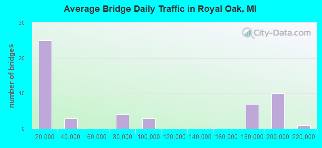
- 4,158,553Total average daily traffic
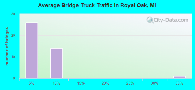
- 186,851Total average daily truck traffic
- National Bridge Inventory (NBI) Registered Bridges for Royal Oak
- No street view available for this location
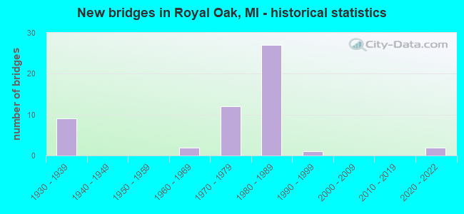
- New bridges - historical statistics
- 91930-1939
- 21960-1969
- 121970-1979
- 271980-1989
- 11990-1999
- 22020-2022
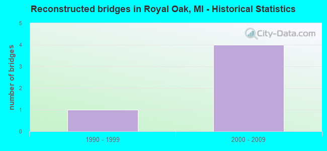
- Reconstructed bridges - Historical Statistics
- 11990-1999
- 42000-2009
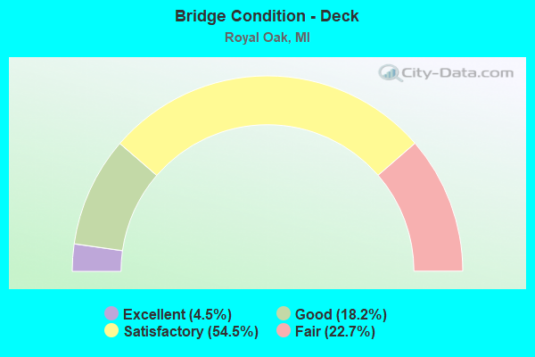
- Bridge Condition - Deck
- 4.5%Excellent
- 18.2%Good
- 54.5%Satisfactory
- 22.7%Fair
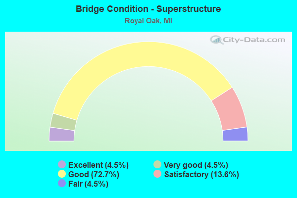
- Bridge Condition - Superstructure
- 4.5%Excellent
- 4.5%Very good
- 72.7%Good
- 13.6%Satisfactory
- 4.5%Fair
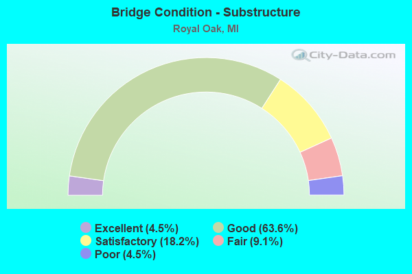
- Bridge Condition - Substructure
- 4.5%Excellent
- 63.6%Good
- 18.2%Satisfactory
- 9.1%Fair
- 4.5%Poor
Find on map >> Show street view
Structure Number: 798, Location: 0.7 MI NE OF NEW BUFFALO (Lat: 41.799117, Lng: -86.706122), Route carried "on" structure: Interstate 94, Year Built: 1998, Status: Open, Structure Length: 7.31m (23.98ft), Average Daily Traffic: 19,340 (year 2007), Truck Traffic: 31%, Average Future Daily Traffic: 25,386 (year 2018), Design Load: HS 25 or greater, Features Intersected: US-12
Minimum Vertical Clearance: 30.48m (100.00ft), Kilometerpoint: 5.739, Lanes on structure: 4, Lanes under structure: 6, Base Highway Network: Yes (Inventory Route: 136, Subroute: 4), Owner: State Highway Agency, Approaching Roadway Width: 22.0m (72.2ft), Skew: 2 degrees, Material/Design: Prestressed concrete, Design/Construction: Box Beam or Girders - Multiple, Number Of Spans In Main Unit: 4, Length of Maximum Span: 24.0m (78.7ft), Curb-To-Curb Width: 22.0m (72.2ft), Out-to-Out Width: 22.9m (75.1ft)
Condition: Deck: Satisfactory, Superstructure: Satisfactory, Substructure: Good, Operating Rating: 84.3 metric tons, Method Used To Determine Operating Rating: Load Factor (LF), Inventory Rating: 47.9 metric tons, Method Used To Determine Inventory Rating: Load Factor (LF), Structural Evaluation: Equal to present minimum criteria, Deck Geometry: Better than present minimum criteria, Underclear: High priority of corrective action, Approach Roadway Alignment: Equal to present desirable criteria, Designated Inspection Frequency: Every 24 months, Inspection Date: October 2020, Deck Structure Type: Concrete Cast-file-Place, Wearing Surface/Protective System: Wearing Surface: Monolithic Concrete, Deck Protection: Epoxy Coated Reinforcing
Find on map >> Show street view
Structure Number: 7936, Location: IN ROYAL OAK (Lat: 42.475233, Lng: -83.147147), Route carried "on" structure: Ramp State highway 1, Year Built: 1986, Status: Open, Structure Length: 4.71m (15.45ft), Average Daily Traffic: 20,000 (year 1982), Truck Traffic: 3%, Average Future Daily Traffic: 21,000 (year 2000), Design Load: HS 25 or greater, Features Intersected: I-696, Facility Carried by Structure: WOODWARD U TURN W
Minimum Vertical Clearance: 30.48m (100.00ft), Kilometerpoint: 0.230, Lanes on structure: 4, Lanes under structure: 8, Owner: State Highway Agency, Approaching Roadway Width: 14.6m (47.9ft), Skew: 30 degrees, Material/Design: Prestressed concrete, Design/Construction: Stringer/Multi-beam, Number Of Spans In Main Unit: 2, Length of Maximum Span: 23.6m (77.4ft), Curb or Sidewalk Widths: Left: 0.2m (0.7ft), Right: 0.2m (0.7ft), Curb-To-Curb Width: 22.0m (72.2ft), Out-to-Out Width: 23.3m (76.4ft)
Condition: Deck: Satisfactory, Superstructure: Good, Substructure: Good, Operating Rating: 64.2 metric tons, Method Used To Determine Operating Rating: Load Factor (LF) rating reported by rating factor (RF) method using MS18 loading, Inventory Rating: 22.0 metric tons, Method Used To Determine Inventory Rating: Load Factor (LF) rating reported by rating factor (RF) method using MS18 loading, Structural Evaluation: Somewhat better than minimum adequacy, Deck Geometry: Superior to present desirable criteria, Underclear: Equal to present minimum criteria, Approach Roadway Alignment: Equal to present desirable criteria, Designated Inspection Frequency: Every 24 months, Inspection Date: July 2020, Deck Structure Type: Concrete Cast-file-Place, Wearing Surface/Protective System: Wearing Surface: Monolithic Concrete, Deck Protection: Epoxy Coated Reinforcing
Find on map >> Show street view
Structure Number: 7937, Location: AT I-696 & WOODWARD (Lat: 42.475561, Lng: -83.145703), Route carried "on" structure: ServiceInterstate 696, Year Built: 1986, Status: Open, Structure Length: 3.75m (12.30ft), Average Daily Traffic: 93,000 (year 1995), Truck Traffic: 5%, Average Future Daily Traffic: 102,280 (year 2015), Design Load: HS 25 or greater, Features Intersected: M-1 (WOODWARD AVE)
Minimum Vertical Clearance: 30.48m (100.00ft), Kilometerpoint: 3.721, Lanes on structure: 6, Lanes under structure: 4, Owner: State Highway Agency, Approaching Roadway Width: 14.6m (47.9ft), Skew: 33 degrees, Material/Design: Prestressed concrete, Design/Construction: Stringer/Multi-beam, Number Of Spans In Main Unit: 2, Length of Maximum Span: 19.2m (63.0ft), Curb or Sidewalk Widths: Left: 0.0m, Right: 5.0m (16.4ft), Curb-To-Curb Width: 29.3m (96.1ft), Out-to-Out Width: 35.0m (114.8ft)
Condition: Deck: Fair, Superstructure: Good, Substructure: Satisfactory, Operating Rating: 57.0 metric tons, Method Used To Determine Operating Rating: Load Factor (LF) rating reported by rating factor (RF) method using MS18 loading, Inventory Rating: 34.0 metric tons, Method Used To Determine Inventory Rating: Load Factor (LF) rating reported by rating factor (RF) method using MS18 loading, Structural Evaluation: Equal to present minimum criteria, Deck Geometry: Better than present minimum criteria, Underclear: Equal to present minimum criteria, Approach Roadway Alignment: Equal to present desirable criteria, Designated Inspection Frequency: Every 24 months, Inspection Date: July 2021, Deck Structure Type: Concrete Cast-file-Place, Wearing Surface/Protective System: Wearing Surface: Monolithic Concrete, Deck Protection: Epoxy Coated Reinforcing
Find on map >> Show street view
Structure Number: 7938, Location: AT I-696 & WOODWARD (Lat: 42.475111, Lng: -83.145661), Route carried "on" structure: ServiceState highway 1, Year Built: 1986, Status: Open, Structure Length: 5.64m (18.50ft), Average Daily Traffic: 1,500 (year 1982), Truck Traffic: 3%, Average Future Daily Traffic: 1,500 (year 2000), Design Load: HS 25 or greater, Features Intersected: I-696, Facility Carried by Structure: SB WOODWARD SERV
Minimum Vertical Clearance: 30.48m (100.00ft), Kilometerpoint: 0.798, Lanes on structure: 3, Lanes under structure: 8, Owner: State Highway Agency, Approaching Roadway Width: 10.0m (32.8ft), Skew: 3 degrees, Material/Design: Prestressed concrete, Design/Construction: Stringer/Multi-beam, Number Of Spans In Main Unit: 2, Length of Maximum Span: 28.2m (92.5ft), Curb or Sidewalk Widths: Left: 2.4m (7.9ft), Right: 2.4m (7.9ft), Curb-To-Curb Width: 11.3m (37.1ft), Out-to-Out Width: 16.9m (55.4ft)
Condition: Deck: Satisfactory, Superstructure: Good, Substructure: Good, Operating Rating: 65.8 metric tons, Method Used To Determine Operating Rating: Load Factor (LF) rating reported by rating factor (RF) method using MS18 loading, Inventory Rating: 34.7 metric tons, Method Used To Determine Inventory Rating: Load Factor (LF) rating reported by rating factor (RF) method using MS18 loading, Structural Evaluation: Better than present minimum criteria, Deck Geometry: High priority of replacement, Underclear: Meets minimum limits, Approach Roadway Alignment: Equal to present desirable criteria, Designated Inspection Frequency: Every 24 months, Inspection Date: July 2020, Deck Structure Type: Concrete Cast-file-Place, Wearing Surface/Protective System: Wearing Surface: Monolithic Concrete, Deck Protection: Epoxy Coated Reinforcing
Find on map >> Show street view
Structure Number: 794, Location: AT I-696 & WOODWARD (Lat: 42.475131, Lng: -83.144994), Route carried "on" structure: ServiceState highway 1, Year Built: 1986, Status: Open, Structure Length: 5.70m (18.70ft), Average Daily Traffic: 1,500 (year 1982), Truck Traffic: 3%, Average Future Daily Traffic: 1,500 (year 2010), Design Load: HS 25 or greater, Features Intersected: I-696, Facility Carried by Structure: NB WOODWARD SERV
Minimum Vertical Clearance: 30.48m (100.00ft), Kilometerpoint: 0.735, Lanes on structure: 3, Lanes under structure: 8, Owner: State Highway Agency, Approaching Roadway Width: 14.6m (47.9ft), Skew: 3 degrees, Material/Design: Prestressed concrete, Design/Construction: Stringer/Multi-beam, Number Of Spans In Main Unit: 2, Length of Maximum Span: 28.3m (92.8ft), Curb or Sidewalk Widths: Left: 2.4m (7.9ft), Right: 2.4m (7.9ft), Curb-To-Curb Width: 11.2m (36.7ft), Out-to-Out Width: 16.9m (55.4ft)
Condition: Deck: Fair, Superstructure: Good, Substructure: Good, Operating Rating: 71.3 metric tons, Method Used To Determine Operating Rating: Load Factor (LF) rating reported by rating factor (RF) method using MS18 loading, Inventory Rating: 36.6 metric tons, Method Used To Determine Inventory Rating: Load Factor (LF) rating reported by rating factor (RF) method using MS18 loading, Structural Evaluation: Better than present minimum criteria, Deck Geometry: High priority of replacement, Underclear: Meets minimum limits, Approach Roadway Alignment: Equal to present desirable criteria, Designated Inspection Frequency: Every 24 months, Inspection Date: July 2021, Deck Structure Type: Concrete Cast-file-Place, Wearing Surface/Protective System: Wearing Surface: Monolithic Concrete, Deck Protection: Epoxy Coated Reinforcing
Find on map >> Show street view
Structure Number: 7941, Location: IN ROYAL OAK (Lat: 42.475144, Lng: -83.143708), Route carried "on" structure: City street , Year Built: 1986, Status: Open, Structure Length: 4.69m (15.39ft), Average Daily Traffic: 13,100 (year 1993), Truck Traffic: 3%, Average Future Daily Traffic: 13,100 (year 2000), Design Load: HS 25 or greater, Features Intersected: I-696, Facility Carried by Structure: MAIN STREET
Minimum Vertical Clearance: 30.48m (100.00ft), Kilometerpoint: 0.164, Lanes on structure: 5, Lanes under structure: 8, Base Highway Network: Yes (Inventory Route: 64, Subroute: 6), Owner: State Highway Agency, Approaching Roadway Width: 14.6m (47.9ft), Material/Design: Prestressed concrete, Design/Construction: Stringer/Multi-beam, Number Of Spans In Main Unit: 2, Length of Maximum Span: 23.4m (76.8ft), Curb-To-Curb Width: 25.7m (84.3ft), Out-to-Out Width: 26.9m (88.3ft)
Condition: Deck: Fair, Superstructure: Good, Substructure: Good, Operating Rating: 62.5 metric tons, Method Used To Determine Operating Rating: Load Factor (LF) rating reported by rating factor (RF) method using MS18 loading, Inventory Rating: 32.7 metric tons, Method Used To Determine Inventory Rating: Load Factor (LF) rating reported by rating factor (RF) method using MS18 loading, Structural Evaluation: Better than present minimum criteria, Deck Geometry: Superior to present desirable criteria, Underclear: Equal to present minimum criteria, Approach Roadway Alignment: Superior to present desirable criteria, Designated Inspection Frequency: Every 24 months, Inspection Date: July 2021, Deck Structure Type: Concrete Cast-file-Place, Wearing Surface/Protective System: Wearing Surface: Monolithic Concrete, Deck Protection: Epoxy Coated Reinforcing
Find on map >> Show street view
Structure Number: 7942, Location: IN ROYAL OAK (Lat: 42.475778, Lng: -83.133078), Route carried "on" structure: City street , Year Built: 1983, Status: Open, Structure Length: 5.49m (18.01ft), Average Daily Traffic: 4,500 (year 1993), Truck Traffic: 3%, Average Future Daily Traffic: 5,175 (year 2013), Design Load: HS 25 or greater, Features Intersected: I-696, Facility Carried by Structure: MOHAWK AVENUE
Minimum Vertical Clearance: 30.48m (100.00ft), Kilometerpoint: 0.761, Lanes on structure: 4, Lanes under structure: 10, Owner: State Highway Agency, Approaching Roadway Width: 15.8m (51.8ft), Material/Design: Prestressed concrete, Design/Construction: Stringer/Multi-beam, Number Of Spans In Main Unit: 2, Length of Maximum Span: 27.6m (90.6ft), Curb or Sidewalk Widths: Left: 1.5m (4.9ft), Right: 0.2m (0.7ft), Curb-To-Curb Width: 25.3m (83.0ft), Out-to-Out Width: 27.9m (91.5ft)
Condition: Deck: Satisfactory, Superstructure: Good, Substructure: Good, Operating Rating: 63.2 metric tons, Method Used To Determine Operating Rating: Load Factor (LF) rating reported by rating factor (RF) method using MS18 loading, Inventory Rating: 31.4 metric tons, Method Used To Determine Inventory Rating: Load Factor (LF) rating reported by rating factor (RF) method using MS18 loading, Structural Evaluation: Better than present minimum criteria, Deck Geometry: Superior to present desirable criteria, Underclear: Somewhat better than minimum adequacy, Approach Roadway Alignment: Equal to present desirable criteria, Designated Inspection Frequency: Every 24 months, Inspection Date: July 2020, Deck Structure Type: Concrete Cast-file-Place, Wearing Surface/Protective System: Wearing Surface: Monolithic Concrete, Deck Protection: Epoxy Coated Reinforcing
Find on map >> Show street view
Structure Number: 7943, Location: IN ROYAL OAK (Lat: 42.475722, Lng: -83.132903), Route carried "on" structure: ServiceCity street , Year Built: 1984, Status: Open, Structure Length: 5.48m (17.98ft), Average Daily Traffic: 1,559 (year 1992), Truck Traffic: 3%, Average Future Daily Traffic: 1,793 (year 2012), Design Load: HS 20, Features Intersected: I-696, Facility Carried by Structure: MOHAWK AVENUE(UTN)
Minimum Vertical Clearance: 30.48m (100.00ft), Kilometerpoint: 0.061, Lanes on structure: 1, Lanes under structure: 10, Owner: State Highway Agency, Approaching Roadway Width: 7.3m (24.0ft), Material/Design: Prestressed concrete, Design/Construction: Stringer/Multi-beam, Number Of Spans In Main Unit: 2, Length of Maximum Span: 27.4m (89.9ft), Curb or Sidewalk Widths: Left: 0.2m (0.7ft), Right: 2.0m (6.6ft), Curb-To-Curb Width: 6.4m (21.0ft), Out-to-Out Width: 9.0m (29.5ft)
Condition: Deck: Good, Superstructure: Good, Substructure: Good, Operating Rating: 64.5 metric tons, Method Used To Determine Operating Rating: Load Factor (LF) rating reported by rating factor (RF) method using MS18 loading, Inventory Rating: 30.1 metric tons, Method Used To Determine Inventory Rating: Load Factor (LF) rating reported by rating factor (RF) method using MS18 loading, Structural Evaluation: Better than present minimum criteria, Deck Geometry: High priority of replacement, Underclear: Somewhat better than minimum adequacy, Approach Roadway Alignment: Equal to present desirable criteria, Designated Inspection Frequency: Every 24 months, Inspection Date: July 2020, Deck Structure Type: Concrete Cast-file-Place, Wearing Surface/Protective System: Wearing Surface: Monolithic Concrete, Deck Protection: Epoxy Coated Reinforcing
Find on map >> Show street view
Structure Number: 7944, Location: IN ROYAL OAK (Lat: 42.475975, Lng: -83.123767), Route carried "on" structure: City street , Year Built: 1983, Status: Open, Structure Length: 5.51m (18.08ft), Average Daily Traffic: 15,500 (year 1988), Truck Traffic: 3%, Average Future Daily Traffic: 17,825 (year 2008), Design Load: HS 25 or greater, Features Intersected: I-696, Facility Carried by Structure: CAMPBELL AVE
Minimum Vertical Clearance: 30.48m (100.00ft), Kilometerpoint: 0.029, Lanes on structure: 8, Lanes under structure: 10, Owner: State Highway Agency, Approaching Roadway Width: 15.8m (51.8ft), Material/Design: Prestressed concrete, Design/Construction: Stringer/Multi-beam, Number Of Spans In Main Unit: 2, Length of Maximum Span: 27.8m (91.2ft), Curb or Sidewalk Widths: Left: 0.2m (0.7ft), Right: 0.2m (0.7ft), Curb-To-Curb Width: 38.3m (125.7ft), Out-to-Out Width: 39.6m (129.9ft)
Condition: Deck: Satisfactory, Superstructure: Good, Substructure: Satisfactory, Operating Rating: 57.0 metric tons, Method Used To Determine Operating Rating: Load Factor (LF) rating reported by rating factor (RF) method using MS18 loading, Inventory Rating: 25.6 metric tons, Method Used To Determine Inventory Rating: Load Factor (LF) rating reported by rating factor (RF) method using MS18 loading, Structural Evaluation: Equal to present minimum criteria, Deck Geometry: Superior to present desirable criteria, Underclear: High priority of corrective action, Approach Roadway Alignment: Equal to present desirable criteria, Designated Inspection Frequency: Every 24 months, Inspection Date: July 2020, Deck Structure Type: Concrete Cast-file-Place, Wearing Surface/Protective System: Wearing Surface: Monolithic Concrete, Deck Protection: Epoxy Coated Reinforcing
Find on map >> Show street view
Structure Number: 7955, Location: AT I-696 & WOODWARD (Lat: 42.476603, Lng: -83.146667), Route carried "on" structure: City street , Year Built: 1986, Status: Open, Structure Length: 2.94m (9.65ft), Average Daily Traffic: 11,000 (year 2018), Truck Traffic: 2%, Average Future Daily Traffic: 12,650 (year 2038), Design Load: HS 25 or greater, Features Intersected: M-1 WOODWARD, Facility Carried by Structure: WASHINGTON
Minimum Vertical Clearance: 30.48m (100.00ft), Kilometerpoint: 0.053, Lanes on structure: 3, Lanes under structure: 4, Owner: State Highway Agency, Approaching Roadway Width: 12.2m (40.0ft), Material/Design: Prestressed concrete, Design/Construction: Stringer/Multi-beam, Number Of Spans In Main Unit: 2, Length of Maximum Span: 14.7m (48.2ft), Curb or Sidewalk Widths: Left: 1.8m (5.9ft), Right: 0.0m, Curb-To-Curb Width: 12.0m (39.4ft), Out-to-Out Width: 20.8m (68.2ft)
Condition: Deck: Satisfactory, Superstructure: Very good, Substructure: Good, Operating Rating: 57.3 metric tons, Method Used To Determine Operating Rating: Load Factor (LF) rating reported by rating factor (RF) method using MS18 loading, Inventory Rating: 32.1 metric tons, Method Used To Determine Inventory Rating: Load Factor (LF) rating reported by rating factor (RF) method using MS18 loading, Structural Evaluation: Better than present minimum criteria, Deck Geometry: Meets minimum limits, Underclear: Meets minimum limits, Approach Roadway Alignment: Equal to present desirable criteria, Designated Inspection Frequency: Every 24 months, Inspection Date: July 2020, Deck Structure Type: Concrete Cast-file-Place, Wearing Surface/Protective System: Wearing Surface: Monolithic Concrete, Deck Protection: Epoxy Coated Reinforcing
Find on map >> Show street view
Structure Number: 7956, Location: AT WOODWARD & I-696 (Lat: 42.475275, Lng: -83.145411), Route carried "on" structure: Interstate 696, Year Built: 1986, Status: Open, Structure Length: 3.72m (12.20ft), Average Daily Traffic: 98,750 (year 2007), Truck Traffic: 4%, Average Future Daily Traffic: 104,912 (year 2018), Design Load: HS 25 or greater, Features Intersected: M-1 WOODWARD
Minimum Vertical Clearance: 30.48m (100.00ft), Kilometerpoint: 4.606, Lanes on structure: 4, Lanes under structure: 4, Base Highway Network: Yes (Inventory Route: 190, Subroute: 2), Owner: State Highway Agency, Approaching Roadway Width: 14.6m (47.9ft), Skew: 3 degrees, Material/Design: Prestressed concrete, Design/Construction: Stringer/Multi-beam, Number Of Spans In Main Unit: 2, Length of Maximum Span: 19.0m (62.3ft), Curb or Sidewalk Widths: Left: 0.2m (0.7ft), Right: 0.0m, Curb-To-Curb Width: 21.9m (71.9ft), Out-to-Out Width: 23.2m (76.1ft)
Condition: Deck: Satisfactory, Superstructure: Good, Substructure: Good, Operating Rating: 76.5 metric tons, Method Used To Determine Operating Rating: Load Factor (LF) rating reported by rating factor (RF) method using MS18 loading, Inventory Rating: 37.9 metric tons, Method Used To Determine Inventory Rating: Load Factor (LF) rating reported by rating factor (RF) method using MS18 loading, Structural Evaluation: Better than present minimum criteria, Deck Geometry: Better than present minimum criteria, Underclear: Equal to present minimum criteria, Approach Roadway Alignment: Equal to present desirable criteria, Designated Inspection Frequency: Every 24 months, Inspection Date: July 2020, Deck Structure Type: Concrete Cast-file-Place, Wearing Surface/Protective System: Wearing Surface: Monolithic Concrete, Deck Protection: Epoxy Coated Reinforcing
Find on map >> Show street view
Structure Number: 7957, Location: AT I-696 & WOODWARD (Lat: 42.475122, Lng: -83.145275), Route carried "on" structure: Interstate 696, Year Built: 1986, Status: Open, Structure Length: 3.72m (12.20ft), Average Daily Traffic: 98,750 (year 2007), Truck Traffic: 4%, Average Future Daily Traffic: 104,912 (year 2018), Design Load: HS 25 or greater, Features Intersected: M-1 WOODWARD
Minimum Vertical Clearance: 30.48m (100.00ft), Kilometerpoint: 4.611, Lanes on structure: 4, Lanes under structure: 4, Base Highway Network: Yes (Inventory Route: 190, Subroute: 3), Owner: State Highway Agency, Approaching Roadway Width: 14.6m (47.9ft), Skew: 3 degrees, Material/Design: Prestressed concrete, Design/Construction: Stringer/Multi-beam, Number Of Spans In Main Unit: 2, Length of Maximum Span: 18.9m (62.0ft), Curb-To-Curb Width: 21.9m (71.9ft), Out-to-Out Width: 23.2m (76.1ft)
Condition: Deck: Satisfactory, Superstructure: Good, Substructure: Good, Operating Rating: 71.9 metric tons, Method Used To Determine Operating Rating: Load Factor (LF) rating reported by rating factor (RF) method using MS18 loading, Inventory Rating: 43.1 metric tons, Method Used To Determine Inventory Rating: Load Factor (LF) rating reported by rating factor (RF) method using MS18 loading, Structural Evaluation: Better than present minimum criteria, Deck Geometry: Better than present minimum criteria, Underclear: Equal to present minimum criteria, Approach Roadway Alignment: Equal to present desirable criteria, Designated Inspection Frequency: Every 24 months, Inspection Date: July 2020, Deck Structure Type: Concrete Cast-file-Place, Wearing Surface/Protective System: Wearing Surface: Monolithic Concrete, Deck Protection: Epoxy Coated Reinforcing
Find on map >> Show street view
Structure Number: 7963, Location: IN CITY OF ROYAL OAK (Lat: 42.476222, Lng: -83.115008), Route carried "on" structure: Interstate 696, Year Built: 1982, Status: Open, Structure Length: 2.35m (7.71ft), Average Daily Traffic: 192,100 (year 2007), Truck Traffic: 4%, Average Future Daily Traffic: 213,266 (year 2018), Design Load: HS 25 or greater, Features Intersected: N-S SERVICE ROAD
Minimum Vertical Clearance: 30.48m (100.00ft), Kilometerpoint: 7.123, Lanes on structure: 5, Lanes under structure: 2, Base Highway Network: Yes (Inventory Route: 190, Subroute: 3), Owner: State Highway Agency, Approaching Roadway Width: 10.9m (35.8ft), Skew: 30 degrees, Material/Design: Prestressed concrete, Design/Construction: Stringer/Multi-beam, Number Of Spans In Main Unit: 1, Length of Maximum Span: 23.5m (77.1ft), Curb-To-Curb Width: 47.1m (154.5ft), Out-to-Out Width: 49.8m (163.4ft)
Condition: Deck: Satisfactory, Superstructure: Good, Substructure: Good, Operating Rating: 79.4 metric tons, Method Used To Determine Operating Rating: Load Factor (LF) rating reported by rating factor (RF) method using MS18 loading, Inventory Rating: 47.3 metric tons, Method Used To Determine Inventory Rating: Load Factor (LF) rating reported by rating factor (RF) method using MS18 loading, Structural Evaluation: Better than present minimum criteria, Deck Geometry: Superior to present desirable criteria, Underclear: Equal to present minimum criteria, Approach Roadway Alignment: Equal to present minimum criteria, Designated Inspection Frequency: Every 24 months, Inspection Date: July 2021, Deck Structure Type: Concrete Cast-file-Place, Wearing Surface/Protective System: Wearing Surface: Monolithic Concrete, Deck Protection: Epoxy Coated Reinforcing
Find on map >> Show street view
Structure Number: 7964, Location: AT I-696 & I-75 (Lat: 42.476706, Lng: -83.114961), Route carried "on" structure: Ramp Interstate 696, Year Built: 1982, Status: Open, Structure Length: 2.50m (8.20ft), Average Daily Traffic: 30,200 (year 1982), Truck Traffic: 3%, Average Future Daily Traffic: 30,200 (year 1977), Design Load: HS 25 or greater, Features Intersected: N-S SERVICE ROAD
Minimum Vertical Clearance: 30.48m (100.00ft), Kilometerpoint: 0.518, Lanes on structure: 2, Lanes under structure: 2, Owner: State Highway Agency, Approaching Roadway Width: 10.9m (35.8ft), Skew: 3 degrees, Material/Design: Steel, Design/Construction: Stringer/Multi-beam, Number Of Spans In Main Unit: 1, Length of Maximum Span: 25.0m (82.0ft), Curb-To-Curb Width: 17.3m (56.8ft), Out-to-Out Width: 18.5m (60.7ft)
Condition: Deck: Good, Superstructure: Good, Substructure: Good, Operating Rating: 72.3 metric tons, Method Used To Determine Operating Rating: Load Factor (LF) rating reported by rating factor (RF) method using MS18 loading, Inventory Rating: 43.4 metric tons, Method Used To Determine Inventory Rating: Load Factor (LF) rating reported by rating factor (RF) method using MS18 loading, Structural Evaluation: Better than present minimum criteria, Deck Geometry: Superior to present desirable criteria, Underclear: Meets minimum limits, Approach Roadway Alignment: Equal to present desirable criteria, Designated Inspection Frequency: Every 24 months, Inspection Date: July 2021, Deck Structure Type: Concrete Cast-file-Place, Wearing Surface/Protective System: Wearing Surface: Epoxy Overlay, Deck Protection: Other
Find on map >> Show street view
Structure Number: 7966, Location: IN ROYAL OAK (Lat: 42.476528, Lng: -83.111386), Route carried "on" structure: Interstate 696, Year Built: 1971, Status: Open, Structure Length: 20.42m (66.99ft), Average Daily Traffic: 209,200 (year 2007), Truck Traffic: 4%, Average Future Daily Traffic: 222,094 (year 2018), Design Load: HS 20+Mod, Features Intersected: I-75 & 4 RAMPS
Minimum Vertical Clearance: 4.87m (15.98ft), Kilometerpoint: 7.408, Lanes on structure: 8, Lanes under structure: 2, Base Highway Network: Yes (Inventory Route: 190, Subroute: 3), Owner: State Highway Agency, Approaching Roadway Width: 36.5m (119.8ft), Skew: 30 degrees, Material/Design: Steel continuous, Design/Construction: Stringer/Multi-beam, Number Of Spans In Main Unit: 3, Number Of Approach Spans: 2, Length of Maximum Span: 48.8m (160.1ft), Curb-To-Curb Width: 44.0m (144.4ft), Out-to-Out Width: 46.5m (152.6ft)
Condition: Deck: Satisfactory, Superstructure: Fair, Substructure: Poor, Operating Rating: 79.1 metric tons, Method Used To Determine Operating Rating: Load Factor (LF) rating reported by rating factor (RF) method using MS18 loading, Inventory Rating: 47.3 metric tons, Method Used To Determine Inventory Rating: Load Factor (LF) rating reported by rating factor (RF) method using MS18 loading, Structural Evaluation: Meets minimum limits, Deck Geometry: Superior to present desirable criteria, Underclear: Somewhat better than minimum adequacy, Approach Roadway Alignment: Equal to present desirable criteria, Length Of Structure Improvement: 20.43m (67.03ft), Designated Inspection Frequency: Every 24 months, Critical Feature Inspection Frequency: Every 15 months, Other Special Inspection Frequency: Every 12 months, Inspection Date: July 2020, Critical Feature Inspection Date: June 2021, Other Special Inspection Date: May 2021, Bridge Improvement Cost: $1,246,000, Roadway Improvement Cost: $81,000, Total Project Cost: $954,000, Deck Structure Type: Concrete Cast-file-Place, Wearing Surface/Protective System: Wearing Surface: Epoxy Overlay
Find on map >> Show street view
Structure Number: 7977, Location: @ I-75 (Lat: 42.476417, Lng: -83.111525), Route carried "on" structure: Ramp Interstate 696, Year Built: 1971, Year Reconstructed: 2007, Status: Open, Structure Length: 12.44m (40.81ft), Average Daily Traffic: 17,000 (year 1982), Truck Traffic: 5%, Average Future Daily Traffic: 17,000 (year 1977), Design Load: HS 20+Mod, Features Intersected: I-696&RAMPS FROM I-75NB
Minimum Vertical Clearance: 5.16m (16.93ft), Kilometerpoint: 0.217, Lanes on structure: 2, Lanes under structure: 2, Owner: State Highway Agency, Approaching Roadway Width: 12.2m (40.0ft), Skew: 9 degrees, Material/Design: Steel, Design/Construction: Stringer/Multi-beam, Number Of Spans In Main Unit: 4, Length of Maximum Span: 37.3m (122.4ft), Curb-To-Curb Width: 12.0m (39.4ft), Out-to-Out Width: 13.5m (44.3ft)
Condition: Deck: Fair, Superstructure: Good, Substructure: Good, Operating Rating: 64.2 metric tons, Method Used To Determine Operating Rating: Load Factor (LF) rating reported by rating factor (RF) method using MS18 loading, Inventory Rating: 38.6 metric tons, Method Used To Determine Inventory Rating: Load Factor (LF) rating reported by rating factor (RF) method using MS18 loading, Structural Evaluation: Better than present minimum criteria, Deck Geometry: Better than present minimum criteria, Underclear: High priority of corrective action, Approach Roadway Alignment: Equal to present desirable criteria, Designated Inspection Frequency: Every 24 months, Critical Feature Inspection Frequency: Every 24 months, Inspection Date: July 2021, Critical Feature Inspection Date: April 2021, Deck Structure Type: Concrete Cast-file-Place, Wearing Surface/Protective System: Wearing Surface: Latex Concrete
Find on map >> Show street view
Structure Number: 7978, Location: @ I-75 (Lat: 42.476692, Lng: -83.111717), Route carried "on" structure: Ramp Interstate 696, Year Built: 1971, Year Reconstructed: 2007, Status: Open, Structure Length: 12.44m (40.81ft), Average Daily Traffic: 17,000 (year 1982), Truck Traffic: 5%, Average Future Daily Traffic: 17,000 (year 1977), Design Load: HS 20+Mod, Features Intersected: I-696&RAMPS FROM I-75 SB
Minimum Vertical Clearance: 5.23m (17.16ft), Kilometerpoint: 0.227, Lanes on structure: 1, Lanes under structure: 2, Owner: State Highway Agency, Approaching Roadway Width: 12.2m (40.0ft), Skew: 9 degrees, Material/Design: Steel, Design/Construction: Stringer/Multi-beam, Number Of Spans In Main Unit: 4, Length of Maximum Span: 37.2m (122.0ft), Curb-To-Curb Width: 12.0m (39.4ft), Out-to-Out Width: 13.5m (44.3ft)
Condition: Deck: Satisfactory, Superstructure: Good, Substructure: Fair, Operating Rating: 64.8 metric tons, Method Used To Determine Operating Rating: Load Factor (LF) rating reported by rating factor (RF) method using MS18 loading, Inventory Rating: 38.9 metric tons, Method Used To Determine Inventory Rating: Load Factor (LF) rating reported by rating factor (RF) method using MS18 loading, Structural Evaluation: Somewhat better than minimum adequacy, Deck Geometry: Superior to present desirable criteria, Underclear: High priority of corrective action, Approach Roadway Alignment: Equal to present desirable criteria, Designated Inspection Frequency: Every 24 months, Critical Feature Inspection Frequency: Every 24 months, Other Special Inspection Frequency: Every 6 months, Inspection Date: July 2021, Critical Feature Inspection Date: July 2021, Other Special Inspection Date: January 2022, Deck Structure Type: Concrete Cast-file-Place, Wearing Surface/Protective System: Wearing Surface: Latex Concrete
Find on map >> Show street view
Structure Number: 7979, Location: @I-75 (Lat: 42.477169, Lng: -83.111472), Route carried "on" structure: Ramp Interstate 696, Year Built: 1971, Year Reconstructed: 2007, Status: Open, Structure Length: 9.81m (32.19ft), Average Daily Traffic: 5,100 (year 1982), Truck Traffic: 5%, Average Future Daily Traffic: 5,100 (year 1977), Design Load: HS 20+Mod, Features Intersected: I-75 & RAMPS TO I-75 NB
Minimum Vertical Clearance: 4.90m (16.08ft), Kilometerpoint: 0.235, Lanes on structure: 1, Lanes under structure: 6, Owner: State Highway Agency, Approaching Roadway Width: 8.2m (26.9ft), Skew: 9 degrees, Material/Design: Steel, Design/Construction: Stringer/Multi-beam, Number Of Spans In Main Unit: 4, Length of Maximum Span: 41.8m (137.1ft), Curb-To-Curb Width: 4.9m (16.1ft), Out-to-Out Width: 9.0m (29.5ft)
Condition: Deck: Fair, Superstructure: Satisfactory, Substructure: Good, Operating Rating: 47.3 metric tons, Method Used To Determine Operating Rating: Load and Resistance Factor Rating (LRFR) rating reported by rating factor(RF) method using HL-93 loadings, Inventory Rating: 36.6 metric tons, Method Used To Determine Inventory Rating: Load and Resistance Factor Rating (LRFR) rating reported by rating factor(RF) method using HL-93 loadings, Structural Evaluation: Equal to present minimum criteria, Deck Geometry: High priority of corrective action, Underclear: High priority of corrective action, Approach Roadway Alignment: Equal to present desirable criteria, Designated Inspection Frequency: Every 24 months, Inspection Date: July 2021, Deck Structure Type: Concrete Cast-file-Place, Wearing Surface/Protective System: Wearing Surface: Latex Concrete
Find on map >> Show street view
Structure Number: 798, Location: I-75 / I-696 INTRCHG (Lat: 42.476083, Lng: -83.111944), Route carried "on" structure: Ramp Interstate 696, Year Built: 1971, Year Reconstructed: 2007, Status: Open, Structure Length: 9.63m (31.59ft), Average Daily Traffic: 17,000 (year 1982), Truck Traffic: 5%, Average Future Daily Traffic: 17,000 (year 1977), Design Load: HS 20+Mod, Features Intersected: I-75 & RAMPS TO I-75 SB
Minimum Vertical Clearance: 5.00m (16.40ft), Kilometerpoint: 0.288, Lanes on structure: 1, Lanes under structure: 6, Owner: State Highway Agency, Approaching Roadway Width: 8.2m (26.9ft), Skew: 9 degrees, Material/Design: Steel, Design/Construction: Stringer/Multi-beam, Number Of Spans In Main Unit: 4, Length of Maximum Span: 41.8m (137.1ft), Curb-To-Curb Width: 6.9m (22.6ft), Out-to-Out Width: 9.0m (29.5ft)
Condition: Deck: Satisfactory, Superstructure: Satisfactory, Substructure: Satisfactory, Operating Rating: 63.8 metric tons, Method Used To Determine Operating Rating: Load Factor (LF) rating reported by rating factor (RF) method using MS18 loading, Inventory Rating: 38.2 metric tons, Method Used To Determine Inventory Rating: Load Factor (LF) rating reported by rating factor (RF) method using MS18 loading, Structural Evaluation: Equal to present minimum criteria, Deck Geometry: High priority of corrective action, Underclear: High priority of corrective action, Approach Roadway Alignment: Equal to present desirable criteria, Designated Inspection Frequency: Every 24 months, Inspection Date: July 2021, Deck Structure Type: Concrete Cast-file-Place, Wearing Surface/Protective System: Wearing Surface: Latex Concrete
Find on map >> Show street view
Structure Number: 8056, Location: IN ROYAL OAK (Lat: 42.498403, Lng: -83.117225), Route carried "on" structure: City street , Year Built: 1963, Year Reconstructed: 1996, Status: Open, Structure Length: 3.89m (12.76ft), Average Daily Traffic: 8,070 (year 1996), Average Future Daily Traffic: 8,070 (year 2016), Design Load: HS 20, Features Intersected: I-75, Facility Carried by Structure: GARDENIA RD
Minimum Vertical Clearance: 30.48m (100.00ft), Kilometerpoint: 2.289, Lanes on structure: 4, Lanes under structure: 6, Owner: State Highway Agency, Approaching Roadway Width: 13.4m (44.0ft), Material/Design: Concrete, Design/Construction: Box Beam or Girders - Single/Spread, Number Of Spans In Main Unit: 2, Length of Maximum Span: 19.0m (62.3ft), Curb or Sidewalk Widths: Left: 1.8m (5.9ft), Right: 1.8m (5.9ft), Curb-To-Curb Width: 13.4m (44.0ft), Out-to-Out Width: 17.8m (58.4ft)
Condition: Deck: Good, Superstructure: Good, Substructure: Fair, Operating Rating: 64.2 metric tons, Method Used To Determine Operating Rating: Load Factor (LF), Inventory Rating: 38.4 metric tons, Method Used To Determine Inventory Rating: Load Factor (LF), Structural Evaluation: Somewhat better than minimum adequacy, Deck Geometry: High priority of replacement, Underclear: Somewhat better than minimum adequacy, Approach Roadway Alignment: Equal to present desirable criteria, Designated Inspection Frequency: Every 24 months, Inspection Date: July 2021, Deck Structure Type: Concrete Cast-file-Place, Wearing Surface/Protective System: Wearing Surface: Monolithic Concrete, Deck Protection: Epoxy Coated Reinforcing
Find on map >> Show street view
Structure Number: 8098, Location: @ CITY OF ROYAL OAK (Lat: 42.483286, Lng: -83.113539), Route carried "on" structure: City street , Year Built: 1971, Status: Open, Structure Length: 5.24m (17.19ft), Average Daily Traffic: 8,530 (year 1974), Truck Traffic: 3%, Average Future Daily Traffic: 8,530 (year 1977), Design Load: H 20, Features Intersected: I-75, Facility Carried by Structure: 10.5 MI ROAD
Minimum Vertical Clearance: 30.48m (100.00ft), Kilometerpoint: 5.549, Lanes on structure: 4, Lanes under structure: 8, Owner: State Highway Agency, Approaching Roadway Width: 15.8m (51.8ft), Skew: 1 degrees, Material/Design: Steel, Design/Construction: Stringer/Multi-beam, Number Of Spans In Main Unit: 2, Length of Maximum Span: 26.2m (86.0ft), Curb or Sidewalk Widths: Left: 1.8m (5.9ft), Right: 1.8m (5.9ft), Curb-To-Curb Width: 15.8m (51.8ft), Out-to-Out Width: 20.2m (66.3ft)
Condition: Deck: Good, Superstructure: Good, Substructure: Satisfactory, Operating Rating: 70.0 metric tons, Method Used To Determine Operating Rating: Load Factor (LF) rating reported by rating factor (RF) method using MS18 loading, Inventory Rating: 41.8 metric tons, Method Used To Determine Inventory Rating: Load Factor (LF) rating reported by rating factor (RF) method using MS18 loading, Structural Evaluation: Equal to present minimum criteria, Deck Geometry: Meets minimum limits, Underclear: Somewhat better than minimum adequacy, Approach Roadway Alignment: Equal to present desirable criteria, Length Of Structure Improvement: 5.24m (17.19ft), Designated Inspection Frequency: Every 24 months, Inspection Date: July 2021, Bridge Improvement Cost: $358,000, Roadway Improvement Cost: $16,000, Total Project Cost: $189,000, Deck Structure Type: Concrete Cast-file-Place, Wearing Surface/Protective System: Wearing Surface: Monolithic Concrete
Find on map >> Show street view
Structure Number: 8099, Location: IN ROYAL OAK (Lat: 42.490583, Lng: -83.116114), Route carried "on" structure: County highway 2059, Year Built: 2021, Status: Open, Structure Length: 5.09m (16.70ft), Average Daily Traffic: 3,600 (year 1974), Truck Traffic: 3%, Average Future Daily Traffic: 3,600 (year 1977), Design Load: Greater than HL93, Features Intersected: I-75, Facility Carried by Structure: 11 MI RD
Minimum Vertical Clearance: 30.48m (100.00ft), Kilometerpoint: 14.443, Lanes on structure: 6, Lanes under structure: 6, Owner: State Highway Agency, Approaching Roadway Width: 27.0m (88.6ft), Skew: 1 degrees, Material/Design: Prestressed concrete, Design/Construction: Stringer/Multi-beam, Number Of Spans In Main Unit: 2, Length of Maximum Span: 26.5m (86.9ft), Curb or Sidewalk Widths: Left: 1.8m (5.9ft), Right: 1.8m (5.9ft), Curb-To-Curb Width: 23.2m (76.1ft), Out-to-Out Width: 27.6m (90.6ft)
Condition: Deck: Excellent, Superstructure: Excellent, Substructure: Excellent, Operating Rating: 74.8 metric tons, Method Used To Determine Operating Rating: Load and Resistance Factor Rating (LRFR) rating reported by rating factor(RF) method using HL-93 loadings, Inventory Rating: 49.2 metric tons, Method Used To Determine Inventory Rating: Load and Resistance Factor Rating (LRFR) rating reported by rating factor(RF) method using HL-93 loadings, Structural Evaluation: Superior to present desirable criteria, Deck Geometry: Meets minimum limits, Underclear: Somewhat better than minimum adequacy, Approach Roadway Alignment: Equal to present desirable criteria, Length Of Structure Improvement: 6.01m (19.72ft), Designated Inspection Frequency: Every 24 months, Inspection Date: August 2021, Bridge Improvement Cost: $426,000, Roadway Improvement Cost: $11,000, Total Project Cost: $129,000, Deck Structure Type: Concrete Cast-file-Place, Wearing Surface/Protective System: Wearing Surface: Monolithic Concrete, Deck Protection: Epoxy Coated Reinforcing
Find on map >> Show street view
Structure Number: 7936, Location: IN ROYAL OAK (Lat: 42.475233, Lng: -83.147147), Route carried "under" structure: Interstate 696, Year Built: 1986, Structure Length: 0. m, Average Daily Traffic: 190,100 (year 2007), Truck Traffic: 4%, Features Intersected: I-696, Facility Carried by Structure: WOODWARD U TURN W
Minimum Vertical Clearance: 5.71m (18.73ft), Kilometerpoint: 4.474, Lanes on structure: 4, Lanes under structure: 8, Material/Design: Prestressed concrete, Design/Construction: Stringer/Multi-beam, Length of Maximum Span: 23.6m (77.4ft)
Find on map >> Show street view
Structure Number: 7937, Location: AT I-696 & WOODWARD (Lat: 42.475561, Lng: -83.145703), Route carried "under" structure: State highway 1, Year Built: 1986, Structure Length: 0. m, Average Daily Traffic: 62,788 (year 2007), Truck Traffic: 3%, Features Intersected: M-1 (WOODWARD AVE), Facility Carried by Structure: I-696 WB SER
Minimum Vertical Clearance: 11.07m (36.32ft), Kilometerpoint: 17.330, Lanes on structure: 6, Lanes under structure: 4, Material/Design: Prestressed concrete, Design/Construction: Stringer/Multi-beam, Length of Maximum Span: 19.2m (63.0ft)
Find on map >> Show street view
Structure Number: 7938, Location: AT I-696 & WOODWARD (Lat: 42.475111, Lng: -83.145661), Route carried "under" structure: Interstate 696, Year Built: 1986, Structure Length: 0. m, Average Daily Traffic: 190,100 (year 2007), Truck Traffic: 4%, Features Intersected: I-696, Facility Carried by Structure: SB WOODWARD SERV
Minimum Vertical Clearance: 5.56m (18.24ft), Kilometerpoint: 4.596, Lanes on structure: 3, Lanes under structure: 8, Material/Design: Prestressed concrete, Design/Construction: Stringer/Multi-beam, Length of Maximum Span: 28.2m (92.5ft)
Find on map >> Show street view
Structure Number: 794, Location: AT I-696 & WOODWARD (Lat: 42.475131, Lng: -83.144994), Route carried "under" structure: Interstate 696, Year Built: 1986, Structure Length: 0. m, Average Daily Traffic: 197,500 (year 2007), Truck Traffic: 4%, Features Intersected: I-696, Facility Carried by Structure: NB WOODWARD SERV
Minimum Vertical Clearance: 5.81m (19.06ft), Kilometerpoint: 4.651, Lanes on structure: 3, Lanes under structure: 8, Material/Design: Prestressed concrete, Design/Construction: Stringer/Multi-beam, Length of Maximum Span: 28.3m (92.8ft)
Find on map >> Show street view
Structure Number: 7941, Location: IN ROYAL OAK (Lat: 42.475144, Lng: -83.143708), Route carried "under" structure: Interstate 696, Year Built: 1986, Structure Length: 0. m, Average Daily Traffic: 197,500 (year 2007), Truck Traffic: 4%, Features Intersected: I-696, Facility Carried by Structure: MAIN STREET
Minimum Vertical Clearance: 5.25m (17.22ft), Kilometerpoint: 4.757, Lanes on structure: 5, Lanes under structure: 8, Material/Design: Prestressed concrete, Design/Construction: Stringer/Multi-beam, Length of Maximum Span: 23.4m (76.8ft)
Find on map >> Show street view
Structure Number: 7942, Location: IN ROYAL OAK (Lat: 42.475778, Lng: -83.133078), Route carried "under" structure: Interstate 696, Year Built: 1983, Structure Length: 0. m, Average Daily Traffic: 182,000 (year 1995), Truck Traffic: 5%, Features Intersected: I-696, Facility Carried by Structure: MOHAWK AVENUE
Minimum Vertical Clearance: 5.28m (17.32ft), Kilometerpoint: 0.288, Lanes on structure: 4, Lanes under structure: 10, Material/Design: Prestressed concrete, Design/Construction: Stringer/Multi-beam, Length of Maximum Span: 27.6m (90.6ft)
Find on map >> Show street view
Structure Number: 7943, Location: IN ROYAL OAK (Lat: 42.475722, Lng: -83.132903), Route carried "under" structure: Interstate 696, Year Built: 1984, Structure Length: 0. m, Average Daily Traffic: 192,100 (year 2007), Truck Traffic: 4%, Features Intersected: I-696, Facility Carried by Structure: MOHAWK AVENUE(UTN)
Minimum Vertical Clearance: 5.28m (17.32ft), Kilometerpoint: 5.649, Lanes on structure: 1, Lanes under structure: 10, Material/Design: Prestressed concrete, Design/Construction: Stringer/Multi-beam, Length of Maximum Span: 27.4m (89.9ft)
Find on map >> Show street view
Structure Number: 7944, Location: IN ROYAL OAK (Lat: 42.475975, Lng: -83.123767), Route carried "under" structure: Interstate 696, Year Built: 1983, Structure Length: 0. m, Average Daily Traffic: 192,100 (year 2007), Truck Traffic: 4%, Features Intersected: I-696, Facility Carried by Structure: CAMPBELL AVE
Minimum Vertical Clearance: 5.13m (16.83ft), Kilometerpoint: 6.402, Lanes on structure: 8, Lanes under structure: 10, Material/Design: Prestressed concrete, Design/Construction: Stringer/Multi-beam, Length of Maximum Span: 27.8m (91.2ft)
Find on map >> Show street view
Structure Number: 7955, Location: AT I-696 & WOODWARD (Lat: 42.476603, Lng: -83.146667), Route carried "under" structure: State highway 1, Year Built: 1986, Structure Length: 0. m, Average Daily Traffic: 62,788 (year 2007), Truck Traffic: 3%, Features Intersected: M-1 WOODWARD, Facility Carried by Structure: WASHINGTON
Minimum Vertical Clearance: 9.17m (30.09ft), Kilometerpoint: 17.196, Lanes on structure: 3, Lanes under structure: 4, Material/Design: Prestressed concrete, Design/Construction: Stringer/Multi-beam, Length of Maximum Span: 14.7m (48.2ft)
Find on map >> Show street view
Structure Number: 7956, Location: AT WOODWARD & I-696 (Lat: 42.475275, Lng: -83.145411), Route carried "under" structure: State highway 1, Year Built: 1986, Structure Length: 0. m, Average Daily Traffic: 62,788 (year 2007), Truck Traffic: 3%, Features Intersected: M-1 WOODWARD, Facility Carried by Structure: I-696 WB
Minimum Vertical Clearance: 4.90m (16.08ft), Kilometerpoint: 17.369, Lanes on structure: 4, Lanes under structure: 4, Material/Design: Prestressed concrete, Design/Construction: Stringer/Multi-beam, Length of Maximum Span: 19.0m (62.3ft)
Find on map >> Show street view
Structure Number: 7957, Location: AT I-696 & WOODWARD (Lat: 42.475122, Lng: -83.145275), Route carried "under" structure: State highway 1, Year Built: 1986, Structure Length: 0. m, Average Daily Traffic: 62,788 (year 2007), Truck Traffic: 3%, Features Intersected: M-1 WOODWARD, Facility Carried by Structure: I-696 EB
Minimum Vertical Clearance: 4.70m (15.42ft), Kilometerpoint: 17.390, Lanes on structure: 4, Lanes under structure: 4, Material/Design: Prestressed concrete, Design/Construction: Stringer/Multi-beam, Length of Maximum Span: 18.9m (62.0ft)
Find on map >> Show street view
Structure Number: 7958, Location: 0.5 MI E OF WOODWARD (Lat: 42.475511, Lng: -83.135667), Route carried "under" structure: Interstate 696, Year Built: 1984, Structure Length: 0. m, Average Daily Traffic: 197,500 (year 2007), Truck Traffic: 4%, Features Intersected: I-696, Facility Carried by Structure: GTW RR
Minimum Vertical Clearance: 5.97m (19.59ft), Kilometerpoint: 5.361, Lanes under structure: 6, Material/Design: Steel, Design/Construction: Stringer/Multi-beam, Length of Maximum Span: 31.2m (102.4ft)
Find on map >> Show street view
Structure Number: 7963, Location: IN CITY OF ROYAL OAK (Lat: 42.476222, Lng: -83.115008), Route carried "under" structure: County highway 2059, Year Built: 1982, Structure Length: 0. m, Average Daily Traffic: 7,900 (year 1999), Features Intersected: N-S SERVICE ROAD, Facility Carried by Structure: I-696
Minimum Vertical Clearance: 5.46m (17.91ft), Kilometerpoint: 3.925, Lanes on structure: 5, Lanes under structure: 2, Material/Design: Prestressed concrete, Design/Construction: Stringer/Multi-beam, Length of Maximum Span: 23.5m (77.1ft)
Find on map >> Show street view
Structure Number: 7964, Location: AT I-696 & I-75 (Lat: 42.476706, Lng: -83.114961), Route carried "under" structure: County highway 63, Year Built: 1982, Structure Length: 0. m, Average Daily Traffic: 7,900 (year 1982), Features Intersected: N-S SERVICE ROAD, Facility Carried by Structure: I-696 TO I-75 RAMP
Minimum Vertical Clearance: 4.60m (15.09ft), Kilometerpoint: 3.974, Lanes on structure: 2, Lanes under structure: 2, Material/Design: Steel, Design/Construction: Stringer/Multi-beam, Length of Maximum Span: 25.0m (82.0ft)
Find on map >> Show street view
Structure Number: 7966, Location: IN ROYAL OAK (Lat: 42.476528, Lng: -83.111386), Route carried "under" structure: Interstate 75, Year Built: 1971, Structure Length: 0. m, Average Daily Traffic: 176,060 (year 2007), Truck Traffic: 5%, Features Intersected: I-75 & 4 RAMPS, Facility Carried by Structure: I-696
Minimum Vertical Clearance: 5.23m (17.16ft), Kilometerpoint: 3.829, Lanes on structure: 8, Lanes under structure: 2, Material/Design: Steel continuous, Design/Construction: Stringer/Multi-beam, Length of Maximum Span: 48.8m (160.1ft)
Find on map >> Show street view
Structure Number: 7977, Location: @ I-75 (Lat: 42.476417, Lng: -83.111525), Route carried "under" structure: Interstate 75, Year Built: 1971, Structure Length: 0. m, Average Daily Traffic: 169,010 (year 2007), Truck Traffic: 8%, Features Intersected: I-696&RAMPS FROM I-75NB, Facility Carried by Structure: I-696 TURN RDWY EB
Minimum Vertical Clearance: 5.08m (16.67ft), Kilometerpoint: 3.817, Lanes on structure: 2, Lanes under structure: 2, Material/Design: Steel, Design/Construction: Stringer/Multi-beam, Length of Maximum Span: 37.3m (122.4ft)
Find on map >> Show street view
Structure Number: 7978, Location: @ I-75 (Lat: 42.476692, Lng: -83.111717), Route carried "under" structure: Interstate 75, Year Built: 1971, Structure Length: 0. m, Average Daily Traffic: 185,042 (year 2003), Truck Traffic: 5%, Features Intersected: I-696&RAMPS FROM I-75 SB
Minimum Vertical Clearance: 5.00m (16.40ft), Kilometerpoint: 3.861, Lanes on structure: 1, Lanes under structure: 2, Material/Design: Steel, Design/Construction: Stringer/Multi-beam, Length of Maximum Span: 37.2m (122.0ft)
Find on map >> Show street view
Structure Number: 7979, Location: @I-75 (Lat: 42.477169, Lng: -83.111472), Route carried "under" structure: Interstate 75, Year Built: 1971, Structure Length: 0. m, Average Daily Traffic: 176,060 (year 2007), Truck Traffic: 5%, Features Intersected: I-75 & RAMPS TO I-75 NB, Facility Carried by Structure: I-696 RAMP EB
Minimum Vertical Clearance: 4.95m (16.24ft), Kilometerpoint: 3.840, Lanes on structure: 1, Lanes under structure: 6, Material/Design: Steel, Design/Construction: Stringer/Multi-beam, Length of Maximum Span: 41.8m (137.1ft)
Find on map >> Show street view
Structure Number: 798, Location: I-75 / I-696 INTRCHG (Lat: 42.476083, Lng: -83.111944), Route carried "under" structure: Interstate 75, Year Built: 1971, Structure Length: 0. m, Average Daily Traffic: 176,060 (year 2007), Truck Traffic: 5%, Features Intersected: I-75 & RAMPS TO I-75 SB, Facility Carried by Structure: I-696 RAMP WB
Minimum Vertical Clearance: 4.95m (16.24ft), Kilometerpoint: 3.863, Lanes on structure: 1, Lanes under structure: 6, Material/Design: Steel, Design/Construction: Stringer/Multi-beam, Length of Maximum Span: 41.8m (137.1ft)
Find on map >> Show street view
Structure Number: 8056, Location: IN ROYAL OAK (Lat: 42.498403, Lng: -83.117225), Route carried "under" structure: Interstate 75, Year Built: 1963, Structure Length: 0. m, Average Daily Traffic: 170,730 (year 2007), Truck Traffic: 5%, Features Intersected: I-75, Facility Carried by Structure: GARDENIA RD
Minimum Vertical Clearance: 5.92m (19.42ft), Kilometerpoint: 6.314, Lanes on structure: 4, Lanes under structure: 6, Material/Design: Concrete, Design/Construction: Box Beam or Girders - Single/Spread, Length of Maximum Span: 19.0m (62.3ft)
Find on map >> Show street view
Structure Number: 8098, Location: @ CITY OF ROYAL OAK (Lat: 42.483286, Lng: -83.113539), Route carried "under" structure: Interstate 75, Year Built: 1971, Structure Length: 0. m, Average Daily Traffic: 176,060 (year 2007), Truck Traffic: 5%, Features Intersected: I-75, Facility Carried by Structure: 10.5 MI ROAD
Minimum Vertical Clearance: 5.11m (16.77ft), Kilometerpoint: 4.600, Lanes on structure: 4, Lanes under structure: 8, Material/Design: Steel, Design/Construction: Stringer/Multi-beam, Length of Maximum Span: 26.2m (86.0ft)
Find on map >> Show street view
Structure Number: 8099, Location: IN ROYAL OAK (Lat: 42.490583, Lng: -83.116114), Route carried "under" structure: Interstate 75, Year Built: 2021, Structure Length: 0. m, Average Daily Traffic: 176,060 (year 2007), Truck Traffic: 5%, Features Intersected: I-75, Facility Carried by Structure: 11 MI RD
Minimum Vertical Clearance: 5.08m (16.67ft), Kilometerpoint: 5.437, Lanes on structure: 6, Lanes under structure: 6, Material/Design: Prestressed concrete, Design/Construction: Stringer/Multi-beam, Length of Maximum Span: 26.5m (86.9ft)
Find on map >> Show street view
Structure Number: 8281, Location: IN ROYAL OAK (Lat: 42.493683, Lng: -83.151006), Route carried "under" structure: City street , Year Built: 1930, Structure Length: 0. m, Average Daily Traffic: 2,980 (year 1976), Features Intersected: FARNUM AVE, Facility Carried by Structure: GTW RR
Minimum Vertical Clearance: 4.16m (13.65ft), Kilometerpoint: 1.176, Lanes under structure: 2, Material/Design: Concrete, Design/Construction: Tee Beam, Length of Maximum Span: 9.1m (29.9ft)
Find on map >> Show street view
Structure Number: 8282, Location: IN ROYAL OAK (Lat: 42.497408, Lng: -83.154089), Route carried "under" structure: City street , Year Built: 1930, Structure Length: 0. m, Average Daily Traffic: 9,240 (year 1976), Features Intersected: CATALPA, Facility Carried by Structure: GTW RR
Minimum Vertical Clearance: 4.16m (13.65ft), Kilometerpoint: 5.306, Lanes under structure: 2, Material/Design: Concrete, Design/Construction: Tee Beam, Length of Maximum Span: 9.1m (29.9ft)
Find on map >> Show street view
Structure Number: 8283, Location: IN ROYAL OAK (Lat: 42.503933, Lng: -83.159489), Route carried "under" structure: City street 2059, Year Built: 1930, Structure Length: 0. m, Average Daily Traffic: 2,280 (year 1976), Features Intersected: TWELVE MILE ROAD, Facility Carried by Structure: GTW RR
Minimum Vertical Clearance: 4.16m (13.65ft), Kilometerpoint: 29.343, Lanes under structure: 4, Material/Design: Concrete, Design/Construction: Tee Beam, Length of Maximum Span: 18.2m (59.7ft)
Find on map >> Show street view
Structure Number: 8284, Location: IN ROYAL OAK (Lat: 42.511008, Lng: -83.165322), Route carried "under" structure: City street , Year Built: 1930, Structure Length: 0. m, Average Daily Traffic: 1,170 (year 1976), Features Intersected: WEBSTER RD, Facility Carried by Structure: GTW RR
Minimum Vertical Clearance: 4.16m (13.65ft), Kilometerpoint: 1.115, Lanes under structure: 2, Material/Design: Concrete, Design/Construction: Tee Beam, Length of Maximum Span: 9.1m (29.9ft)
Find on map >> Show street view
Structure Number: 8285, Location: IN ROYAL OAK (Lat: 42.518139, Lng: -83.171292), Route carried "under" structure: City street 2059, Year Built: 1930, Structure Length: 0. m, Average Daily Traffic: 13,090 (year 1976), Features Intersected: THIRTEEN MILE ROAD, Facility Carried by Structure: GTW RR
Minimum Vertical Clearance: 4.24m (13.91ft), Kilometerpoint: 6.996, Lanes under structure: 4, Material/Design: Concrete, Design/Construction: Tee Beam, Length of Maximum Span: 10.6m (34.8ft)
Find on map >> Show street view
Structure Number: 8286, Location: IN ROYAL OAK (Lat: 42.525247, Lng: -83.177064), Route carried "under" structure: City street , Year Built: 1930, Structure Length: 0. m, Average Daily Traffic: 4,990 (year 1976), Features Intersected: NORMANDY RD, Facility Carried by Structure: GTW RR
Minimum Vertical Clearance: 4.14m (13.58ft), Kilometerpoint: 2.218, Lanes under structure: 2, Material/Design: Concrete, Design/Construction: Tee Beam, Length of Maximum Span: 9.1m (29.9ft)
Find on map >> Show street view
Structure Number: 8287, Location: IN ROYAL OAK (Lat: 42.532508, Lng: -83.183047), Route carried "under" structure: City street 2059, Year Built: 1930, Structure Length: 0. m, Average Daily Traffic: 23,700 (year 1976), Features Intersected: FOURTEEN MILE ROAD, Facility Carried by Structure: GTW RR
Minimum Vertical Clearance: 4.49m (14.73ft), Kilometerpoint: 7.905, Lanes under structure: 4, Material/Design: Concrete, Design/Construction: Tee Beam, Length of Maximum Span: 10.6m (34.8ft)
Find on map >> Show street view
Structure Number: 8288, Location: IN ROYAL OAK (Lat: 42.522539, Lng: -83.174797), Route carried "under" structure: City street , Year Built: 1930, Structure Length: 0. m, Average Daily Traffic: 2,510 (year 1976), Features Intersected: BENJAMIN, Facility Carried by Structure: GTW RR
Minimum Vertical Clearance: 4.16m (13.65ft), Kilometerpoint: 1.838, Lanes under structure: 2, Material/Design: Concrete, Design/Construction: Tee Beam, Length of Maximum Span: 9.1m (29.9ft)
Find on map >> Show street view
Structure Number: 8289, Location: IN ROYAL OAK (Lat: 42.508639, Lng: -83.163397), Route carried "under" structure: City street , Year Built: 1930, Structure Length: 0. m, Average Daily Traffic: 1,360 (year 1976), Features Intersected: NORTHWOOD BLVD, Facility Carried by Structure: GTW RR
Minimum Vertical Clearance: 4.16m (13.65ft), Kilometerpoint: 0.924, Lanes under structure: 2, Material/Design: Concrete, Design/Construction: Tee Beam, Length of Maximum Span: 9.1m (29.9ft)