Bridge Statistics for Ruckersville, Virginia (VA)
Condition, Traffic, Stress, Structural Evaluation, Project Costs
- National Bridge Inventory (NBI) Statistics
- 10Number of bridges
- 125ft / 38.4mTotal length
- $1,270,000Total costs
- 37,307Total average daily traffic
- 1,885Total average daily truck traffic
- 50,674Total future (year 2040) average daily traffic
- National Bridge Inventory (NBI) Registered Bridges for Ruckersville
- No street view available for this location
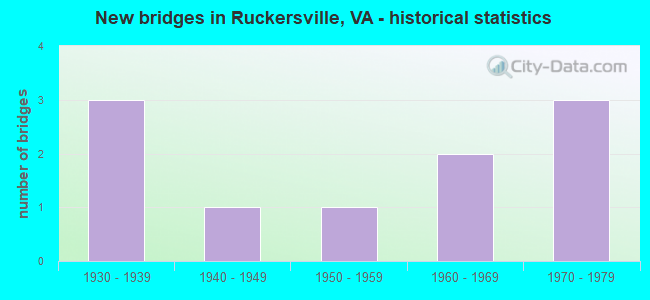
- New bridges - historical statistics
- 31930-1939
- 11940-1949
- 11950-1959
- 21960-1969
- 31970-1979

- Reconstructed bridges - Historical Statistics
- 21990-1999
- 12000-2009
- 12010-2019


- Bridge Condition - Deck
- 37.5%Very good
- 25.0%Good
- 12.5%Satisfactory
- 25.0%Fair

- Bridge Condition - Superstructure
- 25.0%Very good
- 37.5%Good
- 12.5%Satisfactory
- 25.0%Fair

- Bridge Condition - Substructure
- 25.0%Good
- 50.0%Satisfactory
- 25.0%Fair

- Bridge Condition - Channel
- 77.8%Satisfactory
- 11.1%Fair
- 11.1%Poor

- Bridge Condition - Culverts
- 50.0%Satisfactory
- 50.0%Fair
Find on map >> Show street view
Structure Number: 71, Location: 0.85 FR 640 / 0.54 TO 644 (Lat: 38.169897, Lng: -78.355075), Route carried "on" structure: County highway 641, Year Built: 1932, Status: Open, Structure Length: 1.04m (3.41ft), Average Daily Traffic: 992 (year 2015), Average Future Daily Traffic: 1,488 (year 2040), Features Intersected: PREDDY CREEK, Facility Carried by Structure: BURNLEY STATION RD
Minimum Vertical Clearance: 30+ m (98+ ft), Kilometerpoint: 9.944, Lanes on structure: 1, Owner: State Highway Agency, Approaching Roadway Width: 4.9m (16.1ft), Material/Design: Steel, Design/Construction: Stringer/Multi-beam, Number Of Spans In Main Unit: 1, Length of Maximum Span: 10.4m (34.1ft), Curb-To-Curb Width: 3.8m (12.5ft), Out-to-Out Width: 4.9m (16.1ft)
Condition: Deck: Very good, Superstructure: Satisfactory, Substructure: Satisfactory, Channel: Satisfactory, Operating Rating: 41.7 metric tons, Method Used To Determine Operating Rating: Load Factor (LF), Inventory Rating: 24.5 metric tons, Method Used To Determine Inventory Rating: Load Factor (LF), Structural Evaluation: Equal to present minimum criteria, Deck Geometry: High priority of replacement, Waterway Adequacy: Meets minimum limits, Approach Roadway Alignment: High priority of corrective action, Length Of Structure Improvement: 1.52m (4.99ft), Designated Inspection Frequency: Every 24 months, Inspection Date: Febuary 2021, Bridge Improvement Cost: $210,000, Roadway Improvement Cost: $100,000, Total Project Cost: $340,000, Deck Structure Type: Wood or Timber
Find on map >> Show street view
Structure Number: 711, Location: 0.70 FR 644 / 2.19 TO 20 (Lat: 38.169225, Lng: -78.339344), Route carried "on" structure: County highway 641, Year Built: 1932, Year Reconstructed: 2017, Status: Open, Structure Length: 2.88m (9.45ft), Average Daily Traffic: 992 (year 2015), Average Future Daily Traffic: 1,488 (year 2040), Design Load: HS 20, Features Intersected: NORFOLK SOUTHERN RAILWAY, Facility Carried by Structure: BURNLEY STATION RD
Minimum Vertical Clearance: 30+ m (98+ ft), Kilometerpoint: 11.939, Lanes on structure: 1, Owner: State Highway Agency, Approaching Roadway Width: 5.1m (16.7ft), Material/Design: Steel, Design/Construction: Stringer/Multi-beam, Number Of Spans In Main Unit: 3, Length of Maximum Span: 9.6m (31.5ft), Curb or Sidewalk Widths: Left: 0.2m (0.7ft), Right: 0.2m (0.7ft), Curb-To-Curb Width: 4.5m (14.8ft), Out-to-Out Width: 4.9m (16.1ft)
Condition: Deck: Very good, Superstructure: Very good, Substructure: Good, Operating Rating: 75.3 metric tons, Method Used To Determine Operating Rating: Load and Resistance Factor (LRFR), Inventory Rating: 58.1 metric tons, Method Used To Determine Inventory Rating: Load and Resistance Factor (LRFR), Structural Evaluation: Better than present minimum criteria, Deck Geometry: High priority of replacement, Underclear: Meets minimum limits, Approach Roadway Alignment: High priority of corrective action, Length Of Structure Improvement: 3.05m (10.01ft), Designated Inspection Frequency: Every 12 months, Critical Feature Inspection Frequency: Every 12 months, Inspection Date: April 2021, Critical Feature Inspection Date: April 2021, Bridge Improvement Cost: $300,000, Roadway Improvement Cost: $60,000, Total Project Cost: $390,000, Deck Structure Type: Wood or Timber
Find on map >> Show street view
Structure Number: 5704, Location: .25 From 646 & .85 To 627 (Lat: 38.597933, Lng: -78.061594), Route carried "on" structure: County highway 729, Year Built: 1959, Status: Open, Structure Length: 5.94m (19.49ft), Average Daily Traffic: 1,234 (year 2020), Truck Traffic: 2%, Average Future Daily Traffic: 1,383 (year 2040), Design Load: HS 20, Features Intersected: Hazel River, Facility Carried by Structure: Eggbornsville Road
Minimum Vertical Clearance: 30+ m (98+ ft), Kilometerpoint: 15.076, Lanes on structure: 2, Owner: State Highway Agency, Approaching Roadway Width: 6.1m (20.0ft), Material/Design: Steel, Design/Construction: Stringer/Multi-beam, Number Of Spans In Main Unit: 3, Length of Maximum Span: 20.7m (67.9ft), Curb or Sidewalk Widths: Left: 0.5m (1.6ft), Right: 0.5m (1.6ft), Curb-To-Curb Width: 7.3m (24.0ft), Out-to-Out Width: 8.2m (26.9ft)
Condition: Deck: Fair, Superstructure: Fair, Substructure: Fair, Channel: Poor, Operating Rating: 49.0 metric tons, Method Used To Determine Operating Rating: Load and Resistance Factor (LRFR), Inventory Rating: 37.2 metric tons, Method Used To Determine Inventory Rating: Load and Resistance Factor (LRFR), Structural Evaluation: Somewhat better than minimum adequacy, Deck Geometry: Meets minimum limits, Waterway Adequacy: Better than present minimum criteria, Approach Roadway Alignment: Equal to present minimum criteria, Designated Inspection Frequency: Every 24 months, Inspection Date: October 2021, Deck Structure Type: Concrete Cast-file-Place, Wearing Surface/Protective System: Wearing Surface: Latex Concrete
Find on map >> Show street view
Structure Number: 8958, Location: .13 From 645 & .16 To 609 (Lat: 38.271819, Lng: -78.351175), Route carried "on" structure: US 29, Year Built: 1966, Status: Open, Structure Length: 0.94m (3.08ft), Average Daily Traffic: 14,888 (year 2020), Truck Traffic: 6%, Average Future Daily Traffic: 19,606 (year 2040), Design Load: HS 20, Features Intersected: White Run, Facility Carried by Structure: Seminole Trail
Minimum Vertical Clearance: 30+ m (98+ ft), Kilometerpoint: 249.701, Lanes on structure: 4, Base Highway Network: Yes, Owner: State Highway Agency, Approaching Roadway Width: 14.6m (47.9ft), Material/Design: Concrete, Design/Construction: Culvert, Number Of Spans In Main Unit: 3, Length of Maximum Span: 3.4m (11.2ft)
Condition: Channel: Satisfactory, Culverts: Satisfactory, Operating Rating: 89.8 metric tons, Method Used To Determine Operating Rating: Load Factor (LF), Inventory Rating: 89.8 metric tons, Method Used To Determine Inventory Rating: Load Factor (LF), Structural Evaluation: Equal to present minimum criteria, Waterway Adequacy: Equal to present minimum criteria, Approach Roadway Alignment: Equal to present desirable criteria, Designated Inspection Frequency: Every 24 months, Inspection Date: May 2021
Find on map >> Show street view
Structure Number: 8963, Location: Greene/Madison Line (Lat: 38.279675, Lng: -78.341742), Route carried "on" structure: US 29, Year Built: 1967, Status: Open, Structure Length: 10.73m (35.20ft), Average Daily Traffic: 7,444 (year 2020), Truck Traffic: 6%, Average Future Daily Traffic: 10,422 (year 2040), Design Load: HS 20+Mod, Features Intersected: Rapidan River, Facility Carried by Structure: Seminole Trail SBL
Minimum Vertical Clearance: 30+ m (98+ ft), Kilometerpoint: 250.924, Lanes on structure: 1, Base Highway Network: Yes, Owner: State Highway Agency, Approaching Roadway Width: 7.3m (24.0ft), Material/Design: Prestressed concrete, Design/Construction: Stringer/Multi-beam, Number Of Spans In Main Unit: 6, Length of Maximum Span: 24.4m (80.1ft), Curb or Sidewalk Widths: Left: 0.2m (0.7ft), Right: 0.2m (0.7ft), Curb-To-Curb Width: 10.0m (32.8ft), Out-to-Out Width: 10.9m (35.8ft)
Condition: Deck: Fair, Superstructure: Fair, Substructure: Fair, Channel: Satisfactory, Operating Rating: 77.1 metric tons, Method Used To Determine Operating Rating: Load and Resistance Factor (LRFR), Inventory Rating: 49.9 metric tons, Method Used To Determine Inventory Rating: Load and Resistance Factor (LRFR), Structural Evaluation: Somewhat better than minimum adequacy, Deck Geometry: Meets minimum limits, Waterway Adequacy: Equal to present minimum criteria, Approach Roadway Alignment: Equal to present minimum criteria, Designated Inspection Frequency: Every 24 months, Inspection Date: June 2021, Deck Structure Type: Concrete Cast-file-Place, Wearing Surface/Protective System: Wearing Surface: Latex Concrete
Find on map >> Show street view
Structure Number: 8964, Location: Greene/Madison Line (Lat: 38.279572, Lng: -78.341556), Route carried "on" structure: US 29, Year Built: 1974, Status: Open, Structure Length: 10.76m (35.30ft), Average Daily Traffic: 7,444 (year 2020), Truck Traffic: 6%, Average Future Daily Traffic: 10,422 (year 2040), Design Load: HS 20+Mod, Features Intersected: Rapidan River, Facility Carried by Structure: NBL Seminole Trail
Minimum Vertical Clearance: 30+ m (98+ ft), Kilometerpoint: 250.924, Lanes on structure: 2, Base Highway Network: Yes, Owner: State Highway Agency, Approaching Roadway Width: 7.3m (24.0ft), Material/Design: Steel, Design/Construction: Stringer/Multi-beam, Number Of Spans In Main Unit: 6, Length of Maximum Span: 25.0m (82.0ft), Curb-To-Curb Width: 11.0m (36.1ft), Out-to-Out Width: 12.2m (40.0ft)
Condition: Deck: Satisfactory, Superstructure: Good, Substructure: Good, Channel: Satisfactory, Operating Rating: 62.6 metric tons, Method Used To Determine Operating Rating: Load and Resistance Factor (LRFR), Inventory Rating: 48.1 metric tons, Method Used To Determine Inventory Rating: Load and Resistance Factor (LRFR), Structural Evaluation: Better than present minimum criteria, Deck Geometry: Equal to present minimum criteria, Waterway Adequacy: Equal to present desirable criteria, Approach Roadway Alignment: Equal to present desirable criteria, Designated Inspection Frequency: Every 24 months, Inspection Date: October 2021, Deck Structure Type: Concrete Cast-file-Place, Wearing Surface/Protective System: Wearing Surface: Latex Concrete
Find on map >> Show street view
Structure Number: 8977, Location: .02 From 616&.67 OrangeCo (Lat: 38.207844, Lng: -78.360431), Route carried "on" structure: County highway 607, Year Built: 1976, Year Reconstructed: 2004, Status: Open, Structure Length: 1.13m (3.71ft), Average Daily Traffic: 3,042 (year 2020), Truck Traffic: 2%, Average Future Daily Traffic: 4,176 (year 2040), Design Load: HS 20+Mod, Features Intersected: Preddy Creek, Facility Carried by Structure: Matthew Mill Road
Minimum Vertical Clearance: 30+ m (98+ ft), Kilometerpoint: 4.698, Lanes on structure: 2, Owner: State Highway Agency, Approaching Roadway Width: 6.7m (22.0ft), Skew: 1 degrees, Material/Design: Prestressed concrete, Design/Construction: Slab, Number Of Spans In Main Unit: 1, Length of Maximum Span: 11.3m (37.1ft), Curb-To-Curb Width: 7.8m (25.6ft), Out-to-Out Width: 7.9m (25.9ft)
Condition: Deck: Good, Superstructure: Good, Substructure: Satisfactory, Channel: Satisfactory, Operating Rating: 78.7 metric tons, Method Used To Determine Operating Rating: Load Factor (LF), Inventory Rating: 47.2 metric tons, Method Used To Determine Inventory Rating: Load Factor (LF), Structural Evaluation: Equal to present minimum criteria, Deck Geometry: High priority of replacement, Waterway Adequacy: Equal to present minimum criteria, Approach Roadway Alignment: Equal to present minimum criteria, Length Of Structure Improvement: 1.13m (3.71ft), Designated Inspection Frequency: Every 24 months, Inspection Date: July 2020, Bridge Improvement Cost: $250,000, Roadway Improvement Cost: $50,000, Total Project Cost: $325,000, Deck Structure Type: Other, Wearing Surface/Protective System: Wearing Surface: Bituminous
Find on map >> Show street view
Structure Number: 8978, Location: 2.00 From 29 & .94 To 610 (Lat: 38.266278, Lng: -78.318639), Route carried "on" structure: County highway 609, Year Built: 1949, Year Reconstructed: 1997, Status: Open, Structure Length: 2.32m (7.61ft), Average Daily Traffic: 556 (year 2020), Truck Traffic: 3%, Average Future Daily Traffic: 778 (year 2040), Design Load: H 15, Features Intersected: Rippin Run, Facility Carried by Structure: Fredericksburg Rd
Minimum Vertical Clearance: 30+ m (98+ ft), Kilometerpoint: 9.654, Lanes on structure: 2, Owner: State Highway Agency, Approaching Roadway Width: 6.1m (20.0ft), Material/Design: Steel, Design/Construction: Stringer/Multi-beam, Number Of Spans In Main Unit: 1, Length of Maximum Span: 23.2m (76.1ft), Curb-To-Curb Width: 8.3m (27.2ft), Out-to-Out Width: 9.0m (29.5ft)
Condition: Deck: Good, Superstructure: Good, Substructure: Satisfactory, Channel: Satisfactory, Operating Rating: 59.9 metric tons, Method Used To Determine Operating Rating: Load and Resistance Factor (LRFR), Inventory Rating: 45.4 metric tons, Method Used To Determine Inventory Rating: Load and Resistance Factor (LRFR), Structural Evaluation: Equal to present minimum criteria, Deck Geometry: Somewhat better than minimum adequacy, Waterway Adequacy: Equal to present minimum criteria, Approach Roadway Alignment: Equal to present minimum criteria, Designated Inspection Frequency: Every 24 months, Inspection Date: November 2021, Deck Structure Type: Concrete Cast-file-Place, Wearing Surface/Protective System: Deck Protection: Epoxy Coated Reinforcing
Find on map >> Show street view
Structure Number: 8981, Location: .65 From 609 &3.50 To 230 (Lat: 38.291578, Lng: -78.372728), Route carried "on" structure: County highway 619, Year Built: 1932, Year Reconstructed: 2012, Status: Open, Structure Length: 2.01m (6.59ft), Average Daily Traffic: 401 (year 2020), Average Future Daily Traffic: 561 (year 2040), Design Load: HS 20+Mod, Features Intersected: South River, Facility Carried by Structure: Dundee Road
Minimum Vertical Clearance: 30+ m (98+ ft), Kilometerpoint: 1.046, Lanes on structure: 2, Owner: State Highway Agency, Approaching Roadway Width: 6.1m (20.0ft), Skew: 3 degrees, Material/Design: Prestressed concrete, Design/Construction: Slab, Number Of Spans In Main Unit: 1, Length of Maximum Span: 20.1m (65.9ft), Curb-To-Curb Width: 5.9m (19.4ft), Out-to-Out Width: 6.1m (20.0ft)
Condition: Deck: Very good, Superstructure: Very good, Substructure: Satisfactory, Channel: Satisfactory, Operating Rating: 77.1 metric tons, Method Used To Determine Operating Rating: Load and Resistance Factor (LRFR), Inventory Rating: 59.9 metric tons, Method Used To Determine Inventory Rating: Load and Resistance Factor (LRFR), Structural Evaluation: Equal to present minimum criteria, Deck Geometry: High priority of replacement, Waterway Adequacy: Somewhat better than minimum adequacy, Approach Roadway Alignment: High priority of corrective action, Length Of Structure Improvement: 2.01m (6.59ft), Designated Inspection Frequency: Every 24 months, Inspection Date: March 2020, Bridge Improvement Cost: $150,000, Roadway Improvement Cost: $50,000, Total Project Cost: $215,000, Deck Structure Type: Other, Wearing Surface/Protective System: Wearing Surface: Bituminous, Membrane: Epoxy, Deck Protection: Galvanized Reinforcing
Find on map >> Show street view
Structure Number: 13029, Location: .28 From 644 & .63 To 618 (Lat: 38.219119, Lng: -78.311708), Route carried "on" structure: County highway 657, Year Built: 1973, Status: Open, Structure Length: 0.67m (2.20ft), Average Daily Traffic: 314 (year 2017), Average Future Daily Traffic: 350 (year 2040), Design Load: HS 20, Features Intersected: Colvin Creek, Facility Carried by Structure: Albano Road
Minimum Vertical Clearance: 30+ m (98+ ft), Kilometerpoint: 3.266, Lanes on structure: 2, Owner: State Highway Agency, Approaching Roadway Width: 4.9m (16.1ft), Skew: 1 degrees, Material/Design: Steel, Design/Construction: Culvert, Number Of Spans In Main Unit: 2, Length of Maximum Span: 3.4m (11.2ft)
Condition: Channel: Fair, Culverts: Fair, Operating Rating: 44.5 metric tons, Method Used To Determine Operating Rating: Field evaluation and documented engineering judgment, Inventory Rating: 32.7 metric tons, Method Used To Determine Inventory Rating: Field evaluation and documented engineering judgment, Structural Evaluation: Somewhat better than minimum adequacy, Waterway Adequacy: Equal to present minimum criteria, Approach Roadway Alignment: Better than present minimum criteria, Designated Inspection Frequency: Every 24 months, Inspection Date: Febuary 2022