Bridge Statistics for Runnells, Iowa (IA)
Condition, Traffic, Stress, Structural Evaluation, Project Costs
- National Bridge Inventory (NBI) Statistics
- 12Number of bridges
- 131ft / 40.1mTotal length
- 2,565Total average daily traffic
- 121Total average daily truck traffic
- 2,565Total future (year 2040) average daily traffic
- National Bridge Inventory (NBI) Registered Bridges for Runnells
- No street view available for this location
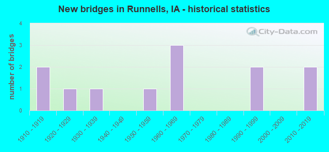
- New bridges - historical statistics
- 21910-1919
- 11920-1929
- 11930-1939
- 11950-1959
- 31960-1969
- 21990-1999
- 22010-2019

- Bridge Condition - Deck
- 25.0%Very good
- 8.3%Good
- 25.0%Satisfactory
- 8.3%Fair
- 25.0%Poor
- 8.3%Serious

- Bridge Condition - Superstructure
- 33.3%Very good
- 8.3%Good
- 8.3%Satisfactory
- 8.3%Fair
- 33.3%Poor
- 8.3%Serious

- Bridge Condition - Substructure
- 25.0%Very good
- 16.7%Good
- 16.7%Satisfactory
- 8.3%Fair
- 33.3%Poor

- Bridge Condition - Channel
- 8.3%Very good
- 25.0%Good
- 25.0%Satisfactory
- 25.0%Fair
- 16.7%Poor
Find on map >> Show street view
Structure Number: 19612, Location: 078213101 (Lat: 41.522275, Lng: -93.326542), Route carried "on" structure: County highway , Year Built: 1965, Status: Open, Structure Length: 7.71m (25.30ft), Average Daily Traffic: 680 (year 2018), Truck Traffic: 7%, Average Future Daily Traffic: 680 (year 2041), Design Load: H 20, Features Intersected: CAMP CREEK, Facility Carried by Structure: HIGHWAY F-70 W
Minimum Vertical Clearance: 30+ m (98+ ft), Kilometerpoint: 0.185, Lanes on structure: 2, Owner: County Highway Agency, Approaching Roadway Width: 11.6m (38.1ft), Skew: 3 degrees, Material/Design: Steel continuous, Design/Construction: Stringer/Multi-beam, Number Of Spans In Main Unit: 3, Length of Maximum Span: 29.9m (98.1ft), Curb-To-Curb Width: 8.6m (28.2ft), Out-to-Out Width: 9.2m (30.2ft)
Condition: Deck: Poor, Superstructure: Poor, Substructure: Poor, Channel: Satisfactory, Operating Rating: 39.5 metric tons, Method Used To Determine Operating Rating: Load Factor (LF), Inventory Rating: 23.7 metric tons, Method Used To Determine Inventory Rating: Load Factor (LF), Structural Evaluation: Meets minimum limits, Deck Geometry: Somewhat better than minimum adequacy, Waterway Adequacy: Equal to present minimum criteria, Approach Roadway Alignment: Better than present minimum criteria, Length Of Structure Improvement: 28.00m (91.86ft), Designated Inspection Frequency: Every 24 months, Inspection Date: April 2021, Bridge Improvement Cost: $650,000, Roadway Improvement Cost: $75,000, Deck Structure Type: Concrete Cast-file-Place, Wearing Surface/Protective System: Wearing Surface: Monolithic Concrete
Find on map >> Show street view
Structure Number: 28055, Location: 077220201 (Lat: 41.507378, Lng: -93.367164), Route carried "on" structure: County highway , Year Built: 1920, Status: Posted for load, Structure Length: 4.66m (15.29ft), Average Daily Traffic: 50 (year 2016), Truck Traffic: 8%, Average Future Daily Traffic: 50 (year 2041), Design Load: H 15, Features Intersected: MUD CREEK, Facility Carried by Structure: LOCAL
Minimum Vertical Clearance: 30+ m (98+ ft), Kilometerpoint: 1.080, Lanes on structure: 2, Owner: County Highway Agency, Approaching Roadway Width: 7.3m (24.0ft), Material/Design: Steel, Design/Construction: Truss - Thru, Number Of Spans In Main Unit: 1, Number Of Approach Spans: 2, Length of Maximum Span: 24.4m (80.1ft), Curb-To-Curb Width: 5.8m (19.0ft), Out-to-Out Width: 6.1m (20.0ft)
Condition: Deck: Poor, Superstructure: Fair, Substructure: Fair, Channel: Poor, Operating Rating: 29.8 metric tons, Method Used To Determine Operating Rating: Allowable Stress (AS), Inventory Rating: 19.2 metric tons, Method Used To Determine Inventory Rating: Allowable Stress (AS), Structural Evaluation: Somewhat better than minimum adequacy, Deck Geometry: Meets minimum limits, Waterway Adequacy: Meets minimum limits, Approach Roadway Alignment: Better than present minimum criteria, Bridge Posting: Required (Relationship of Operating Rating to Maximum Legal Load: 0.1 - 9.9% below), Length Of Structure Improvement: 18.00m (59.06ft), Designated Inspection Frequency: Every 24 months, Critical Feature Inspection Frequency: Every 24 months, Inspection Date: Febuary 2021, Critical Feature Inspection Date: Febuary 2021, Bridge Improvement Cost: $395,000, Roadway Improvement Cost: $39,000, Deck Structure Type: Concrete Cast-file-Place, Wearing Surface/Protective System: Wearing Surface: Monolithic Concrete
Find on map >> Show street view
Structure Number: 28066, Location: 078221403 (Lat: 41.565447, Lng: -93.349958), Route carried "on" structure: County highway , Year Built: 1914, Status: Posted for load, Structure Length: 1.62m (5.31ft), Average Daily Traffic: 25 (year 2016), Average Future Daily Traffic: 25 (year 2041), Features Intersected: CAMP CREEK, Facility Carried by Structure: LOCAL ROAD
Minimum Vertical Clearance: 30+ m (98+ ft), Kilometerpoint: 2.511, Lanes on structure: 2, Owner: County Highway Agency, Approaching Roadway Width: 7.3m (24.0ft), Material/Design: Steel, Design/Construction: Truss - Thru, Number Of Spans In Main Unit: 1, Length of Maximum Span: 15.2m (49.9ft), Curb-To-Curb Width: 5.2m (17.1ft), Out-to-Out Width: 5.5m (18.0ft)
Condition: Deck: Fair, Superstructure: Poor, Substructure: Poor, Channel: Poor, Operating Rating: 21.9 metric tons, Method Used To Determine Operating Rating: Allowable Stress (AS), Inventory Rating: 14.1 metric tons, Method Used To Determine Inventory Rating: Allowable Stress (AS), Structural Evaluation: Meets minimum limits, Deck Geometry: High priority of corrective action, Waterway Adequacy: Equal to present minimum criteria, Approach Roadway Alignment: Meets minimum limits, Bridge Posting: Required (Relationship of Operating Rating to Maximum Legal Load: 0.1 - 9.9% below), Length Of Structure Improvement: 7.60m (24.93ft), Designated Inspection Frequency: Every 24 months, Critical Feature Inspection Frequency: Every 24 months, Inspection Date: September 2021, Critical Feature Inspection Date: September 2021, Bridge Improvement Cost: $125,000, Roadway Improvement Cost: $15,000, Deck Structure Type: Concrete Cast-file-Place, Wearing Surface/Protective System: Wearing Surface: Gravel
Find on map >> Show street view
Structure Number: 280671, Location: 078221603 (Lat: 41.565292, Lng: -93.390756), Route carried "on" structure: County highway , Year Built: 2013, Status: Open, Structure Length: 4.61m (15.12ft), Average Daily Traffic: 60 (year 2016), Average Future Daily Traffic: 60 (year 2040), Design Load: HL 93, Features Intersected: BRANCH MUD CREEK, Facility Carried by Structure: SE 20TH AVE
Minimum Vertical Clearance: 30+ m (98+ ft), Kilometerpoint: 2.111, Lanes on structure: 2, Owner: County Highway Agency, Approaching Roadway Width: 11.0m (36.1ft), Skew: 1 degrees, Material/Design: Prestressed concrete, Design/Construction: Stringer/Multi-beam, Number Of Spans In Main Unit: 3, Length of Maximum Span: 16.8m (55.1ft), Curb-To-Curb Width: 9.1m (29.9ft), Out-to-Out Width: 10.1m (33.1ft)
Condition: Deck: Very good, Superstructure: Very good, Substructure: Very good, Channel: Very good, Operating Rating: 49.6 metric tons, Method Used To Determine Operating Rating: Load and Resistance Factor Rating (LRFR) rating reported by rating factor(RF) method using HL-93 loadings, Inventory Rating: 36.0 metric tons, Method Used To Determine Inventory Rating: Load and Resistance Factor Rating (LRFR) rating reported by rating factor(RF) method using HL-93 loadings, Structural Evaluation: Equal to present desirable criteria, Deck Geometry: Better than present minimum criteria, Waterway Adequacy: Equal to present desirable criteria, Approach Roadway Alignment: Equal to present desirable criteria, Designated Inspection Frequency: Every 24 months, Inspection Date: June 2020, Deck Structure Type: Concrete Cast-file-Place, Wearing Surface/Protective System: Wearing Surface: Monolithic Concrete
Find on map >> Show street view
Structure Number: 280701, Location: 078222201 (Lat: 41.550814, Lng: -93.386772), Route carried "on" structure: County highway , Year Built: 1990, Status: Open, Structure Length: 4.60m (15.09ft), Average Daily Traffic: 360 (year 2016), Average Future Daily Traffic: 360 (year 2041), Design Load: HS 20, Features Intersected: MUD CREEK, Facility Carried by Structure: FM
Minimum Vertical Clearance: 30+ m (98+ ft), Kilometerpoint: 7.849, Lanes on structure: 2, Owner: County Highway Agency, Approaching Roadway Width: 10.4m (34.1ft), Material/Design: Prestressed concrete, Design/Construction: Stringer/Multi-beam, Number Of Spans In Main Unit: 3, Length of Maximum Span: 17.4m (57.1ft), Curb-To-Curb Width: 9.1m (29.9ft), Out-to-Out Width: 10.1m (33.1ft)
Condition: Deck: Good, Superstructure: Very good, Substructure: Good, Channel: Good, Operating Rating: 74.1 metric tons, Method Used To Determine Operating Rating: Load Factor (LF), Inventory Rating: 35.6 metric tons, Method Used To Determine Inventory Rating: Load Factor (LF), Structural Evaluation: Better than present minimum criteria, Deck Geometry: Equal to present minimum criteria, Waterway Adequacy: Equal to present desirable criteria, Approach Roadway Alignment: Equal to present desirable criteria, Length Of Structure Improvement: 15.10m (49.54ft), Designated Inspection Frequency: Every 24 months, Inspection Date: September 2021, Bridge Improvement Cost: $80,000, Roadway Improvement Cost: $20,000, Deck Structure Type: Concrete Cast-file-Place, Wearing Surface/Protective System: Wearing Surface: Monolithic Concrete
Find on map >> Show street view
Structure Number: 280711, Location: 078222403 (Lat: 41.547611, Lng: -93.339864), Route carried "on" structure: County highway , Year Built: 1993, Status: Open, Structure Length: 4.88m (16.01ft), Average Daily Traffic: 150 (year 2016), Truck Traffic: 15%, Average Future Daily Traffic: 150 (year 2041), Design Load: HS 20, Features Intersected: CAMP CREEK, Facility Carried by Structure: FM
Minimum Vertical Clearance: 30+ m (98+ ft), Kilometerpoint: 1.854, Lanes on structure: 2, Owner: County Highway Agency, Approaching Roadway Width: 10.4m (34.1ft), Material/Design: Concrete continuous, Design/Construction: Slab, Number Of Spans In Main Unit: 4, Length of Maximum Span: 13.4m (44.0ft), Curb-To-Curb Width: 9.1m (29.9ft), Out-to-Out Width: 10.1m (33.1ft)
Condition: Deck: Very good, Superstructure: Very good, Substructure: Very good, Channel: Good, Operating Rating: 60.6 metric tons, Method Used To Determine Operating Rating: Load and Resistance Factor Rating (LRFR) rating reported by rating factor(RF) method using HL-93 loadings, Inventory Rating: 46.7 metric tons, Method Used To Determine Inventory Rating: Load and Resistance Factor Rating (LRFR) rating reported by rating factor(RF) method using HL-93 loadings, Structural Evaluation: Equal to present desirable criteria, Deck Geometry: Equal to present minimum criteria, Waterway Adequacy: Equal to present desirable criteria, Approach Roadway Alignment: Equal to present minimum criteria, Designated Inspection Frequency: Every 24 months, Inspection Date: Febuary 2021, Deck Structure Type: Concrete Cast-file-Place, Wearing Surface/Protective System: Wearing Surface: Monolithic Concrete
Find on map >> Show street view
Structure Number: 28072, Location: 078222404 (Lat: 41.548919, Lng: -93.338664), Route carried "on" structure: County highway , Year Built: 1954, Status: Open, Structure Length: 0.98m (3.22ft), Average Daily Traffic: 70 (year 2016), Average Future Daily Traffic: 70 (year 2040), Design Load: HL 93, Features Intersected: CAMP CREEK, Facility Carried by Structure: FM S.E.124TH
Minimum Vertical Clearance: 30+ m (98+ ft), Kilometerpoint: 2.486, Lanes on structure: 2, Owner: County Highway Agency, Approaching Roadway Width: 8.5m (27.9ft), Material/Design: Steel, Design/Construction: Stringer/Multi-beam, Number Of Spans In Main Unit: 1, Length of Maximum Span: 9.1m (29.9ft), Curb-To-Curb Width: 6.2m (20.3ft), Out-to-Out Width: 6.7m (22.0ft)
Condition: Deck: Satisfactory, Superstructure: Satisfactory, Substructure: Satisfactory, Channel: Fair, Operating Rating: 23.7 metric tons, Method Used To Determine Operating Rating: Load and Resistance Factor Rating (LRFR) rating reported by rating factor(RF) method using HL-93 loadings, Inventory Rating: 18.1 metric tons, Method Used To Determine Inventory Rating: Load and Resistance Factor Rating (LRFR) rating reported by rating factor(RF) method using HL-93 loadings, Structural Evaluation: Somewhat better than minimum adequacy, Deck Geometry: Somewhat better than minimum adequacy, Waterway Adequacy: Equal to present minimum criteria, Approach Roadway Alignment: Better than present minimum criteria, Length Of Structure Improvement: 5.30m (17.39ft), Designated Inspection Frequency: Every 24 months, Inspection Date: December 2020, Bridge Improvement Cost: $160,000, Roadway Improvement Cost: $30,000, Deck Structure Type: Concrete Cast-file-Place, Wearing Surface/Protective System: Wearing Surface: Gravel
Find on map >> Show street view
Structure Number: 28073, Location: 078222408 (Lat: 41.538761, Lng: -93.338622), Route carried "on" structure: County highway , Year Built: 1930, Year Reconstructed: 1958, Status: Open, Structure Length: 2.53m (8.30ft), Average Daily Traffic: 80 (year 2016), Average Future Daily Traffic: 80 (year 2041), Design Load: HS 20, Features Intersected: CAMP CREEK, Facility Carried by Structure: LOCAL
Minimum Vertical Clearance: 30+ m (98+ ft), Kilometerpoint: 1.358, Lanes on structure: 2, Owner: County Highway Agency, Approaching Roadway Width: 8.2m (26.9ft), Material/Design: Steel, Design/Construction: Truss - Thru, Number Of Spans In Main Unit: 1, Number Of Approach Spans: 1, Length of Maximum Span: 18.3m (60.0ft), Curb or Sidewalk Widths: Left: 0.3m (1.0ft), Right: 0.3m (1.0ft), Curb-To-Curb Width: 6.1m (20.0ft), Out-to-Out Width: 6.7m (22.0ft)
Condition: Deck: Satisfactory, Superstructure: Poor, Substructure: Satisfactory, Channel: Fair, Operating Rating: 36.4 metric tons, Method Used To Determine Operating Rating: Allowable Stress (AS), Inventory Rating: 23.2 metric tons, Method Used To Determine Inventory Rating: Allowable Stress (AS), Structural Evaluation: Meets minimum limits, Deck Geometry: Somewhat better than minimum adequacy, Waterway Adequacy: Equal to present minimum criteria, Approach Roadway Alignment: Equal to present minimum criteria, Length Of Structure Improvement: 10.80m (35.43ft), Designated Inspection Frequency: Every 24 months, Critical Feature Inspection Frequency: Every 24 months, Inspection Date: September 2021, Critical Feature Inspection Date: September 2021, Bridge Improvement Cost: $155,000, Roadway Improvement Cost: $25,000, Deck Structure Type: Concrete Cast-file-Place, Wearing Surface/Protective System: Wearing Surface: Monolithic Concrete
Find on map >> Show street view
Structure Number: 28076, Location: 078222705 (Lat: 41.529069, Lng: -93.377003), Route carried "on" structure: County highway , Year Built: 1968, Status: Open, Structure Length: 5.33m (17.49ft), Average Daily Traffic: 800 (year 2016), Truck Traffic: 6%, Average Future Daily Traffic: 800 (year 2041), Design Load: H 20, Features Intersected: MUD CREEK, Facility Carried by Structure: FM
Minimum Vertical Clearance: 30+ m (98+ ft), Kilometerpoint: 3.706, Lanes on structure: 2, Owner: County Highway Agency, Approaching Roadway Width: 10.4m (34.1ft), Material/Design: Steel continuous, Design/Construction: Stringer/Multi-beam, Number Of Spans In Main Unit: 3, Length of Maximum Span: 21.0m (68.9ft), Curb-To-Curb Width: 8.6m (28.2ft), Out-to-Out Width: 9.2m (30.2ft)
Condition: Deck: Satisfactory, Superstructure: Good, Substructure: Good, Channel: Satisfactory, Operating Rating: 36.9 metric tons, Method Used To Determine Operating Rating: Load and Resistance Factor Rating (LRFR) rating reported by rating factor(RF) method using HL-93 loadings, Inventory Rating: 28.5 metric tons, Method Used To Determine Inventory Rating: Load and Resistance Factor Rating (LRFR) rating reported by rating factor(RF) method using HL-93 loadings, Structural Evaluation: Better than present minimum criteria, Deck Geometry: Somewhat better than minimum adequacy, Waterway Adequacy: Better than present minimum criteria, Approach Roadway Alignment: Equal to present minimum criteria, Length Of Structure Improvement: 20.00m (65.62ft), Designated Inspection Frequency: Every 24 months, Inspection Date: June 2021, Bridge Improvement Cost: $365,000, Roadway Improvement Cost: $40,000, Deck Structure Type: Concrete Cast-file-Place, Wearing Surface/Protective System: Wearing Surface: Monolithic Concrete
Find on map >> Show street view
Structure Number: 28077, Location: 078222706 (Lat: 41.524453, Lng: -93.373628), Route carried "on" structure: County highway , Year Built: 1913, Status: Posted for load, Structure Length: 1.19m (3.90ft), Average Daily Traffic: 80 (year 2016), Average Future Daily Traffic: 80 (year 2041), Features Intersected: MUD CREEK, Facility Carried by Structure: LOCAL ROAD
Minimum Vertical Clearance: 30+ m (98+ ft), Kilometerpoint: 0.550, Lanes on structure: 2, Owner: County Highway Agency, Approaching Roadway Width: 7.3m (24.0ft), Material/Design: Concrete, Design/Construction: Slab, Number Of Spans In Main Unit: 1, Length of Maximum Span: 11.0m (36.1ft), Curb-To-Curb Width: 5.2m (17.1ft), Out-to-Out Width: 6.1m (20.0ft)
Condition: Deck: Serious, Superstructure: Serious, Substructure: Poor, Channel: Fair, Operating Rating: 16.5 metric tons, Method Used To Determine Operating Rating: Load and Resistance Factor Rating (LRFR) rating reported by rating factor(RF) method using HL-93 loadings, Inventory Rating: 12.6 metric tons, Method Used To Determine Inventory Rating: Load and Resistance Factor Rating (LRFR) rating reported by rating factor(RF) method using HL-93 loadings, Structural Evaluation: High priority of corrective action, Deck Geometry: High priority of corrective action, Waterway Adequacy: Equal to present minimum criteria, Approach Roadway Alignment: Somewhat better than minimum adequacy, Bridge Posting: Required (Relationship of Operating Rating to Maximum Legal Load: 20.0 - 29.9% below), Length Of Structure Improvement: 6.00m (19.69ft), Designated Inspection Frequency: Every 12 months, Inspection Date: June 2021, Bridge Improvement Cost: $133,000, Roadway Improvement Cost: $13,000, Deck Structure Type: Concrete Cast-file-Place, Wearing Surface/Protective System: Wearing Surface: Gravel
Find on map >> Show street view
Structure Number: 28078, Location: 078222801 (Lat: 41.536317, Lng: -93.405567), Route carried "on" structure: County highway , Year Built: 1962, Status: Posted for load, Structure Length: 0.76m (2.49ft), Average Daily Traffic: 160 (year 2016), Average Future Daily Traffic: 160 (year 2041), Design Load: H 15, Features Intersected: CREEK, Facility Carried by Structure: LOCAL ROAD
Minimum Vertical Clearance: 30+ m (98+ ft), Kilometerpoint: 2.121, Lanes on structure: 2, Owner: County Highway Agency, Approaching Roadway Width: 8.5m (27.9ft), Material/Design: Concrete, Design/Construction: Stringer/Multi-beam, Number Of Spans In Main Unit: 1, Length of Maximum Span: 7.3m (24.0ft), Curb or Sidewalk Widths: Left: 0.3m (1.0ft), Right: 0.3m (1.0ft), Curb-To-Curb Width: 7.3m (24.0ft), Out-to-Out Width: 8.0m (26.2ft)
Condition: Deck: Poor, Superstructure: Poor, Substructure: Poor, Channel: Satisfactory, Operating Rating: 38.8 metric tons, Method Used To Determine Operating Rating: Allowable Stress (AS), Inventory Rating: 23.2 metric tons, Method Used To Determine Inventory Rating: Allowable Stress (AS), Structural Evaluation: Meets minimum limits, Deck Geometry: Somewhat better than minimum adequacy, Waterway Adequacy: Equal to present minimum criteria, Approach Roadway Alignment: Equal to present minimum criteria, Bridge Posting: Required (Relationship of Operating Rating to Maximum Legal Load: 0.1 - 9.9% below), Length Of Structure Improvement: 4.60m (15.09ft), Designated Inspection Frequency: Every 24 months, Inspection Date: September 2021, Bridge Improvement Cost: $145,000, Roadway Improvement Cost: $17,000, Deck Structure Type: Concrete Precast Panels, Wearing Surface/Protective System: Wearing Surface: Monolithic Concrete
Find on map >> Show street view
Structure Number: 366445, Location: 078212007 (Lat: 41.539911, Lng: -93.302036), Route carried "on" structure: County highway , Year Built: 2018, Status: Open, Structure Length: 1.25m (4.10ft), Average Daily Traffic: 50 (year 2014), Average Future Daily Traffic: 50 (year 2041), Features Intersected: PLEASANT RUN, Facility Carried by Structure: PINION AVE
Minimum Vertical Clearance: 30+ m (98+ ft), Kilometerpoint: 0.769, Lanes on structure: 2, Owner: County Highway Agency, Approaching Roadway Width: 5.5m (18.0ft), Material/Design: Steel, Design/Construction: Slab, Number Of Spans In Main Unit: 1, Length of Maximum Span: 11.9m (39.0ft), Curb-To-Curb Width: 7.5m (24.6ft), Out-to-Out Width: 7.6m (24.9ft)
Condition: Deck: Very good, Superstructure: Very good, Substructure: Very good, Channel: Good, Operating Rating: 66.2 metric tons, Method Used To Determine Operating Rating: Load Factor (LF), Inventory Rating: 39.6 metric tons, Method Used To Determine Inventory Rating: Load Factor (LF), Structural Evaluation: Equal to present desirable criteria, Deck Geometry: Equal to present minimum criteria, Waterway Adequacy: Better than present minimum criteria, Approach Roadway Alignment: Somewhat better than minimum adequacy, Designated Inspection Frequency: Every 48 months, Inspection Date: April 2021, Deck Structure Type: Concrete Cast-file-Place, Wearing Surface/Protective System: Wearing Surface: Monolithic Concrete