Bridge Statistics for Rush, New York (NY)
Condition, Traffic, Stress, Structural Evaluation, Project Costs
- National Bridge Inventory (NBI) Statistics
- 26Number of bridges
- 312ft / 95.1mTotal length
- $64,663,000Total costs
- 239,253Total average daily traffic
- 12,460Total average daily truck traffic
- National Bridge Inventory (NBI) Registered Bridges for Rush
- No street view available for this location
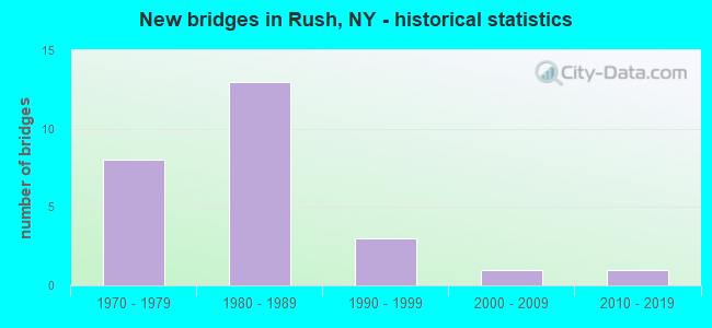
- New bridges - historical statistics
- 81970-1979
- 131980-1989
- 31990-1999
- 12000-2009
- 12010-2019


- Bridge Condition - Deck
- 7.1%Excellent
- 21.4%Very good
- 42.9%Good
- 21.4%Satisfactory
- 7.1%Poor

- Bridge Condition - Superstructure
- 13.3%Very good
- 73.3%Good
- 13.3%Fair

- Bridge Condition - Substructure
- 20.0%Very good
- 20.0%Good
- 60.0%Satisfactory

- Bridge Condition - Channel
- 14.3%Very good
- 85.7%Good
Find on map >> Show street view
Structure Number: 101151, Location: 1.2MI S JCT RTS 15 & 251 (Lat: 42.986775, Lng: -77.672325), Route carried "on" structure: US 15, Year Built: 1983, Status: Open, Structure Length: 3.17m (10.40ft), Average Daily Traffic: 3,466 (year 2018), Truck Traffic: 9%, Average Future Daily Traffic: 3,487 (year 2040), Design Load: HS 20, Features Intersected: HONEOYE CREEK
Minimum Vertical Clearance: 30+ m (98+ ft), Kilometerpoint: 5.696, Lanes on structure: 2, Base Highway Network: Yes, Owner: State Highway Agency, Approaching Roadway Width: 12.2m (40.0ft), Skew: 3 degrees, Material/Design: Prestressed concrete, Design/Construction: Box Beam or Girders - Multiple, Number Of Spans In Main Unit: 1, Length of Maximum Span: 30.4m (99.7ft), Curb-To-Curb Width: 12.2m (40.0ft), Out-to-Out Width: 12.9m (42.3ft)
Condition: Deck: Satisfactory, Superstructure: Fair, Substructure: Satisfactory, Channel: Good, Inventory Rating: 61.7 metric tons, Method Used To Determine Inventory Rating: Load Factor (LF), Structural Evaluation: Somewhat better than minimum adequacy, Deck Geometry: Equal to present minimum criteria, Waterway Adequacy: Somewhat better than minimum adequacy, Approach Roadway Alignment: Equal to present desirable criteria, Length Of Structure Improvement: 3.16m (10.37ft), Designated Inspection Frequency: Every 24 months, Inspection Date: May 2020, Bridge Improvement Cost: $1,392,000, Roadway Improvement Cost: $815,000, Total Project Cost: $2,208,000 ( Estimate for 2021), Deck Structure Type: Concrete Cast-file-Place, Wearing Surface/Protective System: Wearing Surface: Bituminous, Membrane: Other
Find on map >> Show street view
Structure Number: 101152, Location: 0.6MI S JCT RTS 15 & 251 (Lat: 42.993422, Lng: -77.669175), Route carried "on" structure: State highway 15, Year Built: 2007, Status: Open, Structure Length: 1.04m (3.41ft), Average Daily Traffic: 3,466 (year 2018), Truck Traffic: 9%, Average Future Daily Traffic: 3,487 (year 2040), Design Load: HS 25 or greater, Features Intersected: LEHIGH VALLEY TRA
Minimum Vertical Clearance: 30+ m (98+ ft), Kilometerpoint: 6.484, Lanes on structure: 2, Base Highway Network: Yes, Owner: County Highway Agency, Approaching Roadway Width: 11.9m (39.0ft), Skew: 1 degrees, Material/Design: Concrete, Design/Construction: Frame, Number Of Spans In Main Unit: 1, Length of Maximum Span: 10.1m (33.1ft), Curb-To-Curb Width: 12.0m (39.4ft), Out-to-Out Width: 13.0m (42.7ft)
Condition: Superstructure: Good, Substructure: Very good, Inventory Rating: 64.4 metric tons, Method Used To Determine Inventory Rating: Load Factor (LF), Structural Evaluation: Better than present minimum criteria, Deck Geometry: Somewhat better than minimum adequacy, Approach Roadway Alignment: Equal to present desirable criteria, Length Of Structure Improvement: 1.03m (3.38ft), Designated Inspection Frequency: Every 24 months, Inspection Date: August 2021, Bridge Improvement Cost: $658,000, Roadway Improvement Cost: $386,000, Total Project Cost: $1,044,000 ( Estimate for 2021)
Find on map >> Show street view
Structure Number: 101161, Location: 0.2 MI S JCT RTS 15A &251 (Lat: 42.993047, Lng: -77.645414), Route carried "on" structure: State highway 15A, Year Built: 1992, Status: Open, Structure Length: 3.35m (10.99ft), Average Daily Traffic: 7,874 (year 2020), Truck Traffic: 6%, Average Future Daily Traffic: 7,922 (year 2040), Design Load: HS 20, Features Intersected: HONEOYE CREEK
Minimum Vertical Clearance: 30+ m (98+ ft), Kilometerpoint: 6.935, Lanes on structure: 2, Base Highway Network: Yes, Owner: State Highway Agency, Approaching Roadway Width: 10.4m (34.1ft), Skew: 3 degrees, Material/Design: Prestressed concrete, Design/Construction: Box Beam or Girders - Multiple, Number Of Spans In Main Unit: 1, Length of Maximum Span: 32.0m (105.0ft), Curb or Sidewalk Widths: Left: 1.5m (4.9ft), Right: 1.5m (4.9ft), Curb-To-Curb Width: 10.4m (34.1ft), Out-to-Out Width: 14.4m (47.2ft)
Condition: Deck: Very good, Superstructure: Good, Substructure: Good, Channel: Good, Operating Rating: 88.9 metric tons, Method Used To Determine Operating Rating: Load Factor (LF), Inventory Rating: 44.5 metric tons, Method Used To Determine Inventory Rating: Load Factor (LF), Structural Evaluation: Better than present minimum criteria, Deck Geometry: Meets minimum limits, Waterway Adequacy: Somewhat better than minimum adequacy, Approach Roadway Alignment: Equal to present desirable criteria, Length Of Structure Improvement: 3.35m (10.99ft), Designated Inspection Frequency: Every 24 months, Inspection Date: May 2021, Bridge Improvement Cost: $1,391,000, Roadway Improvement Cost: $815,000, Total Project Cost: $2,206,000 ( Estimate for 2021), Wearing Surface/Protective System: Wearing Surface: Bituminous, Membrane: Other
Find on map >> Show street view
Structure Number: 106904, Location: 0.2MI.W.JCT.RTS. 251 & 15 (Lat: 43.003039, Lng: -77.669294), Route carried "on" structure: State highway 251, Year Built: 1976, Status: Open, Structure Length: 8.96m (29.40ft), Average Daily Traffic: 3,571 (year 2020), Truck Traffic: 8%, Average Future Daily Traffic: 3,593 (year 2040), Design Load: HS 20, Features Intersected: 390I390I43031047, RTE I3
Minimum Vertical Clearance: 30+ m (98+ ft), Kilometerpoint: 7.836, Lanes on structure: 5, Lanes under structure: 4, Base Highway Network: Yes, Owner: State Highway Agency, Approaching Roadway Width: 20.1m (65.9ft), Skew: 22 degrees, Material/Design: Steel continuous, Design/Construction: Stringer/Multi-beam, Number Of Spans In Main Unit: 2, Length of Maximum Span: 44.1m (144.7ft), Curb or Sidewalk Widths: Left: 1.2m (3.9ft), Right: 1.2m (3.9ft), Curb-To-Curb Width: 20.1m (65.9ft), Out-to-Out Width: 23.2m (76.1ft)
Condition: Deck: Poor, Superstructure: Good, Substructure: Satisfactory, Operating Rating: 65.3 metric tons, Method Used To Determine Operating Rating: Load Factor (LF), Inventory Rating: 39.0 metric tons, Method Used To Determine Inventory Rating: Load Factor (LF), Structural Evaluation: Equal to present minimum criteria, Deck Geometry: Somewhat better than minimum adequacy, Underclear: Meets minimum limits, Approach Roadway Alignment: Equal to present desirable criteria, Length Of Structure Improvement: 8.96m (29.40ft), Designated Inspection Frequency: Every 24 months, Inspection Date: June 2020, Bridge Improvement Cost: $5,089,000, Roadway Improvement Cost: $2,980,000, Total Project Cost: $8,069,000 ( Estimate for 2021), Deck Structure Type: Concrete Cast-file-Place, Wearing Surface/Protective System: Wearing Surface: Bituminous, Membrane: Preformed Fabric
Find on map >> Show street view
Structure Number: 106905, Location: JCT SH 15 & I390 (Lat: 43.006417, Lng: -77.666644), Route carried "on" structure: State highway 15, Year Built: 1977, Year Reconstructed: 2012, Status: Open, Structure Length: 11.80m (38.71ft), Average Daily Traffic: 9,926 (year 2020), Truck Traffic: 7%, Average Future Daily Traffic: 12,058 (year 2040), Design Load: HS 20, Features Intersected: 390I390I43031050 NB, RTE
Minimum Vertical Clearance: 30+ m (98+ ft), Kilometerpoint: 7.868, Lanes on structure: 5, Lanes under structure: 4, Base Highway Network: Yes, Owner: State Highway Agency, Approaching Roadway Width: 20.1m (65.9ft), Skew: 25 degrees, Material/Design: Steel continuous, Design/Construction: Stringer/Multi-beam, Number Of Spans In Main Unit: 2, Length of Maximum Span: 57.9m (190.0ft), Curb-To-Curb Width: 21.8m (71.5ft), Out-to-Out Width: 23.2m (76.1ft)
Condition: Deck: Excellent, Superstructure: Fair, Substructure: Satisfactory, Operating Rating: 93.4 metric tons, Method Used To Determine Operating Rating: Load Factor (LF), Inventory Rating: 55.3 metric tons, Method Used To Determine Inventory Rating: Load Factor (LF), Structural Evaluation: Somewhat better than minimum adequacy, Deck Geometry: Somewhat better than minimum adequacy, Underclear: Somewhat better than minimum adequacy, Approach Roadway Alignment: Equal to present desirable criteria, Length Of Structure Improvement: 11.79m (38.68ft), Designated Inspection Frequency: Every 24 months, Inspection Date: September 2021, Bridge Improvement Cost: $8,205,000, Roadway Improvement Cost: $4,805,000, Total Project Cost: $13,009,000 ( Estimate for 2021), Deck Structure Type: Concrete Cast-file-Place, Wearing Surface/Protective System: Wearing Surface: Integral Concrete, Deck Protection: Epoxy Coated Reinforcing
Find on map >> Show street view
Structure Number: 1069061, Location: 2 MILES South OF THRUWAY (Lat: 43.017789, Lng: -77.659711), Route carried "on" structure: Interstate 390, Year Built: 1977, Status: Open, Structure Length: 3.60m (11.81ft), Average Daily Traffic: 19,703 (year 2006), Truck Traffic: 11%, Design Load: HS 20, Features Intersected: RUSH-HEN.TN LN RD
Minimum Vertical Clearance: 30+ m (98+ ft), Kilometerpoint: 9.461, Lanes on structure: 2, Lanes under structure: 2, Base Highway Network: Yes, Owner: State Highway Agency, Approaching Roadway Width: 12.8m (42.0ft), Skew: 2 degrees, Material/Design: Steel, Design/Construction: Stringer/Multi-beam, Number Of Spans In Main Unit: 1, Length of Maximum Span: 34.7m (113.8ft), Curb-To-Curb Width: 12.5m (41.0ft), Out-to-Out Width: 13.4m (44.0ft)
Condition: Deck: Good, Superstructure: Good, Substructure: Good, Operating Rating: 85.3 metric tons, Method Used To Determine Operating Rating: Load Factor (LF), Inventory Rating: 50.8 metric tons, Method Used To Determine Inventory Rating: Load Factor (LF), Structural Evaluation: Better than present minimum criteria, Deck Geometry: Better than present minimum criteria, Underclear: Equal to present minimum criteria, Approach Roadway Alignment: Equal to present desirable criteria, Length Of Structure Improvement: 3.59m (11.78ft), Designated Inspection Frequency: Every 24 months, Inspection Date: June 2020, Bridge Improvement Cost: $1,447,000, Roadway Improvement Cost: $847,000, Total Project Cost: $2,294,000 ( Estimate for 2021), Deck Structure Type: Concrete Cast-file-Place, Wearing Surface/Protective System: Wearing Surface: Integral Concrete
Find on map >> Show street view
Structure Number: 1069062, Location: 2 MILES South OF THRUWAY (Lat: 43.017792, Lng: -77.659247), Route carried "on" structure: Interstate 390, Year Built: 1977, Status: Open, Structure Length: 3.60m (11.81ft), Average Daily Traffic: 12,365 (year 2018), Truck Traffic: 9%, Average Future Daily Traffic: 17,195 (year 2040), Design Load: HS 20, Features Intersected: RUSH-HEN.TN LN RD
Minimum Vertical Clearance: 30+ m (98+ ft), Kilometerpoint: 9.429, Lanes on structure: 2, Lanes under structure: 2, Base Highway Network: Yes, Owner: State Highway Agency, Approaching Roadway Width: 12.8m (42.0ft), Skew: 2 degrees, Material/Design: Steel, Design/Construction: Stringer/Multi-beam, Number Of Spans In Main Unit: 1, Length of Maximum Span: 34.7m (113.8ft), Curb-To-Curb Width: 12.5m (41.0ft), Out-to-Out Width: 13.4m (44.0ft)
Condition: Deck: Good, Superstructure: Good, Substructure: Good, Operating Rating: 85.3 metric tons, Method Used To Determine Operating Rating: Load Factor (LF), Inventory Rating: 50.8 metric tons, Method Used To Determine Inventory Rating: Load Factor (LF), Structural Evaluation: Better than present minimum criteria, Deck Geometry: Better than present minimum criteria, Underclear: Meets minimum limits, Approach Roadway Alignment: Equal to present desirable criteria, Length Of Structure Improvement: 3.59m (11.78ft), Designated Inspection Frequency: Every 24 months, Inspection Date: June 2020, Bridge Improvement Cost: $1,392,000, Roadway Improvement Cost: $815,000, Total Project Cost: $2,208,000 ( Estimate for 2021), Deck Structure Type: Concrete Cast-file-Place, Wearing Surface/Protective System: Wearing Surface: Integral Concrete
Find on map >> Show street view
Structure Number: 107028, Location: 0.3 MI S JCT RT 15 & I390 (Lat: 42.947761, Lng: -77.696533), Route carried "on" structure: County highway , Year Built: 1980, Status: Open, Structure Length: 8.63m (28.31ft), Average Daily Traffic: 1,690 (year 2020), Truck Traffic: 33%, Average Future Daily Traffic: 1,763 (year 2040), Design Load: HS 20, Features Intersected: 390I390I43031006 NB, RTE, Facility Carried by Structure: HONEOYE FALLS RD
Minimum Vertical Clearance: 30+ m (98+ ft), Kilometerpoint: 2.285, Lanes on structure: 2, Lanes under structure: 4, Owner: State Highway Agency, Approaching Roadway Width: 13.4m (44.0ft), Skew: 2 degrees, Material/Design: Steel continuous, Design/Construction: Stringer/Multi-beam, Number Of Spans In Main Unit: 2, Length of Maximum Span: 42.3m (138.8ft), Curb-To-Curb Width: 13.4m (44.0ft), Out-to-Out Width: 14.3m (46.9ft)
Condition: Deck: Satisfactory, Superstructure: Good, Substructure: Satisfactory, Inventory Rating: 63.5 metric tons, Method Used To Determine Inventory Rating: Load Factor (LF), Structural Evaluation: Equal to present minimum criteria, Deck Geometry: Equal to present desirable criteria, Underclear: Equal to present desirable criteria, Approach Roadway Alignment: Equal to present desirable criteria, Length Of Structure Improvement: 8.62m (28.28ft), Designated Inspection Frequency: Every 24 months, Inspection Date: August 2020, Bridge Improvement Cost: $2,981,000, Roadway Improvement Cost: $1,746,000, Total Project Cost: $4,727,000 ( Estimate for 2021), Deck Structure Type: Concrete Cast-file-Place, Wearing Surface/Protective System: Wearing Surface: Integral Concrete, Deck Protection: Epoxy Coated Reinforcing
Find on map >> Show street view
Structure Number: 107029, Location: JCT OF RTS 15 & I-390 (Lat: 42.949728, Lng: -77.697339), Route carried "on" structure: State highway 15, Year Built: 1980, Status: Open, Structure Length: 10.58m (34.71ft), Average Daily Traffic: 3,466 (year 2018), Truck Traffic: 9%, Average Future Daily Traffic: 3,487 (year 2040), Design Load: HS 20, Features Intersected: 390I390I43031007 SB, RTE
Minimum Vertical Clearance: 30+ m (98+ ft), Kilometerpoint: 1.046, Lanes on structure: 4, Lanes under structure: 4, Base Highway Network: Yes, Owner: State Highway Agency, Approaching Roadway Width: 14.6m (47.9ft), Skew: 4 degrees, Material/Design: Steel continuous, Design/Construction: Stringer/Multi-beam, Number Of Spans In Main Unit: 2, Length of Maximum Span: 51.8m (169.9ft), Curb-To-Curb Width: 14.6m (47.9ft), Out-to-Out Width: 15.5m (50.9ft)
Condition: Deck: Good, Superstructure: Good, Substructure: Satisfactory, Operating Rating: 62.9 metric tons, Method Used To Determine Operating Rating: Load and Resistance Factor Rating (LRFR) rating reported by rating factor(RF) method using HL-93 loadings, Inventory Rating: 48.6 metric tons, Method Used To Determine Inventory Rating: Load and Resistance Factor Rating (LRFR) rating reported by rating factor(RF) method using HL-93 loadings, Structural Evaluation: Equal to present minimum criteria, Deck Geometry: High priority of replacement, Underclear: Equal to present minimum criteria, Approach Roadway Alignment: Equal to present desirable criteria, Length Of Structure Improvement: 10.57m (34.68ft), Designated Inspection Frequency: Every 24 months, Inspection Date: May 2021, Bridge Improvement Cost: $4,171,000, Roadway Improvement Cost: $2,443,000, Total Project Cost: $6,614,000 ( Estimate for 2021), Deck Structure Type: Concrete Cast-file-Place, Wearing Surface/Protective System: Wearing Surface: Integral Concrete, Deck Protection: Epoxy Coated Reinforcing
Find on map >> Show street view
Structure Number: 1070301, Location: 2 MI N JCT SH 15 & I390 (Lat: 42.978667, Lng: -77.683403), Route carried "on" structure: Interstate 390, Year Built: 1980, Status: Open, Structure Length: 4.18m (13.71ft), Average Daily Traffic: 10,391 (year 2008), Truck Traffic: 18%, Design Load: HS 20, Features Intersected: CR65-RUSH W RH RD
Minimum Vertical Clearance: 30+ m (98+ ft), Kilometerpoint: 4.650, Lanes on structure: 2, Lanes under structure: 2, Base Highway Network: Yes, Owner: State Highway Agency, Approaching Roadway Width: 13.1m (43.0ft), Skew: 2 degrees, Material/Design: Steel, Design/Construction: Stringer/Multi-beam, Number Of Spans In Main Unit: 1, Length of Maximum Span: 40.2m (131.9ft), Curb-To-Curb Width: 12.9m (42.3ft), Out-to-Out Width: 13.8m (45.3ft)
Condition: Deck: Good, Superstructure: Good, Substructure: Satisfactory, Operating Rating: 57.0 metric tons, Method Used To Determine Operating Rating: Load and Resistance Factor Rating (LRFR) rating reported by rating factor(RF) method using HL-93 loadings, Inventory Rating: 44.1 metric tons, Method Used To Determine Inventory Rating: Load and Resistance Factor Rating (LRFR) rating reported by rating factor(RF) method using HL-93 loadings, Structural Evaluation: Equal to present minimum criteria, Deck Geometry: Superior to present desirable criteria, Underclear: Better than present minimum criteria, Approach Roadway Alignment: Equal to present desirable criteria, Length Of Structure Improvement: 4.17m (13.68ft), Designated Inspection Frequency: Every 24 months, Inspection Date: May 2021, Bridge Improvement Cost: $1,766,000, Roadway Improvement Cost: $1,034,000, Total Project Cost: $2,800,000 ( Estimate for 2021), Deck Structure Type: Concrete Cast-file-Place, Wearing Surface/Protective System: Wearing Surface: Latex Concrete, Deck Protection: Epoxy Coated Reinforcing
Find on map >> Show street view
Structure Number: 1070302, Location: 2 MI N JCT SH 15 & I390 (Lat: 42.978789, Lng: -77.682819), Route carried "on" structure: Interstate 390, Year Built: 1980, Status: Open, Structure Length: 4.18m (13.71ft), Average Daily Traffic: 9,291 (year 2019), Truck Traffic: 11%, Average Future Daily Traffic: 11,395 (year 2040), Design Load: HS 20, Features Intersected: CR65-RUSH W RH RD
Minimum Vertical Clearance: 30+ m (98+ ft), Kilometerpoint: 4.634, Lanes on structure: 2, Lanes under structure: 2, Base Highway Network: Yes, Owner: State Highway Agency, Approaching Roadway Width: 13.1m (43.0ft), Skew: 2 degrees, Material/Design: Steel, Design/Construction: Stringer/Multi-beam, Number Of Spans In Main Unit: 1, Length of Maximum Span: 40.2m (131.9ft), Curb-To-Curb Width: 12.9m (42.3ft), Out-to-Out Width: 13.8m (45.3ft)
Condition: Deck: Good, Superstructure: Very good, Substructure: Satisfactory, Operating Rating: 67.1 metric tons, Method Used To Determine Operating Rating: Load and Resistance Factor Rating (LRFR) rating reported by rating factor(RF) method using HL-93 loadings, Inventory Rating: 51.8 metric tons, Method Used To Determine Inventory Rating: Load and Resistance Factor Rating (LRFR) rating reported by rating factor(RF) method using HL-93 loadings, Structural Evaluation: Equal to present minimum criteria, Deck Geometry: Somewhat better than minimum adequacy, Underclear: Equal to present minimum criteria, Approach Roadway Alignment: Equal to present desirable criteria, Length Of Structure Improvement: 4.17m (13.68ft), Designated Inspection Frequency: Every 24 months, Inspection Date: May 2021, Bridge Improvement Cost: $1,766,000, Roadway Improvement Cost: $1,034,000, Total Project Cost: $2,800,000 ( Estimate for 2021), Deck Structure Type: Concrete Cast-file-Place, Wearing Surface/Protective System: Wearing Surface: Epoxy Overlay, Deck Protection: Epoxy Coated Reinforcing
Find on map >> Show street view
Structure Number: 1070311, Location: 1 MI S JCT RTS 251 & I390 (Lat: 42.990725, Lng: -77.679775), Route carried "on" structure: Interstate 390, Year Built: 1980, Status: Open, Structure Length: 13.38m (43.90ft), Average Daily Traffic: 10,391 (year 2008), Truck Traffic: 18%, Design Load: HS 20, Features Intersected: FISHELL ROAD, HONEOYE CR
Minimum Vertical Clearance: 30+ m (98+ ft), Kilometerpoint: 5.921, Lanes on structure: 2, Lanes under structure: 2, Base Highway Network: Yes, Owner: State Highway Agency, Approaching Roadway Width: 12.2m (40.0ft), Skew: 1 degrees, Material/Design: Steel continuous, Design/Construction: Stringer/Multi-beam, Number Of Spans In Main Unit: 3, Length of Maximum Span: 49.3m (161.7ft), Curb-To-Curb Width: 12.6m (41.3ft), Out-to-Out Width: 13.6m (44.6ft)
Condition: Deck: Satisfactory, Superstructure: Good, Substructure: Satisfactory, Channel: Good, Operating Rating: 85.3 metric tons, Method Used To Determine Operating Rating: Load Factor (LF), Inventory Rating: 50.8 metric tons, Method Used To Determine Inventory Rating: Load Factor (LF), Structural Evaluation: Equal to present minimum criteria, Deck Geometry: Better than present minimum criteria, Underclear: Equal to present minimum criteria, Waterway Adequacy: Superior to present desirable criteria, Approach Roadway Alignment: Equal to present desirable criteria, Length Of Structure Improvement: 13.38m (43.90ft), Designated Inspection Frequency: Every 24 months, Inspection Date: October 2021, Bridge Improvement Cost: $4,328,000, Roadway Improvement Cost: $2,535,000, Total Project Cost: $6,863,000 ( Estimate for 2021), Deck Structure Type: Concrete Cast-file-Place, Wearing Surface/Protective System: Wearing Surface: Integral Concrete, Deck Protection: Epoxy Coated Reinforcing
Find on map >> Show street view
Structure Number: 1070312, Location: 1 MI S JCT RTS 251 & I390 (Lat: 42.990644, Lng: -77.679214), Route carried "on" structure: Interstate 390, Year Built: 1980, Status: Open, Structure Length: 12.92m (42.39ft), Average Daily Traffic: 9,291 (year 2019), Truck Traffic: 11%, Average Future Daily Traffic: 11,395 (year 2040), Design Load: HS 20, Features Intersected: FISHELL ROAD, HONEOYE CR
Minimum Vertical Clearance: 30+ m (98+ ft), Kilometerpoint: 5.873, Lanes on structure: 2, Lanes under structure: 2, Base Highway Network: Yes, Owner: State Highway Agency, Approaching Roadway Width: 11.6m (38.1ft), Skew: 1 degrees, Material/Design: Steel continuous, Design/Construction: Stringer/Multi-beam, Number Of Spans In Main Unit: 3, Length of Maximum Span: 49.3m (161.7ft), Curb-To-Curb Width: 12.6m (41.3ft), Out-to-Out Width: 13.6m (44.6ft)
Condition: Deck: Good, Superstructure: Good, Substructure: Satisfactory, Channel: Good, Operating Rating: 87.1 metric tons, Method Used To Determine Operating Rating: Load Factor (LF), Inventory Rating: 52.6 metric tons, Method Used To Determine Inventory Rating: Load Factor (LF), Structural Evaluation: Equal to present minimum criteria, Deck Geometry: Better than present minimum criteria, Underclear: Equal to present minimum criteria, Waterway Adequacy: Superior to present desirable criteria, Approach Roadway Alignment: Equal to present desirable criteria, Length Of Structure Improvement: 12.92m (42.39ft), Designated Inspection Frequency: Every 24 months, Inspection Date: October 2021, Bridge Improvement Cost: $4,218,000, Roadway Improvement Cost: $2,470,000, Total Project Cost: $6,688,000 ( Estimate for 2021), Deck Structure Type: Concrete Cast-file-Place, Wearing Surface/Protective System: Wearing Surface: Integral Concrete, Deck Protection: Epoxy Coated Reinforcing
Find on map >> Show street view
Structure Number: 331731, Location: 1 MI SW OF RUSH (Lat: 42.985792, Lng: -77.664967), Route carried "on" structure: County highway , Year Built: 1998, Status: Open, Structure Length: 1.19m (3.90ft), Average Daily Traffic: 799 (year 2016), Truck Traffic: 8%, Average Future Daily Traffic: 1,119 (year 2036), Design Load: HS 25 or greater, Features Intersected: TRIB HONEOYE CRK, Facility Carried by Structure: RUSH - WEST RUSH
Minimum Vertical Clearance: 30+ m (98+ ft), Kilometerpoint: 3.170, Lanes on structure: 2, Owner: County Highway Agency, Approaching Roadway Width: 10.4m (34.1ft), Skew: 2 degrees, Material/Design: Concrete, Design/Construction: Frame, Number Of Spans In Main Unit: 1, Length of Maximum Span: 11.2m (36.7ft), Curb-To-Curb Width: 10.5m (34.4ft), Out-to-Out Width: 11.4m (37.4ft)
Condition: Deck: Very good, Superstructure: Good, Substructure: Very good, Channel: Good, Operating Rating: 80.6 metric tons, Method Used To Determine Operating Rating: Field evaluation and documented engineering judgment, Inventory Rating: 40.8 metric tons, Method Used To Determine Inventory Rating: Field evaluation and documented engineering judgment, Structural Evaluation: Better than present minimum criteria, Deck Geometry: Equal to present minimum criteria, Waterway Adequacy: Equal to present minimum criteria, Approach Roadway Alignment: Equal to present desirable criteria, Length Of Structure Improvement: 1.18m (3.87ft), Designated Inspection Frequency: Every 24 months, Inspection Date: March 2021, Bridge Improvement Cost: $455,000, Roadway Improvement Cost: $267,000, Total Project Cost: $722,000 ( Estimate for 2021)
Find on map >> Show street view
Structure Number: 331789, Location: 3 MI SW OF RUSH (Lat: 42.977806, Lng: -77.698967), Route carried "on" structure: County highway , Year Built: 1997, Status: Open, Structure Length: 3.84m (12.60ft), Average Daily Traffic: 1,250 (year 2020), Truck Traffic: 7%, Average Future Daily Traffic: 1,304 (year 2040), Design Load: HS 25 or greater, Features Intersected: HONEOYE CREEK, Facility Carried by Structure: EAST RIVER ROAD
Minimum Vertical Clearance: 30+ m (98+ ft), Kilometerpoint: 5.181, Lanes on structure: 2, Owner: County Highway Agency, Approaching Roadway Width: 12.2m (40.0ft), Skew: 2 degrees, Material/Design: Steel, Design/Construction: Stringer/Multi-beam, Number Of Spans In Main Unit: 1, Length of Maximum Span: 36.8m (120.7ft), Curb-To-Curb Width: 12.1m (39.7ft), Out-to-Out Width: 12.8m (42.0ft)
Condition: Deck: Very good, Superstructure: Very good, Substructure: Very good, Channel: Good, Operating Rating: 63.2 metric tons, Method Used To Determine Operating Rating: Load and Resistance Factor Rating (LRFR) rating reported by rating factor(RF) method using HL-93 loadings, Inventory Rating: 48.9 metric tons, Method Used To Determine Inventory Rating: Load and Resistance Factor Rating (LRFR) rating reported by rating factor(RF) method using HL-93 loadings, Structural Evaluation: Equal to present desirable criteria, Deck Geometry: Equal to present minimum criteria, Waterway Adequacy: Superior to present desirable criteria, Approach Roadway Alignment: Equal to present desirable criteria, Length Of Structure Improvement: 3.84m (12.60ft), Designated Inspection Frequency: Every 24 months, Inspection Date: June 2021, Bridge Improvement Cost: $1,377,000, Roadway Improvement Cost: $806,000, Total Project Cost: $2,183,000 ( Estimate for 2021), Deck Structure Type: Concrete Cast-file-Place, Wearing Surface/Protective System: Wearing Surface: Integral Concrete, Deck Protection: Epoxy Coated Reinforcing
Find on map >> Show street view
Structure Number: 337079, Location: 1.8 m E. of I-390 (Lat: 42.947208, Lng: -77.661656), Route carried "on" structure: County highway , Year Built: 2011, Status: Open, Structure Length: 0.67m (2.20ft), Average Daily Traffic: 2,426 (year 2017), Truck Traffic: 10%, Average Future Daily Traffic: 2,530 (year 2040), Design Load: HS 25 or greater, Features Intersected: HONEOYE CREEK TRI, Facility Carried by Structure: Honeoye Falls Rd
Minimum Vertical Clearance: 30+ m (98+ ft), Kilometerpoint: 8.270, Lanes on structure: 2, Owner: County Highway Agency, Approaching Roadway Width: 7.3m (24.0ft), Material/Design: Concrete, Design/Construction: Culvert, Number Of Spans In Main Unit: 1, Length of Maximum Span: 6.1m (20.0ft), Curb-To-Curb Width: 10.4m (34.1ft), Out-to-Out Width: 12.0m (39.4ft)
Condition: Channel: Very good, Culverts: Very good, Operating Rating: 79.8 metric tons, Method Used To Determine Operating Rating: Load Factor (LF), Inventory Rating: 47.2 metric tons, Method Used To Determine Inventory Rating: Load Factor (LF), Structural Evaluation: Equal to present desirable criteria, Deck Geometry: Somewhat better than minimum adequacy, Waterway Adequacy: Somewhat better than minimum adequacy, Approach Roadway Alignment: Equal to present desirable criteria, Length Of Structure Improvement: 0.67m (2.20ft), Designated Inspection Frequency: Every 24 months, Inspection Date: December 2021, Bridge Improvement Cost: $144,000, Roadway Improvement Cost: $84,000, Total Project Cost: $228,000 ( Estimate for 2021), Wearing Surface/Protective System: Wearing Surface: Bituminous
Find on map >> Show street view
Structure Number: 106904, Location: 0.2MI.W.JCT.RTS. 251 & 15 (Lat: 43.003039, Lng: -77.669294), Route carried "under" structure: Interstate 390, Year Built: 1976, Structure Length: 0. m, Average Daily Traffic: 28,103 (year 2002), Features Intersected: 390I390I43031047, RTE I3, Facility Carried by Structure: RTE 251
Minimum Vertical Clearance: 5.23m (17.16ft), Kilometerpoint: 7.675, Lanes on structure: 5, Lanes under structure: 2, Material/Design: Steel continuous, Design/Construction: Stringer/Multi-beam, Length of Maximum Span: 44.1m (144.7ft)
Find on map >> Show street view
Structure Number: 106905, Location: JCT SH 15 & I390 (Lat: 43.006417, Lng: -77.666644), Route carried "under" structure: Interstate 390, Year Built: 1977, Structure Length: 0. m, Average Daily Traffic: 27,881 (year 2015), Features Intersected: 390I390I43031050 NB, RTE, Facility Carried by Structure: RTE 15
Minimum Vertical Clearance: 5.44m (17.85ft), Kilometerpoint: 7.723, Lanes on structure: 5, Lanes under structure: 2, Material/Design: Steel continuous, Design/Construction: Stringer/Multi-beam, Length of Maximum Span: 57.9m (190.0ft)
Find on map >> Show street view
Structure Number: 1069061, Location: 2 MILES South OF THRUWAY (Lat: 43.017789, Lng: -77.659711), Route carried "under" structure: Other road , Year Built: 1977, Structure Length: 0. m, Features Intersected: RUSH-HEN.TN LN RD, Facility Carried by Structure: RTE I390
Minimum Vertical Clearance: 4.60m (15.09ft), Kilometerpoint: 0.000, Lanes on structure: 2, Lanes under structure: 2, Material/Design: Steel, Design/Construction: Stringer/Multi-beam, Length of Maximum Span: 34.7m (113.8ft)
Find on map >> Show street view
Structure Number: 1069062, Location: 2 MILES South OF THRUWAY (Lat: 43.017792, Lng: -77.659247), Route carried "under" structure: Other road , Year Built: 1977, Structure Length: 0. m, Features Intersected: RUSH-HEN.TN LN RD, Facility Carried by Structure: RTE I390
Minimum Vertical Clearance: 4.32m (14.17ft), Kilometerpoint: 3.990, Lanes on structure: 2, Lanes under structure: 2, Material/Design: Steel, Design/Construction: Stringer/Multi-beam, Length of Maximum Span: 34.7m (113.8ft)
Find on map >> Show street view
Structure Number: 107028, Location: 0.3 MI S JCT RT 15 & I390 (Lat: 42.947761, Lng: -77.696533), Route carried "under" structure: Interstate 390, Year Built: 1980, Structure Length: 0. m, Average Daily Traffic: 15,000 (year 1981), Features Intersected: 390I390I43031006 NB, RTE, Facility Carried by Structure: HONEOYE FALLS RD
Minimum Vertical Clearance: 5.59m (18.34ft), Kilometerpoint: 0.965, Lanes on structure: 2, Lanes under structure: 2, Material/Design: Steel continuous, Design/Construction: Stringer/Multi-beam, Length of Maximum Span: 42.3m (138.8ft)
Find on map >> Show street view
Structure Number: 107029, Location: JCT OF RTS 15 & I-390 (Lat: 42.949728, Lng: -77.697339), Route carried "under" structure: Interstate 390, Year Built: 1980, Structure Length: 0. m, Average Daily Traffic: 28,103 (year 2002), Features Intersected: 390I390I43031007 SB, RTE, Facility Carried by Structure: RTE 15
Minimum Vertical Clearance: 5.26m (17.26ft), Kilometerpoint: 0.113, Lanes on structure: 4, Lanes under structure: 2, Material/Design: Steel continuous, Design/Construction: Stringer/Multi-beam, Length of Maximum Span: 51.8m (169.9ft)
Find on map >> Show street view
Structure Number: 1070301, Location: 2 MI N JCT SH 15 & I390 (Lat: 42.978667, Lng: -77.683403), Route carried "under" structure: County highway , Year Built: 1980, Structure Length: 0. m, Average Daily Traffic: 400 (year 2016), Truck Traffic: 8%, Features Intersected: CR65-RUSH W RH RD, Facility Carried by Structure: RTE I390
Minimum Vertical Clearance: 4.80m (15.75ft), Kilometerpoint: 0.000, Lanes on structure: 2, Lanes under structure: 2, Material/Design: Steel, Design/Construction: Stringer/Multi-beam, Length of Maximum Span: 40.2m (131.9ft)
Find on map >> Show street view
Structure Number: 1070302, Location: 2 MI N JCT SH 15 & I390 (Lat: 42.978789, Lng: -77.682819), Route carried "under" structure: County highway , Year Built: 1980, Structure Length: 0. m, Average Daily Traffic: 400 (year 2016), Truck Traffic: 8%, Features Intersected: CR65-RUSH W RH RD, Facility Carried by Structure: RTE I390
Minimum Vertical Clearance: 4.67m (15.32ft), Kilometerpoint: 1.335, Lanes on structure: 2, Lanes under structure: 2, Material/Design: Steel, Design/Construction: Stringer/Multi-beam, Length of Maximum Span: 40.2m (131.9ft)
Find on map >> Show street view
Structure Number: 1070311, Location: 1 MI S JCT RTS 251 & I390 (Lat: 42.990725, Lng: -77.679775), Route carried "under" structure: Other road , Year Built: 1980, Structure Length: 0. m, Average Daily Traffic: 15,000 (year 1981), Features Intersected: FISHELL ROAD, HONEOYE CR, Facility Carried by Structure: RTE I390
Minimum Vertical Clearance: 6.63m (21.75ft), Kilometerpoint: 0.000, Lanes on structure: 2, Lanes under structure: 2, Material/Design: Steel continuous, Design/Construction: Stringer/Multi-beam, Length of Maximum Span: 49.3m (161.7ft)
Find on map >> Show street view
Structure Number: 1070312, Location: 1 MI S JCT RTS 251 & I390 (Lat: 42.990644, Lng: -77.679214), Route carried "under" structure: Other road , Year Built: 1980, Structure Length: 0. m, Average Daily Traffic: 15,000 (year 1981), Features Intersected: FISHELL ROAD, HONEOYE CR, Facility Carried by Structure: RTE I390
Minimum Vertical Clearance: 5.61m (18.41ft), Kilometerpoint: 0.000, Lanes on structure: 2, Lanes under structure: 2, Material/Design: Steel continuous, Design/Construction: Stringer/Multi-beam, Length of Maximum Span: 49.3m (161.7ft)