Bridge Statistics for Russia, New York (NY)
Condition, Traffic, Stress, Structural Evaluation, Project Costs
- National Bridge Inventory (NBI) Statistics
- 10Number of bridges
- 79ft / 24.4mTotal length
- $7,216,000Total costs
- 6,667Total average daily traffic
- 670Total average daily truck traffic
- 7,585Total future (year 2037) average daily traffic
- National Bridge Inventory (NBI) Registered Bridges for Russia
- No street view available for this location
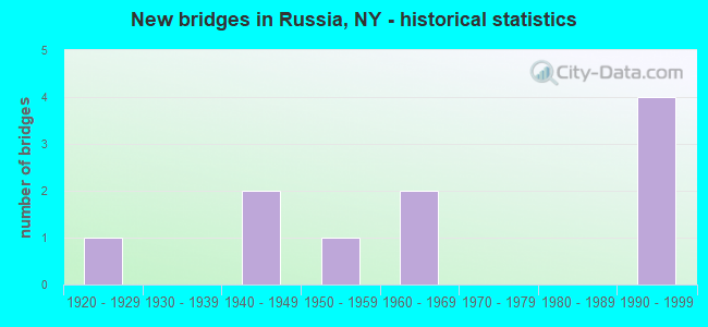
- New bridges - historical statistics
- 11920-1929
- 21940-1949
- 11950-1959
- 21960-1969
- 41990-1999

- Reconstructed bridges - Historical Statistics
- 11980-1989
- 11990-1999

- Bridge Condition - Deck
- 14.3%Excellent
- 14.3%Very good
- 28.6%Good
- 28.6%Satisfactory
- 14.3%Fair

- Bridge Condition - Superstructure
- 14.3%Excellent
- 14.3%Very good
- 28.6%Good
- 28.6%Satisfactory
- 14.3%Fair

- Bridge Condition - Substructure
- 14.3%Very good
- 42.9%Good
- 42.9%Fair

- Bridge Condition - Channel
- 10.0%Very good
- 20.0%Good
- 40.0%Satisfactory
- 30.0%Fair
Find on map >> Show street view
Structure Number: 100471, Location: .9 MI N JCT SH 8 & SH 28 (Lat: 43.232889, Lng: -75.048306), Route carried "on" structure: State highway 8, Year Built: 1998, Status: Open, Structure Length: 1.31m (4.30ft), Average Daily Traffic: 2,635 (year 2020), Truck Traffic: 12%, Average Future Daily Traffic: 2,651 (year 2040), Design Load: HS 25 or greater, Features Intersected: COLD BROOK
Minimum Vertical Clearance: 30+ m (98+ ft), Kilometerpoint: 2.639, Lanes on structure: 2, Base Highway Network: Yes, Owner: State Highway Agency, Approaching Roadway Width: 8.5m (27.9ft), Skew: 3 degrees, Material/Design: Prestressed concrete, Design/Construction: Box Beam or Girders - Multiple, Number Of Spans In Main Unit: 1, Length of Maximum Span: 12.1m (39.7ft), Curb or Sidewalk Widths: Left: 0.0m, Right: 1.7m (5.6ft), Curb-To-Curb Width: 8.5m (27.9ft), Out-to-Out Width: 11.0m (36.1ft)
Condition: Deck: Excellent, Superstructure: Excellent, Substructure: Very good, Channel: Very good, Operating Rating: 89.8 metric tons, Method Used To Determine Operating Rating: Load Factor (LF), Inventory Rating: 57.2 metric tons, Method Used To Determine Inventory Rating: Load Factor (LF), Structural Evaluation: Equal to present desirable criteria, Deck Geometry: Meets minimum limits, Waterway Adequacy: Equal to present desirable criteria, Approach Roadway Alignment: Equal to present desirable criteria, Length Of Structure Improvement: 1.31m (4.30ft), Designated Inspection Frequency: Every 24 months, Inspection Date: April 2020, Bridge Improvement Cost: $377,000, Roadway Improvement Cost: $221,000, Total Project Cost: $598,000 ( Estimate for 2021), Wearing Surface/Protective System: Wearing Surface: Bituminous, Membrane: Other
Find on map >> Show street view
Structure Number: 102016, Location: 21MI NE JCT RTS 8+28 (Lat: 43.247444, Lng: -75.121678), Route carried "on" structure: State highway 28, Year Built: 1948, Status: Open, Structure Length: 0.88m (2.89ft), Average Daily Traffic: 1,805 (year 2020), Truck Traffic: 14%, Average Future Daily Traffic: 1,816 (year 2040), Design Load: HS 20, Features Intersected: MILL CREEK
Minimum Vertical Clearance: 30+ m (98+ ft), Kilometerpoint: 3.363, Lanes on structure: 2, Base Highway Network: Yes, Owner: State Highway Agency, Approaching Roadway Width: 10.7m (35.1ft), Material/Design: Concrete, Design/Construction: Culvert, Number Of Spans In Main Unit: 1, Length of Maximum Span: 7.6m (24.9ft)
Condition: Channel: Satisfactory, Culverts: Good, Operating Rating: 81.6 metric tons, Method Used To Determine Operating Rating: Load Factor (LF), Inventory Rating: 48.1 metric tons, Method Used To Determine Inventory Rating: Load Factor (LF), Structural Evaluation: Better than present minimum criteria, Waterway Adequacy: Meets minimum limits, Approach Roadway Alignment: Equal to present desirable criteria, Length Of Structure Improvement: 0.88m (2.89ft), Designated Inspection Frequency: Every 24 months, Inspection Date: October 2020, Bridge Improvement Cost: $184,000, Roadway Improvement Cost: $107,000, Total Project Cost: $291,000 ( Estimate for 2021)
Find on map >> Show street view
Structure Number: 226359, Location: 1.0 MI E OF GRANT (Lat: 43.314064, Lng: -75.039522), Route carried "on" structure: Other road , Year Built: 1940, Status: Posted for load, Structure Length: 3.14m (10.30ft), Average Daily Traffic: 81 (year 2017), Truck Traffic: 4%, Average Future Daily Traffic: 113 (year 2037), Features Intersected: BLACK CREEK, Facility Carried by Structure: BLACK CREEK ROAD
Minimum Vertical Clearance: 30+ m (98+ ft), Kilometerpoint: 0.241, Lanes on structure: 2, Owner: Town or Township Highway Agency, Approaching Roadway Width: 5.2m (17.1ft), Skew: 2 degrees, Material/Design: Steel, Design/Construction: Stringer/Multi-beam, Number Of Spans In Main Unit: 2, Length of Maximum Span: 15.2m (49.9ft), Curb-To-Curb Width: 5.2m (17.1ft), Out-to-Out Width: 5.9m (19.4ft)
Condition: Deck: Satisfactory, Superstructure: Satisfactory, Substructure: Fair, Channel: Good, Operating Rating: 29.0 metric tons, Method Used To Determine Operating Rating: Load Factor (LF), Inventory Rating: 17.2 metric tons, Method Used To Determine Inventory Rating: Load Factor (LF), Structural Evaluation: Somewhat better than minimum adequacy, Deck Geometry: High priority of corrective action, Waterway Adequacy: Better than present minimum criteria, Approach Roadway Alignment: Somewhat better than minimum adequacy, Bridge Posting: Required (Relationship of Operating Rating to Maximum Legal Load: > 39.9% below), Length Of Structure Improvement: 3.13m (10.27ft), Designated Inspection Frequency: Every 12 months, Inspection Date: April 2021, Bridge Improvement Cost: $457,000, Roadway Improvement Cost: $268,000, Total Project Cost: $725,000 ( Estimate for 2021), Deck Structure Type: Concrete Cast-file-Place, Wearing Surface/Protective System: Wearing Surface: Bituminous
Find on map >> Show street view
Structure Number: 226797, Location: 1.0 MI NORTH OF WILMURT (Lat: 43.393308, Lng: -75.058228), Route carried "on" structure: Other road , Year Built: 1920, Year Reconstructed: 1989, Status: Posted for load, Structure Length: 2.13m (6.99ft), Average Daily Traffic: 59 (year 2019), Truck Traffic: 4%, Average Future Daily Traffic: 83 (year 2039), Features Intersected: LITTLE BLACK CREEK, Facility Carried by Structure: WHEELERTOWN ROAD
Minimum Vertical Clearance: 30+ m (98+ ft), Kilometerpoint: 6.516, Lanes on structure: 1, Owner: Town or Township Highway Agency, Approaching Roadway Width: 6.1m (20.0ft), Material/Design: Steel, Design/Construction: Stringer/Multi-beam, Number Of Spans In Main Unit: 1, Length of Maximum Span: 20.7m (67.9ft), Curb-To-Curb Width: 4.2m (13.8ft), Out-to-Out Width: 4.9m (16.1ft)
Condition: Deck: Good, Superstructure: Good, Substructure: Fair, Channel: Satisfactory, Operating Rating: 57.2 metric tons, Method Used To Determine Operating Rating: Allowable Stress (AS), Inventory Rating: 34.5 metric tons, Method Used To Determine Inventory Rating: Allowable Stress (AS), Structural Evaluation: Somewhat better than minimum adequacy, Deck Geometry: Somewhat better than minimum adequacy, Waterway Adequacy: Meets minimum limits, Approach Roadway Alignment: Meets minimum limits, Bridge Posting: Required (Relationship of Operating Rating to Maximum Legal Load: > 39.9% below), Length Of Structure Improvement: 2.13m (6.99ft), Designated Inspection Frequency: Every 12 months, Inspection Date: April 2021, Bridge Improvement Cost: $244,000, Roadway Improvement Cost: $143,000, Total Project Cost: $387,000 ( Estimate for 2021), Deck Structure Type: Wood or Timber, Wearing Surface/Protective System: Wearing Surface: Bituminous
Find on map >> Show street view
Structure Number: 330798, Location: 0.4 MI S GRAVESVILLE (Lat: 43.249492, Lng: -75.114772), Route carried "on" structure: County highway , Year Built: 1996, Status: Open, Structure Length: 0.76m (2.49ft), Average Daily Traffic: 274 (year 2019), Truck Traffic: 4%, Average Future Daily Traffic: 384 (year 2039), Design Load: HS 20, Features Intersected: MILL CREEK, Facility Carried by Structure: CR242 GRAVESVILLE
Minimum Vertical Clearance: 30+ m (98+ ft), Kilometerpoint: 0.579, Lanes on structure: 2, Owner: County Highway Agency, Approaching Roadway Width: 7.3m (24.0ft), Material/Design: Aluminum, Iron, Design/Construction: Culvert, Number Of Spans In Main Unit: 1, Length of Maximum Span: 7.3m (24.0ft)
Condition: Channel: Satisfactory, Culverts: Good, Operating Rating: 77.7 metric tons, Method Used To Determine Operating Rating: Field evaluation and documented engineering judgment, Inventory Rating: 32.7 metric tons, Method Used To Determine Inventory Rating: Field evaluation and documented engineering judgment, Structural Evaluation: Better than present minimum criteria, Waterway Adequacy: Meets minimum limits, Approach Roadway Alignment: Equal to present desirable criteria, Length Of Structure Improvement: 0.76m (2.49ft), Designated Inspection Frequency: Every 24 months, Inspection Date: October 2021, Bridge Improvement Cost: $109,000, Roadway Improvement Cost: $64,000, Total Project Cost: $172,000 ( Estimate for 2021)
Find on map >> Show street view
Structure Number: 330799, Location: .4 MI E OF GRAVESVILLE (Lat: 43.256161, Lng: -75.108194), Route carried "on" structure: County highway , Year Built: 1963, Year Reconstructed: 2001, Status: Open, Structure Length: 0.88m (2.89ft), Average Daily Traffic: 370 (year 2017), Truck Traffic: 8%, Average Future Daily Traffic: 518 (year 2037), Design Load: H 20, Features Intersected: MILL CREEK, Facility Carried by Structure: CR47 RUSSIA ROAD
Minimum Vertical Clearance: 30+ m (98+ ft), Kilometerpoint: 0.660, Lanes on structure: 2, Owner: County Highway Agency, Approaching Roadway Width: 6.1m (20.0ft), Skew: 4 degrees, Material/Design: Steel, Design/Construction: Culvert, Number Of Spans In Main Unit: 1, Length of Maximum Span: 8.5m (27.9ft)
Condition: Channel: Fair, Culverts: Good, Operating Rating: 89.8 metric tons, Method Used To Determine Operating Rating: Load Factor (LF), Inventory Rating: 89.8 metric tons, Method Used To Determine Inventory Rating: Load Factor (LF), Structural Evaluation: Better than present minimum criteria, Waterway Adequacy: Meets minimum limits, Approach Roadway Alignment: Meets minimum limits, Length Of Structure Improvement: 0.88m (2.89ft), Designated Inspection Frequency: Every 24 months, Inspection Date: October 2021, Bridge Improvement Cost: $105,000, Roadway Improvement Cost: $61,000, Total Project Cost: $166,000 ( Estimate for 2021)
Find on map >> Show street view
Structure Number: 3308, Location: 2.5 MI NW OF GRAVESVILLE (Lat: 43.271128, Lng: -75.159208), Route carried "on" structure: County highway , Year Built: 1990, Status: Open, Structure Length: 7.13m (23.39ft), Average Daily Traffic: 423 (year 2019), Truck Traffic: 2%, Average Future Daily Traffic: 592 (year 2039), Design Load: HS 20, Features Intersected: WEST CANADA CREEK, Facility Carried by Structure: CR247 DOVER ROAD
Minimum Vertical Clearance: 30+ m (98+ ft), Kilometerpoint: 0.000, Lanes on structure: 2, Owner: County Highway Agency, Approaching Roadway Width: 7.0m (23.0ft), Material/Design: Steel continuous, Design/Construction: Stringer/Multi-beam, Number Of Spans In Main Unit: 2, Length of Maximum Span: 34.7m (113.8ft), Curb or Sidewalk Widths: Left: 1.8m (5.9ft), Right: 0.0m, Curb-To-Curb Width: 7.2m (23.6ft), Out-to-Out Width: 9.0m (29.5ft)
Condition: Deck: Good, Superstructure: Good, Substructure: Good, Channel: Fair, Operating Rating: 64.4 metric tons, Method Used To Determine Operating Rating: Load Factor (LF), Inventory Rating: 32.7 metric tons, Method Used To Determine Inventory Rating: Load Factor (LF), Structural Evaluation: Better than present minimum criteria, Deck Geometry: Meets minimum limits, Waterway Adequacy: Meets minimum limits, Approach Roadway Alignment: Equal to present desirable criteria, Length Of Structure Improvement: 7.13m (23.39ft), Designated Inspection Frequency: Every 24 months, Inspection Date: June 2020, Bridge Improvement Cost: $1,077,000, Roadway Improvement Cost: $630,000, Total Project Cost: $1,707,000 ( Estimate for 2021), Deck Structure Type: Concrete Cast-file-Place, Wearing Surface/Protective System: Wearing Surface: Integral Concrete, Deck Protection: Epoxy Coated Reinforcing
Find on map >> Show street view
Structure Number: 330801, Location: .5 MILE SE OF PROSPECT (Lat: 43.300406, Lng: -75.144728), Route carried "on" structure: County highway , Year Built: 1959, Status: Open, Structure Length: 1.52m (4.99ft), Average Daily Traffic: 181 (year 2017), Truck Traffic: 7%, Average Future Daily Traffic: 253 (year 2037), Design Load: H 20, Features Intersected: PROSPECT PWR CANAL, Facility Carried by Structure: CR113
Minimum Vertical Clearance: 30+ m (98+ ft), Kilometerpoint: 11.826, Lanes on structure: 2, Owner: County Highway Agency, Approaching Roadway Width: 8.5m (27.9ft), Skew: 3 degrees, Material/Design: Prestressed concrete, Design/Construction: Box Beam or Girders - Multiple, Number Of Spans In Main Unit: 1, Length of Maximum Span: 13.7m (44.9ft), Curb or Sidewalk Widths: Left: 0.5m (1.6ft), Right: 0.5m (1.6ft), Curb-To-Curb Width: 7.4m (24.3ft), Out-to-Out Width: 8.9m (29.2ft)
Condition: Deck: Fair, Superstructure: Fair, Substructure: Good, Channel: Good, Operating Rating: 58.0 metric tons, Method Used To Determine Operating Rating: Field evaluation and documented engineering judgment, Inventory Rating: 23.9 metric tons, Method Used To Determine Inventory Rating: Field evaluation and documented engineering judgment, Structural Evaluation: Somewhat better than minimum adequacy, Deck Geometry: Somewhat better than minimum adequacy, Waterway Adequacy: Somewhat better than minimum adequacy, Approach Roadway Alignment: Better than present minimum criteria, Length Of Structure Improvement: 1.52m (4.99ft), Designated Inspection Frequency: Every 24 months, Underwater Inspection Frequency: Every 60 months, Inspection Date: November 2021, Underwater Inspection Date: August 2017, Bridge Improvement Cost: $592,000, Roadway Improvement Cost: $347,000, Total Project Cost: $939,000 ( Estimate for 2021), Wearing Surface/Protective System: Wearing Surface: Bituminous
Find on map >> Show street view
Structure Number: 330803, Location: 0.1 MI SOUTH OF HINCKLEY (Lat: 43.311442, Lng: -75.113739), Route carried "on" structure: County highway , Year Built: 1992, Status: Open, Structure Length: 4.66m (15.29ft), Average Daily Traffic: 594 (year 2017), Truck Traffic: 5%, Average Future Daily Traffic: 832 (year 2037), Design Load: HS 20+Mod, Features Intersected: WEST CANADA CREEK, Facility Carried by Structure: CR151 HINCKLEY ROA
Minimum Vertical Clearance: 30+ m (98+ ft), Kilometerpoint: 0.000, Lanes on structure: 2, Owner: County Highway Agency, Approaching Roadway Width: 8.8m (28.9ft), Material/Design: Steel, Design/Construction: Stringer/Multi-beam, Number Of Spans In Main Unit: 1, Length of Maximum Span: 45.7m (149.9ft), Curb-To-Curb Width: 8.5m (27.9ft), Out-to-Out Width: 9.1m (29.9ft)
Condition: Deck: Very good, Superstructure: Very good, Substructure: Good, Channel: Satisfactory, Operating Rating: 92.5 metric tons, Method Used To Determine Operating Rating: Load Factor (LF), Inventory Rating: 55.3 metric tons, Method Used To Determine Inventory Rating: Load Factor (LF), Structural Evaluation: Better than present minimum criteria, Deck Geometry: Somewhat better than minimum adequacy, Waterway Adequacy: Meets minimum limits, Approach Roadway Alignment: Equal to present desirable criteria, Length Of Structure Improvement: 4.66m (15.29ft), Designated Inspection Frequency: Every 24 months, Inspection Date: August 2020, Bridge Improvement Cost: $895,000, Roadway Improvement Cost: $524,000, Total Project Cost: $1,418,000 ( Estimate for 2021), Deck Structure Type: Concrete Cast-file-Place, Wearing Surface/Protective System: Wearing Surface: Integral Concrete, Deck Protection: Epoxy Coated Reinforcing
Find on map >> Show street view
Structure Number: 330804, Location: .3 MILE NORTH OF GRANT (Lat: 43.318083, Lng: -75.061039), Route carried "on" structure: Other road , Year Built: 1961, Status: Open, Structure Length: 2.01m (6.59ft), Average Daily Traffic: 245 (year 2020), Truck Traffic: 4%, Average Future Daily Traffic: 343 (year 2040), Design Load: H 20, Features Intersected: BLACK CREEK, Facility Carried by Structure: STORMY HILL ROAD
Minimum Vertical Clearance: 30+ m (98+ ft), Kilometerpoint: 5.503, Lanes on structure: 2, Owner: County Highway Agency, Approaching Roadway Width: 4.6m (15.1ft), Material/Design: Prestressed concrete, Design/Construction: Box Beam or Girders - Multiple, Number Of Spans In Main Unit: 1, Length of Maximum Span: 19.5m (64.0ft), Curb-To-Curb Width: 5.9m (19.4ft), Out-to-Out Width: 6.6m (21.7ft)
Condition: Deck: Satisfactory, Superstructure: Satisfactory, Substructure: Fair, Channel: Fair, Operating Rating: 57.1 metric tons, Method Used To Determine Operating Rating: Field evaluation and documented engineering judgment, Inventory Rating: 20.6 metric tons, Method Used To Determine Inventory Rating: Field evaluation and documented engineering judgment, Structural Evaluation: Somewhat better than minimum adequacy, Deck Geometry: High priority of corrective action, Waterway Adequacy: Somewhat better than minimum adequacy, Approach Roadway Alignment: Meets minimum limits, Length Of Structure Improvement: 2.01m (6.59ft), Designated Inspection Frequency: Every 24 months, Underwater Inspection Frequency: Every 60 months, Inspection Date: October 2021, Underwater Inspection Date: June 2021, Bridge Improvement Cost: $513,000, Roadway Improvement Cost: $300,000, Total Project Cost: $813,000 ( Estimate for 2021), Wearing Surface/Protective System: Wearing Surface: Bituminous