Bridge Statistics for Saginaw Township South, Michigan (MI)
Condition, Traffic, Stress, Structural Evaluation, Project Costs
- National Bridge Inventory (NBI) Statistics
- 37Number of bridges
- 545ft / 166mTotal length
- $136,000Total costs
- 330,095Total average daily traffic
- 23,892Total average daily truck traffic
- National Bridge Inventory (NBI) Registered Bridges for Saginaw Township South
- No street view available for this location
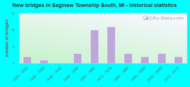
- New bridges - historical statistics
- 21920-1929
- 11930-1939
- 31950-1959
- 101960-1969
- 111970-1979
- 31980-1989
- 21990-1999
- 32000-2009
- 22010-2019
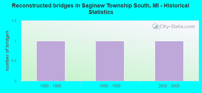
- Reconstructed bridges - Historical Statistics
- 11980-1989
- 11990-1999
- 12000-2009

- Bridge Condition - Deck
- 10.0%Very good
- 23.3%Good
- 36.7%Satisfactory
- 20.0%Fair
- 10.0%Poor
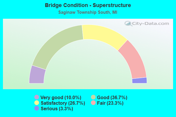
- Bridge Condition - Superstructure
- 10.0%Very good
- 36.7%Good
- 26.7%Satisfactory
- 23.3%Fair
- 3.3%Serious
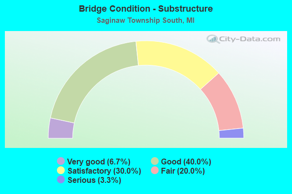
- Bridge Condition - Substructure
- 6.7%Very good
- 40.0%Good
- 30.0%Satisfactory
- 20.0%Fair
- 3.3%Serious
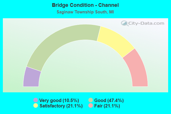
- Bridge Condition - Channel
- 10.5%Very good
- 47.4%Good
- 21.1%Satisfactory
- 21.1%Fair
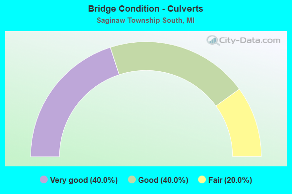
- Bridge Condition - Culverts
- 40.0%Very good
- 40.0%Good
- 20.0%Fair
Find on map >> Show street view
Structure Number: 169, Location: E OF 21ST STREET (Lat: 42.456347, Lng: -85.735458), Route carried "on" structure: County highway 367, Year Built: 1975, Status: Open, Structure Length: 1.31m (4.30ft), Average Daily Traffic: 1,806 (year 2003), Truck Traffic: 7%, Average Future Daily Traffic: 3,612 (year 2023), Design Load: HS 20+Mod, Features Intersected: PINE CREEK, Facility Carried by Structure: JEFFERSON ROAD
Minimum Vertical Clearance: 30.48m (100.00ft), Kilometerpoint: 2.554, Lanes on structure: 2, Owner: County Highway Agency, Approaching Roadway Width: 9.8m (32.2ft), Material/Design: Steel, Design/Construction: Culvert, Number Of Spans In Main Unit: 2, Length of Maximum Span: 6.1m (20.0ft), Curb-To-Curb Width: 12.2m (40.0ft), Out-to-Out Width: 13.4m (44.0ft)
Condition: Channel: Good, Culverts: Fair, Operating Rating: 36.9 metric tons, Method Used To Determine Operating Rating: Load Factor (LF) rating reported by rating factor (RF) method using MS18 loading, Inventory Rating: 22.0 metric tons, Method Used To Determine Inventory Rating: Load Factor (LF) rating reported by rating factor (RF) method using MS18 loading, Structural Evaluation: Somewhat better than minimum adequacy, Deck Geometry: Better than present minimum criteria, Waterway Adequacy: Equal to present desirable criteria, Approach Roadway Alignment: Equal to present desirable criteria, Designated Inspection Frequency: Every 24 months, Inspection Date: September 2021
Find on map >> Show street view
Structure Number: 516, Location: 6 MI W OF BARAGA (Lat: 46.801153, Lng: -88.622436), Route carried "on" structure: County highway , Year Built: 1988, Status: Open, Structure Length: 4.93m (16.17ft), Average Daily Traffic: 176 (year 2015), Truck Traffic: 3%, Average Future Daily Traffic: 250 (year 2035), Design Load: HS 20, Features Intersected: STURGEON RIVER, Facility Carried by Structure: KYRO ROAD
Minimum Vertical Clearance: 30+ m (98+ ft), Kilometerpoint: 4.685, Lanes on structure: 2, Owner: County Highway Agency, Approaching Roadway Width: 8.5m (27.9ft), Material/Design: Prestressed concrete continuous, Design/Construction: Stringer/Multi-beam, Number Of Spans In Main Unit: 3, Length of Maximum Span: 15.4m (50.5ft), Curb-To-Curb Width: 8.5m (27.9ft), Out-to-Out Width: 9.2m (30.2ft)
Condition: Deck: Good, Superstructure: Good, Substructure: Fair, Channel: Satisfactory, Operating Rating: 76.8 metric tons, Method Used To Determine Operating Rating: Load Factor (LF) rating reported by rating factor (RF) method using MS18 loading, Inventory Rating: 46.0 metric tons, Method Used To Determine Inventory Rating: Load Factor (LF) rating reported by rating factor (RF) method using MS18 loading, Structural Evaluation: Somewhat better than minimum adequacy, Deck Geometry: Equal to present minimum criteria, Waterway Adequacy: Better than present minimum criteria, Approach Roadway Alignment: Equal to present desirable criteria, Designated Inspection Frequency: Every 24 months, Inspection Date: September 2021, Deck Structure Type: Concrete Cast-file-Place, Wearing Surface/Protective System: Wearing Surface: Monolithic Concrete, Deck Protection: Epoxy Coated Reinforcing
Find on map >> Show street view
Structure Number: 517, Location: 2 MI SE OF COVINGTON (Lat: 46.533928, Lng: -88.497189), Route carried "on" structure: County highway , Year Built: 2009, Status: Open, Structure Length: 1.53m (5.02ft), Average Daily Traffic: 5 (year 2016), Truck Traffic: 5%, Average Future Daily Traffic: 50 (year 2036), Features Intersected: MURPHY RIVER, Facility Carried by Structure: MURPHY ROAD
Minimum Vertical Clearance: 30+ m (98+ ft), Kilometerpoint: 2.495, Lanes on structure: 2, Owner: County Highway Agency, Approaching Roadway Width: 6.7m (22.0ft), Material/Design: Prestressed concrete, Design/Construction: Box Beam or Girders - Multiple, Number Of Spans In Main Unit: 1, Length of Maximum Span: 13.7m (44.9ft), Curb-To-Curb Width: 8.2m (26.9ft), Out-to-Out Width: 8.6m (28.2ft)
Condition: Deck: Very good, Superstructure: Very good, Substructure: Very good, Channel: Good, Operating Rating: 63.5 metric tons, Method Used To Determine Operating Rating: Load and Resistance Factor (LRFR), Inventory Rating: 48.9 metric tons, Method Used To Determine Inventory Rating: Load and Resistance Factor (LRFR), Structural Evaluation: Equal to present desirable criteria, Deck Geometry: Equal to present minimum criteria, Waterway Adequacy: Equal to present desirable criteria, Approach Roadway Alignment: Equal to present minimum criteria, Designated Inspection Frequency: Every 24 months, Inspection Date: September 2021, Deck Structure Type: Concrete Precast Panels, Wearing Surface/Protective System: Wearing Surface: Bituminous, Membrane: Preformed Fabric, Deck Protection: Epoxy Coated Reinforcing
Find on map >> Show street view
Structure Number: 518, Location: 2 MI E OF COVINGTON (Lat: 46.551953, Lng: -88.475158), Route carried "on" structure: County highway , Year Built: 1924, Status: Open, Structure Length: 1.86m (6.10ft), Average Daily Traffic: 17 (year 2015), Truck Traffic: 5%, Average Future Daily Traffic: 100 (year 2035), Design Load: H 15, Features Intersected: ROCK RIVER, Facility Carried by Structure: OLD M-28
Minimum Vertical Clearance: 30+ m (98+ ft), Kilometerpoint: 3.817, Lanes on structure: 2, Owner: County Highway Agency, Approaching Roadway Width: 7.3m (24.0ft), Material/Design: Concrete, Design/Construction: Girder and Floorbeam System, Number Of Spans In Main Unit: 1, Length of Maximum Span: 17.6m (57.7ft), Curb-To-Curb Width: 6.7m (22.0ft), Out-to-Out Width: 8.5m (27.9ft)
Condition: Deck: Poor, Superstructure: Fair, Substructure: Fair, Channel: Good, Operating Rating: 40.6 metric tons, Method Used To Determine Operating Rating: Field evaluation and documented engineering judgment, Inventory Rating: 24.3 metric tons, Method Used To Determine Inventory Rating: Field evaluation and documented engineering judgment, Structural Evaluation: Somewhat better than minimum adequacy, Deck Geometry: Somewhat better than minimum adequacy, Waterway Adequacy: Better than present minimum criteria, Approach Roadway Alignment: Equal to present minimum criteria, Designated Inspection Frequency: Every 24 months, Inspection Date: September 2021, Deck Structure Type: Concrete Cast-file-Place, Wearing Surface/Protective System: Wearing Surface: Monolithic Concrete
Find on map >> Show street view
Structure Number: 533, Location: 1.0 MI N OF MIDDLEVILLE (Lat: 42.731203, Lng: -85.480553), Route carried "on" structure: State highway 37, Year Built: 1957, Status: Open, Structure Length: 3.35m (10.99ft), Average Daily Traffic: 10,700 (year 2013), Truck Traffic: 4%, Average Future Daily Traffic: 15,628 (year 2018), Design Load: HS 20, Features Intersected: DUNCAN CREEK
Minimum Vertical Clearance: 30.48m (100.00ft), Kilometerpoint: 17.386, Lanes on structure: 2, Base Highway Network: Yes (Inventory Route: 98, Subroute: 10), Owner: State Highway Agency, Approaching Roadway Width: 11.6m (38.1ft), Skew: 1 degrees, Material/Design: Prestressed concrete, Design/Construction: Box Beam or Girders - Multiple, Number Of Spans In Main Unit: 3, Length of Maximum Span: 12.2m (40.0ft), Curb or Sidewalk Widths: Left: 0.2m (0.7ft), Right: 0.2m (0.7ft), Curb-To-Curb Width: 11.7m (38.4ft), Out-to-Out Width: 13.2m (43.3ft)
Condition: Deck: Fair, Superstructure: Fair, Substructure: Fair, Channel: Fair, Operating Rating: 61.2 metric tons, Method Used To Determine Operating Rating: Load Factor (LF) rating reported by rating factor (RF) method using MS18 loading, Inventory Rating: 35.0 metric tons, Method Used To Determine Inventory Rating: Load Factor (LF) rating reported by rating factor (RF) method using MS18 loading, Structural Evaluation: Somewhat better than minimum adequacy, Deck Geometry: Somewhat better than minimum adequacy, Waterway Adequacy: Equal to present desirable criteria, Approach Roadway Alignment: Equal to present minimum criteria, Designated Inspection Frequency: Every 19 months, Inspection Date: September 2021, Bridge Improvement Cost: $61,000, Roadway Improvement Cost: $5,000, Total Project Cost: $62,000, Wearing Surface/Protective System: Wearing Surface: Bituminous
Find on map >> Show street view
Structure Number: 1235, Location: AT M-60 (Lat: 42.105842, Lng: -84.995889), Route carried "on" structure: Interstate 69, Year Built: 1968, Status: Open, Structure Length: 3.38m (11.09ft), Average Daily Traffic: 11,162 (year 2007), Truck Traffic: 33%, Average Future Daily Traffic: 28,800 (year 2023), Design Load: HS 20+Mod, Features Intersected: M-60
Minimum Vertical Clearance: 30.48m (100.00ft), Kilometerpoint: 4.197, Lanes on structure: 2, Lanes under structure: 2, Base Highway Network: Yes (Inventory Route: 129, Subroute: 2), Owner: State Highway Agency, Approaching Roadway Width: 11.8m (38.7ft), Material/Design: Steel, Design/Construction: Stringer/Multi-beam, Number Of Spans In Main Unit: 3, Length of Maximum Span: 13.7m (44.9ft), Curb-To-Curb Width: 11.8m (38.7ft), Out-to-Out Width: 12.8m (42.0ft)
Condition: Deck: Satisfactory, Superstructure: Fair, Substructure: Satisfactory, Operating Rating: 96.2 metric tons, Method Used To Determine Operating Rating: Load Factor (LF) rating reported by rating factor (RF) method using MS18 loading, Inventory Rating: 57.7 metric tons, Method Used To Determine Inventory Rating: Load Factor (LF) rating reported by rating factor (RF) method using MS18 loading, Structural Evaluation: Somewhat better than minimum adequacy, Deck Geometry: Equal to present minimum criteria, Underclear: Meets minimum limits, Approach Roadway Alignment: Equal to present desirable criteria, Designated Inspection Frequency: Every 24 months, Inspection Date: June 2021, Deck Structure Type: Concrete Cast-file-Place, Wearing Surface/Protective System: Wearing Surface: Latex Concrete
Find on map >> Show street view
Structure Number: 1326, Location: TEKSHONA TWP SEC 27 (Lat: 42.087950, Lng: -84.987475), Route carried "on" structure: County highway 1355, Year Built: 1930, Status: Posted for load, Structure Length: 3.04m (9.97ft), Average Daily Traffic: 2,524 (year 1995), Truck Traffic: 14%, Average Future Daily Traffic: 4,517 (year 2023), Features Intersected: ST JOSEPH RIVER, Facility Carried by Structure: OLD-27
Minimum Vertical Clearance: 30.48m (100.00ft), Kilometerpoint: 1.817, Lanes on structure: 2, Owner: County Highway Agency, Approaching Roadway Width: 12.2m (40.0ft), Skew: 1 degrees, Material/Design: Steel, Design/Construction: Stringer/Multi-beam, Number Of Spans In Main Unit: 2, Length of Maximum Span: 15.2m (49.9ft), Curb or Sidewalk Widths: Left: 1.8m (5.9ft), Right: 1.8m (5.9ft), Curb-To-Curb Width: 12.2m (40.0ft), Out-to-Out Width: 16.7m (54.8ft)
Condition: Deck: Poor, Superstructure: Serious, Substructure: Serious, Channel: Fair, Operating Rating: 13.3 metric tons, Method Used To Determine Operating Rating: Load Factor (LF) rating reported by rating factor (RF) method using MS18 loading, Inventory Rating: 8.1 metric tons, Method Used To Determine Inventory Rating: Load Factor (LF) rating reported by rating factor (RF) method using MS18 loading, Structural Evaluation: High priority of corrective action, Deck Geometry: Equal to present minimum criteria, Waterway Adequacy: Equal to present desirable criteria, Approach Roadway Alignment: Equal to present desirable criteria, Bridge Posting: Required (Relationship of Operating Rating to Maximum Legal Load: > 39.9% below), Designated Inspection Frequency: Every 12 months, Inspection Date: September 2021, Deck Structure Type: Concrete Cast-file-Place, Wearing Surface/Protective System: Wearing Surface: Bituminous
Find on map >> Show street view
Structure Number: 1689, Location: 0.9 MI NW OF ISABELLA COL (Lat: 43.825817, Lng: -84.747703), Route carried "on" structure: US 10, Year Built: 1961, Status: Open, Structure Length: 4.63m (15.19ft), Average Daily Traffic: 2,844 (year 2007), Truck Traffic: 19%, Average Future Daily Traffic: 4,352 (year 2018), Design Load: HS 20, Features Intersected: EBERHART ROAD
Minimum Vertical Clearance: 30.48m (100.00ft), Kilometerpoint: 0.309, Lanes on structure: 2, Lanes under structure: 2, Base Highway Network: Yes (Inventory Route: 104, Subroute: 5), Owner: State Highway Agency, Approaching Roadway Width: 12.8m (42.0ft), Skew: 3 degrees, Material/Design: Steel, Design/Construction: Stringer/Multi-beam, Number Of Spans In Main Unit: 3, Length of Maximum Span: 17.0m (55.8ft), Curb-To-Curb Width: 13.4m (44.0ft), Out-to-Out Width: 14.3m (46.9ft)
Condition: Deck: Fair, Superstructure: Good, Substructure: Good, Operating Rating: 54.1 metric tons, Method Used To Determine Operating Rating: Load Factor (LF) rating reported by rating factor (RF) method using MS18 loading, Inventory Rating: 32.4 metric tons, Method Used To Determine Inventory Rating: Load Factor (LF) rating reported by rating factor (RF) method using MS18 loading, Structural Evaluation: Better than present minimum criteria, Deck Geometry: Superior to present desirable criteria, Underclear: Somewhat better than minimum adequacy, Approach Roadway Alignment: Equal to present desirable criteria, Designated Inspection Frequency: Every 24 months, Inspection Date: September 2020, Deck Structure Type: Concrete Cast-file-Place, Wearing Surface/Protective System: Wearing Surface: Latex Concrete
Find on map >> Show street view
Structure Number: 1691, Location: 3 MI NW OF FARWELL (Lat: 43.867453, Lng: -84.901339), Route carried "on" structure: US 10, Year Built: 1973, Status: Temporarily open, Structure Length: 4.20m (13.78ft), Average Daily Traffic: 4,543 (year 2007), Truck Traffic: 9%, Average Future Daily Traffic: 5,618 (year 2018), Design Load: HS 20, Features Intersected: MDOT RR CORRIDOR
Minimum Vertical Clearance: 30.48m (100.00ft), Kilometerpoint: 1.902, Lanes on structure: 2, Base Highway Network: Yes (Inventory Route: 318, Subroute: 14), Owner: State Highway Agency, Approaching Roadway Width: 14.0m (45.9ft), Material/Design: Steel, Design/Construction: Stringer/Multi-beam, Number Of Spans In Main Unit: 3, Length of Maximum Span: 14.6m (47.9ft), Curb-To-Curb Width: 13.1m (43.0ft), Out-to-Out Width: 13.5m (44.3ft)
Condition: Deck: Satisfactory, Superstructure: Satisfactory, Substructure: Fair, Operating Rating: 69.3 metric tons, Method Used To Determine Operating Rating: Load Factor (LF) rating reported by rating factor (RF) method using MS18 loading, Inventory Rating: 41.5 metric tons, Method Used To Determine Inventory Rating: Load Factor (LF) rating reported by rating factor (RF) method using MS18 loading, Structural Evaluation: Somewhat better than minimum adequacy, Deck Geometry: Superior to present desirable criteria, Underclear: Somewhat better than minimum adequacy, Approach Roadway Alignment: Equal to present desirable criteria, Length Of Structure Improvement: 4.21m (13.81ft), Designated Inspection Frequency: Every 24 months, Inspection Date: September 2020, Bridge Improvement Cost: $147,000, Roadway Improvement Cost: $3,000, Total Project Cost: $31,000, Deck Structure Type: Concrete Cast-file-Place, Wearing Surface/Protective System: Wearing Surface: Monolithic Concrete
Find on map >> Show street view
Structure Number: 1692, Location: 3 MI NW OF FARWELL (Lat: 43.866933, Lng: -84.901053), Route carried "on" structure: US 10, Year Built: 1973, Status: Open, Structure Length: 4.20m (13.78ft), Average Daily Traffic: 4,543 (year 2007), Truck Traffic: 9%, Average Future Daily Traffic: 5,618 (year 2018), Design Load: HS 20, Features Intersected: MDOT RR CORRIDOR
Minimum Vertical Clearance: 30.48m (100.00ft), Kilometerpoint: 2.419, Lanes on structure: 2, Base Highway Network: Yes (Inventory Route: 104, Subroute: 6), Owner: State Highway Agency, Approaching Roadway Width: 14.0m (45.9ft), Material/Design: Steel, Design/Construction: Stringer/Multi-beam, Number Of Spans In Main Unit: 3, Length of Maximum Span: 14.6m (47.9ft), Curb-To-Curb Width: 13.1m (43.0ft), Out-to-Out Width: 13.5m (44.3ft)
Condition: Deck: Satisfactory, Superstructure: Satisfactory, Substructure: Good, Operating Rating: 68.0 metric tons, Method Used To Determine Operating Rating: Load Factor (LF) rating reported by rating factor (RF) method using MS18 loading, Inventory Rating: 40.8 metric tons, Method Used To Determine Inventory Rating: Load Factor (LF) rating reported by rating factor (RF) method using MS18 loading, Structural Evaluation: Equal to present minimum criteria, Deck Geometry: Superior to present desirable criteria, Approach Roadway Alignment: Equal to present desirable criteria, Length Of Structure Improvement: 4.21m (13.81ft), Designated Inspection Frequency: Every 24 months, Inspection Date: September 2020, Bridge Improvement Cost: $142,000, Roadway Improvement Cost: $3,000, Total Project Cost: $31,000, Deck Structure Type: Concrete Cast-file-Place, Wearing Surface/Protective System: Wearing Surface: Monolithic Concrete
Find on map >> Show street view
Structure Number: 1907, Location: 1/4 MI W OF ANDERSON RD (Lat: 43.046308, Lng: -84.654944), Route carried "on" structure: County highway , Year Built: 1965, Status: Posted for load, Structure Length: 1.55m (5.09ft), Average Daily Traffic: 1,593 (year 2017), Truck Traffic: 2%, Average Future Daily Traffic: 1,800 (year 2037), Design Load: HS 20, Features Intersected: SO FORK HAYWORTH CREEK, Facility Carried by Structure: COLONY ROAD
Minimum Vertical Clearance: 30.48m (100.00ft), Kilometerpoint: 14.853, Lanes on structure: 2, Owner: County Highway Agency, Approaching Roadway Width: 10.4m (34.1ft), Material/Design: Prestressed concrete, Design/Construction: Box Beam or Girders - Multiple, Number Of Spans In Main Unit: 1, Length of Maximum Span: 15.2m (49.9ft), Curb or Sidewalk Widths: Left: 0.2m (0.7ft), Right: 0.2m (0.7ft), Curb-To-Curb Width: 7.9m (25.9ft), Out-to-Out Width: 9.4m (30.8ft)
Condition: Deck: Good, Superstructure: Good, Substructure: Good, Channel: Satisfactory, Operating Rating: 35.0 metric tons, Method Used To Determine Operating Rating: Load and Resistance Factor Rating (LRFR) rating reported by rating factor(RF) method using HL-93 loadings, Inventory Rating: 26.9 metric tons, Method Used To Determine Inventory Rating: Load and Resistance Factor Rating (LRFR) rating reported by rating factor(RF) method using HL-93 loadings, Structural Evaluation: Equal to present minimum criteria, Deck Geometry: Meets minimum limits, Waterway Adequacy: Equal to present minimum criteria, Approach Roadway Alignment: Better than present minimum criteria, Bridge Posting: Required (Relationship of Operating Rating to Maximum Legal Load: 0.1 - 9.9% below), Designated Inspection Frequency: Every 24 months, Inspection Date: October 2020, Deck Structure Type: Concrete Precast Panels, Wearing Surface/Protective System: Wearing Surface: Bituminous, Membrane: Preformed Fabric
Find on map >> Show street view
Structure Number: 2254, Location: 1.0 MI N OF OLIVET (Lat: 42.458614, Lng: -84.927428), Route carried "on" structure: County highway 2331, Year Built: 1972, Status: Open, Structure Length: 11.12m (36.48ft), Average Daily Traffic: 850 (year 1988), Truck Traffic: 3%, Average Future Daily Traffic: 600 (year 1977), Design Load: H 20, Features Intersected: I-69, Facility Carried by Structure: AINGER ROAD
Minimum Vertical Clearance: 30.48m (100.00ft), Kilometerpoint: 2.068, Lanes on structure: 2, Lanes under structure: 4, Owner: State Highway Agency, Approaching Roadway Width: 12.8m (42.0ft), Material/Design: Steel, Design/Construction: Stringer/Multi-beam, Number Of Spans In Main Unit: 6, Length of Maximum Span: 27.4m (89.9ft), Curb or Sidewalk Widths: Left: 0.2m (0.7ft), Right: 0.2m (0.7ft), Curb-To-Curb Width: 12.1m (39.7ft), Out-to-Out Width: 13.5m (44.3ft)
Condition: Deck: Fair, Superstructure: Satisfactory, Substructure: Good, Operating Rating: 69.7 metric tons, Method Used To Determine Operating Rating: Load Factor (LF) rating reported by rating factor (RF) method using MS18 loading, Inventory Rating: 39.5 metric tons, Method Used To Determine Inventory Rating: Load Factor (LF) rating reported by rating factor (RF) method using MS18 loading, Structural Evaluation: Equal to present minimum criteria, Deck Geometry: Better than present minimum criteria, Underclear: Somewhat better than minimum adequacy, Approach Roadway Alignment: Equal to present desirable criteria, Designated Inspection Frequency: Every 24 months, Inspection Date: May 2021, Deck Structure Type: Concrete Cast-file-Place, Wearing Surface/Protective System: Wearing Surface: Monolithic Concrete
Find on map >> Show street view
Structure Number: 3169, Location: SEC 3-4 NORTH STAR TWP (Lat: 43.290656, Lng: -84.543467), Route carried "on" structure: County highway , Year Built: 1988, Status: Open, Structure Length: 0.97m (3.18ft), Average Daily Traffic: 610 (year 2003), Average Future Daily Traffic: 820 (year 2023), Design Load: HS 20+Mod, Features Intersected: DRAIN #115, Facility Carried by Structure: BALDWIN ROAD
Minimum Vertical Clearance: 30.48m (100.00ft), Kilometerpoint: 15.978, Lanes on structure: 2, Owner: County Highway Agency, Approaching Roadway Width: 7.0m (23.0ft), Material/Design: Prestressed concrete, Design/Construction: Box Beam or Girders - Multiple, Number Of Spans In Main Unit: 1, Length of Maximum Span: 8.5m (27.9ft), Curb-To-Curb Width: 11.0m (36.1ft), Out-to-Out Width: 11.4m (37.4ft)
Condition: Deck: Very good, Superstructure: Good, Substructure: Good, Channel: Good, Operating Rating: 51.4 metric tons, Method Used To Determine Operating Rating: Load Factor (LF), Inventory Rating: 30.8 metric tons, Method Used To Determine Inventory Rating: Load Factor (LF), Structural Evaluation: Better than present minimum criteria, Deck Geometry: Better than present minimum criteria, Waterway Adequacy: Equal to present desirable criteria, Approach Roadway Alignment: Equal to present desirable criteria, Designated Inspection Frequency: Every 24 months, Inspection Date: June 2021, Deck Structure Type: Concrete Precast Panels, Wearing Surface/Protective System: Wearing Surface: Bituminous, Membrane: Built-up
Find on map >> Show street view
Structure Number: 4157, Location: 1.25 MI E OF KOBS ROAD (Lat: 44.265333, Lng: -83.537122), Route carried "on" structure: County highway , Year Built: 1993, Status: Posted for load, Structure Length: 0.98m (3.22ft), Average Daily Traffic: 740 (year 2006), Truck Traffic: 10%, Average Future Daily Traffic: 1,340 (year 2026), Design Load: HS 20, Features Intersected: DEAD CREEK, Facility Carried by Structure: MEADOW ROAD
Minimum Vertical Clearance: 30.48m (100.00ft), Kilometerpoint: 11.040, Lanes on structure: 2, Owner: County Highway Agency, Approaching Roadway Width: 9.1m (29.9ft), Material/Design: Wood or Timber, Design/Construction: Slab, Number Of Spans In Main Unit: 1, Length of Maximum Span: 9.4m (30.8ft), Curb-To-Curb Width: 9.1m (29.9ft), Out-to-Out Width: 9.3m (30.5ft)
Condition: Deck: Good, Superstructure: Good, Substructure: Good, Channel: Fair, Operating Rating: 48.0 metric tons, Method Used To Determine Operating Rating: Allowable Stress (AS) rating reported by rating factor (RF) method using MS18 loading, Inventory Rating: 32.1 metric tons, Method Used To Determine Inventory Rating: Allowable Stress (AS) rating reported by rating factor (RF) method using MS18 loading, Structural Evaluation: Better than present minimum criteria, Deck Geometry: Equal to present minimum criteria, Waterway Adequacy: Superior to present desirable criteria, Approach Roadway Alignment: Better than present minimum criteria, Bridge Posting: Required (Relationship of Operating Rating to Maximum Legal Load: 0.1 - 9.9% below), Designated Inspection Frequency: Every 24 months, Inspection Date: June 2020, Deck Structure Type: Wood or Timber, Wearing Surface/Protective System: Wearing Surface: Bituminous
Find on map >> Show street view
Structure Number: 4336, Location: SEC 34C DEERFIELD TWP (Lat: 43.560600, Lng: -84.900381), Route carried "on" structure: County highway , Year Built: 1992, Status: Open, Structure Length: 0.73m (2.40ft), Average Daily Traffic: 137 (year 2002), Average Future Daily Traffic: 166 (year 2022), Design Load: HS 20, Features Intersected: CEDAR CREEK, Facility Carried by Structure: WING ROAD
Minimum Vertical Clearance: 30.48m (100.00ft), Kilometerpoint: 2.161, Lanes on structure: 2, Owner: County Highway Agency, Approaching Roadway Width: 7.3m (24.0ft), Material/Design: Concrete, Design/Construction: Culvert, Number Of Spans In Main Unit: 1, Length of Maximum Span: 7.3m (24.0ft), Curb-To-Curb Width: 13.4m (44.0ft), Out-to-Out Width: 13.4m (44.0ft)
Condition: Channel: Very good, Culverts: Good, Operating Rating: 43.6 metric tons, Method Used To Determine Operating Rating: Field evaluation and documented engineering judgment, Inventory Rating: 32.7 metric tons, Method Used To Determine Inventory Rating: Field evaluation and documented engineering judgment, Structural Evaluation: Better than present minimum criteria, Deck Geometry: Superior to present desirable criteria, Waterway Adequacy: Better than present minimum criteria, Approach Roadway Alignment: Better than present minimum criteria, Designated Inspection Frequency: Every 24 months, Inspection Date: July 2020, Wearing Surface/Protective System: Wearing Surface: Bituminous
Find on map >> Show street view
Structure Number: 4338, Location: .26 M W SE COR SEC 7 T14N (Lat: 43.611342, Lng: -84.953447), Route carried "on" structure: County highway , Year Built: 1971, Status: Posted for load, Structure Length: 2.37m (7.78ft), Average Daily Traffic: 1,616 (year 2015), Truck Traffic: 4%, Average Future Daily Traffic: 1,972 (year 2035), Design Load: HS 20, Features Intersected: CHIPPEWA RIVER, Facility Carried by Structure: PICKARD ROAD
Minimum Vertical Clearance: 30.48m (100.00ft), Kilometerpoint: 7.540, Lanes on structure: 2, Owner: County Highway Agency, Approaching Roadway Width: 7.9m (25.9ft), Material/Design: Wood or Timber, Design/Construction: Slab, Number Of Spans In Main Unit: 3, Length of Maximum Span: 7.6m (24.9ft), Curb-To-Curb Width: 9.8m (32.2ft), Out-to-Out Width: 10.3m (33.8ft)
Condition: Deck: Satisfactory, Superstructure: Satisfactory, Substructure: Satisfactory, Channel: Satisfactory, Operating Rating: 42.8 metric tons, Method Used To Determine Operating Rating: Allowable Stress (AS) rating reported by rating factor (RF) method using MS18 loading, Inventory Rating: 29.8 metric tons, Method Used To Determine Inventory Rating: Allowable Stress (AS) rating reported by rating factor (RF) method using MS18 loading, Structural Evaluation: Equal to present minimum criteria, Deck Geometry: Somewhat better than minimum adequacy, Waterway Adequacy: Equal to present minimum criteria, Approach Roadway Alignment: Better than present minimum criteria, Bridge Posting: Required (Relationship of Operating Rating to Maximum Legal Load: 0.1 - 9.9% below), Designated Inspection Frequency: Every 24 months, Inspection Date: July 2020, Deck Structure Type: Wood or Timber, Wearing Surface/Protective System: Wearing Surface: Bituminous
Find on map >> Show street view
Structure Number: 4557, Location: 3.0 MI N OF I-94 (Lat: 42.277744, Lng: -85.656342), Route carried "on" structure: US 131, Year Built: 1963, Status: Open, Structure Length: 9.30m (30.51ft), Average Daily Traffic: 28,268 (year 2019), Truck Traffic: 10%, Average Future Daily Traffic: 32,508 (year 2039), Design Load: HS 20, Features Intersected: AMTRAK & KL AVE
Minimum Vertical Clearance: 30.48m (100.00ft), Kilometerpoint: 17.882, Lanes on structure: 2, Lanes under structure: 2, Base Highway Network: Yes (Inventory Route: 339, Subroute: 6), Owner: State Highway Agency, Approaching Roadway Width: 11.9m (39.0ft), Skew: 2 degrees, Material/Design: Steel, Design/Construction: Stringer/Multi-beam, Number Of Spans In Main Unit: 5, Length of Maximum Span: 20.4m (66.9ft), Curb-To-Curb Width: 10.1m (33.1ft), Out-to-Out Width: 11.1m (36.4ft)
Condition: Deck: Poor, Superstructure: Fair, Substructure: Fair, Operating Rating: 77.1 metric tons, Method Used To Determine Operating Rating: Load Factor (LF) rating reported by rating factor (RF) method using MS18 loading, Inventory Rating: 46.3 metric tons, Method Used To Determine Inventory Rating: Load Factor (LF) rating reported by rating factor (RF) method using MS18 loading, Structural Evaluation: Somewhat better than minimum adequacy, Deck Geometry: Meets minimum limits, Underclear: Meets minimum limits, Approach Roadway Alignment: Better than present minimum criteria, Designated Inspection Frequency: Every 24 months, Other Special Inspection Frequency: Every 12 months, Inspection Date: October 2020, Other Special Inspection Date: October 2021, Deck Structure Type: Concrete Cast-file-Place, Wearing Surface/Protective System: Wearing Surface: Bituminous, Membrane: Preformed Fabric
Find on map >> Show street view
Structure Number: 4561, Location: 4.3 MI N OF I-94 (Lat: 42.295964, Lng: -85.663561), Route carried "on" structure: State highway 43, Year Built: 1962, Year Reconstructed: 2013, Status: Open, Structure Length: 7.01m (23.00ft), Average Daily Traffic: 29,352 (year 2010), Truck Traffic: 2%, Average Future Daily Traffic: 38,048 (year 2018), Design Load: HS 20, Features Intersected: US-131
Minimum Vertical Clearance: 30.48m (100.00ft), Kilometerpoint: 8.438, Lanes on structure: 6, Lanes under structure: 6, Base Highway Network: Yes (Inventory Route: 2, Subroute: 2), Owner: State Highway Agency, Approaching Roadway Width: 26.2m (86.0ft), Material/Design: Steel, Design/Construction: Stringer/Multi-beam, Number Of Spans In Main Unit: 4, Length of Maximum Span: 24.4m (80.1ft), Curb or Sidewalk Widths: Left: 0.0m, Right: 1.5m (4.9ft), Curb-To-Curb Width: 25.0m (82.0ft), Out-to-Out Width: 27.5m (90.2ft)
Condition: Deck: Satisfactory, Superstructure: Fair, Substructure: Good, Operating Rating: 95.6 metric tons, Method Used To Determine Operating Rating: Load Factor (LF) rating reported by rating factor (RF) method using MS18 loading, Inventory Rating: 57.3 metric tons, Method Used To Determine Inventory Rating: Load Factor (LF) rating reported by rating factor (RF) method using MS18 loading, Structural Evaluation: Somewhat better than minimum adequacy, Deck Geometry: Somewhat better than minimum adequacy, Underclear: High priority of corrective action, Approach Roadway Alignment: Equal to present desirable criteria, Designated Inspection Frequency: Every 24 months, Inspection Date: September 2020, Deck Structure Type: Concrete Cast-file-Place, Wearing Surface/Protective System: Wearing Surface: Latex Concrete
Find on map >> Show street view
Structure Number: 4562, Location: 5.8 MI N OF I-94 (Lat: 42.317711, Lng: -85.663631), Route carried "on" structure: County highway , Year Built: 1962, Status: Open, Structure Length: 7.56m (24.80ft), Average Daily Traffic: 4,026 (year 1997), Truck Traffic: 4%, Average Future Daily Traffic: 6,000 (year 2015), Design Load: H 15, Features Intersected: US-131, Facility Carried by Structure: H AVE
Minimum Vertical Clearance: 30.48m (100.00ft), Kilometerpoint: 8.404, Lanes on structure: 2, Lanes under structure: 4, Owner: State Highway Agency, Approaching Roadway Width: 9.0m (29.5ft), Material/Design: Prestressed concrete, Design/Construction: Stringer/Multi-beam, Number Of Spans In Main Unit: 4, Length of Maximum Span: 21.6m (70.9ft), Curb-To-Curb Width: 8.8m (28.9ft), Out-to-Out Width: 10.0m (32.8ft)
Condition: Deck: Satisfactory, Superstructure: Satisfactory, Substructure: Satisfactory, Operating Rating: 53.5 metric tons, Method Used To Determine Operating Rating: Load Factor (LF) rating reported by rating factor (RF) method using MS18 loading, Inventory Rating: 29.8 metric tons, Method Used To Determine Inventory Rating: Load Factor (LF) rating reported by rating factor (RF) method using MS18 loading, Structural Evaluation: Equal to present minimum criteria, Deck Geometry: Meets minimum limits, Underclear: High priority of corrective action, Approach Roadway Alignment: Equal to present minimum criteria, Designated Inspection Frequency: Every 24 months, Inspection Date: September 2020, Deck Structure Type: Concrete Cast-file-Place, Wearing Surface/Protective System: Wearing Surface: Monolithic Concrete
Find on map >> Show street view
Structure Number: 4563, Location: AT N JCT US-131 BR (Lat: 42.329486, Lng: -85.663989), Route carried "on" structure: Business US 131, Year Built: 1963, Status: Open, Structure Length: 6.76m (22.18ft), Average Daily Traffic: 2,811 (year 2007), Truck Traffic: 9%, Average Future Daily Traffic: 3,630 (year 2018), Design Load: HS 20, Features Intersected: US-131 NB
Minimum Vertical Clearance: 30.48m (100.00ft), Kilometerpoint: 7.229, Lanes on structure: 2, Lanes under structure: 2, Base Highway Network: Yes (Inventory Route: 2, Subroute: 1), Owner: State Highway Agency, Approaching Roadway Width: 12.2m (40.0ft), Skew: 5 degrees, Material/Design: Steel, Design/Construction: Stringer/Multi-beam, Number Of Spans In Main Unit: 3, Length of Maximum Span: 30.1m (98.8ft), Curb or Sidewalk Widths: Left: 0.1m (0.3ft), Right: 0.1m (0.3ft), Curb-To-Curb Width: 12.1m (39.7ft), Out-to-Out Width: 12.9m (42.3ft)
Condition: Deck: Satisfactory, Superstructure: Fair, Substructure: Satisfactory, Operating Rating: 60.9 metric tons, Method Used To Determine Operating Rating: Load Factor (LF) rating reported by rating factor (RF) method using MS18 loading, Inventory Rating: 36.3 metric tons, Method Used To Determine Inventory Rating: Load Factor (LF) rating reported by rating factor (RF) method using MS18 loading, Structural Evaluation: Somewhat better than minimum adequacy, Deck Geometry: Better than present minimum criteria, Underclear: Somewhat better than minimum adequacy, Approach Roadway Alignment: Equal to present desirable criteria, Designated Inspection Frequency: Every 24 months, Inspection Date: September 2020, Deck Structure Type: Concrete Cast-file-Place, Wearing Surface/Protective System: Wearing Surface: Latex Concrete
Find on map >> Show street view
Structure Number: 4564, Location: 1.5 MI N OF N JCT US-131 (Lat: 42.348697, Lng: -85.659211), Route carried "on" structure: County highway 3927, Year Built: 1963, Status: Open, Structure Length: 9.72m (31.89ft), Average Daily Traffic: 2,144 (year 1995), Truck Traffic: 6%, Average Future Daily Traffic: 4,000 (year 2015), Design Load: H 20, Features Intersected: US-131, Facility Carried by Structure: RAVINE ROAD
Minimum Vertical Clearance: 30.48m (100.00ft), Kilometerpoint: 1.423, Lanes on structure: 2, Lanes under structure: 4, Owner: State Highway Agency, Approaching Roadway Width: 10.9m (35.8ft), Skew: 3 degrees, Material/Design: Steel, Design/Construction: Stringer/Multi-beam, Number Of Spans In Main Unit: 4, Length of Maximum Span: 27.4m (89.9ft), Curb-To-Curb Width: 9.4m (30.8ft), Out-to-Out Width: 10.6m (34.8ft)
Condition: Deck: Fair, Superstructure: Fair, Substructure: Satisfactory, Operating Rating: 72.3 metric tons, Method Used To Determine Operating Rating: Load Factor (LF) rating reported by rating factor (RF) method using MS18 loading, Inventory Rating: 43.1 metric tons, Method Used To Determine Inventory Rating: Load Factor (LF) rating reported by rating factor (RF) method using MS18 loading, Structural Evaluation: Somewhat better than minimum adequacy, Deck Geometry: Meets minimum limits, Underclear: Somewhat better than minimum adequacy, Approach Roadway Alignment: Better than present minimum criteria, Designated Inspection Frequency: Every 24 months, Inspection Date: September 2020, Deck Structure Type: Concrete Cast-file-Place, Wearing Surface/Protective System: Wearing Surface: Monolithic Concrete
Find on map >> Show street view
Structure Number: 5327, Location: 6.0 MI SW OF LAPEER (Lat: 43.015514, Lng: -83.439553), Route carried "on" structure: County highway 4405, Year Built: 1971, Status: Open, Structure Length: 8.05m (26.41ft), Average Daily Traffic: 5,277 (year 1997), Truck Traffic: 2%, Average Future Daily Traffic: 800 (year 1977), Design Load: H 20, Features Intersected: I-69, Facility Carried by Structure: ELBA ROAD
Minimum Vertical Clearance: 30.48m (100.00ft), Kilometerpoint: 1.102, Lanes on structure: 2, Lanes under structure: 4, Owner: State Highway Agency, Approaching Roadway Width: 13.4m (44.0ft), Material/Design: Steel continuous, Design/Construction: Stringer/Multi-beam, Number Of Spans In Main Unit: 2, Length of Maximum Span: 40.2m (131.9ft), Curb-To-Curb Width: 10.5m (34.4ft), Out-to-Out Width: 11.7m (38.4ft)
Condition: Deck: Fair, Superstructure: Good, Substructure: Good, Operating Rating: 58.1 metric tons, Method Used To Determine Operating Rating: Load Factor (LF), Inventory Rating: 34.9 metric tons, Method Used To Determine Inventory Rating: Load Factor (LF), Structural Evaluation: Better than present minimum criteria, Deck Geometry: Meets minimum limits, Underclear: Somewhat better than minimum adequacy, Approach Roadway Alignment: Equal to present minimum criteria, Designated Inspection Frequency: Every 24 months, Inspection Date: January 2022, Deck Structure Type: Concrete Cast-file-Place, Wearing Surface/Protective System: Wearing Surface: Monolithic Concrete
Find on map >> Show street view
Structure Number: 5328, Location: 4.5 MI W OF LAPEER (Lat: 43.021206, Lng: -83.409956), Route carried "on" structure: County highway 4411, Year Built: 1971, Status: Open, Structure Length: 11.87m (38.94ft), Average Daily Traffic: 1,300 (year 1997), Truck Traffic: 3%, Average Future Daily Traffic: 460 (year 1977), Design Load: H 15, Features Intersected: I-69, Facility Carried by Structure: HADLEY ROAD
Minimum Vertical Clearance: 30.48m (100.00ft), Kilometerpoint: 5.768, Lanes on structure: 2, Lanes under structure: 4, Owner: State Highway Agency, Approaching Roadway Width: 12.8m (42.0ft), Skew: 2 degrees, Material/Design: Steel, Design/Construction: Stringer/Multi-beam, Number Of Spans In Main Unit: 5, Length of Maximum Span: 32.3m (106.0ft), Curb-To-Curb Width: 10.5m (34.4ft), Out-to-Out Width: 11.7m (38.4ft)
Condition: Deck: Good, Superstructure: Good, Substructure: Good, Operating Rating: 43.1 metric tons, Method Used To Determine Operating Rating: Load Factor (LF), Inventory Rating: 25.8 metric tons, Method Used To Determine Inventory Rating: Load Factor (LF), Structural Evaluation: Equal to present minimum criteria, Deck Geometry: Equal to present minimum criteria, Underclear: Somewhat better than minimum adequacy, Approach Roadway Alignment: Equal to present desirable criteria, Designated Inspection Frequency: Every 24 months, Inspection Date: January 2022, Deck Structure Type: Concrete Cast-file-Place, Wearing Surface/Protective System: Wearing Surface: Monolithic Concrete
Find on map >> Show street view
Structure Number: 5329, Location: 2.0 MI W OF LAPEER (Lat: 43.029342, Lng: -83.380839), Route carried "on" structure: County highway , Year Built: 1971, Status: Open, Structure Length: 8.78m (28.81ft), Average Daily Traffic: 350 (year 1997), Truck Traffic: 2%, Average Future Daily Traffic: 600 (year 1977), Design Load: H 15, Features Intersected: I-69, Facility Carried by Structure: GOLF ROAD
Minimum Vertical Clearance: 30.48m (100.00ft), Kilometerpoint: 1.130, Lanes on structure: 2, Lanes under structure: 4, Owner: State Highway Agency, Approaching Roadway Width: 10.9m (35.8ft), Material/Design: Steel continuous, Design/Construction: Stringer/Multi-beam, Number Of Spans In Main Unit: 2, Length of Maximum Span: 43.9m (144.0ft), Curb-To-Curb Width: 10.5m (34.4ft), Out-to-Out Width: 11.7m (38.4ft)
Condition: Deck: Good, Superstructure: Good, Substructure: Fair, Operating Rating: 42.8 metric tons, Method Used To Determine Operating Rating: Load Factor (LF), Inventory Rating: 25.8 metric tons, Method Used To Determine Inventory Rating: Load Factor (LF), Structural Evaluation: Somewhat better than minimum adequacy, Deck Geometry: Better than present minimum criteria, Underclear: Somewhat better than minimum adequacy, Approach Roadway Alignment: Equal to present desirable criteria, Designated Inspection Frequency: Every 24 months, Inspection Date: January 2022, Deck Structure Type: Concrete Cast-file-Place, Wearing Surface/Protective System: Wearing Surface: Monolithic Concrete
Find on map >> Show street view
Structure Number: 5331, Location: 1.0 MI SW OF LAPEER (Lat: 43.025822, Lng: -83.331706), Route carried "on" structure: County highway 4430, Year Built: 1971, Status: Open, Structure Length: 9.69m (31.79ft), Average Daily Traffic: 3,005 (year 1997), Truck Traffic: 3%, Average Future Daily Traffic: 460 (year 1977), Design Load: H 15, Features Intersected: I-69, Facility Carried by Structure: BALDWIN ROAD
Minimum Vertical Clearance: 30.48m (100.00ft), Kilometerpoint: 16.112, Lanes on structure: 2, Lanes under structure: 4, Owner: State Highway Agency, Approaching Roadway Width: 10.9m (35.8ft), Material/Design: Steel, Design/Construction: Stringer/Multi-beam, Number Of Spans In Main Unit: 4, Length of Maximum Span: 37.0m (121.4ft), Curb-To-Curb Width: 10.5m (34.4ft), Out-to-Out Width: 11.7m (38.4ft)
Condition: Deck: Satisfactory, Superstructure: Good, Substructure: Good, Operating Rating: 61.6 metric tons, Method Used To Determine Operating Rating: Load Factor (LF) rating reported by rating factor (RF) method using MS18 loading, Inventory Rating: 36.9 metric tons, Method Used To Determine Inventory Rating: Load Factor (LF) rating reported by rating factor (RF) method using MS18 loading, Structural Evaluation: Better than present minimum criteria, Deck Geometry: Somewhat better than minimum adequacy, Underclear: Somewhat better than minimum adequacy, Approach Roadway Alignment: Equal to present desirable criteria, Designated Inspection Frequency: Every 24 months, Inspection Date: January 2022, Deck Structure Type: Concrete Cast-file-Place, Wearing Surface/Protective System: Wearing Surface: Epoxy Overlay
Find on map >> Show street view
Structure Number: 5392, Location: SEC. 6 ALMONT TWP. (Lat: 42.963439, Lng: -83.100786), Route carried "on" structure: ServiceCounty highway , Year Built: 1970, Status: Open, Structure Length: 0.82m (2.69ft), Average Daily Traffic: 125 (year 2018), Average Future Daily Traffic: 153 (year 2038), Design Load: H 20, Features Intersected: WEST POND CREEK, Facility Carried by Structure: HOLLOW CORNERS RD
Minimum Vertical Clearance: 30.48m (100.00ft), Kilometerpoint: 10.223, Lanes on structure: 2, Owner: County Highway Agency, Approaching Roadway Width: 6.1m (20.0ft), Material/Design: Steel, Design/Construction: Culvert, Number Of Spans In Main Unit: 2, Length of Maximum Span: 3.3m (10.8ft)
Condition: Channel: Good, Culverts: Good, Operating Rating: 97.2 metric tons, Method Used To Determine Operating Rating: Load Factor (LF) rating reported by rating factor (RF) method using MS18 loading, Inventory Rating: 97.2 metric tons, Method Used To Determine Inventory Rating: Load Factor (LF) rating reported by rating factor (RF) method using MS18 loading, Structural Evaluation: Better than present minimum criteria, Waterway Adequacy: Better than present minimum criteria, Approach Roadway Alignment: Somewhat better than minimum adequacy, Designated Inspection Frequency: Every 24 months, Inspection Date: June 2021
Find on map >> Show street view
Structure Number: 5404, Location: SEC. 17-18 BURLINGTON TWP (Lat: 43.283831, Lng: -83.218108), Route carried "on" structure: County highway , Year Built: 2017, Status: Open, Structure Length: 0.67m (2.20ft), Average Daily Traffic: 42 (year 2020), Average Future Daily Traffic: 51 (year 2040), Design Load: H 15, Features Intersected: INDIAN CREEK DRAIN, Facility Carried by Structure: HATHAWAY ROAD
Minimum Vertical Clearance: 30.48m (100.00ft), Kilometerpoint: 0.262, Lanes on structure: 1, Owner: County Highway Agency, Approaching Roadway Width: 6.1m (20.0ft), Material/Design: Concrete, Design/Construction: Culvert, Number Of Spans In Main Unit: 1, Length of Maximum Span: 6.7m (22.0ft), Out-to-Out Width: 14.7m (48.2ft)
Condition: Channel: Very good, Culverts: Very good, Operating Rating: 67.4 metric tons, Method Used To Determine Operating Rating: Load and Resistance Factor Rating (LRFR) rating reported by rating factor(RF) method using HL-93 loadings, Inventory Rating: 52.2 metric tons, Method Used To Determine Inventory Rating: Load and Resistance Factor Rating (LRFR) rating reported by rating factor(RF) method using HL-93 loadings, Structural Evaluation: Equal to present desirable criteria, Waterway Adequacy: Better than present minimum criteria, Approach Roadway Alignment: Better than present minimum criteria, Designated Inspection Frequency: Every 24 months, Inspection Date: September 2021, Wearing Surface/Protective System: Wearing Surface: Gravel
Find on map >> Show street view
Structure Number: 5512, Location: 4.6 MI NW OF ADRIAN (Lat: 41.905492, Lng: -84.123161), Route carried "on" structure: US 223, Year Built: 1976, Status: Open, Structure Length: 1.52m (4.99ft), Average Daily Traffic: 8,701 (year 2007), Truck Traffic: 19%, Average Future Daily Traffic: 9,383 (year 2018), Design Load: HS 25 or greater, Features Intersected: WOLF CREEK
Minimum Vertical Clearance: 30+ m (98+ ft), Kilometerpoint: 24.979, Lanes on structure: 2, Base Highway Network: Yes (Inventory Route: 94, Subroute: 2), Owner: State Highway Agency, Approaching Roadway Width: 15.2m (49.9ft), Material/Design: Steel, Design/Construction: Stringer/Multi-beam, Number Of Spans In Main Unit: 1, Length of Maximum Span: 15.2m (49.9ft), Curb-To-Curb Width: 14.6m (47.9ft), Out-to-Out Width: 15.1m (49.5ft)
Condition: Deck: Fair, Superstructure: Satisfactory, Substructure: Satisfactory, Channel: Fair, Operating Rating: 80.0 metric tons, Method Used To Determine Operating Rating: Load Factor (LF) rating reported by rating factor (RF) method using MS18 loading, Inventory Rating: 48.0 metric tons, Method Used To Determine Inventory Rating: Load Factor (LF) rating reported by rating factor (RF) method using MS18 loading, Structural Evaluation: Equal to present minimum criteria, Deck Geometry: Superior to present desirable criteria, Waterway Adequacy: Equal to present minimum criteria, Approach Roadway Alignment: Equal to present desirable criteria, Length Of Structure Improvement: 1.52m (4.99ft), Designated Inspection Frequency: Every 24 months, Inspection Date: July 2020, Bridge Improvement Cost: $20,000, Roadway Improvement Cost: $1,000, Total Project Cost: $12,000, Deck Structure Type: Concrete Cast-file-Place, Wearing Surface/Protective System: Wearing Surface: Monolithic Concrete
Find on map >> Show street view
Structure Number: 5753, Location: 3.4 MI S OF GENESEE COL (Lat: 42.737117, Lng: -83.763806), Route carried "on" structure: US 23, Year Built: 1961, Status: Open, Structure Length: 3.29m (10.79ft), Average Daily Traffic: 25,200 (year 2016), Truck Traffic: 9%, Average Future Daily Traffic: 37,775 (year 2036), Design Load: HS 20, Features Intersected: CENTER RD
Minimum Vertical Clearance: 30.48m (100.00ft), Kilometerpoint: 35.283, Lanes on structure: 2, Lanes under structure: 2, Base Highway Network: Yes (Inventory Route: 93, Subroute: 10), Owner: State Highway Agency, Approaching Roadway Width: 13.1m (43.0ft), Material/Design: Prestressed concrete, Design/Construction: Stringer/Multi-beam, Number Of Spans In Main Unit: 3, Length of Maximum Span: 12.3m (40.4ft), Curb-To-Curb Width: 12.8m (42.0ft), Out-to-Out Width: 14.4m (47.2ft)
Condition: Deck: Satisfactory, Superstructure: Satisfactory, Substructure: Satisfactory, Operating Rating: 70.3 metric tons, Method Used To Determine Operating Rating: Load Factor (LF) rating reported by rating factor (RF) method using MS18 loading, Inventory Rating: 42.1 metric tons, Method Used To Determine Inventory Rating: Load Factor (LF) rating reported by rating factor (RF) method using MS18 loading, Structural Evaluation: Equal to present minimum criteria, Deck Geometry: Equal to present desirable criteria, Underclear: Somewhat better than minimum adequacy, Approach Roadway Alignment: Equal to present desirable criteria, Designated Inspection Frequency: Every 24 months, Inspection Date: August 2020, Deck Structure Type: Concrete Cast-file-Place, Wearing Surface/Protective System: Wearing Surface: Epoxy Overlay
Find on map >> Show street view
Structure Number: 6165, Location: 0.5 MI N OF ST CLAIR SHRS (Lat: 42.547753, Lng: -82.879289), Route carried "on" structure: Interstate 94, Year Built: 2002, Status: Open, Structure Length: 3.69m (12.11ft), Average Daily Traffic: 99,698 (year 2007), Truck Traffic: 5%, Average Future Daily Traffic: 98,524 (year 2018), Design Load: HS 20+Mod, Features Intersected: QUINN RD
Minimum Vertical Clearance: 30.48m (100.00ft), Kilometerpoint: 12.763, Lanes on structure: 6, Lanes under structure: 2, Base Highway Network: Yes (Inventory Route: 79, Subroute: 1), Owner: State Highway Agency, Approaching Roadway Width: 36.2m (118.8ft), Skew: 33 degrees, Material/Design: Steel, Design/Construction: Stringer/Multi-beam, Number Of Spans In Main Unit: 3, Length of Maximum Span: 15.5m (50.9ft), Curb-To-Curb Width: 35.7m (117.1ft), Out-to-Out Width: 37.7m (123.7ft)
Condition: Deck: Satisfactory, Superstructure: Very good, Substructure: Good, Operating Rating: 81.6 metric tons, Method Used To Determine Operating Rating: Load Factor (LF) rating reported by rating factor (RF) method using MS18 loading, Inventory Rating: 48.9 metric tons, Method Used To Determine Inventory Rating: Load Factor (LF) rating reported by rating factor (RF) method using MS18 loading, Structural Evaluation: Better than present minimum criteria, Deck Geometry: Superior to present desirable criteria, Underclear: Somewhat better than minimum adequacy, Approach Roadway Alignment: Better than present minimum criteria, Designated Inspection Frequency: Every 24 months, Inspection Date: June 2021, Deck Structure Type: Concrete Cast-file-Place, Wearing Surface/Protective System: Wearing Surface: Monolithic Concrete, Deck Protection: Epoxy Coated Reinforcing
Find on map >> Show street view
Structure Number: 6291, Location: 0.1 MI WEST OF COON CREEK (Lat: 42.864292, Lng: -82.923511), Route carried "on" structure: County highway , Year Built: 2015, Status: Open, Structure Length: 0.67m (2.20ft), Average Daily Traffic: 132 (year 2015), Truck Traffic: 1%, Average Future Daily Traffic: 232 (year 2035), Design Load: Greater than HL93, Features Intersected: COON CREEK, Facility Carried by Structure: IRWIN ROAD
Minimum Vertical Clearance: 30.48m (100.00ft), Kilometerpoint: 3.401, Lanes on structure: 2, Owner: County Highway Agency, Approaching Roadway Width: 9.1m (29.9ft), Material/Design: Concrete, Design/Construction: Culvert, Number Of Spans In Main Unit: 1, Length of Maximum Span: 6.1m (20.0ft), Curb-To-Curb Width: 9.1m (29.9ft), Out-to-Out Width: 12.2m (40.0ft)
Condition: Channel: Good, Culverts: Very good, Operating Rating: 48.3 metric tons, Method Used To Determine Operating Rating: Load and Resistance Factor Rating (LRFR) rating reported by rating factor(RF) method using HL-93 loadings, Inventory Rating: 37.3 metric tons, Method Used To Determine Inventory Rating: Load and Resistance Factor Rating (LRFR) rating reported by rating factor(RF) method using HL-93 loadings, Structural Evaluation: Equal to present desirable criteria, Deck Geometry: Equal to present minimum criteria, Waterway Adequacy: Superior to present desirable criteria, Approach Roadway Alignment: Equal to present desirable criteria, Designated Inspection Frequency: Every 24 months, Inspection Date: September 2021, Wearing Surface/Protective System: Wearing Surface: Bituminous
Find on map >> Show street view
Structure Number: 648, Location: 6.2 MI NW OF GWINN (Lat: 46.315586, Lng: -87.531067), Route carried "on" structure: State highway 35, Year Built: 1985, Status: Open, Structure Length: 4.36m (14.30ft), Average Daily Traffic: 1,146 (year 2007), Truck Traffic: 14%, Average Future Daily Traffic: 1,256 (year 2018), Design Load: HS 20, Features Intersected: MIDDLE BR ESCANABA RIVER
Minimum Vertical Clearance: 30.48m (100.00ft), Kilometerpoint: 36.136, Lanes on structure: 2, Base Highway Network: Yes (Inventory Route: 156, Subroute: 8), Owner: State Highway Agency, Approaching Roadway Width: 13.7m (44.9ft), Skew: 1 degrees, Material/Design: Prestressed concrete, Design/Construction: Box Beam or Girders - Multiple, Number Of Spans In Main Unit: 2, Length of Maximum Span: 21.9m (71.9ft), Curb-To-Curb Width: 13.1m (43.0ft), Out-to-Out Width: 14.2m (46.6ft)
Condition: Deck: Good, Superstructure: Good, Substructure: Satisfactory, Channel: Satisfactory, Operating Rating: 58.6 metric tons, Method Used To Determine Operating Rating: Load Factor (LF) rating reported by rating factor (RF) method using MS18 loading, Inventory Rating: 35.3 metric tons, Method Used To Determine Inventory Rating: Load Factor (LF) rating reported by rating factor (RF) method using MS18 loading, Structural Evaluation: Equal to present minimum criteria, Deck Geometry: Better than present minimum criteria, Waterway Adequacy: Equal to present desirable criteria, Approach Roadway Alignment: Equal to present desirable criteria, Designated Inspection Frequency: Every 24 months, Underwater Inspection Frequency: Every 60 months, Inspection Date: June 2021, Underwater Inspection Date: July 2021, Deck Structure Type: Concrete Cast-file-Place, Wearing Surface/Protective System: Wearing Surface: Bituminous, Membrane: Preformed Fabric, Deck Protection: Epoxy Coated Reinforcing
Find on map >> Show street view
Structure Number: 6512, Location: 2.1 MI SE OF M-28 (Lat: 46.465128, Lng: -87.318914), Route carried "on" structure: US 41, Year Built: 1952, Year Reconstructed: 2004, Status: Open, Structure Length: 3.37m (11.06ft), Average Daily Traffic: 6,982 (year 2007), Truck Traffic: 4%, Average Future Daily Traffic: 10,422 (year 2018), Design Load: HS 20, Features Intersected: BIG CREEK
Minimum Vertical Clearance: 30.48m (100.00ft), Kilometerpoint: 27.368, Lanes on structure: 2, Base Highway Network: Yes (Inventory Route: 156, Subroute: 9), Owner: State Highway Agency, Approaching Roadway Width: 12.2m (40.0ft), Skew: 3 degrees, Material/Design: Steel continuous, Design/Construction: Stringer/Multi-beam, Number Of Spans In Main Unit: 3, Length of Maximum Span: 12.3m (40.4ft), Curb-To-Curb Width: 13.4m (44.0ft), Out-to-Out Width: 14.3m (46.9ft)
Condition: Deck: Good, Superstructure: Good, Substructure: Good, Channel: Good, Operating Rating: 92.3 metric tons, Method Used To Determine Operating Rating: Load Factor (LF) rating reported by rating factor (RF) method using MS18 loading, Inventory Rating: 55.1 metric tons, Method Used To Determine Inventory Rating: Load Factor (LF) rating reported by rating factor (RF) method using MS18 loading, Structural Evaluation: Better than present minimum criteria, Deck Geometry: Equal to present minimum criteria, Waterway Adequacy: Equal to present desirable criteria, Approach Roadway Alignment: Better than present minimum criteria, Designated Inspection Frequency: Every 24 months, Inspection Date: May 2021, Deck Structure Type: Concrete Cast-file-Place, Wearing Surface/Protective System: Wearing Surface: Monolithic Concrete, Deck Protection: Epoxy Coated Reinforcing
Find on map >> Show street view
Structure Number: 9095, Location: 0.1 MI W OF M-47 (Lat: 43.415528, Lng: -84.040689), Route carried "on" structure: State highway 46, Year Built: 1954, Year Reconstructed: 1993, Status: Open, Structure Length: 6.86m (22.51ft), Average Daily Traffic: 26,627 (year 2007), Truck Traffic: 3%, Average Future Daily Traffic: 34,829 (year 2018), Design Load: HS 25 or greater, Features Intersected: OVERFLOW EAST
Minimum Vertical Clearance: 30.48m (100.00ft), Kilometerpoint: 26.690, Lanes on structure: 4, Base Highway Network: Yes (Inventory Route: 46, Subroute: 4), Owner: State Highway Agency, Approaching Roadway Width: 17.1m (56.1ft), Skew: 20 degrees, Material/Design: Prestressed concrete, Design/Construction: Stringer/Multi-beam, Number Of Spans In Main Unit: 3, Length of Maximum Span: 22.8m (74.8ft), Curb-To-Curb Width: 21.0m (68.9ft), Out-to-Out Width: 21.9m (71.9ft)
Condition: Deck: Satisfactory, Superstructure: Satisfactory, Substructure: Satisfactory, Channel: Good, Operating Rating: 71.7 metric tons, Method Used To Determine Operating Rating: Load Factor (LF), Inventory Rating: 42.9 metric tons, Method Used To Determine Inventory Rating: Load Factor (LF), Structural Evaluation: Equal to present minimum criteria, Deck Geometry: Superior to present desirable criteria, Waterway Adequacy: Somewhat better than minimum adequacy, Approach Roadway Alignment: Somewhat better than minimum adequacy, Designated Inspection Frequency: Every 24 months, Inspection Date: August 2021, Bridge Improvement Cost: $343,000, Deck Structure Type: Concrete Cast-file-Place, Wearing Surface/Protective System: Wearing Surface: Monolithic Concrete, Deck Protection: Epoxy Coated Reinforcing
Find on map >> Show street view
Structure Number: 9254, Location: 0.3 MI N OF STROEBEL RD (Lat: 43.394028, Lng: -84.014872), Route carried "on" structure: ServiceCounty highway 7354, Year Built: 2009, Status: Open, Structure Length: 11.84m (38.85ft), Average Daily Traffic: 6,247 (year 2018), Truck Traffic: 5%, Average Future Daily Traffic: 6,559 (year 2028), Features Intersected: TITTABAWASSEE RIVER, Facility Carried by Structure: CENTER ROAD
Minimum Vertical Clearance: 30.48m (100.00ft), Kilometerpoint: 1.679, Lanes on structure: 2, Owner: County Highway Agency, Approaching Roadway Width: 12.2m (40.0ft), Material/Design: Prestressed concrete, Design/Construction: Stringer/Multi-beam, Number Of Spans In Main Unit: 4, Length of Maximum Span: 31.0m (101.7ft), Curb-To-Curb Width: 12.4m (40.7ft), Out-to-Out Width: 13.1m (43.0ft)
Condition: Deck: Very good, Superstructure: Very good, Substructure: Very good, Channel: Good, Operating Rating: 80.0 metric tons, Method Used To Determine Operating Rating: Load and Resistance Factor (LRFR), Inventory Rating: 62.0 metric tons, Method Used To Determine Inventory Rating: Load and Resistance Factor (LRFR), Structural Evaluation: Equal to present desirable criteria, Deck Geometry: Somewhat better than minimum adequacy, Waterway Adequacy: Equal to present minimum criteria, Approach Roadway Alignment: Equal to present desirable criteria, Designated Inspection Frequency: Every 24 months, Underwater Inspection Frequency: Every 60 months, Inspection Date: July 2020, Underwater Inspection Date: July 2021, Deck Structure Type: Concrete Cast-file-Place, Wearing Surface/Protective System: Wearing Surface: Monolithic Concrete, Deck Protection: Epoxy Coated Reinforcing
Find on map >> Show street view
Structure Number: 5523, Location: 3.5 MI SE OF BLISSFIELD (Lat: 41.811803, Lng: -83.803639), Route carried "under" structure: US 223, Year Built: 1928, Structure Length: 0. m, Average Daily Traffic: 13,582 (year 2007), Truck Traffic: 15%, Features Intersected: US-223, Facility Carried by Structure: INDIANA & OHIO RR
Minimum Vertical Clearance: 4.42m (14.50ft), Kilometerpoint: 7.347, Lanes under structure: 2, Material/Design: Steel, Design/Construction: Stringer/Multi-beam, Length of Maximum Span: 18.9m (62.0ft)
Find on map >> Show street view
Structure Number: 9097, Location: 0.5 MI W OF SAGINAW (Lat: 43.415189, Lng: -84.003186), Route carried "under" structure: State highway 46, Year Built: 1969, Structure Length: 0. m, Average Daily Traffic: 21,214 (year 2007), Truck Traffic: 5%, Features Intersected: M-46, Facility Carried by Structure: COUNTRY CLUB PED
Minimum Vertical Clearance: 4.75m (15.58ft), Kilometerpoint: 29.727, Lanes under structure: 4, Material/Design: Steel, Design/Construction: Truss - Thru, Length of Maximum Span: 28.0m (91.9ft)