Bridge Statistics for Salem, Massachusetts (MA)
Condition, Traffic, Stress, Structural Evaluation, Project Costs
- National Bridge Inventory (NBI) Statistics
- 12Number of bridges
- 89ft / 26.8mTotal length
- $29,476,000Total costs
- 273,525Total average daily traffic
- 17,539Total average daily truck traffic
- 347,942Total future (year 2031) average daily traffic
- National Bridge Inventory (NBI) Registered Bridges for Salem
- No street view available for this location
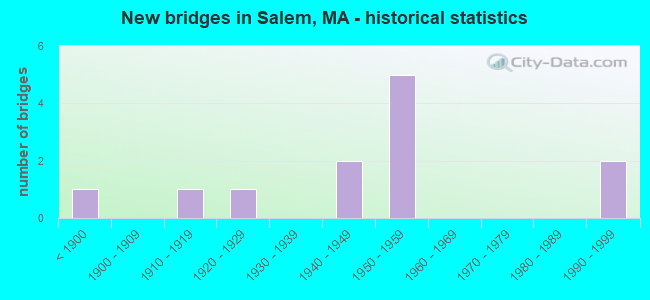
- New bridges - historical statistics
- 1Before 1900
- 11910-1919
- 11920-1929
- 21940-1949
- 51950-1959
- 21990-1999
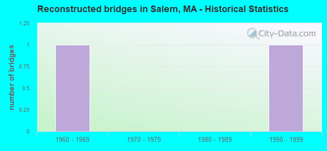
- Reconstructed bridges - Historical Statistics
- 11960-1969
- 01970-1979
- 01980-1989
- 11990-1999
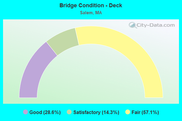
- Bridge Condition - Deck
- 28.6%Good
- 14.3%Satisfactory
- 57.1%Fair
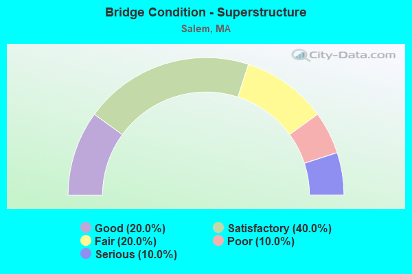
- Bridge Condition - Superstructure
- 20.0%Good
- 40.0%Satisfactory
- 20.0%Fair
- 10.0%Poor
- 10.0%Serious
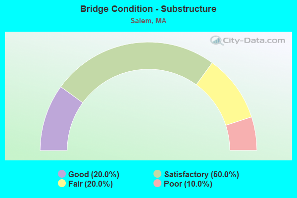
- Bridge Condition - Substructure
- 20.0%Good
- 50.0%Satisfactory
- 20.0%Fair
- 10.0%Poor
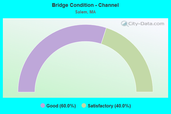
- Bridge Condition - Channel
- 60.0%Good
- 40.0%Satisfactory
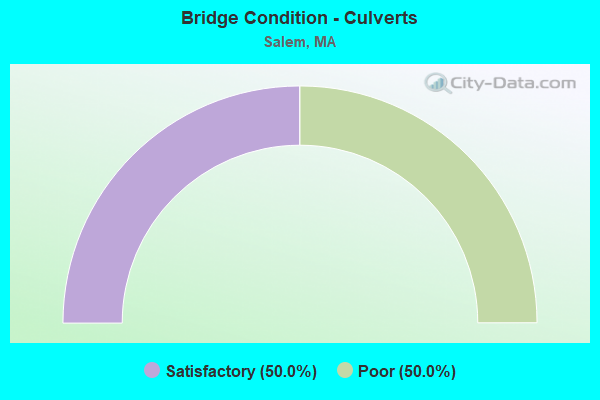
- Bridge Condition - Culverts
- 50.0%Satisfactory
- 50.0%Poor
Find on map >> Show street view
Structure Number: S010012UNDOTNBI, Location: .16 KM N ST107 (Lat: 42.524894, Lng: -70.899281), Route carried "on" structure: State highway 114, Year Built: 1952, Status: Open, Structure Length: 0.73m (2.40ft), Average Daily Traffic: 30,550 (year 2019), Truck Traffic: 9%, Average Future Daily Traffic: 81,650 (year 2032), Design Load: H 20, Features Intersected: WATER NORTH RIVER
Minimum Vertical Clearance: 30+ m (98+ ft), Kilometerpoint: 30.339, Lanes on structure: 4, Base Highway Network: Yes, Owner: State Highway Agency, Approaching Roadway Width: 18.3m (60.0ft), Material/Design: Concrete, Design/Construction: Culvert, Number Of Spans In Main Unit: 2, Length of Maximum Span: 3.7m (12.1ft), Curb or Sidewalk Widths: Left: 1.5m (4.9ft), Right: 1.5m (4.9ft)
Condition: Channel: Good, Culverts: Poor, Inventory Rating: 65.1 metric tons, Method Used To Determine Inventory Rating: Load Factor (LF), Structural Evaluation: Meets minimum limits, Waterway Adequacy: Equal to present minimum criteria, Approach Roadway Alignment: Equal to present desirable criteria, Length Of Structure Improvement: 1.90m (6.23ft), Designated Inspection Frequency: Every 12 months, Underwater Inspection Frequency: Every 12 months, Other Special Inspection Frequency: Every 12 months, Inspection Date: March 2021, Underwater Inspection Date: August 2021, Other Special Inspection Date: March 2021, Bridge Improvement Cost: $545,000, Roadway Improvement Cost: $55,000, Total Project Cost: $818,000 ( Estimate for 2022)
Find on map >> Show street view
Structure Number: S010032QGMUNNBI, Location: AT NORTH RIVER (Lat: 42.521408, Lng: -70.910386), Route carried "on" structure: City street , Year Built: 1950, Status: Open, Structure Length: 0.82m (2.69ft), Average Daily Traffic: 5,818 (year 2019), Truck Traffic: 9%, Average Future Daily Traffic: 6,475 (year 2032), Features Intersected: WATER NORTH RIVER, Facility Carried by Structure: HWY GROVE ST
Minimum Vertical Clearance: 30+ m (98+ ft), Kilometerpoint: 0.048, Lanes on structure: 2, Owner: City or Municipal Highway Agency, Approaching Roadway Width: 11.0m (36.1ft), Skew: 1 degrees, Material/Design: Concrete, Design/Construction: Culvert, Number Of Spans In Main Unit: 3, Length of Maximum Span: 2.4m (7.9ft), Curb or Sidewalk Widths: Left: 1.6m (5.2ft), Right: 1.8m (5.9ft), Curb-To-Curb Width: 11.3m (37.1ft), Out-to-Out Width: 17.9m (58.7ft)
Condition: Channel: Satisfactory, Culverts: Satisfactory, Operating Rating: 42.7 metric tons, Method Used To Determine Operating Rating: Load Factor (LF), Inventory Rating: 25.6 metric tons, Method Used To Determine Inventory Rating: Load Factor (LF), Structural Evaluation: Equal to present minimum criteria, Deck Geometry: Meets minimum limits, Waterway Adequacy: Equal to present desirable criteria, Approach Roadway Alignment: Somewhat better than minimum adequacy, Length Of Structure Improvement: 1.20m (3.94ft), Designated Inspection Frequency: Every 24 months, Inspection Date: July 2021, Bridge Improvement Cost: $380,000, Roadway Improvement Cost: $39,000, Total Project Cost: $571,000 ( Estimate for 2022)
Find on map >> Show street view
Structure Number: S010042QEMUNNBI, Location: AT SOUTH RIVER (Lat: 42.519361, Lng: -70.889742), Route carried "on" structure: City street , Year Built: 1917, Year Reconstructed: 1996, Status: Open, Structure Length: 4.11m (13.48ft), Average Daily Traffic: 12,900 (year 2018), Truck Traffic: 11%, Average Future Daily Traffic: 11,371 (year 2031), Design Load: HS 20, Features Intersected: WATER SOUTH RIVER, Facility Carried by Structure: HWY CONGRESS ST
Minimum Vertical Clearance: 30+ m (98+ ft), Kilometerpoint: 0.483, Lanes on structure: 2, Owner: City or Municipal Highway Agency, Approaching Roadway Width: 13.1m (43.0ft), Skew: 2 degrees, Navigation Control: Yes ( Vertical Clearance: 1.2m (3.9ft), Horizontal Clearance: 13.1m (43.0ft)), Material/Design: Prestressed concrete continuous, Design/Construction: Box Beam or Girders - Multiple, Number Of Spans In Main Unit: 2, Length of Maximum Span: 19.8m (65.0ft), Curb or Sidewalk Widths: Left: 2.9m (9.5ft), Right: 3.0m (9.8ft), Curb-To-Curb Width: 13.1m (43.0ft), Out-to-Out Width: 19.9m (65.3ft)
Condition: Deck: Good, Superstructure: Good, Substructure: Good, Channel: Satisfactory, Operating Rating: 65.3 metric tons, Method Used To Determine Operating Rating: Load Factor (LF), Inventory Rating: 43.0 metric tons, Method Used To Determine Inventory Rating: Load Factor (LF), Structural Evaluation: Better than present minimum criteria, Deck Geometry: Somewhat better than minimum adequacy, Waterway Adequacy: Equal to present desirable criteria, Approach Roadway Alignment: Equal to present desirable criteria, Length Of Structure Improvement: 4.20m (13.78ft), Designated Inspection Frequency: Every 24 months, Underwater Inspection Frequency: Every 36 months, Inspection Date: September 2020, Underwater Inspection Date: May 2021, Bridge Improvement Cost: $119,000, Roadway Improvement Cost: $12,000, Total Project Cost: $179,000 ( Estimate for 2022), Deck Structure Type: Concrete Precast Panels, Wearing Surface/Protective System: Wearing Surface: Bituminous, Membrane: Built-up, Deck Protection: Epoxy Coated Reinforcing
Find on map >> Show street view
Structure Number: S0100531MDOTNBI, Location: 1.8 MI S SALEM CENTER (Lat: 42.496839, Lng: -70.886494), Route carried "on" structure: State highway 114, Year Built: 1898, Year Reconstructed: 1965, Status: Open, Structure Length: 1.58m (5.18ft), Average Daily Traffic: 27,100 (year 2021), Truck Traffic: 1%, Average Future Daily Traffic: 39,956 (year 2032), Design Load: H 20, Features Intersected: WATER FOREST RIVER
Minimum Vertical Clearance: 30+ m (98+ ft), Kilometerpoint: 33.961, Lanes on structure: 2, Base Highway Network: Yes, Owner: State Highway Agency, Approaching Roadway Width: 19.5m (64.0ft), Skew: 1 degrees, Material/Design: Steel, Design/Construction: Stringer/Multi-beam, Number Of Spans In Main Unit: 2, Length of Maximum Span: 8.5m (27.9ft), Curb or Sidewalk Widths: Left: 1.5m (4.9ft), Right: 2.4m (7.9ft), Curb-To-Curb Width: 14.6m (47.9ft), Out-to-Out Width: 19.7m (64.6ft)
Condition: Deck: Fair, Superstructure: Poor, Substructure: Fair, Channel: Good, Operating Rating: 45.2 metric tons, Method Used To Determine Operating Rating: Load Factor (LF), Inventory Rating: 27.1 metric tons, Method Used To Determine Inventory Rating: Load Factor (LF), Structural Evaluation: Meets minimum limits, Deck Geometry: Superior to present desirable criteria, Waterway Adequacy: Superior to present desirable criteria, Approach Roadway Alignment: Equal to present minimum criteria, Length Of Structure Improvement: 2.30m (7.55ft), Designated Inspection Frequency: Every 24 months, Inspection Date: October 2021, Bridge Improvement Cost: $2,229,000, Roadway Improvement Cost: $223,000, Total Project Cost: $3,344,000 ( Estimate for 2022), Deck Structure Type: Concrete Cast-file-Place, Wearing Surface/Protective System: Wearing Surface: Bituminous, Membrane: Built-up
Find on map >> Show street view
Structure Number: S010062QFMUNNBI, Location: .4 MI W OF RTE 1A (Lat: 42.503667, Lng: -70.900586), Route carried "on" structure: City street , Year Built: 1953, Status: Open, Structure Length: 2.32m (7.61ft), Average Daily Traffic: 28,578 (year 2019), Truck Traffic: 3%, Average Future Daily Traffic: 24,479 (year 2032), Design Load: H 20, Features Intersected: RR MBTA/BMRR, Facility Carried by Structure: HWY JEFFRSON AV
Minimum Vertical Clearance: 30+ m (98+ ft), Kilometerpoint: 0.322, Lanes on structure: 2, Owner: City or Municipal Highway Agency, Approaching Roadway Width: 14.3m (46.9ft), Skew: 3 degrees, Material/Design: Steel, Design/Construction: Stringer/Multi-beam, Number Of Spans In Main Unit: 1, Length of Maximum Span: 22.3m (73.2ft), Curb or Sidewalk Widths: Left: 1.6m (5.2ft), Right: 1.6m (5.2ft), Curb-To-Curb Width: 14.0m (45.9ft), Out-to-Out Width: 18.5m (60.7ft)
Condition: Deck: Fair, Superstructure: Satisfactory, Substructure: Satisfactory, Operating Rating: 47.3 metric tons, Method Used To Determine Operating Rating: Load Factor (LF), Inventory Rating: 28.5 metric tons, Method Used To Determine Inventory Rating: Load Factor (LF), Structural Evaluation: Equal to present minimum criteria, Deck Geometry: Superior to present desirable criteria, Underclear: High priority of corrective action, Approach Roadway Alignment: Somewhat better than minimum adequacy, Length Of Structure Improvement: 2.40m (7.87ft), Designated Inspection Frequency: Every 24 months, Inspection Date: September 2021, Bridge Improvement Cost: $1,745,000, Roadway Improvement Cost: $175,000, Total Project Cost: $2,618,000 ( Estimate for 2022), Deck Structure Type: Concrete Cast-file-Place, Wearing Surface/Protective System: Wearing Surface: Bituminous
Find on map >> Show street view
Structure Number: S0100932QDOT634, Location: .1MI W ST 1A (Lat: 42.533139, Lng: -70.890139), Route carried "on" structure: State highway , Year Built: 1994, Status: Open, Structure Length: 2.87m (9.42ft), Average Daily Traffic: 259 (year 2019), Truck Traffic: 50%, Average Future Daily Traffic: 812 (year 2032), Design Load: H 20, Features Intersected: COMB US 1A BYPASS & MBT, Facility Carried by Structure: HWY MARCH ST
Minimum Vertical Clearance: 30+ m (98+ ft), Kilometerpoint: 0.113, Lanes on structure: 2, Lanes under structure: 2, Owner: State Highway Agency, Approaching Roadway Width: 7.9m (25.9ft), Material/Design: Steel, Design/Construction: Stringer/Multi-beam, Number Of Spans In Main Unit: 1, Length of Maximum Span: 26.8m (87.9ft), Curb or Sidewalk Widths: Left: 1.8m (5.9ft), Right: 0.0m, Curb-To-Curb Width: 7.9m (25.9ft), Out-to-Out Width: 10.5m (34.4ft)
Condition: Deck: Good, Superstructure: Good, Substructure: Good, Operating Rating: 97.6 metric tons, Method Used To Determine Operating Rating: Load Factor (LF), Inventory Rating: 58.4 metric tons, Method Used To Determine Inventory Rating: Load Factor (LF), Structural Evaluation: Better than present minimum criteria, Deck Geometry: Somewhat better than minimum adequacy, Underclear: Meets minimum limits, Approach Roadway Alignment: Equal to present minimum criteria, Length Of Structure Improvement: 2.90m (9.51ft), Designated Inspection Frequency: Every 24 months, Inspection Date: September 2021, Bridge Improvement Cost: $848,000, Roadway Improvement Cost: $85,000, Total Project Cost: $1,273,000 ( Estimate for 2022), Deck Structure Type: Concrete Cast-file-Place, Wearing Surface/Protective System: Wearing Surface: Latex Concrete, Deck Protection: Epoxy Coated Reinforcing
Find on map >> Show street view
Structure Number: S0101732RDOT634, Location: .32 KM N SALEM CENTER (Lat: 42.523883, Lng: -70.895994), Route carried "on" structure: State highway 107, Year Built: 1949, Status: Open, Structure Length: 5.79m (19.00ft), Average Daily Traffic: 24,000 (year 2017), Truck Traffic: 8%, Average Future Daily Traffic: 27,638 (year 2032), Design Load: H 20, Features Intersected: RR MBTA (STORAGE TUN)
Minimum Vertical Clearance: 30+ m (98+ ft), Kilometerpoint: 17.686, Lanes on structure: 2, Base Highway Network: Yes, Owner: State Highway Agency, Approaching Roadway Width: 11.9m (39.0ft), Skew: 3 degrees, Material/Design: Concrete, Design/Construction: Frame, Number Of Spans In Main Unit: 1, Length of Maximum Span: 19.8m (65.0ft), Curb or Sidewalk Widths: Left: 1.8m (5.9ft), Right: 0.0m, Curb-To-Curb Width: 89.0m (292.0ft), Out-to-Out Width: 93.0m (305.1ft)
Condition: Superstructure: Satisfactory, Substructure: Satisfactory, Operating Rating: 79.8 metric tons, Method Used To Determine Operating Rating: Load Factor (LF), Inventory Rating: 48.7 metric tons, Method Used To Determine Inventory Rating: Load Factor (LF), Structural Evaluation: Equal to present minimum criteria, Deck Geometry: Superior to present desirable criteria, Underclear: Meets minimum limits, Approach Roadway Alignment: Better than present minimum criteria, Length Of Structure Improvement: 5.80m (19.03ft), Designated Inspection Frequency: Every 24 months, Inspection Date: December 2021, Bridge Improvement Cost: $4,238,000, Roadway Improvement Cost: $424,000, Total Project Cost: $6,358,000 ( Estimate for 2022)
Find on map >> Show street view
Structure Number: S0101732VDOT634, Location: .32 KM N SALEM CENTER (Lat: 42.524283, Lng: -70.898681), Route carried "on" structure: State highway 107, Year Built: 1949, Status: Open, Structure Length: 1.10m (3.61ft), Average Daily Traffic: 24,000 (year 2017), Truck Traffic: 8%, Average Future Daily Traffic: 27,638 (year 2032), Design Load: H 20, Features Intersected: RR MBTA (MAIN LINE)
Minimum Vertical Clearance: 30+ m (98+ ft), Kilometerpoint: 17.686, Lanes on structure: 2, Base Highway Network: Yes, Owner: State Highway Agency, Approaching Roadway Width: 11.9m (39.0ft), Skew: 1 degrees, Material/Design: Concrete, Design/Construction: Frame, Number Of Spans In Main Unit: 1, Length of Maximum Span: 7.3m (24.0ft), Curb or Sidewalk Widths: Left: 1.8m (5.9ft), Right: 0.0m, Curb-To-Curb Width: 34.3m (112.5ft), Out-to-Out Width: 36.1m (118.4ft)
Condition: Superstructure: Satisfactory, Substructure: Satisfactory, Operating Rating: 59.1 metric tons, Method Used To Determine Operating Rating: Load Factor (LF), Inventory Rating: 35.4 metric tons, Method Used To Determine Inventory Rating: Load Factor (LF), Structural Evaluation: Equal to present minimum criteria, Deck Geometry: Superior to present desirable criteria, Underclear: Meets minimum limits, Approach Roadway Alignment: Better than present minimum criteria, Length Of Structure Improvement: 1.20m (3.94ft), Designated Inspection Frequency: Every 24 months, Inspection Date: December 2021, Bridge Improvement Cost: $341,000, Roadway Improvement Cost: $35,000, Total Project Cost: $512,000 ( Estimate for 2022)
Find on map >> Show street view
Structure Number: S0101832TDOT634, Location: .1 MI W SALEM CENTER (Lat: 42.524147, Lng: -70.898800), Route carried "on" structure: State highway 114, Year Built: 1952, Status: Posted for load, Structure Length: 4.21m (13.81ft), Average Daily Traffic: 39,520 (year 2016), Truck Traffic: 10%, Average Future Daily Traffic: 51,169 (year 2031), Features Intersected: COMB ST107/BRG ST&MBTA
Minimum Vertical Clearance: 30+ m (98+ ft), Kilometerpoint: 30.442, Lanes on structure: 4, Lanes under structure: 2, Base Highway Network: Yes, Owner: State Highway Agency, Approaching Roadway Width: 22.9m (75.1ft), Skew: 21 degrees, Material/Design: Steel, Design/Construction: Stringer/Multi-beam, Number Of Spans In Main Unit: 3, Length of Maximum Span: 20.1m (65.9ft), Curb or Sidewalk Widths: Left: 1.9m (6.2ft), Right: 1.9m (6.2ft), Curb-To-Curb Width: 18.3m (60.0ft), Out-to-Out Width: 22.1m (72.5ft)
Condition: Deck: Fair, Superstructure: Fair, Substructure: Fair, Operating Rating: 40.9 metric tons, Method Used To Determine Operating Rating: Allowable Stress (AS), Inventory Rating: 21.9 metric tons, Method Used To Determine Inventory Rating: Allowable Stress (AS), Structural Evaluation: Somewhat better than minimum adequacy, Deck Geometry: Somewhat better than minimum adequacy, Underclear: High priority of corrective action, Approach Roadway Alignment: Equal to present minimum criteria, Length Of Structure Improvement: 4.30m (14.11ft), Designated Inspection Frequency: Every 24 months, Inspection Date: September 2020, Bridge Improvement Cost: $3,733,000, Roadway Improvement Cost: $374,000, Total Project Cost: $5,600,000 ( Estimate for 2022), Deck Structure Type: Concrete Cast-file-Place, Wearing Surface/Protective System: Wearing Surface: Bituminous, Membrane: Built-up
Find on map >> Show street view
Structure Number: S0101932UDOT634, Location: DOWN TOWN SALEM (Lat: 42.523908, Lng: -70.895969), Route carried "on" structure: State highway , Year Built: 1955, Status: Open, Structure Length: 1.10m (3.61ft), Average Daily Traffic: 32,000 (year 2015), Truck Traffic: 6%, Average Future Daily Traffic: 43,431 (year 2032), Design Load: H 20, Features Intersected: RR MBTA (TUNNEL), Facility Carried by Structure: ST114 /WASHINGTON
Minimum Vertical Clearance: 30+ m (98+ ft), Kilometerpoint: 0.002, Lanes on structure: 2, Base Highway Network: Yes, Owner: State Highway Agency, Approaching Roadway Width: 12.8m (42.0ft), Material/Design: Steel, Design/Construction: Frame, Number Of Spans In Main Unit: 1, Length of Maximum Span: 9.8m (32.2ft), Curb or Sidewalk Widths: Left: 3.4m (11.2ft), Right: 3.4m (11.2ft), Curb-To-Curb Width: 304.8m (1,000.0ft), Out-to-Out Width: 304.8m (1,000.0ft)
Condition: Superstructure: Satisfactory, Substructure: Satisfactory, Operating Rating: 62.1 metric tons, Method Used To Determine Operating Rating: Load Factor (LF), Inventory Rating: 37.2 metric tons, Method Used To Determine Inventory Rating: Load Factor (LF), Structural Evaluation: Equal to present minimum criteria, Deck Geometry: Superior to present desirable criteria, Underclear: High priority of corrective action, Approach Roadway Alignment: Better than present minimum criteria, Length Of Structure Improvement: 1.20m (3.94ft), Designated Inspection Frequency: Every 24 months, Inspection Date: December 2021, Bridge Improvement Cost: $2,874,000, Roadway Improvement Cost: $288,000, Total Project Cost: $4,312,000 ( Estimate for 2022)
Find on map >> Show street view
Structure Number: S01021AV1MUNNBI, Location: .4 MI SW. OF RT114 (Lat: 42.521325, Lng: -70.905872), Route carried "on" structure: City street , Year Built: 1998, Status: Open, Structure Length: 1.38m (4.53ft), Average Daily Traffic: 12,900 (year 2018), Truck Traffic: 9%, Average Future Daily Traffic: 12,476 (year 2031), Design Load: HS 20, Features Intersected: WATER NORTH RIVER CANAL, Facility Carried by Structure: HWY FLINT ST
Minimum Vertical Clearance: 30+ m (98+ ft), Kilometerpoint: 0.547, Lanes on structure: 3, Owner: City or Municipal Highway Agency, Approaching Roadway Width: 11.0m (36.1ft), Material/Design: Prestressed concrete, Design/Construction: Box Beam or Girders - Multiple, Number Of Spans In Main Unit: 1, Length of Maximum Span: 13.8m (45.3ft), Curb or Sidewalk Widths: Left: 0.3m (1.0ft), Right: 0.3m (1.0ft), Curb-To-Curb Width: 12.2m (40.0ft), Out-to-Out Width: 36.8m (120.7ft)
Condition: Deck: Fair, Superstructure: Fair, Substructure: Satisfactory, Channel: Good, Operating Rating: 54.3 metric tons, Method Used To Determine Operating Rating: Load Factor (LF), Inventory Rating: 37.1 metric tons, Method Used To Determine Inventory Rating: Load Factor (LF), Structural Evaluation: Somewhat better than minimum adequacy, Deck Geometry: Meets minimum limits, Waterway Adequacy: Somewhat better than minimum adequacy, Approach Roadway Alignment: Better than present minimum criteria, Length Of Structure Improvement: 1.40m (4.59ft), Designated Inspection Frequency: Every 24 months, Inspection Date: July 2020, Bridge Improvement Cost: $2,024,000, Roadway Improvement Cost: $203,000, Total Project Cost: $3,037,000 ( Estimate for 2022), Deck Structure Type: Concrete Precast Panels, Wearing Surface/Protective System: Wearing Surface: Bituminous, Membrane: Built-up, Deck Protection: Epoxy Coated Reinforcing
Find on map >> Show street view
Structure Number: S010242QHMUNNBI, Location: NEXT TO MBTA (Lat: 42.503133, Lng: -70.900097), Route carried "on" structure: City street , Year Built: 1920, Status: Open, Structure Length: 0.76m (2.49ft), Average Daily Traffic: 35,900 (year 2018), Truck Traffic: 2%, Average Future Daily Traffic: 20,847 (year 2033), Features Intersected: HWY PARALLEL ST, Facility Carried by Structure: HWY JEFFRSON AV
Minimum Vertical Clearance: 30+ m (98+ ft), Kilometerpoint: 0.483, Lanes on structure: 2, Lanes under structure: 2, Owner: City or Municipal Highway Agency, Approaching Roadway Width: 14.0m (45.9ft), Skew: 3 degrees, Material/Design: Steel, Design/Construction: Stringer/Multi-beam, Number Of Spans In Main Unit: 1, Length of Maximum Span: 6.4m (21.0ft), Curb or Sidewalk Widths: Left: 1.7m (5.6ft), Right: 2.0m (6.6ft), Curb-To-Curb Width: 14.1m (46.3ft), Out-to-Out Width: 18.1m (59.4ft)
Condition: Deck: Satisfactory, Superstructure: Serious, Substructure: Poor, Operating Rating: 63.7 metric tons, Method Used To Determine Operating Rating: Load Factor (LF), Inventory Rating: 38.1 metric tons, Method Used To Determine Inventory Rating: Load Factor (LF), Structural Evaluation: High priority of corrective action, Deck Geometry: Superior to present desirable criteria, Underclear: High priority of corrective action, Approach Roadway Alignment: Somewhat better than minimum adequacy, Length Of Structure Improvement: 0.80m (2.62ft), Designated Inspection Frequency: Every 6 months, Other Special Inspection Frequency: Every 6 months, Inspection Date: January 2022, Other Special Inspection Date: January 2022, Bridge Improvement Cost: $569,000, Roadway Improvement Cost: $57,000, Total Project Cost: $854,000 ( Estimate for 2022), Deck Structure Type: Concrete Cast-file-Place, Wearing Surface/Protective System: Wearing Surface: Bituminous