Bridge Statistics for Salem, Missouri (MO)
Condition, Traffic, Stress, Structural Evaluation, Project Costs
- National Bridge Inventory (NBI) Statistics
- 11Number of bridges
- 66ft / 20.5mTotal length
- $728,000Total costs
- 22,828Total average daily traffic
- 2,428Total average daily truck traffic
- 33,804Total future (year 2041) average daily traffic
- National Bridge Inventory (NBI) Registered Bridges for Salem
- No street view available for this location
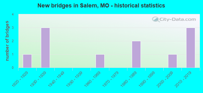
- New bridges - historical statistics
- 11920-1929
- 31930-1939
- 11960-1969
- 21980-1989
- 12000-2009
- 32010-2019


- Bridge Condition - Deck
- 16.7%Very good
- 50.0%Good
- 16.7%Satisfactory
- 16.7%Poor

- Bridge Condition - Superstructure
- 28.6%Excellent
- 42.9%Good
- 28.6%Fair

- Bridge Condition - Substructure
- 28.6%Excellent
- 14.3%Good
- 28.6%Satisfactory
- 28.6%Fair

- Bridge Condition - Channel
- 9.1%Very good
- 36.4%Good
- 36.4%Satisfactory
- 18.2%Fair

- Bridge Condition - Culverts
- 25.0%Very good
- 75.0%Satisfactory
Find on map >> Show street view
Structure Number: 19811, Location: S 18 T 34 N R 5 W (Lat: 37.651400, Lng: -91.528800), Route carried "on" structure: County highway 235, Year Built: 1989, Status: Open, Structure Length: 1.98m (6.50ft), Average Daily Traffic: 250 (year 2021), Truck Traffic: 10%, Average Future Daily Traffic: 300 (year 2041), Design Load: H 20, Features Intersected: SPRING CR, Facility Carried by Structure: 10TH STREET
Minimum Vertical Clearance: 30+ m (98+ ft), Kilometerpoint: 0.161, Lanes on structure: 2, Owner: City or Municipal Highway Agency, Approaching Roadway Width: 8.5m (27.9ft), Material/Design: Prestressed concrete, Design/Construction: Stringer/Multi-beam, Number Of Spans In Main Unit: 1, Length of Maximum Span: 19.2m (63.0ft), Curb or Sidewalk Widths: Left: 0.2m (0.7ft), Right: 0.2m (0.7ft), Curb-To-Curb Width: 7.3m (24.0ft), Out-to-Out Width: 8.1m (26.6ft)
Condition: Deck: Satisfactory, Superstructure: Good, Substructure: Satisfactory, Channel: Fair, Operating Rating: 49.5 metric tons, Method Used To Determine Operating Rating: Allowable Stress (AS), Inventory Rating: 32.4 metric tons, Method Used To Determine Inventory Rating: Allowable Stress (AS), Structural Evaluation: Equal to present minimum criteria, Deck Geometry: Somewhat better than minimum adequacy, Waterway Adequacy: Equal to present desirable criteria, Approach Roadway Alignment: Equal to present minimum criteria, Designated Inspection Frequency: Every 24 months, Inspection Date: Febuary 2021, Deck Structure Type: Concrete Cast-file-Place, Wearing Surface/Protective System: Wearing Surface: Monolithic Concrete
Find on map >> Show street view
Structure Number: 23097, Location: S 18 T 34 N R 5 W (Lat: 37.644300, Lng: -91.534100), Route carried "on" structure: City street , Year Built: 1925, Status: Open, Structure Length: 0.67m (2.20ft), Average Daily Traffic: 200 (year 2021), Truck Traffic: 10%, Average Future Daily Traffic: 240 (year 2041), Features Intersected: CREEK, Facility Carried by Structure: EAST 2ND STREET
Minimum Vertical Clearance: 30+ m (98+ ft), Kilometerpoint: 0.161, Lanes on structure: 1, Owner: City or Municipal Highway Agency, Approaching Roadway Width: 7.9m (25.9ft), Material/Design: Concrete, Design/Construction: Arch - Deck, Number Of Spans In Main Unit: 1, Length of Maximum Span: 6.7m (22.0ft), Curb-To-Curb Width: 4.0m (13.1ft), Out-to-Out Width: 4.4m (14.4ft)
Condition: Superstructure: Fair, Substructure: Fair, Channel: Fair, Operating Rating: 49.5 metric tons, Method Used To Determine Operating Rating: Allowable Stress (AS), Inventory Rating: 16.2 metric tons, Method Used To Determine Inventory Rating: Allowable Stress (AS), Structural Evaluation: Somewhat better than minimum adequacy, Deck Geometry: High priority of replacement, Waterway Adequacy: Better than present minimum criteria, Approach Roadway Alignment: Equal to present minimum criteria, Length Of Structure Improvement: 0.13m (0.43ft), Designated Inspection Frequency: Every 24 months, Inspection Date: Febuary 2021, Bridge Improvement Cost: $95,000, Roadway Improvement Cost: $10,000, Total Project Cost: $143,000 ( Estimate for 2022)
Find on map >> Show street view
Structure Number: 30895, Location: S 14 T 34 N R 6 W (Lat: 37.650908, Lng: -91.563200), Route carried "on" structure: State highway 72, Year Built: 2005, Status: Open, Structure Length: 0.83m (2.72ft), Average Daily Traffic: 5,036 (year 2021), Truck Traffic: 11%, Average Future Daily Traffic: 7,554 (year 2041), Design Load: HS 20, Features Intersected: BUNKER CR
Minimum Vertical Clearance: 30+ m (98+ ft), Kilometerpoint: 40.765, Lanes on structure: 3, Base Highway Network: Yes, Owner: State Highway Agency, Approaching Roadway Width: 19.5m (64.0ft), Skew: 4 degrees, Material/Design: Concrete continuous, Design/Construction: Culvert, Number Of Spans In Main Unit: 2, Length of Maximum Span: 3.0m (9.8ft)
Condition: Channel: Satisfactory, Culverts: Very good, Operating Rating: 71.1 metric tons, Method Used To Determine Operating Rating: Load Factor (LF), Inventory Rating: 43.2 metric tons, Method Used To Determine Inventory Rating: Load Factor (LF), Structural Evaluation: Equal to present desirable criteria, Waterway Adequacy: Superior to present desirable criteria, Approach Roadway Alignment: Equal to present desirable criteria, Designated Inspection Frequency: Every 24 months, Inspection Date: Febuary 2022
Find on map >> Show street view
Structure Number: 34008, Location: S 19 T 34 N R 5 W (Lat: 37.635200, Lng: -91.518500), Route carried "on" structure: State highway 32, Year Built: 2012, Status: Open, Structure Length: 4.20m (13.78ft), Average Daily Traffic: 4,644 (year 2021), Truck Traffic: 10%, Average Future Daily Traffic: 6,966 (year 2041), Design Load: HS 20, Features Intersected: SPRING CR
Minimum Vertical Clearance: 30+ m (98+ ft), Kilometerpoint: 282.489, Lanes on structure: 2, Base Highway Network: Yes, Owner: State Highway Agency, Approaching Roadway Width: 9.8m (32.2ft), Material/Design: Prestressed concrete, Design/Construction: Box Beam or Girders - Single/Spread, Number Of Spans In Main Unit: 3, Length of Maximum Span: 16.8m (55.1ft), Curb-To-Curb Width: 9.8m (32.2ft), Out-to-Out Width: 10.4m (34.1ft)
Condition: Deck: Good, Superstructure: Excellent, Substructure: Satisfactory, Channel: Very good, Operating Rating: 90.9 metric tons, Method Used To Determine Operating Rating: Load Factor (LF), Inventory Rating: 54.0 metric tons, Method Used To Determine Inventory Rating: Load Factor (LF), Structural Evaluation: Equal to present minimum criteria, Deck Geometry: Meets minimum limits, Waterway Adequacy: Superior to present desirable criteria, Approach Roadway Alignment: Equal to present desirable criteria, Designated Inspection Frequency: Every 24 months, Inspection Date: Febuary 2022, Deck Structure Type: Concrete Cast-file-Place, Wearing Surface/Protective System: Wearing Surface: Monolithic Concrete, Deck Protection: Epoxy Coated Reinforcing
Find on map >> Show street view
Structure Number: 347, Location: S 2 T 34 N R 6 W (Lat: 37.696944, Lng: -91.572222), Route carried "on" structure: County highway 217, Year Built: 2014, Status: Open, Structure Length: 2.74m (8.99ft), Average Daily Traffic: 50 (year 2021), Truck Traffic: 10%, Average Future Daily Traffic: 60 (year 2041), Design Load: HS 20, Features Intersected: SPRING CR, Facility Carried by Structure: COUNTY RD 3210
Minimum Vertical Clearance: 30+ m (98+ ft), Kilometerpoint: 0.805, Lanes on structure: 2, Owner: County Highway Agency, Approaching Roadway Width: 7.3m (24.0ft), Material/Design: Prestressed concrete, Design/Construction: Tee Beam, Number Of Spans In Main Unit: 1, Length of Maximum Span: 26.2m (86.0ft), Curb-To-Curb Width: 7.3m (24.0ft), Out-to-Out Width: 7.5m (24.6ft)
Condition: Deck: Very good, Superstructure: Excellent, Substructure: Excellent, Channel: Satisfactory, Operating Rating: 66.6 metric tons, Method Used To Determine Operating Rating: Load Factor (LF), Inventory Rating: 35.1 metric tons, Method Used To Determine Inventory Rating: Load Factor (LF), Structural Evaluation: Superior to present desirable criteria, Deck Geometry: Equal to present minimum criteria, Waterway Adequacy: Better than present minimum criteria, Approach Roadway Alignment: Equal to present desirable criteria, Designated Inspection Frequency: Every 24 months, Inspection Date: Febuary 2021, Deck Structure Type: Concrete Cast-file-Place, Wearing Surface/Protective System: Wearing Surface: Monolithic Concrete
Find on map >> Show street view
Structure Number: 35725, Location: S 32 T 34 N R 6 W (Lat: 37.607736, Lng: -91.609556), Route carried "on" structure: State highway F, Year Built: 2018, Status: Open, Structure Length: 3.20m (10.50ft), Average Daily Traffic: 623 (year 2021), Truck Traffic: 13%, Average Future Daily Traffic: 872 (year 2041), Features Intersected: HOLT CR
Minimum Vertical Clearance: 30+ m (98+ ft), Kilometerpoint: 1.165, Lanes on structure: 2, Owner: State Highway Agency, Approaching Roadway Width: 7.3m (24.0ft), Skew: 3 degrees, Material/Design: Prestressed concrete, Design/Construction: Tee Beam, Number Of Spans In Main Unit: 3, Length of Maximum Span: 11.3m (37.1ft), Curb-To-Curb Width: 7.3m (24.0ft), Out-to-Out Width: 8.1m (26.6ft)
Condition: Deck: Good, Superstructure: Good, Substructure: Excellent, Channel: Good, Operating Rating: 78.3 metric tons, Method Used To Determine Operating Rating: Load Factor (LF), Inventory Rating: 46.8 metric tons, Method Used To Determine Inventory Rating: Load Factor (LF), Structural Evaluation: Better than present minimum criteria, Deck Geometry: Meets minimum limits, Waterway Adequacy: Superior to present desirable criteria, Approach Roadway Alignment: Equal to present desirable criteria, Designated Inspection Frequency: Every 24 months, Inspection Date: Febuary 2022, Deck Structure Type: Concrete Cast-file-Place, Wearing Surface/Protective System: Wearing Surface: Monolithic Concrete, Deck Protection: Epoxy Coated Reinforcing
Find on map >> Show street view
Structure Number: 3621, Location: S 24 T 34 N R 6 W (Lat: 37.626092, Lng: -91.535631), Route carried "on" structure: State highway 19, Year Built: 1986, Status: Open, Structure Length: 2.07m (6.79ft), Average Daily Traffic: 4,944 (year 2021), Truck Traffic: 10%, Average Future Daily Traffic: 7,416 (year 2041), Design Load: HS 20, Features Intersected: SPRING FK
Minimum Vertical Clearance: 30+ m (98+ ft), Kilometerpoint: 268.808, Lanes on structure: 2, Base Highway Network: Yes, Owner: State Highway Agency, Approaching Roadway Width: 13.4m (44.0ft), Skew: 2 degrees, Material/Design: Prestressed concrete continuous, Design/Construction: Tee Beam, Number Of Spans In Main Unit: 3, Length of Maximum Span: 6.9m (22.6ft), Curb or Sidewalk Widths: Left: 0.2m (0.7ft), Right: 0.2m (0.7ft), Curb-To-Curb Width: 13.0m (42.7ft), Out-to-Out Width: 13.9m (45.6ft)
Condition: Deck: Good, Superstructure: Good, Substructure: Good, Channel: Good, Operating Rating: 76.5 metric tons, Method Used To Determine Operating Rating: Allowable Stress (AS), Inventory Rating: 52.2 metric tons, Method Used To Determine Inventory Rating: Allowable Stress (AS), Structural Evaluation: Better than present minimum criteria, Deck Geometry: Equal to present minimum criteria, Waterway Adequacy: Equal to present minimum criteria, Approach Roadway Alignment: Equal to present desirable criteria, Designated Inspection Frequency: Every 24 months, Inspection Date: Febuary 2022, Deck Structure Type: Concrete Cast-file-Place, Wearing Surface/Protective System: Wearing Surface: Bituminous, Deck Protection: Epoxy Coated Reinforcing
Find on map >> Show street view
Structure Number: 4479, Location: S 28 T 34 N R 6 W (Lat: 37.620828, Lng: -91.603958), Route carried "on" structure: State highway 32, Year Built: 1964, Status: Open, Structure Length: 0.74m (2.43ft), Average Daily Traffic: 2,902 (year 2021), Truck Traffic: 12%, Average Future Daily Traffic: 4,353 (year 2041), Design Load: H 20, Features Intersected: E FK HOLT CR
Minimum Vertical Clearance: 30+ m (98+ ft), Kilometerpoint: 274.469, Lanes on structure: 2, Base Highway Network: Yes, Owner: State Highway Agency, Approaching Roadway Width: 6.7m (22.0ft), Skew: 2 degrees, Material/Design: Concrete continuous, Design/Construction: Culvert, Number Of Spans In Main Unit: 2, Length of Maximum Span: 3.4m (11.2ft)
Condition: Channel: Good, Culverts: Satisfactory, Inventory Rating: 68.4 metric tons, Method Used To Determine Inventory Rating: Load Factor (LF), Structural Evaluation: Equal to present minimum criteria, Waterway Adequacy: Equal to present desirable criteria, Approach Roadway Alignment: Equal to present desirable criteria, Designated Inspection Frequency: Every 24 months, Inspection Date: Febuary 2022
Find on map >> Show street view
Structure Number: 5316, Location: S 22 T 34 N R 5 W (Lat: 37.637072, Lng: -91.480275), Route carried "on" structure: State highway 32, Year Built: 1931, Status: Open, Structure Length: 0.76m (2.49ft), Average Daily Traffic: 1,919 (year 2021), Truck Traffic: 10%, Average Future Daily Traffic: 2,879 (year 2041), Design Load: H 15, Features Intersected: MORRIS BR
Minimum Vertical Clearance: 30+ m (98+ ft), Kilometerpoint: 169.026, Lanes on structure: 2, Base Highway Network: Yes, Owner: State Highway Agency, Approaching Roadway Width: 9.1m (29.9ft), Material/Design: Concrete continuous, Design/Construction: Culvert, Number Of Spans In Main Unit: 2, Length of Maximum Span: 3.7m (12.1ft), Curb-To-Curb Width: 10.4m (34.1ft), Out-to-Out Width: 11.0m (36.1ft)
Condition: Channel: Good, Culverts: Satisfactory, Inventory Rating: 68.4 metric tons, Method Used To Determine Inventory Rating: Load Factor (LF), Structural Evaluation: Equal to present minimum criteria, Deck Geometry: Equal to present minimum criteria, Waterway Adequacy: Equal to present desirable criteria, Approach Roadway Alignment: Equal to present minimum criteria, Designated Inspection Frequency: Every 24 months, Inspection Date: Febuary 2022
Find on map >> Show street view
Structure Number: 8907, Location: S 12 T 34 N R 6 W (Lat: 37.661400, Lng: -91.535508), Route carried "on" structure: State highway 68, Year Built: 1933, Status: Open, Structure Length: 0.76m (2.49ft), Average Daily Traffic: 1,666 (year 2021), Truck Traffic: 11%, Average Future Daily Traffic: 2,332 (year 2041), Design Load: H 10, Features Intersected: SPRING BR
Minimum Vertical Clearance: 30+ m (98+ ft), Kilometerpoint: 62.810, Lanes on structure: 2, Owner: State Highway Agency, Approaching Roadway Width: 7.3m (24.0ft), Skew: 1 degrees, Material/Design: Concrete continuous, Design/Construction: Culvert, Number Of Spans In Main Unit: 2, Length of Maximum Span: 3.7m (12.1ft), Curb-To-Curb Width: 8.2m (26.9ft), Out-to-Out Width: 8.8m (28.9ft)
Condition: Channel: Satisfactory, Culverts: Satisfactory, Operating Rating: 38.7 metric tons, Method Used To Determine Operating Rating: Load Factor (LF), Inventory Rating: 22.5 metric tons, Method Used To Determine Inventory Rating: Load Factor (LF), Structural Evaluation: Equal to present minimum criteria, Deck Geometry: Meets minimum limits, Waterway Adequacy: Equal to present desirable criteria, Approach Roadway Alignment: Equal to present desirable criteria, Designated Inspection Frequency: Every 24 months, Inspection Date: Febuary 2022
Find on map >> Show street view
Structure Number: 9382, Location: S 9 T 33 N R 5 W (Lat: 37.575736, Lng: -91.482322), Route carried "on" structure: State highway B, Year Built: 1939, Year Reconstructed: 1994, Status: Posted for load, Structure Length: 2.53m (8.30ft), Average Daily Traffic: 594 (year 2021), Truck Traffic: 11%, Average Future Daily Traffic: 832 (year 2041), Design Load: H 10, Features Intersected: DRY CREEK
Minimum Vertical Clearance: 30+ m (98+ ft), Kilometerpoint: 3.993, Lanes on structure: 2, Owner: State Highway Agency, Approaching Roadway Width: 6.1m (20.0ft), Skew: 2 degrees, Material/Design: Steel, Design/Construction: Stringer/Multi-beam, Number Of Spans In Main Unit: 3, Length of Maximum Span: 8.3m (27.2ft), Curb-To-Curb Width: 6.7m (22.0ft), Out-to-Out Width: 7.1m (23.3ft)
Condition: Deck: Poor, Superstructure: Fair, Substructure: Fair, Channel: Satisfactory, Operating Rating: 27.9 metric tons, Method Used To Determine Operating Rating: Allowable Stress (AS), Inventory Rating: 18.0 metric tons, Method Used To Determine Inventory Rating: Allowable Stress (AS), Structural Evaluation: Somewhat better than minimum adequacy, Deck Geometry: Meets minimum limits, Waterway Adequacy: Equal to present desirable criteria, Approach Roadway Alignment: Equal to present minimum criteria, Bridge Posting: Required (Relationship of Operating Rating to Maximum Legal Load: 20.0 - 29.9% below), Length Of Structure Improvement: 0.34m (1.12ft), Designated Inspection Frequency: Every 24 months, Inspection Date: Febuary 2022, Bridge Improvement Cost: $390,000, Roadway Improvement Cost: $39,000, Total Project Cost: $585,000 ( Estimate for 2022), Deck Structure Type: Concrete Cast-file-Place, Wearing Surface/Protective System: Wearing Surface: Bituminous, Membrane: Built-up