Bridge Statistics for Salina, Utah (UT)
Condition, Traffic, Stress, Structural Evaluation, Project Costs
- National Bridge Inventory (NBI) Statistics
- 20Number of bridges
- 98ft / 30.0mTotal length
- 92,295Total average daily traffic
- 32,821Total average daily truck traffic
- National Bridge Inventory (NBI) Registered Bridges for Salina
- No street view available for this location
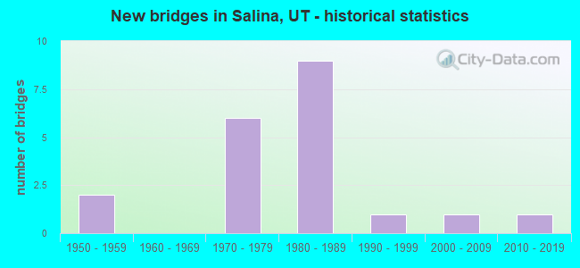
- New bridges - historical statistics
- 21950-1959
- 61970-1979
- 91980-1989
- 11990-1999
- 12000-2009
- 12010-2019


- Bridge Condition - Deck
- 22.2%Good
- 77.8%Satisfactory

- Bridge Condition - Superstructure
- 22.2%Very good
- 44.4%Good
- 33.3%Satisfactory

- Bridge Condition - Substructure
- 33.3%Good
- 66.7%Satisfactory

- Bridge Condition - Channel
- 10.0%Very good
- 50.0%Good
- 40.0%Satisfactory

- Bridge Condition - Culverts
- 14.3%Very good
- 57.1%Good
- 28.6%Satisfactory
Find on map >> Show street view
Structure Number: 41027F, Location: 3 MILES SW. OF SALINA (Lat: 38.925428, Lng: -111.897556), Route carried "on" structure: County highway , Year Built: 1997, Status: Open, Structure Length: 1.83m (6.00ft), Average Daily Traffic: 95 (year 2020), Truck Traffic: 20%, Average Future Daily Traffic: 115 (year 2040), Design Load: HS 20+Mod, Features Intersected: SEVIER RIVER, Facility Carried by Structure: COUNTY ROAD
Minimum Vertical Clearance: 30+ m (98+ ft), Kilometerpoint: 0.396, Lanes on structure: 2, Owner: County Highway Agency, Approaching Roadway Width: 8.7m (28.5ft), Material/Design: Prestressed concrete, Design/Construction: Tee Beam, Number Of Spans In Main Unit: 1, Length of Maximum Span: 17.7m (58.1ft), Curb-To-Curb Width: 8.7m (28.5ft), Out-to-Out Width: 9.7m (31.8ft)
Condition: Deck: Good, Superstructure: Satisfactory, Substructure: Good, Channel: Very good, Operating Rating: 32.4 metric tons, Method Used To Determine Operating Rating: Load and Resistance Factor Rating (LRFR) rating reported by rating factor(RF) method using HL-93 loadings, Inventory Rating: 22.7 metric tons, Method Used To Determine Inventory Rating: Load Factor (LF) rating reported by rating factor (RF) method using MS18 loading, Structural Evaluation: Equal to present minimum criteria, Deck Geometry: Better than present minimum criteria, Waterway Adequacy: Equal to present desirable criteria, Approach Roadway Alignment: Equal to present desirable criteria, Designated Inspection Frequency: Every 24 months, Inspection Date: July 2020, Deck Structure Type: Concrete Precast Panels, Wearing Surface/Protective System: Wearing Surface: Monolithic Concrete
Find on map >> Show street view
Structure Number: 41028E, Location: 2 MILES WEST OF SALINA (Lat: 38.952867, Lng: -111.899286), Route carried "on" structure: County highway , Year Built: 2004, Status: Open, Structure Length: 0.70m (2.30ft), Average Daily Traffic: 63 (year 2020), Truck Traffic: 1%, Average Future Daily Traffic: 77 (year 2040), Design Load: HS 20+Mod, Features Intersected: DENMARK WASH, Facility Carried by Structure: COUNTY ROAD
Minimum Vertical Clearance: 30+ m (98+ ft), Kilometerpoint: 0.775, Lanes on structure: 2, Owner: County Highway Agency, Approaching Roadway Width: 7.3m (24.0ft), Skew: 1 degrees, Material/Design: Concrete, Design/Construction: Culvert, Number Of Spans In Main Unit: 1, Length of Maximum Span: 6.3m (20.7ft)
Condition: Channel: Good, Culverts: Good, Operating Rating: 32.4 metric tons, Method Used To Determine Operating Rating: Load and Resistance Factor Rating (LRFR) rating reported by rating factor(RF) method using HL-93 loadings, Inventory Rating: 19.4 metric tons, Method Used To Determine Inventory Rating: Load Factor (LF) rating reported by rating factor (RF) method using MS18 loading, Structural Evaluation: Somewhat better than minimum adequacy, Waterway Adequacy: Better than present minimum criteria, Approach Roadway Alignment: Better than present minimum criteria, Designated Inspection Frequency: Every 22 months, Inspection Date: July 2020
Find on map >> Show street view
Structure Number: 41064E, Location: 1.5 MILE WEST OF SALINA (Lat: 38.954583, Lng: -111.888833), Route carried "on" structure: County highway 2562, Year Built: 2015, Status: Open, Structure Length: 0.68m (2.23ft), Average Daily Traffic: 2,100 (year 2020), Truck Traffic: 20%, Average Future Daily Traffic: 2,625 (year 2040), Features Intersected: DENMARK WASH, Facility Carried by Structure: COUNTY ROAD
Minimum Vertical Clearance: 30+ m (98+ ft), Kilometerpoint: 0.032, Lanes on structure: 2, Owner: County Highway Agency, Approaching Roadway Width: 9.1m (29.9ft), Skew: 1 degrees, Material/Design: Concrete, Design/Construction: Culvert, Number Of Spans In Main Unit: 1, Length of Maximum Span: 6.2m (20.3ft)
Condition: Channel: Good, Culverts: Very good, Operating Rating: 36.0 metric tons, Method Used To Determine Operating Rating: Load Factor (LF) rating reported by rating factor (RF) method using MS18 loading, Inventory Rating: 29.5 metric tons, Method Used To Determine Inventory Rating: Load Factor (LF) rating reported by rating factor (RF) method using MS18 loading, Structural Evaluation: Better than present minimum criteria, Waterway Adequacy: Equal to present desirable criteria, Approach Roadway Alignment: Equal to present desirable criteria, Designated Inspection Frequency: Every 24 months, Inspection Date: July 2020, Deck Structure Type: Concrete Cast-file-Place, Wearing Surface/Protective System: Wearing Surface: Bituminous
Find on map >> Show street view
Structure Number: C 733, Location: IN SALINA-WEST SIDE (Lat: 38.957125, Lng: -111.867578), Route carried "on" structure: US 50, Year Built: 1985, Status: Open, Structure Length: 1.72m (5.64ft), Average Daily Traffic: 9,010 (year 2020), Truck Traffic: 28%, Average Future Daily Traffic: 11,263 (year 2040), Design Load: HS 20+Mod, Features Intersected: SALINA CREEK
Minimum Vertical Clearance: 30+ m (98+ ft), Kilometerpoint: 254.634, Lanes on structure: 4, Owner: State Highway Agency, Approaching Roadway Width: 20.8m (68.2ft), Skew: 4 degrees, Material/Design: Steel, Design/Construction: Stringer/Multi-beam, Number Of Spans In Main Unit: 1, Length of Maximum Span: 16.0m (52.5ft), Curb or Sidewalk Widths: Left: 1.4m (4.6ft), Right: 1.4m (4.6ft), Curb-To-Curb Width: 20.8m (68.2ft), Out-to-Out Width: 24.6m (80.7ft)
Condition: Deck: Satisfactory, Superstructure: Good, Substructure: Satisfactory, Channel: Satisfactory, Operating Rating: 65.4 metric tons, Method Used To Determine Operating Rating: Load and Resistance Factor Rating (LRFR) rating reported by rating factor(RF) method using HL-93 loadings, Inventory Rating: 46.0 metric tons, Method Used To Determine Inventory Rating: Load Factor (LF) rating reported by rating factor (RF) method using MS18 loading, Structural Evaluation: Equal to present minimum criteria, Deck Geometry: Superior to present desirable criteria, Waterway Adequacy: Better than present minimum criteria, Approach Roadway Alignment: Equal to present desirable criteria, Designated Inspection Frequency: Every 24 months, Inspection Date: June 2021, Deck Structure Type: Concrete Cast-file-Place, Wearing Surface/Protective System: Wearing Surface: Monolithic Concrete, Deck Protection: Epoxy Coated Reinforcing
Find on map >> Show street view
Structure Number: D 558, Location: 1.5 MILE SOUTH OF SALINA (Lat: 38.938944, Lng: -111.889158), Route carried "on" structure: State highway 24, Year Built: 1954, Status: Open, Structure Length: 1.97m (6.46ft), Average Daily Traffic: 3,840 (year 2020), Truck Traffic: 24%, Average Future Daily Traffic: 4,800 (year 2040), Design Load: H 15, Features Intersected: SEVIER RIVER
Minimum Vertical Clearance: 30+ m (98+ ft), Kilometerpoint: 2.345, Lanes on structure: 2, Owner: State Highway Agency, Approaching Roadway Width: 9.8m (32.2ft), Material/Design: Concrete, Design/Construction: Tee Beam, Number Of Spans In Main Unit: 1, Length of Maximum Span: 18.3m (60.0ft), Curb-To-Curb Width: 9.8m (32.2ft), Out-to-Out Width: 11.6m (38.1ft)
Condition: Deck: Satisfactory, Superstructure: Satisfactory, Substructure: Satisfactory, Channel: Satisfactory, Operating Rating: 44.4 metric tons, Method Used To Determine Operating Rating: Load and Resistance Factor Rating (LRFR) rating reported by rating factor(RF) method using HL-93 loadings, Inventory Rating: 38.9 metric tons, Method Used To Determine Inventory Rating: Load Factor (LF) rating reported by rating factor (RF) method using MS18 loading, Structural Evaluation: Equal to present minimum criteria, Deck Geometry: Meets minimum limits, Waterway Adequacy: Equal to present minimum criteria, Approach Roadway Alignment: Equal to present desirable criteria, Designated Inspection Frequency: Every 24 months, Inspection Date: June 2021, Deck Structure Type: Concrete Cast-file-Place, Wearing Surface/Protective System: Wearing Surface: Bituminous, Membrane: Preformed Fabric
Find on map >> Show street view
Structure Number: E 872, Location: 0.3 MILE WEST OF SALINA (Lat: 38.953775, Lng: -111.893833), Route carried "on" structure: State highway 50, Year Built: 1952, Year Reconstructed: 1989, Status: Open, Structure Length: 0.77m (2.53ft), Average Daily Traffic: 3,839 (year 2020), Truck Traffic: 34%, Average Future Daily Traffic: 4,799 (year 2040), Design Load: H 15, Features Intersected: DENMARK WASH
Minimum Vertical Clearance: 30+ m (98+ ft), Kilometerpoint: 252.286, Lanes on structure: 2, Owner: State Highway Agency, Approaching Roadway Width: 11.0m (36.1ft), Skew: 4 degrees, Material/Design: Concrete, Design/Construction: Culvert, Number Of Spans In Main Unit: 1, Length of Maximum Span: 6.6m (21.7ft)
Condition: Channel: Satisfactory, Culverts: Good, Operating Rating: 45.4 metric tons, Method Used To Determine Operating Rating: Load Factor (LF) rating reported by rating factor (RF) method using MS18 loading, Inventory Rating: 25.9 metric tons, Method Used To Determine Inventory Rating: Load Factor (LF) rating reported by rating factor (RF) method using MS18 loading, Structural Evaluation: Equal to present minimum criteria, Waterway Adequacy: Better than present minimum criteria, Approach Roadway Alignment: Equal to present desirable criteria, Designated Inspection Frequency: Every 24 months, Inspection Date: June 2021
Find on map >> Show street view
Structure Number: E1974, Location: 2 MI.EAST OF SALINA INT. (Lat: 38.931164, Lng: -111.819453), Route carried "on" structure: Interstate 70, Year Built: 1976, Status: Open, Structure Length: 0.91m (2.99ft), Average Daily Traffic: 6,506 (year 2020), Truck Traffic: 43%, Average Future Daily Traffic: 8,133 (year 2040), Design Load: HS 20+Mod, Features Intersected: SALINA CREEK
Minimum Vertical Clearance: 30+ m (98+ ft), Kilometerpoint: 94.579, Lanes on structure: 4, Base Highway Network: Yes, Owner: State Highway Agency, Approaching Roadway Width: 23.2m (76.1ft), Skew: 23 degrees, Material/Design: Concrete continuous, Design/Construction: Culvert, Number Of Spans In Main Unit: 2, Length of Maximum Span: 4.6m (15.1ft)
Condition: Channel: Good, Culverts: Satisfactory, Operating Rating: 76.5 metric tons, Method Used To Determine Operating Rating: Load Factor (LF) rating reported by rating factor (RF) method using MS18 loading, Inventory Rating: 45.7 metric tons, Method Used To Determine Inventory Rating: Load Factor (LF) rating reported by rating factor (RF) method using MS18 loading, Structural Evaluation: Equal to present minimum criteria, Waterway Adequacy: Equal to present minimum criteria, Approach Roadway Alignment: Equal to present desirable criteria, Designated Inspection Frequency: Every 24 months, Inspection Date: June 2021
Find on map >> Show street view
Structure Number: E2184, Location: 5.5 MI.E.OF SIGURD INT. (Lat: 38.913400, Lng: -111.885867), Route carried "on" structure: Interstate 70, Year Built: 1986, Status: Open, Structure Length: 0.90m (2.95ft), Average Daily Traffic: 6,767 (year 2020), Truck Traffic: 40%, Average Future Daily Traffic: 8,459 (year 2040), Design Load: HS 20+Mod, Features Intersected: LOST CREEK
Minimum Vertical Clearance: 30+ m (98+ ft), Kilometerpoint: 87.839, Lanes on structure: 4, Base Highway Network: Yes, Owner: State Highway Agency, Approaching Roadway Width: 24.4m (80.1ft), Skew: 20 degrees, Material/Design: Concrete continuous, Design/Construction: Culvert, Number Of Spans In Main Unit: 2, Length of Maximum Span: 4.1m (13.5ft)
Condition: Channel: Satisfactory, Culverts: Satisfactory, Operating Rating: 97.2 metric tons, Method Used To Determine Operating Rating: Load and Resistance Factor Rating (LRFR) rating reported by rating factor(RF) method using HL-93 loadings, Inventory Rating: 96.9 metric tons, Method Used To Determine Inventory Rating: Load and Resistance Factor Rating (LRFR) rating reported by rating factor(RF) method using HL-93 loadings, Structural Evaluation: Equal to present minimum criteria, Waterway Adequacy: Equal to present desirable criteria, Approach Roadway Alignment: Equal to present desirable criteria, Designated Inspection Frequency: Every 24 months, Inspection Date: June 2021
Find on map >> Show street view
Structure Number: F 366, Location: IN SALINA (Lat: 38.953589, Lng: -111.860053), Route carried "on" structure: US 89, Year Built: 1976, Status: Open, Structure Length: 3.04m (9.97ft), Average Daily Traffic: 5,303 (year 2020), Truck Traffic: 29%, Average Future Daily Traffic: 6,629 (year 2040), Design Load: HS 20+Mod, Features Intersected: SALINA CREEK
Minimum Vertical Clearance: 30.18m (99.02ft), Kilometerpoint: 365.984, Lanes on structure: 4, Base Highway Network: Yes, Owner: State Highway Agency, Approaching Roadway Width: 21.5m (70.5ft), Skew: 4 degrees, Material/Design: Prestressed concrete, Design/Construction: Stringer/Multi-beam, Number Of Spans In Main Unit: 1, Length of Maximum Span: 28.3m (92.8ft), Curb or Sidewalk Widths: Left: 1.2m (3.9ft), Right: 0.0m, Curb-To-Curb Width: 21.5m (70.5ft), Out-to-Out Width: 23.9m (78.4ft)
Condition: Deck: Satisfactory, Superstructure: Good, Substructure: Good, Channel: Good, Operating Rating: 53.8 metric tons, Method Used To Determine Operating Rating: Load and Resistance Factor Rating (LRFR) rating reported by rating factor(RF) method using HL-93 loadings, Inventory Rating: 25.3 metric tons, Method Used To Determine Inventory Rating: Load Factor (LF) rating reported by rating factor (RF) method using MS18 loading, Structural Evaluation: Equal to present minimum criteria, Deck Geometry: Superior to present desirable criteria, Waterway Adequacy: Better than present minimum criteria, Approach Roadway Alignment: Equal to present desirable criteria, Designated Inspection Frequency: Every 24 months, Inspection Date: June 2021, Deck Structure Type: Concrete Cast-file-Place, Wearing Surface/Protective System: Wearing Surface: Bituminous, Membrane: Preformed Fabric
Find on map >> Show street view
Structure Number: F 554, Location: 1.5 MILE WEST OF SALINA (Lat: 38.954492, Lng: -111.887278), Route carried "on" structure: US 50, Year Built: 1989, Status: Open, Structure Length: 2.97m (9.74ft), Average Daily Traffic: 3,839 (year 2020), Truck Traffic: 34%, Average Future Daily Traffic: 4,799 (year 2040), Design Load: HS 20+Mod, Features Intersected: SEVIER RIVER
Minimum Vertical Clearance: 30.18m (99.02ft), Kilometerpoint: 252.860, Lanes on structure: 2, Owner: State Highway Agency, Approaching Roadway Width: 12.2m (40.0ft), Material/Design: Prestressed concrete, Design/Construction: Stringer/Multi-beam, Number Of Spans In Main Unit: 1, Length of Maximum Span: 29.0m (95.1ft), Curb-To-Curb Width: 12.2m (40.0ft), Out-to-Out Width: 13.2m (43.3ft)
Condition: Deck: Good, Superstructure: Very good, Substructure: Good, Channel: Good, Operating Rating: 38.6 metric tons, Method Used To Determine Operating Rating: Load and Resistance Factor Rating (LRFR) rating reported by rating factor(RF) method using HL-93 loadings, Inventory Rating: 35.0 metric tons, Method Used To Determine Inventory Rating: Load and Resistance Factor Rating (LRFR) rating reported by rating factor(RF) method using HL-93 loadings, Structural Evaluation: Better than present minimum criteria, Deck Geometry: Equal to present minimum criteria, Waterway Adequacy: Better than present minimum criteria, Approach Roadway Alignment: Equal to present desirable criteria, Designated Inspection Frequency: Every 24 months, Inspection Date: June 2021, Deck Structure Type: Concrete Cast-file-Place, Wearing Surface/Protective System: Wearing Surface: Monolithic Concrete, Deck Protection: Epoxy Coated Reinforcing
Find on map >> Show street view
Structure Number: V1603, Location: 4.1 MILES E.OF SIGURD INT (Lat: 38.896197, Lng: -111.904844), Route carried "on" structure: Interstate 70, Year Built: 1986, Status: Open, Structure Length: 0.74m (2.43ft), Average Daily Traffic: 6,767 (year 2020), Truck Traffic: 40%, Average Future Daily Traffic: 8,459 (year 2040), Design Load: HS 20+Mod, Features Intersected: ACCESS ROAD
Minimum Vertical Clearance: 30+ m (98+ ft), Kilometerpoint: 85.184, Lanes on structure: 4, Base Highway Network: Yes, Owner: State Highway Agency, Approaching Roadway Width: 24.4m (80.1ft), Skew: 20 degrees, Material/Design: Steel, Design/Construction: Culvert, Number Of Spans In Main Unit: 1, Length of Maximum Span: 7.4m (24.3ft)
Condition: Culverts: Good, Operating Rating: 69.7 metric tons, Method Used To Determine Operating Rating: Load and Resistance Factor Rating (LRFR) rating reported by rating factor(RF) method using HL-93 loadings, Inventory Rating: 69.3 metric tons, Method Used To Determine Inventory Rating: Load and Resistance Factor Rating (LRFR) rating reported by rating factor(RF) method using HL-93 loadings, Structural Evaluation: Better than present minimum criteria, Approach Roadway Alignment: Equal to present desirable criteria, Designated Inspection Frequency: Every 24 months, Inspection Date: June 2021
Find on map >> Show street view
Structure Number: V1604, Location: 5.2 MILES E.OF SIGURD INT (Lat: 38.911928, Lng: -111.888586), Route carried "on" structure: Interstate 70, Year Built: 1986, Status: Open, Structure Length: 1.55m (5.09ft), Average Daily Traffic: 6,767 (year 2020), Truck Traffic: 40%, Average Future Daily Traffic: 8,459 (year 2040), Design Load: HS 20+Mod, Features Intersected: PRIVATE ACCESS ROAD
Minimum Vertical Clearance: 30+ m (98+ ft), Kilometerpoint: 87.553, Lanes on structure: 4, Lanes under structure: 1, Base Highway Network: Yes, Owner: State Highway Agency, Approaching Roadway Width: 23.5m (77.1ft), Skew: 20 degrees, Material/Design: Steel, Design/Construction: Culvert, Number Of Spans In Main Unit: 1, Length of Maximum Span: 15.5m (50.9ft)
Condition: Culverts: Good, Operating Rating: 61.9 metric tons, Method Used To Determine Operating Rating: Load and Resistance Factor Rating (LRFR) rating reported by rating factor(RF) method using HL-93 loadings, Inventory Rating: 61.6 metric tons, Method Used To Determine Inventory Rating: Load and Resistance Factor Rating (LRFR) rating reported by rating factor(RF) method using HL-93 loadings, Structural Evaluation: Better than present minimum criteria, Approach Roadway Alignment: Equal to present desirable criteria, Designated Inspection Frequency: Every 24 months, Inspection Date: June 2021
Find on map >> Show street view
Structure Number: 2F 367, Location: SOUTH SALINA CITY LIMIT (Lat: 38.933597, Lng: -111.854894), Route carried "on" structure: Interstate 70, Year Built: 1976, Status: Open, Structure Length: 3.36m (11.02ft), Average Daily Traffic: 6,767 (year 2020), Truck Traffic: 40%, Average Future Daily Traffic: 8,459 (year 2040), Design Load: HS 20+Mod, Features Intersected: US-89 (SR-89)
Minimum Vertical Clearance: 30+ m (98+ ft), Kilometerpoint: 91.454, Lanes on structure: 2, Lanes under structure: 3, Base Highway Network: Yes, Owner: State Highway Agency, Approaching Roadway Width: 12.4m (40.7ft), Material/Design: Prestressed concrete, Design/Construction: Stringer/Multi-beam, Number Of Spans In Main Unit: 1, Length of Maximum Span: 31.7m (104.0ft), Curb-To-Curb Width: 12.4m (40.7ft), Out-to-Out Width: 13.5m (44.3ft)
Condition: Deck: Satisfactory, Superstructure: Satisfactory, Substructure: Satisfactory, Operating Rating: 49.6 metric tons, Method Used To Determine Operating Rating: Load and Resistance Factor Rating (LRFR) rating reported by rating factor(RF) method using HL-93 loadings, Inventory Rating: 33.0 metric tons, Method Used To Determine Inventory Rating: Load Factor (LF) rating reported by rating factor (RF) method using MS18 loading, Structural Evaluation: Equal to present minimum criteria, Deck Geometry: Better than present minimum criteria, Underclear: Meets minimum limits, Approach Roadway Alignment: Equal to present desirable criteria, Designated Inspection Frequency: Every 24 months, Inspection Date: June 2021, Deck Structure Type: Concrete Cast-file-Place, Wearing Surface/Protective System: Wearing Surface: Bituminous
Find on map >> Show street view
Structure Number: 2F 491, Location: 5.6 MI.E.OF SIGURD INTCHG (Lat: 38.914347, Lng: -111.884164), Route carried "on" structure: Interstate 70, Year Built: 1986, Status: Open, Structure Length: 2.77m (9.09ft), Average Daily Traffic: 6,767 (year 2020), Truck Traffic: 40%, Average Future Daily Traffic: 8,459 (year 2040), Design Load: HS 20+Mod, Features Intersected: COUNTY ROAD
Minimum Vertical Clearance: 30+ m (98+ ft), Kilometerpoint: 88.020, Lanes on structure: 2, Lanes under structure: 2, Base Highway Network: Yes, Owner: State Highway Agency, Approaching Roadway Width: 11.8m (38.7ft), Material/Design: Prestressed concrete, Design/Construction: Stringer/Multi-beam, Number Of Spans In Main Unit: 1, Length of Maximum Span: 27.0m (88.6ft), Curb-To-Curb Width: 11.8m (38.7ft), Out-to-Out Width: 13.6m (44.6ft)
Condition: Deck: Satisfactory, Superstructure: Good, Substructure: Satisfactory, Operating Rating: 64.5 metric tons, Method Used To Determine Operating Rating: Load and Resistance Factor Rating (LRFR) rating reported by rating factor(RF) method using HL-93 loadings, Inventory Rating: 37.9 metric tons, Method Used To Determine Inventory Rating: Load Factor (LF) rating reported by rating factor (RF) method using MS18 loading, Structural Evaluation: Equal to present minimum criteria, Deck Geometry: Equal to present minimum criteria, Underclear: High priority of corrective action, Approach Roadway Alignment: Equal to present desirable criteria, Designated Inspection Frequency: Every 24 months, Inspection Date: June 2021, Deck Structure Type: Concrete Cast-file-Place, Wearing Surface/Protective System: Wearing Surface: Monolithic Concrete, Deck Protection: Epoxy Coated Reinforcing
Find on map >> Show street view
Structure Number: 4F 367, Location: S. Salina Interchange (Lat: 38.933958, Lng: -111.854317), Route carried "on" structure: Interstate 70, Year Built: 1976, Status: Open, Structure Length: 3.36m (11.02ft), Average Daily Traffic: 6,506 (year 2020), Truck Traffic: 43%, Average Future Daily Traffic: 8,133 (year 2040), Design Load: HS 20+Mod, Features Intersected: US-89 (SR-89)
Minimum Vertical Clearance: 30+ m (98+ ft), Kilometerpoint: 91.627, Lanes on structure: 2, Lanes under structure: 3, Base Highway Network: Yes, Owner: State Highway Agency, Approaching Roadway Width: 12.4m (40.7ft), Material/Design: Prestressed concrete, Design/Construction: Stringer/Multi-beam, Number Of Spans In Main Unit: 1, Length of Maximum Span: 31.7m (104.0ft), Curb-To-Curb Width: 12.4m (40.7ft), Out-to-Out Width: 13.5m (44.3ft)
Condition: Deck: Satisfactory, Superstructure: Good, Substructure: Satisfactory, Operating Rating: 49.6 metric tons, Method Used To Determine Operating Rating: Load and Resistance Factor Rating (LRFR) rating reported by rating factor(RF) method using HL-93 loadings, Inventory Rating: 33.0 metric tons, Method Used To Determine Inventory Rating: Load Factor (LF) rating reported by rating factor (RF) method using MS18 loading, Structural Evaluation: Equal to present minimum criteria, Deck Geometry: Better than present minimum criteria, Underclear: Meets minimum limits, Approach Roadway Alignment: Equal to present desirable criteria, Designated Inspection Frequency: Every 24 months, Inspection Date: June 2021, Deck Structure Type: Concrete Cast-file-Place, Wearing Surface/Protective System: Wearing Surface: Bituminous, Deck Protection: Epoxy Coated Reinforcing
Find on map >> Show street view
Structure Number: 4F 491, Location: 5.6 MI.E.OF SIGURD INTCHG (Lat: 38.914828, Lng: -111.884197), Route carried "on" structure: Interstate 70, Year Built: 1986, Status: Open, Structure Length: 2.77m (9.09ft), Average Daily Traffic: 6,767 (year 2020), Truck Traffic: 40%, Average Future Daily Traffic: 8,459 (year 2040), Design Load: HS 20+Mod, Features Intersected: COUNTY ROAD
Minimum Vertical Clearance: 30+ m (98+ ft), Kilometerpoint: 88.142, Lanes on structure: 2, Lanes under structure: 2, Base Highway Network: Yes, Owner: State Highway Agency, Approaching Roadway Width: 11.8m (38.7ft), Material/Design: Prestressed concrete, Design/Construction: Stringer/Multi-beam, Number Of Spans In Main Unit: 1, Length of Maximum Span: 27.0m (88.6ft), Curb-To-Curb Width: 11.8m (38.7ft), Out-to-Out Width: 13.5m (44.3ft)
Condition: Deck: Satisfactory, Superstructure: Very good, Substructure: Satisfactory, Operating Rating: 64.5 metric tons, Method Used To Determine Operating Rating: Load and Resistance Factor Rating (LRFR) rating reported by rating factor(RF) method using HL-93 loadings, Inventory Rating: 37.9 metric tons, Method Used To Determine Inventory Rating: Load Factor (LF) rating reported by rating factor (RF) method using MS18 loading, Structural Evaluation: Equal to present minimum criteria, Deck Geometry: Equal to present minimum criteria, Underclear: High priority of corrective action, Approach Roadway Alignment: Equal to present desirable criteria, Designated Inspection Frequency: Every 24 months, Inspection Date: June 2021, Deck Structure Type: Concrete Cast-file-Place, Wearing Surface/Protective System: Wearing Surface: Monolithic Concrete, Deck Protection: Epoxy Coated Reinforcing
Find on map >> Show street view
Structure Number: 2F 367, Location: SOUTH SALINA CITY LIMIT (Lat: 38.933597, Lng: -111.854894), Route carried "under" structure: US 89, Year Built: 1976, Structure Length: 0. m, Average Daily Traffic: 5,291 (year 2020), Truck Traffic: 28%, Features Intersected: US-89 (SR-89), Facility Carried by Structure: I-70 (SR-70) EBL
Minimum Vertical Clearance: 4.88m (16.01ft), Kilometerpoint: 363.641, Lanes on structure: 2, Lanes under structure: 3, Material/Design: Prestressed concrete, Design/Construction: Stringer/Multi-beam, Length of Maximum Span: 31.7m (104.0ft)
Find on map >> Show street view
Structure Number: 2F 491, Location: 5.6 MI.E.OF SIGURD INTCHG (Lat: 38.914347, Lng: -111.884164), Route carried "under" structure: County highway , Year Built: 1986, Structure Length: 0. m, Features Intersected: COUNTY ROAD, Facility Carried by Structure: I-70 (SR-70) EBL
Minimum Vertical Clearance: 5.00m (16.40ft), Kilometerpoint: 3.661, Lanes on structure: 2, Lanes under structure: 2, Material/Design: Prestressed concrete, Design/Construction: Stringer/Multi-beam, Length of Maximum Span: 27.0m (88.6ft)
Find on map >> Show street view
Structure Number: 4F 367, Location: S. Salina Interchange (Lat: 38.933958, Lng: -111.854317), Route carried "under" structure: US 89, Year Built: 1976, Structure Length: 0. m, Average Daily Traffic: 5,291 (year 2020), Truck Traffic: 28%, Features Intersected: US-89 (SR-89), Facility Carried by Structure: I-70 (SR-70) WBL
Minimum Vertical Clearance: 5.74m (18.83ft), Kilometerpoint: 363.680, Lanes on structure: 2, Lanes under structure: 3, Material/Design: Prestressed concrete, Design/Construction: Stringer/Multi-beam, Length of Maximum Span: 31.7m (104.0ft)
Find on map >> Show street view
Structure Number: 4F 491, Location: 5.6 MI.E.OF SIGURD INTCHG (Lat: 38.914828, Lng: -111.884197), Route carried "under" structure: County highway , Year Built: 1986, Structure Length: 0. m, Average Daily Traffic: 10 (year 2020), Features Intersected: COUNTY ROAD, Facility Carried by Structure: I-70 (SR-70) WBL
Minimum Vertical Clearance: 5.11m (16.77ft), Kilometerpoint: 3.703, Lanes on structure: 2, Lanes under structure: 2, Material/Design: Prestressed concrete, Design/Construction: Stringer/Multi-beam, Length of Maximum Span: 27.0m (88.6ft)