Bridge Statistics for Samson, Alabama (AL)
Condition, Traffic, Stress, Structural Evaluation, Project Costs
- National Bridge Inventory (NBI) Statistics
- 23Number of bridges
- 302ft / 92.3mTotal length
- $27,179,000Total costs
- 19,403Total average daily traffic
- 1,775Total average daily truck traffic
- 27,359Total future (year 2029) average daily traffic
- National Bridge Inventory (NBI) Registered Bridges for Samson
- No street view available for this location
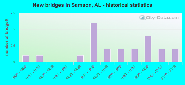
- New bridges - historical statistics
- 11900-1909
- 11910-1919
- 11940-1949
- 61950-1959
- 21960-1969
- 21970-1979
- 21980-1989
- 41990-1999
- 22000-2009
- 22010-2019

- Reconstructed bridges - Historical Statistics
- 41980-1989
- 11990-1999


- Bridge Condition - Deck
- 20.0%Excellent
- 6.7%Very good
- 13.3%Good
- 40.0%Satisfactory
- 13.3%Fair
- 6.7%Serious

- Bridge Condition - Superstructure
- 13.3%Excellent
- 20.0%Very good
- 26.7%Good
- 20.0%Satisfactory
- 6.7%Fair
- 13.3%Serious

- Bridge Condition - Substructure
- 6.7%Excellent
- 13.3%Very good
- 26.7%Good
- 26.7%Satisfactory
- 20.0%Fair
- 6.7%Serious

- Bridge Condition - Channel
- 4.3%Excellent
- 4.3%Very good
- 30.4%Good
- 52.2%Satisfactory
- 8.7%Fair

- Bridge Condition - Culverts
- 12.5%Very good
- 37.5%Good
- 37.5%Satisfactory
- 12.5%Fair
Find on map >> Show street view
Structure Number: 71, Location: 4 MI NE OF SAMSON (Lat: 31.144725, Lng: -85.988081), Route carried "on" structure: County highway , Year Built: 1913, Year Reconstructed: 1992, Status: Posted for load, Structure Length: 2.44m (8.01ft), Average Daily Traffic: 45 (year 2020), Average Future Daily Traffic: 105 (year 2040), Design Load: H 15, Features Intersected: DOUBLE BRIDGES CREEK, Facility Carried by Structure: SPEARS HILL ROAD
Minimum Vertical Clearance: 30+ m (98+ ft), Kilometerpoint: 0.010, Lanes on structure: 1, Owner: County Highway Agency, Approaching Roadway Width: 6.1m (20.0ft), Material/Design: Steel, Design/Construction: Stringer/Multi-beam, Number Of Spans In Main Unit: 1, Number Of Approach Spans: 3, Length of Maximum Span: 9.4m (30.8ft), Curb-To-Curb Width: 4.6m (15.1ft), Out-to-Out Width: 5.0m (16.4ft)
Condition: Deck: Fair, Superstructure: Satisfactory, Substructure: Fair, Channel: Satisfactory, Operating Rating: 26.3 metric tons, Method Used To Determine Operating Rating: Allowable Stress (AS), Inventory Rating: 19.4 metric tons, Method Used To Determine Inventory Rating: Allowable Stress (AS), Structural Evaluation: Somewhat better than minimum adequacy, Deck Geometry: Better than present minimum criteria, Waterway Adequacy: Equal to present minimum criteria, Approach Roadway Alignment: Somewhat better than minimum adequacy, Bridge Posting: Required (Relationship of Operating Rating to Maximum Legal Load: > 39.9% below), Length Of Structure Improvement: 3.31m (10.86ft), Designated Inspection Frequency: Every 24 months, Other Special Inspection Frequency: Every 12 months, Inspection Date: May 2020, Other Special Inspection Date: May 2021, Bridge Improvement Cost: $363,000, Roadway Improvement Cost: $36,000, Total Project Cost: $399,000 ( Estimate for 2022), Deck Structure Type: Wood or Timber, Wearing Surface/Protective System: Wearing Surface: Wood or Timber
Find on map >> Show street view
Structure Number: 2742, Location: 4 MILES EAST SAMSON (Lat: 31.117250, Lng: -85.976656), Route carried "on" structure: County highway , Year Built: 1900, Status: Closed, Structure Length: 3.88m (12.73ft), Average Daily Traffic: 55 (year 2005), Average Future Daily Traffic: 100 (year 2029), Features Intersected: DOUBLE BRIDGES CREEK, Facility Carried by Structure: REVELS FARM ROAD
Minimum Vertical Clearance: 30+ m (98+ ft), Kilometerpoint: 0.010, Lanes on structure: 1, Owner: County Highway Agency, Approaching Roadway Width: 6.1m (20.0ft), Material/Design: Steel, Design/Construction: Truss - Thru, Number Of Spans In Main Unit: 1, Number Of Approach Spans: 5, Length of Maximum Span: 16.8m (55.1ft), Curb-To-Curb Width: 3.7m (12.1ft), Out-to-Out Width: 3.8m (12.5ft)
Condition: Deck: Serious, Superstructure: Serious, Substructure: Serious, Channel: Satisfactory, Deck Geometry: Meets minimum limits, Waterway Adequacy: High priority of corrective action, Approach Roadway Alignment: Meets minimum limits, Bridge Posting: Required (Relationship of Operating Rating to Maximum Legal Load: > 39.9% below), Length Of Structure Improvement: 4.82m (15.81ft), Designated Inspection Frequency: Every 24 months, Critical Feature Inspection Frequency: Every 3 months, Other Special Inspection Frequency: Every 3 months, Inspection Date: January 2009, Critical Feature Inspection Date: March 2009, Other Special Inspection Date: March 2009, Bridge Improvement Cost: $397,000, Roadway Improvement Cost: $40,000, Total Project Cost: $437,000 ( Estimate for 2022), Deck Structure Type: Wood or Timber, Wearing Surface/Protective System: Wearing Surface: Wood or Timber
Find on map >> Show street view
Structure Number: 3454, Location: 4 MI NE OF SAMSON (Lat: 31.129525, Lng: -85.980658), Route carried "on" structure: County highway 40, Year Built: 1949, Status: Open, Structure Length: 6.22m (20.41ft), Average Daily Traffic: 550 (year 2020), Truck Traffic: 5%, Average Future Daily Traffic: 600 (year 2040), Design Load: H 15, Features Intersected: DOUBLE BRIDGES CREEK
Minimum Vertical Clearance: 30+ m (98+ ft), Kilometerpoint: 0.010, Lanes on structure: 2, Owner: County Highway Agency, Approaching Roadway Width: 6.1m (20.0ft), Material/Design: Concrete, Design/Construction: Tee Beam, Number Of Spans In Main Unit: 6, Length of Maximum Span: 10.4m (34.1ft), Curb-To-Curb Width: 6.7m (22.0ft), Out-to-Out Width: 7.6m (24.9ft)
Condition: Deck: Satisfactory, Superstructure: Good, Substructure: Satisfactory, Channel: Good, Operating Rating: 41.6 metric tons, Method Used To Determine Operating Rating: Allowable Stress (AS), Inventory Rating: 24.9 metric tons, Method Used To Determine Inventory Rating: Allowable Stress (AS), Structural Evaluation: Equal to present minimum criteria, Deck Geometry: Meets minimum limits, Waterway Adequacy: Equal to present minimum criteria, Approach Roadway Alignment: Better than present minimum criteria, Length Of Structure Improvement: 7.26m (23.82ft), Designated Inspection Frequency: Every 24 months, Inspection Date: October 2020, Bridge Improvement Cost: $1,195,000, Roadway Improvement Cost: $120,000, Total Project Cost: $1,315,000 ( Estimate for 2022), Deck Structure Type: Concrete Cast-file-Place
Find on map >> Show street view
Structure Number: 397, Location: 1 MILE WEST OF SAMSON (Lat: 31.118033, Lng: -86.064394), Route carried "on" structure: County highway CO017, Year Built: 1951, Status: Open, Structure Length: 0.97m (3.18ft), Average Daily Traffic: 375 (year 2022), Truck Traffic: 5%, Average Future Daily Traffic: 557 (year 2042), Design Load: H 20, Features Intersected: SAMSON BRANCH, Facility Carried by Structure: COUNTY ROAD 17
Minimum Vertical Clearance: 30+ m (98+ ft), Kilometerpoint: 0.010, Lanes on structure: 2, Owner: County Highway Agency, Approaching Roadway Width: 9.1m (29.9ft), Material/Design: Concrete, Design/Construction: Culvert, Number Of Spans In Main Unit: 3, Length of Maximum Span: 3.0m (9.8ft)
Condition: Channel: Fair, Culverts: Satisfactory, Operating Rating: 50.2 metric tons, Method Used To Determine Operating Rating: Load Factor (LF), Inventory Rating: 30.1 metric tons, Method Used To Determine Inventory Rating: Load Factor (LF), Structural Evaluation: Equal to present minimum criteria, Waterway Adequacy: Equal to present minimum criteria, Approach Roadway Alignment: Better than present minimum criteria, Length Of Structure Improvement: 1.63m (5.35ft), Designated Inspection Frequency: Every 24 months, Inspection Date: January 2022, Bridge Improvement Cost: $283,000, Roadway Improvement Cost: $28,000, Total Project Cost: $311,000 ( Estimate for 2022)
Find on map >> Show street view
Structure Number: 3991, Location: .8 MI WEST OF OLD US 231 (Lat: 31.109528, Lng: -86.020489), Route carried "on" structure: County highway 94, Year Built: 1992, Status: Open, Structure Length: 2.07m (6.79ft), Average Daily Traffic: 60 (year 1995), Average Future Daily Traffic: 200 (year 2041), Design Load: HS 20, Features Intersected: BEEMAN CREEK
Minimum Vertical Clearance: 30+ m (98+ ft), Kilometerpoint: 0.010, Lanes on structure: 2, Owner: County Highway Agency, Approaching Roadway Width: 11.0m (36.1ft), Material/Design: Concrete, Design/Construction: Channel Beam, Number Of Spans In Main Unit: 2, Length of Maximum Span: 10.4m (34.1ft), Curb-To-Curb Width: 8.6m (28.2ft), Out-to-Out Width: 9.4m (30.8ft)
Condition: Deck: Very good, Superstructure: Very good, Substructure: Good, Channel: Satisfactory, Operating Rating: 75.6 metric tons, Method Used To Determine Operating Rating: Load Factor (LF), Inventory Rating: 45.4 metric tons, Method Used To Determine Inventory Rating: Load Factor (LF), Structural Evaluation: Better than present minimum criteria, Deck Geometry: Better than present minimum criteria, Waterway Adequacy: Better than present minimum criteria, Approach Roadway Alignment: Better than present minimum criteria, Length Of Structure Improvement: 2.84m (9.32ft), Designated Inspection Frequency: Every 24 months, Inspection Date: January 2021, Bridge Improvement Cost: $584,000, Roadway Improvement Cost: $58,000, Total Project Cost: $642,000 ( Estimate for 2022), Deck Structure Type: Concrete Precast Panels
Find on map >> Show street view
Structure Number: 4409, Location: 7 MI N JCT SR 67 & SR 69 (Lat: 34.373333, Lng: -86.646667), Route carried "on" structure: State highway 67, Year Built: 1952, Status: Open, Structure Length: 0.64m (2.10ft), Average Daily Traffic: 2,940 (year 2019), Truck Traffic: 26%, Average Future Daily Traffic: 3,814 (year 2033), Design Load: H 15, Features Intersected: BRANCH
Minimum Vertical Clearance: 30+ m (98+ ft), Kilometerpoint: 25.766, Lanes on structure: 2, Owner: State Highway Agency, Approaching Roadway Width: 7.6m (24.9ft), Material/Design: Concrete continuous, Design/Construction: Culvert, Number Of Spans In Main Unit: 2, Length of Maximum Span: 3.0m (9.8ft), Curb-To-Curb Width: 7.6m (24.9ft), Out-to-Out Width: 8.5m (27.9ft)
Condition: Channel: Good, Culverts: Good, Operating Rating: 57.9 metric tons, Method Used To Determine Operating Rating: Load Factor (LF), Inventory Rating: 34.7 metric tons, Method Used To Determine Inventory Rating: Load Factor (LF), Structural Evaluation: Better than present minimum criteria, Deck Geometry: High priority of replacement, Waterway Adequacy: Equal to present minimum criteria, Approach Roadway Alignment: Equal to present desirable criteria, Length Of Structure Improvement: 1.26m (4.13ft), Designated Inspection Frequency: Every 24 months, Inspection Date: October 2021, Bridge Improvement Cost: $262,000, Roadway Improvement Cost: $26,000, Total Project Cost: $288,000 ( Estimate for 2022), Wearing Surface/Protective System: Wearing Surface: Bituminous
Find on map >> Show street view
Structure Number: 6119, Location: 3 MI. NE OF SAMSON (Lat: 31.135756, Lng: -86.014561), Route carried "on" structure: County highway , Year Built: 1987, Status: Posted for load, Structure Length: 1.34m (4.40ft), Average Daily Traffic: 111 (year 2020), Average Future Daily Traffic: 165 (year 2040), Design Load: H 15, Features Intersected: ROUNDABOUT CREEK, Facility Carried by Structure: ROUNDABOUT RD.
Minimum Vertical Clearance: 30+ m (98+ ft), Kilometerpoint: 0.010, Lanes on structure: 1, Owner: County Highway Agency, Approaching Roadway Width: 6.1m (20.0ft), Material/Design: Wood or Timber, Design/Construction: Stringer/Multi-beam, Number Of Spans In Main Unit: 3, Length of Maximum Span: 4.3m (14.1ft), Curb-To-Curb Width: 5.6m (18.4ft), Out-to-Out Width: 5.6m (18.4ft)
Condition: Deck: Satisfactory, Superstructure: Serious, Substructure: Fair, Channel: Satisfactory, Operating Rating: 2.7 metric tons, Method Used To Determine Operating Rating: Allowable Stress (AS), Inventory Rating: 1.8 metric tons, Method Used To Determine Inventory Rating: Allowable Stress (AS), Structural Evaluation: High priority of corrective action, Deck Geometry: High priority of corrective action, Waterway Adequacy: Equal to present minimum criteria, Approach Roadway Alignment: Equal to present minimum criteria, Bridge Posting: Required (Relationship of Operating Rating to Maximum Legal Load: > 39.9% below), Length Of Structure Improvement: 2.02m (6.63ft), Designated Inspection Frequency: Every 24 months, Other Special Inspection Frequency: Every 3 months, Inspection Date: June 2020, Other Special Inspection Date: December 2021, Bridge Improvement Cost: $249,000, Roadway Improvement Cost: $25,000, Total Project Cost: $274,000 ( Estimate for 2022), Deck Structure Type: Wood or Timber, Wearing Surface/Protective System: Wearing Surface: Wood or Timber
Find on map >> Show street view
Structure Number: 6509, Location: 2 MI NW OF SAMSON (Lat: 31.130731, Lng: -86.072461), Route carried "on" structure: County highway 17, Year Built: 1959, Year Reconstructed: 1992, Status: Open, Structure Length: 0.87m (2.85ft), Average Daily Traffic: 365 (year 2022), Truck Traffic: 5%, Average Future Daily Traffic: 405 (year 2042), Design Load: HS 20, Features Intersected: BEE BRANCH
Minimum Vertical Clearance: 30+ m (98+ ft), Kilometerpoint: 0.010, Lanes on structure: 2, Owner: County Highway Agency, Approaching Roadway Width: 8.5m (27.9ft), Material/Design: Concrete, Design/Construction: Culvert, Number Of Spans In Main Unit: 2, Length of Maximum Span: 4.3m (14.1ft)
Condition: Channel: Good, Culverts: Good, Operating Rating: 88.9 metric tons, Method Used To Determine Operating Rating: Load Factor (LF), Inventory Rating: 56.8 metric tons, Method Used To Determine Inventory Rating: Load Factor (LF), Structural Evaluation: Better than present minimum criteria, Waterway Adequacy: Better than present minimum criteria, Approach Roadway Alignment: Equal to present minimum criteria, Length Of Structure Improvement: 1.53m (5.02ft), Designated Inspection Frequency: Every 24 months, Inspection Date: January 2022, Bridge Improvement Cost: $442,000, Roadway Improvement Cost: $44,000, Total Project Cost: $486,000 ( Estimate for 2022)
Find on map >> Show street view
Structure Number: 651, Location: 3 MILES N. SAMSON (Lat: 31.149497, Lng: -86.070656), Route carried "on" structure: County highway 17, Year Built: 1959, Status: Open, Structure Length: 0.63m (2.07ft), Average Daily Traffic: 335 (year 2022), Truck Traffic: 5%, Average Future Daily Traffic: 505 (year 2042), Design Load: H 20, Features Intersected: TIGER BRANCH
Minimum Vertical Clearance: 30+ m (98+ ft), Kilometerpoint: 0.010, Lanes on structure: 2, Owner: County Highway Agency, Approaching Roadway Width: 7.3m (24.0ft), Material/Design: Concrete, Design/Construction: Culvert, Number Of Spans In Main Unit: 2, Length of Maximum Span: 3.0m (9.8ft)
Condition: Channel: Satisfactory, Culverts: Fair, Operating Rating: 51.3 metric tons, Method Used To Determine Operating Rating: Load Factor (LF), Inventory Rating: 30.8 metric tons, Method Used To Determine Inventory Rating: Load Factor (LF), Structural Evaluation: Somewhat better than minimum adequacy, Waterway Adequacy: Equal to present minimum criteria, Approach Roadway Alignment: Equal to present minimum criteria, Length Of Structure Improvement: 1.24m (4.07ft), Designated Inspection Frequency: Every 24 months, Inspection Date: January 2022, Bridge Improvement Cost: $230,000, Roadway Improvement Cost: $23,000, Total Project Cost: $253,000 ( Estimate for 2022)
Find on map >> Show street view
Structure Number: 6645, Location: 2 MI EAST PINEY GROVE (Lat: 31.169608, Lng: -86.019936), Route carried "on" structure: County highway 64, Year Built: 1959, Status: Posted for load, Structure Length: 5.18m (16.99ft), Average Daily Traffic: 134 (year 2020), Truck Traffic: 1%, Average Future Daily Traffic: 175 (year 2040), Design Load: H 15, Features Intersected: TIGHT EYE CREEK
Minimum Vertical Clearance: 7.56m (24.80ft), Kilometerpoint: 0.010, Lanes on structure: 2, Owner: County Highway Agency, Approaching Roadway Width: 6.1m (20.0ft), Material/Design: Concrete, Design/Construction: Tee Beam, Number Of Spans In Main Unit: 5, Length of Maximum Span: 10.4m (34.1ft), Curb-To-Curb Width: 6.7m (22.0ft), Out-to-Out Width: 7.1m (23.3ft)
Condition: Deck: Satisfactory, Superstructure: Satisfactory, Substructure: Satisfactory, Channel: Satisfactory, Operating Rating: 35.7 metric tons, Method Used To Determine Operating Rating: Load Factor (LF), Inventory Rating: 21.4 metric tons, Method Used To Determine Inventory Rating: Load Factor (LF), Structural Evaluation: Equal to present minimum criteria, Deck Geometry: Meets minimum limits, Waterway Adequacy: Equal to present minimum criteria, Approach Roadway Alignment: Equal to present minimum criteria, Bridge Posting: Required (Relationship of Operating Rating to Maximum Legal Load: 0.1 - 9.9% below), Length Of Structure Improvement: 6.20m (20.34ft), Designated Inspection Frequency: Every 24 months, Other Special Inspection Frequency: Every 12 months, Inspection Date: October 2020, Other Special Inspection Date: October 2021, Bridge Improvement Cost: $978,000, Roadway Improvement Cost: $98,000, Total Project Cost: $1,076,000 ( Estimate for 2022), Deck Structure Type: Concrete Cast-file-Place
Find on map >> Show street view
Structure Number: 9573, Location: 0.1 MI N TANNER WILLIAMS (Lat: 30.710625, Lng: -88.259308), Route carried "on" structure: County highway , Year Built: 1968, Status: Open, Structure Length: 1.02m (3.35ft), Average Daily Traffic: 2,448 (year 2020), Truck Traffic: 3%, Average Future Daily Traffic: 3,638 (year 2040), Design Load: H 20, Features Intersected: PIERCE CREEK, Facility Carried by Structure: HUBERT PIERCE RD
Minimum Vertical Clearance: 30+ m (98+ ft), Kilometerpoint: 0.100, Lanes on structure: 2, Owner: County Highway Agency, Approaching Roadway Width: 7.3m (24.0ft), Material/Design: Concrete continuous, Design/Construction: Culvert, Number Of Spans In Main Unit: 4, Length of Maximum Span: 2.4m (7.9ft)
Condition: Channel: Fair, Culverts: Satisfactory, Operating Rating: 58.3 metric tons, Method Used To Determine Operating Rating: Load Factor (LF), Inventory Rating: 35.0 metric tons, Method Used To Determine Inventory Rating: Load Factor (LF), Structural Evaluation: Equal to present minimum criteria, Waterway Adequacy: Better than present minimum criteria, Approach Roadway Alignment: Equal to present desirable criteria, Length Of Structure Improvement: 1.69m (5.54ft), Designated Inspection Frequency: Every 24 months, Inspection Date: August 2020, Bridge Improvement Cost: $372,000, Roadway Improvement Cost: $37,000, Total Project Cost: $409,000 ( Estimate for 2022)
Find on map >> Show street view
Structure Number: 994, Location: 4 MILES SE OF SAMSON (Lat: 31.056544, Lng: -86.037508), Route carried "on" structure: County highway , Year Built: 1969, Year Reconstructed: 1993, Status: Posted for load, Structure Length: 2.07m (6.79ft), Average Daily Traffic: 25 (year 2020), Average Future Daily Traffic: 35 (year 2040), Design Load: H 15, Features Intersected: SANDY CREEK, Facility Carried by Structure: ROSEWOOD RD.
Minimum Vertical Clearance: 30+ m (98+ ft), Kilometerpoint: 0.010, Lanes on structure: 1, Owner: County Highway Agency, Approaching Roadway Width: 6.1m (20.0ft), Material/Design: Wood or Timber, Design/Construction: Stringer/Multi-beam, Number Of Spans In Main Unit: 4, Length of Maximum Span: 5.2m (17.1ft), Curb-To-Curb Width: 4.6m (15.1ft), Out-to-Out Width: 5.0m (16.4ft)
Condition: Deck: Satisfactory, Superstructure: Good, Substructure: Satisfactory, Channel: Satisfactory, Operating Rating: 29.6 metric tons, Method Used To Determine Operating Rating: Allowable Stress (AS), Inventory Rating: 21.9 metric tons, Method Used To Determine Inventory Rating: Allowable Stress (AS), Structural Evaluation: Equal to present minimum criteria, Deck Geometry: Better than present minimum criteria, Waterway Adequacy: Equal to present minimum criteria, Approach Roadway Alignment: Somewhat better than minimum adequacy, Bridge Posting: Required (Relationship of Operating Rating to Maximum Legal Load: 20.0 - 29.9% below), Length Of Structure Improvement: 2.84m (9.32ft), Designated Inspection Frequency: Every 24 months, Other Special Inspection Frequency: Every 12 months, Inspection Date: April 2020, Other Special Inspection Date: April 2021, Bridge Improvement Cost: $311,000, Roadway Improvement Cost: $31,000, Total Project Cost: $342,000 ( Estimate for 2022), Deck Structure Type: Wood or Timber, Wearing Surface/Protective System: Wearing Surface: Wood or Timber
Find on map >> Show street view
Structure Number: 12187, Location: .6 MI. E. SR.153 (Lat: 31.112467, Lng: -86.103633), Route carried "on" structure: State highway 52, Year Built: 1979, Status: Open, Structure Length: 6.22m (20.41ft), Average Daily Traffic: 3,430 (year 2013), Truck Traffic: 8%, Average Future Daily Traffic: 4,978 (year 2033), Design Load: HS 20, Features Intersected: PEA RIVER RELIEF
Minimum Vertical Clearance: 30+ m (98+ ft), Kilometerpoint: 24.456, Lanes on structure: 2, Owner: State Highway Agency, Approaching Roadway Width: 13.4m (44.0ft), Material/Design: Prestressed concrete continuous, Design/Construction: Stringer/Multi-beam, Number Of Spans In Main Unit: 6, Length of Maximum Span: 10.4m (34.1ft), Curb-To-Curb Width: 13.4m (44.0ft), Out-to-Out Width: 14.3m (46.9ft)
Condition: Deck: Good, Superstructure: Good, Substructure: Good, Channel: Good, Operating Rating: 46.4 metric tons, Method Used To Determine Operating Rating: Load Factor (LF), Inventory Rating: 27.9 metric tons, Method Used To Determine Inventory Rating: Load Factor (LF), Structural Evaluation: Better than present minimum criteria, Deck Geometry: Better than present minimum criteria, Waterway Adequacy: Equal to present desirable criteria, Approach Roadway Alignment: Equal to present desirable criteria, Length Of Structure Improvement: 7.26m (23.82ft), Designated Inspection Frequency: Every 24 months, Inspection Date: July 2020, Bridge Improvement Cost: $2,339,000, Roadway Improvement Cost: $234,000, Total Project Cost: $2,573,000 ( Estimate for 2022), Deck Structure Type: Concrete Cast-file-Place
Find on map >> Show street view
Structure Number: 12188, Location: .8 MI. E. SR.153 (Lat: 31.112217, Lng: -86.100383), Route carried "on" structure: State highway 52, Year Built: 1979, Status: Open, Structure Length: 25.57m (83.89ft), Average Daily Traffic: 3,430 (year 2013), Truck Traffic: 8%, Average Future Daily Traffic: 4,978 (year 2033), Design Load: HS 20, Features Intersected: PEA RIVER
Minimum Vertical Clearance: 30+ m (98+ ft), Kilometerpoint: 24.779, Lanes on structure: 2, Owner: State Highway Agency, Approaching Roadway Width: 13.4m (44.0ft), Material/Design: Steel continuous, Design/Construction: Stringer/Multi-beam, Number Of Spans In Main Unit: 3, Number Of Approach Spans: 17, Length of Maximum Span: 30.5m (100.1ft), Curb or Sidewalk Widths: Left: 0.2m (0.7ft), Right: 0.2m (0.7ft), Curb-To-Curb Width: 13.4m (44.0ft), Out-to-Out Width: 14.3m (46.9ft)
Condition: Deck: Good, Superstructure: Good, Substructure: Good, Channel: Satisfactory, Operating Rating: 57.0 metric tons, Method Used To Determine Operating Rating: Load Factor (LF), Inventory Rating: 34.2 metric tons, Method Used To Determine Inventory Rating: Load Factor (LF), Structural Evaluation: Better than present minimum criteria, Deck Geometry: Better than present minimum criteria, Waterway Adequacy: Equal to present desirable criteria, Approach Roadway Alignment: Equal to present desirable criteria, Length Of Structure Improvement: 25.57m (83.89ft), Designated Inspection Frequency: Every 24 months, Inspection Date: July 2020, Bridge Improvement Cost: $8,241,000, Roadway Improvement Cost: $824,000, Total Project Cost: $9,065,000 ( Estimate for 2022), Deck Structure Type: Concrete Cast-file-Place
Find on map >> Show street view
Structure Number: 16136, Location: 2 MILES SOUTH OF SAMSON (Lat: 31.083817, Lng: -86.039142), Route carried "on" structure: County highway , Year Built: 1993, Status: Open, Structure Length: 0.94m (3.08ft), Average Daily Traffic: 552 (year 2021), Truck Traffic: 3%, Average Future Daily Traffic: 740 (year 2041), Design Load: HS 20, Features Intersected: SANDY CREEK, Facility Carried by Structure: COUNTY HWY. 16
Minimum Vertical Clearance: 7.56m (24.80ft), Kilometerpoint: 0.010, Lanes on structure: 2, Owner: County Highway Agency, Approaching Roadway Width: 7.3m (24.0ft), Material/Design: Concrete, Design/Construction: Culvert, Number Of Spans In Main Unit: 3, Length of Maximum Span: 3.0m (9.8ft)
Condition: Channel: Satisfactory, Culverts: Satisfactory, Operating Rating: 88.9 metric tons, Method Used To Determine Operating Rating: Load Factor (LF), Inventory Rating: 58.7 metric tons, Method Used To Determine Inventory Rating: Load Factor (LF), Structural Evaluation: Equal to present minimum criteria, Waterway Adequacy: Equal to present minimum criteria, Approach Roadway Alignment: Equal to present desirable criteria, Length Of Structure Improvement: 1.62m (5.31ft), Designated Inspection Frequency: Every 24 months, Inspection Date: October 2021, Bridge Improvement Cost: $449,000, Roadway Improvement Cost: $45,000, Total Project Cost: $494,000 ( Estimate for 2022)
Find on map >> Show street view
Structure Number: 16262, Location: 4.0 MI S OF SAMSON (Lat: 31.065578, Lng: -86.095211), Route carried "on" structure: County highway 17, Year Built: 1995, Status: Open, Structure Length: 16.73m (54.89ft), Average Daily Traffic: 640 (year 2021), Truck Traffic: 5%, Average Future Daily Traffic: 765 (year 2041), Design Load: HS 20, Features Intersected: PEA RIVER RELIEF
Minimum Vertical Clearance: 30+ m (98+ ft), Kilometerpoint: 0.010, Lanes on structure: 2, Owner: County Highway Agency, Approaching Roadway Width: 8.5m (27.9ft), Material/Design: Concrete, Design/Construction: Channel Beam, Number Of Spans In Main Unit: 16, Length of Maximum Span: 10.4m (34.1ft), Curb-To-Curb Width: 8.5m (27.9ft), Out-to-Out Width: 9.3m (30.5ft)
Condition: Deck: Satisfactory, Superstructure: Satisfactory, Substructure: Fair, Channel: Good, Operating Rating: 70.7 metric tons, Method Used To Determine Operating Rating: Load Factor (LF), Inventory Rating: 42.5 metric tons, Method Used To Determine Inventory Rating: Load Factor (LF), Structural Evaluation: Somewhat better than minimum adequacy, Deck Geometry: Somewhat better than minimum adequacy, Waterway Adequacy: Equal to present minimum criteria, Approach Roadway Alignment: Equal to present desirable criteria, Length Of Structure Improvement: 17.46m (57.28ft), Designated Inspection Frequency: Every 24 months, Inspection Date: Febuary 2021, Bridge Improvement Cost: $3,592,000, Roadway Improvement Cost: $359,000, Total Project Cost: $3,951,000 ( Estimate for 2022), Deck Structure Type: Concrete Precast Panels
Find on map >> Show street view
Structure Number: 17349, Location: 3 MILES SE. OF SAMSON (Lat: 31.080444, Lng: -86.018186), Route carried "on" structure: County highway , Year Built: 1957, Year Reconstructed: 1996, Status: Posted for load, Structure Length: 0.91m (2.99ft), Average Daily Traffic: 40 (year 2020), Average Future Daily Traffic: 60 (year 2040), Design Load: H 10, Features Intersected: PUMPKIN CREEK, Facility Carried by Structure: HORNSBY RD.
Minimum Vertical Clearance: 30+ m (98+ ft), Kilometerpoint: 0.000, Lanes on structure: 2, Owner: County Highway Agency, Approaching Roadway Width: 6.1m (20.0ft), Material/Design: Concrete, Design/Construction: Channel Beam, Number Of Spans In Main Unit: 2, Length of Maximum Span: 4.6m (15.1ft), Curb-To-Curb Width: 7.1m (23.3ft), Out-to-Out Width: 7.6m (24.9ft)
Condition: Deck: Fair, Superstructure: Fair, Substructure: Satisfactory, Channel: Satisfactory, Operating Rating: 27.9 metric tons, Method Used To Determine Operating Rating: Load Factor (LF), Inventory Rating: 16.7 metric tons, Method Used To Determine Inventory Rating: Load Factor (LF), Structural Evaluation: Somewhat better than minimum adequacy, Deck Geometry: Somewhat better than minimum adequacy, Waterway Adequacy: Meets minimum limits, Approach Roadway Alignment: Equal to present minimum criteria, Bridge Posting: Required (Relationship of Operating Rating to Maximum Legal Load: 30.0 - 39.9% below), Length Of Structure Improvement: 1.59m (5.22ft), Designated Inspection Frequency: Every 24 months, Other Special Inspection Frequency: Every 12 months, Inspection Date: May 2020, Other Special Inspection Date: May 2021, Bridge Improvement Cost: $261,000, Roadway Improvement Cost: $26,000, Total Project Cost: $287,000 ( Estimate for 2022), Deck Structure Type: Concrete Precast Panels
Find on map >> Show street view
Structure Number: 17423, Location: 2 MILES S.W. OF SAMSON (Lat: 31.080686, Lng: -86.081892), Route carried "on" structure: County highway 17, Year Built: 1999, Status: Open, Structure Length: 0.93m (3.05ft), Average Daily Traffic: 1,119 (year 2021), Truck Traffic: 5%, Average Future Daily Traffic: 1,670 (year 2041), Design Load: HS 20, Features Intersected: PEA RIVER BRANCH
Minimum Vertical Clearance: 7.56m (24.80ft), Kilometerpoint: 0.000, Lanes on structure: 2, Owner: County Highway Agency, Approaching Roadway Width: 6.6m (21.7ft), Material/Design: Concrete, Design/Construction: Culvert, Number Of Spans In Main Unit: 3, Length of Maximum Span: 3.0m (9.8ft)
Condition: Channel: Very good, Culverts: Very good, Operating Rating: 88.9 metric tons, Method Used To Determine Operating Rating: Load Factor (LF), Inventory Rating: 77.7 metric tons, Method Used To Determine Inventory Rating: Load Factor (LF), Structural Evaluation: Equal to present desirable criteria, Waterway Adequacy: Equal to present desirable criteria, Approach Roadway Alignment: Better than present minimum criteria, Length Of Structure Improvement: 1.60m (5.25ft), Designated Inspection Frequency: Every 24 months, Inspection Date: Febuary 2021, Bridge Improvement Cost: $480,000, Roadway Improvement Cost: $48,000, Total Project Cost: $528,000 ( Estimate for 2022)
Find on map >> Show street view
Structure Number: 17484, Location: 3 MILES N.E. OF SAMSON (Lat: 31.151592, Lng: -86.010303), Route carried "on" structure: County highway 43, Year Built: 2001, Status: Open, Structure Length: 6.22m (20.41ft), Average Daily Traffic: 920 (year 2022), Average Future Daily Traffic: 1,375 (year 2042), Design Load: HS 20, Features Intersected: TIGHT EYE CREEK
Minimum Vertical Clearance: 30+ m (98+ ft), Kilometerpoint: 0.000, Lanes on structure: 2, Owner: County Highway Agency, Approaching Roadway Width: 6.1m (20.0ft), Material/Design: Concrete, Design/Construction: Channel Beam, Number Of Spans In Main Unit: 7, Length of Maximum Span: 10.4m (34.1ft), Curb-To-Curb Width: 8.5m (27.9ft), Out-to-Out Width: 9.3m (30.5ft)
Condition: Deck: Satisfactory, Superstructure: Very good, Substructure: Very good, Channel: Good, Operating Rating: 73.7 metric tons, Method Used To Determine Operating Rating: Load Factor (LF), Inventory Rating: 44.2 metric tons, Method Used To Determine Inventory Rating: Load Factor (LF), Structural Evaluation: Equal to present desirable criteria, Deck Geometry: Somewhat better than minimum adequacy, Waterway Adequacy: Superior to present desirable criteria, Approach Roadway Alignment: Superior to present desirable criteria, Length Of Structure Improvement: 7.26m (23.82ft), Designated Inspection Frequency: Every 24 months, Inspection Date: January 2022, Bridge Improvement Cost: $1,493,000, Roadway Improvement Cost: $149,000, Total Project Cost: $1,642,000 ( Estimate for 2022), Deck Structure Type: Concrete Precast Panels
Find on map >> Show street view
Structure Number: 19385, Location: 4 Miles NE os Samson (Lat: 31.145972, Lng: -85.995203), Route carried "on" structure: County highway , Year Built: 2017, Status: Open, Structure Length: 4.88m (16.01ft), Average Daily Traffic: 7 (year 2020), Average Future Daily Traffic: 10 (year 2040), Design Load: HS 20, Features Intersected: TIGHT EYE CREEK, Facility Carried by Structure: COUNTY RD 79
Minimum Vertical Clearance: 30+ m (98+ ft), Kilometerpoint: 0.000, Lanes on structure: 2, Owner: County Highway Agency, Approaching Roadway Width: 7.9m (25.9ft), Material/Design: Prestressed concrete, Design/Construction: Stringer/Multi-beam, Number Of Spans In Main Unit: 3, Length of Maximum Span: 24.4m (80.1ft), Curb-To-Curb Width: 7.9m (25.9ft), Out-to-Out Width: 9.4m (30.8ft)
Condition: Deck: Excellent, Superstructure: Excellent, Substructure: Excellent, Channel: Excellent, Operating Rating: 55.1 metric tons, Method Used To Determine Operating Rating: Load Factor (LF), Inventory Rating: 33.0 metric tons, Method Used To Determine Inventory Rating: Load Factor (LF), Structural Evaluation: Superior to present desirable criteria, Deck Geometry: Equal to present minimum criteria, Waterway Adequacy: Superior to present desirable criteria, Approach Roadway Alignment: Better than present minimum criteria, Length Of Structure Improvement: 5.89m (19.32ft), Designated Inspection Frequency: Every 24 months, Inspection Date: June 2020, Bridge Improvement Cost: $1,211,000, Roadway Improvement Cost: $121,000, Total Project Cost: $1,332,000 ( Estimate for 2022), Deck Structure Type: Concrete Cast-file-Place
Find on map >> Show street view
Structure Number: 19796, Location: 1.0 MILES SOUTH OF SAMSON (Lat: 31.097078, Lng: -86.036117), Route carried "on" structure: County highway , Year Built: 2006, Status: Open, Structure Length: 0.73m (2.40ft), Average Daily Traffic: 52 (year 2021), Average Future Daily Traffic: 73 (year 2041), Design Load: HS 20, Features Intersected: SANDY CREEK, Facility Carried by Structure: ARMSTRONG ROAD
Minimum Vertical Clearance: 30+ m (98+ ft), Kilometerpoint: 0.000, Lanes on structure: 2, Owner: County Highway Agency, Approaching Roadway Width: 7.0m (23.0ft), Material/Design: Concrete, Design/Construction: Channel Beam, Number Of Spans In Main Unit: 1, Length of Maximum Span: 7.3m (24.0ft), Curb-To-Curb Width: 7.6m (24.9ft), Out-to-Out Width: 8.3m (27.2ft)
Condition: Deck: Excellent, Superstructure: Very good, Substructure: Good, Channel: Satisfactory, Operating Rating: 59.6 metric tons, Method Used To Determine Operating Rating: Load Factor (LF), Inventory Rating: 35.7 metric tons, Method Used To Determine Inventory Rating: Load Factor (LF), Structural Evaluation: Better than present minimum criteria, Deck Geometry: Equal to present minimum criteria, Waterway Adequacy: Better than present minimum criteria, Approach Roadway Alignment: Better than present minimum criteria, Length Of Structure Improvement: 1.38m (4.53ft), Designated Inspection Frequency: Every 24 months, Inspection Date: October 2021, Bridge Improvement Cost: $255,000, Roadway Improvement Cost: $26,000, Total Project Cost: $281,000 ( Estimate for 2022), Deck Structure Type: Concrete Precast Panels
Find on map >> Show street view
Structure Number: 20308, Location: 3 MILES SE OF SAMSON (Lat: 31.081769, Lng: -86.011747), Route carried "on" structure: County highway , Year Built: 2013, Status: Open, Structure Length: 1.04m (3.41ft), Average Daily Traffic: 40 (year 2021), Average Future Daily Traffic: 58 (year 2041), Design Load: HS 20, Features Intersected: PUMPKIN CREEK, Facility Carried by Structure: HORNSBY ROAD
Minimum Vertical Clearance: 30+ m (98+ ft), Kilometerpoint: 0.010, Lanes on structure: 2, Owner: County Highway Agency, Approaching Roadway Width: 6.7m (22.0ft), Material/Design: Concrete, Design/Construction: Channel Beam, Number Of Spans In Main Unit: 1, Length of Maximum Span: 10.4m (34.1ft), Curb-To-Curb Width: 7.5m (24.6ft), Out-to-Out Width: 8.2m (26.9ft)
Condition: Deck: Excellent, Superstructure: Excellent, Substructure: Very good, Channel: Satisfactory, Operating Rating: 75.2 metric tons, Method Used To Determine Operating Rating: Load Factor (LF), Inventory Rating: 45.2 metric tons, Method Used To Determine Inventory Rating: Load Factor (LF), Structural Evaluation: Equal to present desirable criteria, Deck Geometry: Equal to present minimum criteria, Waterway Adequacy: Better than present minimum criteria, Approach Roadway Alignment: Better than present minimum criteria, Length Of Structure Improvement: 1.71m (5.61ft), Designated Inspection Frequency: Every 24 months, Inspection Date: June 2021, Bridge Improvement Cost: $304,000, Roadway Improvement Cost: $30,000, Total Project Cost: $334,000 ( Estimate for 2022), Deck Structure Type: Concrete Precast Panels
Find on map >> Show street view
Structure Number: 20824, Location: .2 MILE FROM SR 52 (Lat: 31.110617, Lng: -86.111133), Route carried "on" structure: State highway 153, Year Built: 1985, Year Reconstructed: 1992, Status: Open, Structure Length: 0.79m (2.59ft), Average Daily Traffic: 1,730 (year 2013), Truck Traffic: 12%, Average Future Daily Traffic: 2,353 (year 2033), Design Load: HS 20, Features Intersected: STREAM
Minimum Vertical Clearance: 30.18m (99.02ft), Kilometerpoint: 14.178, Lanes on structure: 2, Owner: State Highway Agency, Approaching Roadway Width: 11.0m (36.1ft), Material/Design: Concrete, Design/Construction: Culvert, Number Of Spans In Main Unit: 4, Length of Maximum Span: 1.5m (4.9ft)
Condition: Channel: Good, Culverts: Good, Operating Rating: 43.5 metric tons, Method Used To Determine Operating Rating: Field evaluation and documented engineering judgment, Inventory Rating: 32.7 metric tons, Method Used To Determine Inventory Rating: Field evaluation and documented engineering judgment, Structural Evaluation: Better than present minimum criteria, Waterway Adequacy: Equal to present desirable criteria, Approach Roadway Alignment: Equal to present desirable criteria, Length Of Structure Improvement: 1.45m (4.76ft), Designated Inspection Frequency: Every 24 months, Inspection Date: October 2021, Bridge Improvement Cost: $418,000, Roadway Improvement Cost: $42,000, Total Project Cost: $460,000 ( Estimate for 2022)