Bridge Statistics for San Carlos, Arizona (AZ)
Condition, Traffic, Stress, Structural Evaluation, Project Costs
- National Bridge Inventory (NBI) Statistics
- 13Number of bridges
- 223ft / 67.7mTotal length
- $1,000Total costs
- 25,528Total average daily traffic
- 1,745Total average daily truck traffic
- 27,319Total future (year 2036) average daily traffic
- National Bridge Inventory (NBI) Registered Bridges for San Carlos
- No street view available for this location
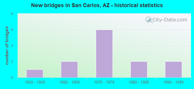
- New bridges - historical statistics
- 11950-1959
- 21960-1969
- 61970-1979
- 21980-1989
- 21990-1999

- Reconstructed bridges - Historical Statistics
- 12000-2009
- 12010-2019


- Bridge Condition - Deck
- 33.3%Good
- 66.7%Satisfactory

- Bridge Condition - Superstructure
- 33.3%Good
- 66.7%Satisfactory

- Bridge Condition - Substructure
- 33.3%Good
- 66.7%Satisfactory

- Bridge Condition - Channel
- 7.7%Very good
- 30.8%Good
- 46.2%Satisfactory
- 15.4%Fair

- Bridge Condition - Culverts
- 60.0%Good
- 40.0%Satisfactory
Find on map >> Show street view
Structure Number: H207, Location: 3.7 KM S OF SAN CARLOS (Lat: 33.322750, Lng: -110.446611), Route carried "on" structure: Federal lands road 103, Year Built: 1989, Status: Open, Structure Length: 24.69m (81.00ft), Average Daily Traffic: 3,000 (year 2021), Truck Traffic: 5%, Average Future Daily Traffic: 3,500 (year 2039), Design Load: HS 20+Mod, Features Intersected: SAN CARLOS RIVER
Minimum Vertical Clearance: 30+ m (98+ ft), Kilometerpoint: 0.400, Lanes on structure: 2, Owner: Bureau of Indian Affairs, Approaching Roadway Width: 8.5m (27.9ft), Material/Design: Prestressed concrete, Design/Construction: Stringer/Multi-beam, Number Of Spans In Main Unit: 7, Length of Maximum Span: 35.5m (116.5ft), Curb or Sidewalk Widths: Left: 2.0m (6.6ft), Right: 0.4m (1.3ft), Curb-To-Curb Width: 10.2m (33.5ft), Out-to-Out Width: 11.3m (37.1ft)
Condition: Deck: Good, Superstructure: Good, Substructure: Good, Channel: Satisfactory, Operating Rating: 51.5 metric tons, Method Used To Determine Operating Rating: Allowable Stress (AS), Inventory Rating: 39.7 metric tons, Method Used To Determine Inventory Rating: Allowable Stress (AS), Structural Evaluation: Better than present minimum criteria, Deck Geometry: Meets minimum limits, Waterway Adequacy: Equal to present minimum criteria, Approach Roadway Alignment: Equal to present desirable criteria, Designated Inspection Frequency: Every 24 months, Inspection Date: December 2021, Deck Structure Type: Concrete Cast-file-Place, Wearing Surface/Protective System: Wearing Surface: Monolithic Concrete
Find on map >> Show street view
Structure Number: H208, Location: 2.7 KM N OF SAN CARLOS (Lat: 33.376472, Lng: -110.449167), Route carried "on" structure: Federal lands road 10, Year Built: 1994, Status: Open, Structure Length: 14.63m (48.00ft), Average Daily Traffic: 160 (year 2021), Truck Traffic: 3%, Average Future Daily Traffic: 190 (year 2039), Design Load: HS 20, Features Intersected: SEVEN MILE WASH
Minimum Vertical Clearance: 30+ m (98+ ft), Kilometerpoint: 0.120, Lanes on structure: 2, Owner: Bureau of Indian Affairs, Approaching Roadway Width: 14.6m (47.9ft), Skew: 2 degrees, Material/Design: Prestressed concrete, Design/Construction: Slab, Number Of Spans In Main Unit: 10, Length of Maximum Span: 15.4m (50.5ft), Curb or Sidewalk Widths: Left: 0.4m (1.3ft), Right: 2.1m (6.9ft), Curb-To-Curb Width: 10.4m (34.1ft), Out-to-Out Width: 13.1m (43.0ft)
Condition: Deck: Satisfactory, Superstructure: Satisfactory, Substructure: Satisfactory, Channel: Good, Operating Rating: 44.2 metric tons, Method Used To Determine Operating Rating: Allowable Stress (AS), Inventory Rating: 32.4 metric tons, Method Used To Determine Inventory Rating: Allowable Stress (AS), Structural Evaluation: Equal to present minimum criteria, Deck Geometry: Better than present minimum criteria, Waterway Adequacy: Better than present minimum criteria, Approach Roadway Alignment: Equal to present desirable criteria, Designated Inspection Frequency: Every 24 months, Inspection Date: December 2021, Deck Structure Type: Concrete Cast-file-Place, Wearing Surface/Protective System: Wearing Surface: Bituminous, Deck Protection: Epoxy Coated Reinforcing
Find on map >> Show street view
Structure Number: H58616B082, Location: 1.9 KM SOUTH OF HWY 70 (Lat: 33.283056, Lng: -110.458583), Route carried "on" structure: Federal lands road 3, Year Built: 1960, Status: Open, Structure Length: 1.39m (4.56ft), Average Daily Traffic: 1,000 (year 2021), Truck Traffic: 5%, Average Future Daily Traffic: 1,105 (year 2038), Design Load: HS 25 or greater, Features Intersected: WASH
Minimum Vertical Clearance: 30+ m (98+ ft), Kilometerpoint: 1.900, Lanes on structure: 2, Owner: Bureau of Indian Affairs, Approaching Roadway Width: 7.3m (24.0ft), Skew: 1 degrees, Material/Design: Steel, Design/Construction: Culvert, Number Of Spans In Main Unit: 4, Length of Maximum Span: 2.8m (9.2ft), Curb-To-Curb Width: 8.4m (27.6ft), Out-to-Out Width: 26.0m (85.3ft)
Condition: Channel: Satisfactory, Culverts: Good, Operating Rating: 55.3 metric tons, Method Used To Determine Operating Rating: Load Factor (LF), Inventory Rating: 40.8 metric tons, Method Used To Determine Inventory Rating: Load Factor (LF), Structural Evaluation: Better than present minimum criteria, Deck Geometry: Somewhat better than minimum adequacy, Waterway Adequacy: Better than present minimum criteria, Approach Roadway Alignment: Equal to present desirable criteria, Designated Inspection Frequency: Every 24 months, Inspection Date: December 2021
Find on map >> Show street view
Structure Number: H58616B0824, Location: 3.5 KM EAST OF CUTTER (Lat: 33.363750, Lng: -110.613889), Route carried "on" structure: Federal lands road 6, Year Built: 1970, Status: Open, Structure Length: 1.29m (4.23ft), Average Daily Traffic: 2,000 (year 2021), Truck Traffic: 5%, Average Future Daily Traffic: 2,500 (year 2038), Design Load: HS 20, Features Intersected: WASH
Minimum Vertical Clearance: 30+ m (98+ ft), Kilometerpoint: 4.000, Lanes on structure: 2, Owner: Bureau of Indian Affairs, Approaching Roadway Width: 7.8m (25.6ft), Material/Design: Concrete, Design/Construction: Culvert, Number Of Spans In Main Unit: 4, Length of Maximum Span: 3.1m (10.2ft), Curb-To-Curb Width: 7.8m (25.6ft), Out-to-Out Width: 12.4m (40.7ft)
Condition: Channel: Satisfactory, Culverts: Satisfactory, Operating Rating: 44.4 metric tons, Method Used To Determine Operating Rating: Load Factor (LF), Inventory Rating: 32.7 metric tons, Method Used To Determine Inventory Rating: Load Factor (LF), Structural Evaluation: Equal to present minimum criteria, Deck Geometry: Meets minimum limits, Waterway Adequacy: Equal to present desirable criteria, Approach Roadway Alignment: Equal to present desirable criteria, Designated Inspection Frequency: Every 24 months, Inspection Date: December 2021
Find on map >> Show street view
Structure Number: H58616B0825, Location: CUTTER RD AND APACHE AVE (Lat: 33.350339, Lng: -110.454778), Route carried "on" structure: Federal lands road 6, Year Built: 1990, Year Reconstructed: 2017, Status: Open, Structure Length: 1.25m (4.10ft), Average Daily Traffic: 2,000 (year 2021), Truck Traffic: 5%, Average Future Daily Traffic: 2,500 (year 2038), Design Load: HS 25 or greater, Features Intersected: LITTLE GILSON WASH
Minimum Vertical Clearance: 30+ m (98+ ft), Kilometerpoint: 19.500, Lanes on structure: 2, Owner: Bureau of Indian Affairs, Approaching Roadway Width: 11.9m (39.0ft), Material/Design: Aluminum, Iron, Design/Construction: Culvert, Number Of Spans In Main Unit: 2, Length of Maximum Span: 5.9m (19.4ft), Curb or Sidewalk Widths: Left: 2.0m (6.6ft), Right: 2.0m (6.6ft), Curb-To-Curb Width: 11.9m (39.0ft), Out-to-Out Width: 25.0m (82.0ft)
Condition: Channel: Satisfactory, Culverts: Good, Operating Rating: 55.3 metric tons, Method Used To Determine Operating Rating: Load Factor (LF), Inventory Rating: 40.8 metric tons, Method Used To Determine Inventory Rating: Load Factor (LF), Structural Evaluation: Better than present minimum criteria, Deck Geometry: Equal to present minimum criteria, Waterway Adequacy: Equal to present minimum criteria, Approach Roadway Alignment: Equal to present desirable criteria, Designated Inspection Frequency: Every 24 months, Inspection Date: December 2021
Find on map >> Show street view
Structure Number: H58616B0831, Location: 32 KM EAST OF SAN CARLOS (Lat: 33.358889, Lng: -110.081083), Route carried "on" structure: Federal lands road 8, Year Built: 1970, Status: Open, Structure Length: 1.12m (3.67ft), Average Daily Traffic: 170 (year 2016), Truck Traffic: 5%, Average Future Daily Traffic: 205 (year 2036), Design Load: HS 20, Features Intersected: WASH
Minimum Vertical Clearance: 30+ m (98+ ft), Kilometerpoint: 35.300, Lanes on structure: 2, Owner: Bureau of Indian Affairs, Approaching Roadway Width: 8.0m (26.2ft), Skew: 3 degrees, Material/Design: Concrete continuous, Design/Construction: Culvert, Number Of Spans In Main Unit: 3, Length of Maximum Span: 3.5m (11.5ft), Curb-To-Curb Width: 8.0m (26.2ft), Out-to-Out Width: 8.5m (27.9ft)
Condition: Channel: Very good, Culverts: Good, Operating Rating: 54.1 metric tons, Method Used To Determine Operating Rating: Load Factor (LF), Inventory Rating: 32.4 metric tons, Method Used To Determine Inventory Rating: Load Factor (LF), Structural Evaluation: Better than present minimum criteria, Deck Geometry: Somewhat better than minimum adequacy, Waterway Adequacy: Equal to present desirable criteria, Approach Roadway Alignment: Equal to present desirable criteria, Designated Inspection Frequency: Every 24 months, Inspection Date: October 2016
Find on map >> Show street view
Structure Number: H58616B0832, Location: 37 KM EAST OF SAN CARLOS (Lat: 33.348222, Lng: -110.056528), Route carried "on" structure: Federal lands road 8, Year Built: 1970, Status: Open, Structure Length: 0.75m (2.46ft), Average Daily Traffic: 170 (year 2021), Truck Traffic: 5%, Average Future Daily Traffic: 200 (year 2038), Design Load: HS 20, Features Intersected: WASH
Minimum Vertical Clearance: 30+ m (98+ ft), Kilometerpoint: 37.800, Lanes on structure: 2, Owner: Bureau of Indian Affairs, Approaching Roadway Width: 7.8m (25.6ft), Skew: 3 degrees, Material/Design: Concrete, Design/Construction: Culvert, Number Of Spans In Main Unit: 2, Length of Maximum Span: 3.6m (11.8ft), Curb-To-Curb Width: 7.8m (25.6ft), Out-to-Out Width: 20.7m (67.9ft)
Condition: Channel: Fair, Culverts: Satisfactory, Operating Rating: 54.5 metric tons, Method Used To Determine Operating Rating: Load Factor (LF), Inventory Rating: 32.6 metric tons, Method Used To Determine Inventory Rating: Load Factor (LF), Structural Evaluation: Equal to present minimum criteria, Deck Geometry: Somewhat better than minimum adequacy, Waterway Adequacy: Equal to present desirable criteria, Approach Roadway Alignment: Equal to present desirable criteria, Designated Inspection Frequency: Every 24 months, Inspection Date: December 2021
Find on map >> Show street view
Structure Number: H58616B0833, Location: 38 KM EAST OF SAN CARLOS (Lat: 33.345056, Lng: -110.043694), Route carried "on" structure: Federal lands road 8, Year Built: 1970, Status: Open, Structure Length: 0.64m (2.10ft), Average Daily Traffic: 170 (year 2021), Truck Traffic: 5%, Average Future Daily Traffic: 203 (year 2038), Design Load: HS 20, Features Intersected: WASH
Minimum Vertical Clearance: 30+ m (98+ ft), Kilometerpoint: 39.000, Lanes on structure: 2, Owner: Bureau of Indian Affairs, Approaching Roadway Width: 8.2m (26.9ft), Material/Design: Concrete, Design/Construction: Culvert, Number Of Spans In Main Unit: 2, Length of Maximum Span: 3.1m (10.2ft), Curb-To-Curb Width: 8.2m (26.9ft), Out-to-Out Width: 14.9m (48.9ft)
Condition: Channel: Satisfactory, Culverts: Good, Operating Rating: 54.5 metric tons, Method Used To Determine Operating Rating: Load Factor (LF), Inventory Rating: 32.7 metric tons, Method Used To Determine Inventory Rating: Load Factor (LF), Structural Evaluation: Better than present minimum criteria, Deck Geometry: Somewhat better than minimum adequacy, Waterway Adequacy: Equal to present desirable criteria, Approach Roadway Alignment: Equal to present desirable criteria, Designated Inspection Frequency: Every 24 months, Inspection Date: December 2021
Find on map >> Show street view
Structure Number: H58616B0834, Location: 48 KM EAST OF SAN CARLOS (Lat: 33.305806, Lng: -109.937694), Route carried "on" structure: Federal lands road 8, Year Built: 1970, Status: Open, Structure Length: 1.36m (4.46ft), Average Daily Traffic: 170 (year 2021), Truck Traffic: 5%, Average Future Daily Traffic: 203 (year 2038), Design Load: HS 20, Features Intersected: WASH
Minimum Vertical Clearance: 30+ m (98+ ft), Kilometerpoint: 49.900, Lanes on structure: 2, Owner: Bureau of Indian Affairs, Approaching Roadway Width: 7.7m (25.3ft), Skew: 4 degrees, Material/Design: Concrete, Design/Construction: Culvert, Number Of Spans In Main Unit: 3, Length of Maximum Span: 4.2m (13.8ft), Curb-To-Curb Width: 7.7m (25.3ft), Out-to-Out Width: 13.9m (45.6ft)
Condition: Channel: Fair, Culverts: Satisfactory, Operating Rating: 44.5 metric tons, Method Used To Determine Operating Rating: Load Factor (LF), Inventory Rating: 32.7 metric tons, Method Used To Determine Inventory Rating: Load Factor (LF), Structural Evaluation: Equal to present minimum criteria, Deck Geometry: Somewhat better than minimum adequacy, Waterway Adequacy: Equal to present desirable criteria, Approach Roadway Alignment: Equal to present desirable criteria, Designated Inspection Frequency: Every 24 months, Inspection Date: December 2021
Find on map >> Show street view
Structure Number: H58616B0835, Location: 5 KM SE OF POINT OF PINES (Lat: 33.337056, Lng: -109.720778), Route carried "on" structure: Federal lands road 4, Year Built: 1980, Status: Open, Structure Length: 0.78m (2.56ft), Average Daily Traffic: 45 (year 2021), Truck Traffic: 5%, Average Future Daily Traffic: 50 (year 2038), Design Load: HS 25 or greater, Features Intersected: WASH
Minimum Vertical Clearance: 30+ m (98+ ft), Kilometerpoint: 76.300, Lanes on structure: 2, Owner: Bureau of Indian Affairs, Approaching Roadway Width: 8.2m (26.9ft), Skew: 3 degrees, Material/Design: Steel, Design/Construction: Culvert, Number Of Spans In Main Unit: 4, Length of Maximum Span: 1.5m (4.9ft), Curb-To-Curb Width: 8.2m (26.9ft), Out-to-Out Width: 24.2m (79.4ft)
Condition: Channel: Good, Culverts: Satisfactory, Operating Rating: 55.3 metric tons, Method Used To Determine Operating Rating: Load Factor (LF), Inventory Rating: 40.8 metric tons, Method Used To Determine Inventory Rating: Load Factor (LF), Structural Evaluation: Equal to present minimum criteria, Deck Geometry: Equal to present minimum criteria, Waterway Adequacy: Equal to present desirable criteria, Approach Roadway Alignment: Equal to present desirable criteria, Designated Inspection Frequency: Every 24 months, Inspection Date: December 2021
Find on map >> Show street view
Structure Number: H58616B1319, Location: ROUTE 170 IN SAN CARLOS (Lat: 33.348361, Lng: -110.452250), Route carried "on" structure: Federal lands road 170, Year Built: 1970, Status: Open, Structure Length: 18.01m (59.09ft), Average Daily Traffic: 7,500 (year 2021), Truck Traffic: 2%, Average Future Daily Traffic: 7,500 (year 2039), Features Intersected: GILSON WASH
Minimum Vertical Clearance: 30+ m (98+ ft), Kilometerpoint: 44.200, Lanes on structure: 2, Owner: Bureau of Indian Affairs, Approaching Roadway Width: 9.7m (31.8ft), Material/Design: Concrete continuous, Design/Construction: Slab, Number Of Spans In Main Unit: 20, Length of Maximum Span: 9.2m (30.2ft), Curb or Sidewalk Widths: Left: 2.0m (6.6ft), Right: 0.3m (1.0ft), Curb-To-Curb Width: 9.1m (29.9ft), Out-to-Out Width: 11.6m (38.1ft)
Condition: Deck: Satisfactory, Superstructure: Satisfactory, Substructure: Satisfactory, Channel: Satisfactory, Operating Rating: 44.2 metric tons, Method Used To Determine Operating Rating: Load Factor (LF), Inventory Rating: 32.4 metric tons, Method Used To Determine Inventory Rating: Load Factor (LF), Structural Evaluation: Equal to present minimum criteria, Deck Geometry: Meets minimum limits, Waterway Adequacy: Equal to present desirable criteria, Approach Roadway Alignment: Equal to present desirable criteria, Designated Inspection Frequency: Every 24 months, Inspection Date: December 2021, Deck Structure Type: Concrete Cast-file-Place, Wearing Surface/Protective System: Wearing Surface: Monolithic Concrete
Find on map >> Show street view
Structure Number: 4281, Location: 4.1 mi W Jct SR 170 (Lat: 33.317472, Lng: -110.527028), Route carried "on" structure: US 70, Year Built: 1953, Status: Open, Structure Length: 1.13m (3.71ft), Average Daily Traffic: 4,867 (year 2018), Truck Traffic: 15%, Average Future Daily Traffic: 4,877 (year 2038), Design Load: HS 20, Features Intersected: Wash
Minimum Vertical Clearance: 30+ m (98+ ft), Kilometerpoint: 429.711, Lanes on structure: 2, Owner: State Highway Agency, Approaching Roadway Width: 10.4m (34.1ft), Skew: 3 degrees, Material/Design: Concrete continuous, Design/Construction: Culvert, Number Of Spans In Main Unit: 3, Length of Maximum Span: 3.0m (9.8ft), Curb-To-Curb Width: 10.4m (34.1ft), Out-to-Out Width: 11.2m (36.7ft)
Condition: Channel: Good, Culverts: Good, Operating Rating: 53.5 metric tons, Method Used To Determine Operating Rating: Load Factor (LF), Inventory Rating: 31.8 metric tons, Method Used To Determine Inventory Rating: Load Factor (LF), Structural Evaluation: Better than present minimum criteria, Deck Geometry: Somewhat better than minimum adequacy, Waterway Adequacy: Better than present minimum criteria, Approach Roadway Alignment: Equal to present desirable criteria, Length Of Structure Improvement: 1.89m (6.20ft), Designated Inspection Frequency: Every 48 months, Inspection Date: April 2019, Total Project Cost: $1,000, Deck Structure Type: Concrete Cast-file-Place, Wearing Surface/Protective System: Wearing Surface: Bituminous
Find on map >> Show street view
Structure Number: 7215, Location: 1.2 mi N Jct US 70 (Lat: 33.314289, Lng: -110.454942), Route carried "on" structure: State highway 170, Year Built: 1969, Year Reconstructed: 2005, Status: Open, Structure Length: 0.64m (2.10ft), Average Daily Traffic: 4,276 (year 2019), Truck Traffic: 10%, Average Future Daily Traffic: 4,286 (year 2039), Design Load: HS 20, Features Intersected: Wash
Minimum Vertical Clearance: 30+ m (98+ ft), Kilometerpoint: 438.257, Lanes on structure: 2, Owner: State Highway Agency, Approaching Roadway Width: 11.0m (36.1ft), Skew: 2 degrees, Material/Design: Concrete continuous, Design/Construction: Culvert, Number Of Spans In Main Unit: 2, Length of Maximum Span: 3.4m (11.2ft)
Condition: Channel: Good, Culverts: Good, Operating Rating: 89.8 metric tons, Method Used To Determine Operating Rating: Load Factor (LF), Inventory Rating: 89.8 metric tons, Method Used To Determine Inventory Rating: Load Factor (LF), Structural Evaluation: Better than present minimum criteria, Waterway Adequacy: Equal to present desirable criteria, Approach Roadway Alignment: Equal to present desirable criteria, Designated Inspection Frequency: Every 48 months, Inspection Date: October 2020