Bridge Statistics for San Felipe, Texas (TX)
Condition, Traffic, Stress, Structural Evaluation, Project Costs
- National Bridge Inventory (NBI) Statistics
- 12Number of bridges
- 226ft / 68.6mTotal length
- $1,275,000Total costs
- 132,126Total average daily traffic
- 28,971Total average daily truck traffic
- National Bridge Inventory (NBI) Registered Bridges for San Felipe
- No street view available for this location
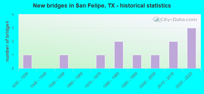
- New bridges - historical statistics
- 11930-1939
- 11950-1959
- 11970-1979
- 21980-1989
- 11990-1999
- 12000-2009
- 22010-2019
- 32020-2022


- Bridge Condition - Deck
- 25.0%Very good
- 25.0%Good
- 50.0%Satisfactory

- Bridge Condition - Superstructure
- 50.0%Very good
- 12.5%Good
- 25.0%Satisfactory
- 12.5%Fair

- Bridge Condition - Substructure
- 62.5%Good
- 25.0%Satisfactory
- 12.5%Critical

- Bridge Condition - Channel
- 40.0%Good
- 10.0%Satisfactory
- 30.0%Fair
- 10.0%Poor
- 10.0%Serious
Find on map >> Show street view
Structure Number: 122370052702017, Location: 2.60 MI N OF IH 10 (Lat: 29.807836, Lng: -96.096683), Route carried "on" structure: State highway 1458, Year Built: 1972, Status: Open, Structure Length: 30.48m (100.00ft), Average Daily Traffic: 1,451 (year 2020), Truck Traffic: 16%, Average Future Daily Traffic: 2,070 (year 2033), Design Load: HS 20, Features Intersected: BRAZOS RIVER
Minimum Vertical Clearance: 30+ m (98+ ft), Kilometerpoint: 13.354, Lanes on structure: 2, Owner: State Highway Agency, Approaching Roadway Width: 7.9m (25.9ft), Material/Design: Steel continuous, Design/Construction: Stringer/Multi-beam, Number Of Spans In Main Unit: 4, Number Of Approach Spans: 4, Length of Maximum Span: 57.9m (190.0ft), Curb-To-Curb Width: 10.4m (34.1ft), Out-to-Out Width: 11.1m (36.4ft)
Condition: Deck: Satisfactory, Superstructure: Fair, Substructure: Good, Channel: Fair, Operating Rating: 34.5 metric tons, Method Used To Determine Operating Rating: Load Factor (LF), Inventory Rating: 19.0 metric tons, Method Used To Determine Inventory Rating: Load Factor (LF), Structural Evaluation: Somewhat better than minimum adequacy, Deck Geometry: Equal to present minimum criteria, Waterway Adequacy: Equal to present minimum criteria, Approach Roadway Alignment: Equal to present desirable criteria, Length Of Structure Improvement: 6705.60m (22000.00ft), Designated Inspection Frequency: Every 24 months, Critical Feature Inspection Frequency: Every 24 months, Underwater Inspection Frequency: Every 60 months, Inspection Date: September 2020, Critical Feature Inspection Date: June 2020, Underwater Inspection Date: March 2018, Deck Structure Type: Concrete Cast-file-Place
Find on map >> Show street view
Structure Number: 122370AA0113001, Location: 1.80 MI W OF FM 1458 (Lat: 29.845217, Lng: -96.057394), Route carried "on" structure: County highway , Year Built: 2010, Status: Open, Structure Length: 8.29m (27.20ft), Average Daily Traffic: 160 (year 2010), Average Future Daily Traffic: 160 (year 2030), Design Load: HL 93, Features Intersected: IRONS CREEK, Facility Carried by Structure: GARRETT RD
Minimum Vertical Clearance: 30+ m (98+ ft), Kilometerpoint: 3.235, Lanes on structure: 2, Owner: County Highway Agency, Approaching Roadway Width: 6.1m (20.0ft), Material/Design: Prestressed concrete, Number Of Spans In Main Unit: 8, Length of Maximum Span: 11.9m (39.0ft), Curb-To-Curb Width: 8.5m (27.9ft), Out-to-Out Width: 9.2m (30.2ft)
Condition: Deck: Very good, Superstructure: Very good, Substructure: Good, Channel: Good, Operating Rating: 54.4 metric tons, Method Used To Determine Operating Rating: Assigned ratings based on Load and Resistance Factor Design (LRFD) reported in metric tons, Inventory Rating: 32.7 metric tons, Method Used To Determine Inventory Rating: Assigned ratings based on Load and Resistance Factor Design (LRFD) reported in metric tons, Structural Evaluation: Better than present minimum criteria, Deck Geometry: Equal to present minimum criteria, Waterway Adequacy: Equal to present desirable criteria, Approach Roadway Alignment: High priority of corrective action, Designated Inspection Frequency: Every 24 months, Inspection Date: October 2021, Deck Structure Type: Concrete Cast-file-Place
Find on map >> Show street view
Structure Number: 130080027103772, Location: 0.35 MI E OF FM 1458 (Lat: 29.776292, Lng: -96.103369), Route carried "on" structure: Interstate 10, Year Built: 2020, Status: Open, Structure Length: 1.49m (4.89ft), Average Daily Traffic: 65,213 (year 2019), Truck Traffic: 21%, Average Future Daily Traffic: 91,298 (year 2039), Design Load: HL 93, Features Intersected: DRAW
Minimum Vertical Clearance: 0.00m, Kilometerpoint: 19.439, Lanes on structure: 12, Owner: State Highway Agency, Approaching Roadway Width: 19.5m (64.0ft), Skew: 1 degrees, Material/Design: Concrete, Design/Construction: Culvert, Number Of Spans In Main Unit: 5, Length of Maximum Span: 2.1m (6.9ft), Curb-To-Curb Width: 19.5m (64.0ft), Out-to-Out Width: 97.5m (319.9ft)
Condition: Channel: Good, Culverts: Satisfactory, Operating Rating: 54.4 metric tons, Method Used To Determine Operating Rating: Assigned ratings based on Load and Resistance Factor Design (LRFD) reported in metric tons, Inventory Rating: 32.7 metric tons, Method Used To Determine Inventory Rating: Assigned ratings based on Load and Resistance Factor Design (LRFD) reported in metric tons, Structural Evaluation: Equal to present minimum criteria, Deck Geometry: High priority of replacement, Waterway Adequacy: Better than present minimum criteria, Approach Roadway Alignment: Equal to present desirable criteria, Designated Inspection Frequency: Every 24 months, Inspection Date: January 2021
Find on map >> Show street view
Structure Number: 130080027103775, Location: 2.80 MI E OF SH 36 (Lat: 29.776092, Lng: -96.109039), Route carried "on" structure: Interstate 1458, Year Built: 2021, Status: Open, Structure Length: 10.73m (35.20ft), Average Daily Traffic: 56,725 (year 2018), Truck Traffic: 25%, Average Future Daily Traffic: 93,162 (year 2038), Design Load: HL 93, Features Intersected: FM 1458, Facility Carried by Structure: IH 10
Minimum Vertical Clearance: 0.00m, Kilometerpoint: 18.829, Lanes on structure: 8, Lanes under structure: 6, Base Highway Network: Yes, Owner: State Highway Agency, Approaching Roadway Width: 22.3m (73.2ft), Material/Design: Prestressed concrete, Design/Construction: Stringer/Multi-beam, Number Of Spans In Main Unit: 3, Length of Maximum Span: 36.6m (120.1ft), Curb-To-Curb Width: 22.3m (73.2ft), Out-to-Out Width: 45.9m (150.6ft)
Condition: Deck: Very good, Superstructure: Very good, Substructure: Good, Operating Rating: 54.4 metric tons, Method Used To Determine Operating Rating: Assigned ratings based on Load and Resistance Factor Design (LRFD) reported in metric tons, Inventory Rating: 32.7 metric tons, Method Used To Determine Inventory Rating: Assigned ratings based on Load and Resistance Factor Design (LRFD) reported in metric tons, Structural Evaluation: Better than present minimum criteria, Deck Geometry: High priority of replacement, Underclear: Superior to present desirable criteria, Approach Roadway Alignment: Equal to present desirable criteria, Designated Inspection Frequency: Every 24 months, Inspection Date: March 2021, Deck Structure Type: Concrete Cast-file-Place
Find on map >> Show street view
Structure Number: 130080052701023, Location: 0.40 MI N OF IH 10 (Lat: 29.781522, Lng: -96.107042), Route carried "on" structure: State highway 1458, Year Built: 1938, Status: Open, Structure Length: 1.43m (4.69ft), Average Daily Traffic: 2,630 (year 2020), Truck Traffic: 13%, Average Future Daily Traffic: 3,620 (year 2038), Features Intersected: DRAW
Minimum Vertical Clearance: 30+ m (98+ ft), Kilometerpoint: 4.723, Lanes on structure: 2, Owner: State Highway Agency, Approaching Roadway Width: 7.9m (25.9ft), Material/Design: Concrete, Design/Construction: Culvert, Number Of Spans In Main Unit: 7, Length of Maximum Span: 1.8m (5.9ft), Curb-To-Curb Width: 10.3m (33.8ft), Out-to-Out Width: 11.3m (37.1ft)
Condition: Channel: Good, Culverts: Satisfactory, Operating Rating: 39.9 metric tons, Method Used To Determine Operating Rating: Load Factor (LF), Inventory Rating: 23.6 metric tons, Method Used To Determine Inventory Rating: Load Factor (LF), Structural Evaluation: Equal to present minimum criteria, Deck Geometry: Meets minimum limits, Waterway Adequacy: Equal to present minimum criteria, Approach Roadway Alignment: Equal to present desirable criteria, Designated Inspection Frequency: Every 24 months, Inspection Date: January 2021, Deck Structure Type: Concrete Cast-file-Place, Wearing Surface/Protective System: Wearing Surface: Bituminous
Find on map >> Show street view
Structure Number: 130080052703001, Location: 0.60 MI SE OF IH 10 (Lat: 29.768808, Lng: -96.103683), Route carried "on" structure: State highway 1458, Year Built: 1951, Status: Open, Structure Length: 1.01m (3.31ft), Average Daily Traffic: 1,177 (year 2020), Truck Traffic: 27%, Average Future Daily Traffic: 1,648 (year 2040), Features Intersected: DRAW
Minimum Vertical Clearance: 30+ m (98+ ft), Kilometerpoint: 1.032, Lanes on structure: 2, Owner: State Highway Agency, Approaching Roadway Width: 7.0m (23.0ft), Material/Design: Concrete, Design/Construction: Culvert, Number Of Spans In Main Unit: 5, Length of Maximum Span: 1.8m (5.9ft), Curb-To-Curb Width: 7.0m (23.0ft), Out-to-Out Width: 8.9m (29.2ft)
Condition: Channel: Good, Culverts: Satisfactory, Operating Rating: 39.9 metric tons, Method Used To Determine Operating Rating: Load Factor (LF), Inventory Rating: 23.6 metric tons, Method Used To Determine Inventory Rating: Load Factor (LF), Structural Evaluation: Equal to present minimum criteria, Deck Geometry: High priority of corrective action, Waterway Adequacy: Equal to present minimum criteria, Approach Roadway Alignment: Equal to present desirable criteria, Designated Inspection Frequency: Every 24 months, Inspection Date: January 2021, Deck Structure Type: Concrete Cast-file-Place, Wearing Surface/Protective System: Wearing Surface: Bituminous
Find on map >> Show street view
Structure Number: 130080052707244, Location: 0.98 MI W OF FM 1458 (Lat: 29.813661, Lng: -96.108397), Route carried "on" structure: State highway 38, Year Built: 2016, Status: Open, Structure Length: 3.41m (11.19ft), Average Daily Traffic: 320 (year 2013), Truck Traffic: 2%, Average Future Daily Traffic: 450 (year 2033), Design Load: HL 93, Features Intersected: BULLINGER CRK
Minimum Vertical Clearance: 30+ m (98+ ft), Kilometerpoint: 1.582, Lanes on structure: 2, Owner: State Highway Agency, Approaching Roadway Width: 6.1m (20.0ft), Material/Design: Prestressed concrete, Design/Construction: Stringer/Multi-beam, Number Of Spans In Main Unit: 1, Length of Maximum Span: 34.1m (111.9ft), Curb-To-Curb Width: 9.9m (32.5ft), Out-to-Out Width: 10.5m (34.4ft)
Condition: Deck: Satisfactory, Superstructure: Very good, Substructure: Good, Channel: Satisfactory, Operating Rating: 54.4 metric tons, Method Used To Determine Operating Rating: Assigned ratings based on Load and Resistance Factor Design (LRFD) reported in metric tons, Inventory Rating: 32.7 metric tons, Method Used To Determine Inventory Rating: Assigned ratings based on Load and Resistance Factor Design (LRFD) reported in metric tons, Structural Evaluation: Better than present minimum criteria, Deck Geometry: Better than present minimum criteria, Waterway Adequacy: Superior to present desirable criteria, Approach Roadway Alignment: Equal to present desirable criteria, Designated Inspection Frequency: Every 24 months, Inspection Date: Febuary 2021, Deck Structure Type: Concrete Precast Panels
Find on map >> Show street view
Structure Number: 130080AA0314001, Location: 2.9 MI NE OF SH 36 (Lat: 29.860811, Lng: -96.139936), Route carried "on" structure: County highway , Year Built: 1980, Status: Open, Structure Length: 6.46m (21.19ft), Average Daily Traffic: 130 (year 2012), Average Future Daily Traffic: 200 (year 2032), Features Intersected: MILL CREEK, Facility Carried by Structure: GRUBBS RD
Minimum Vertical Clearance: 30+ m (98+ ft), Kilometerpoint: 4.587, Lanes on structure: 2, Owner: County Highway Agency, Approaching Roadway Width: 4.9m (16.1ft), Material/Design: Prestressed concrete, Design/Construction: Box Beam or Girders - Multiple, Number Of Spans In Main Unit: 5, Length of Maximum Span: 12.8m (42.0ft), Curb-To-Curb Width: 7.3m (24.0ft), Out-to-Out Width: 7.9m (25.9ft)
Condition: Deck: Satisfactory, Superstructure: Satisfactory, Substructure: Critical, Channel: Serious, Operating Rating: 32.7 metric tons, Method Used To Determine Operating Rating: Field evaluation and documented engineering judgment, Inventory Rating: 24.5 metric tons, Method Used To Determine Inventory Rating: Field evaluation and documented engineering judgment, Structural Evaluation: High priority of replacement, Deck Geometry: Somewhat better than minimum adequacy, Waterway Adequacy: Equal to present minimum criteria, Approach Roadway Alignment: Somewhat better than minimum adequacy, Length Of Structure Improvement: 2.56m (8.40ft), Designated Inspection Frequency: Every 6 months, Inspection Date: July 2021, Total Project Cost: $1,275,000, Deck Structure Type: Concrete Cast-file-Place
Find on map >> Show street view
Structure Number: 130080AA0372001, Location: 0.9 MI SW OF PETERS-SANFL (Lat: 29.808036, Lng: -96.136328), Route carried "on" structure: County highway , Year Built: 1986, Status: Open, Structure Length: 1.22m (4.00ft), Average Daily Traffic: 40 (year 2013), Average Future Daily Traffic: 80 (year 2035), Features Intersected: BULLINGER CREEK, Facility Carried by Structure: REMMERT RD
Minimum Vertical Clearance: 30+ m (98+ ft), Kilometerpoint: 9.576, Lanes on structure: 2, Owner: County Highway Agency, Approaching Roadway Width: 6.1m (20.0ft), Material/Design: Prestressed concrete, Design/Construction: Box Beam or Girders - Multiple, Number Of Spans In Main Unit: 1, Length of Maximum Span: 12.2m (40.0ft), Curb-To-Curb Width: 6.1m (20.0ft), Out-to-Out Width: 6.7m (22.0ft)
Condition: Deck: Good, Superstructure: Very good, Substructure: Satisfactory, Channel: Fair, Operating Rating: 32.7 metric tons, Method Used To Determine Operating Rating: Field evaluation and documented engineering judgment, Inventory Rating: 24.5 metric tons, Method Used To Determine Inventory Rating: Field evaluation and documented engineering judgment, Structural Evaluation: Equal to present minimum criteria, Deck Geometry: Somewhat better than minimum adequacy, Waterway Adequacy: Better than present minimum criteria, Approach Roadway Alignment: Equal to present desirable criteria, Length Of Structure Improvement: 1.22m (4.00ft), Designated Inspection Frequency: Every 24 months, Inspection Date: January 2020, Deck Structure Type: Concrete Cast-file-Place, Wearing Surface/Protective System: Wearing Surface: Gravel
Find on map >> Show street view
Structure Number: 130080AA5101002, Location: 2.2 MI NE OF SH 36 (Lat: 29.813239, Lng: -96.144744), Route carried "on" structure: County highway , Year Built: 2007, Status: Open, Structure Length: 0.73m (2.40ft), Average Daily Traffic: 50 (year 2013), Average Future Daily Traffic: 80 (year 2035), Features Intersected: DRAW, Facility Carried by Structure: MALER RD
Minimum Vertical Clearance: 30+ m (98+ ft), Kilometerpoint: 1.287, Lanes on structure: 2, Owner: County Highway Agency, Approaching Roadway Width: 4.9m (16.1ft), Material/Design: Steel, Design/Construction: Stringer/Multi-beam, Number Of Spans In Main Unit: 1, Length of Maximum Span: 7.0m (23.0ft), Curb-To-Curb Width: 7.2m (23.6ft), Out-to-Out Width: 7.3m (24.0ft)
Condition: Deck: Good, Superstructure: Good, Substructure: Good, Channel: Fair, Operating Rating: 68.0 metric tons, Method Used To Determine Operating Rating: Allowable Stress (AS), Inventory Rating: 40.8 metric tons, Method Used To Determine Inventory Rating: Allowable Stress (AS), Structural Evaluation: Better than present minimum criteria, Deck Geometry: Somewhat better than minimum adequacy, Waterway Adequacy: Better than present minimum criteria, Approach Roadway Alignment: Equal to present desirable criteria, Designated Inspection Frequency: Every 24 months, Inspection Date: January 2020, Deck Structure Type: Concrete Cast-file-Place
Find on map >> Show street view
Structure Number: 130080E00150001, Location: 0.40 MI NW OF PEACH ST (Lat: 29.811406, Lng: -96.114539), Route carried "on" structure: City street , Year Built: 1996, Status: Closed, Structure Length: 3.35m (10.99ft), Average Daily Traffic: 230 (year 2012), Average Future Daily Traffic: 300 (year 2032), Design Load: HS 20, Features Intersected: BULLINGER CREEK, Facility Carried by Structure: PETERS-SAN FELIPE
Minimum Vertical Clearance: 30+ m (98+ ft), Kilometerpoint: 0.644, Lanes on structure: 2, Owner: City or Municipal Highway Agency, Approaching Roadway Width: 4.9m (16.1ft), Skew: 3 degrees, Material/Design: Prestressed concrete, Design/Construction: Stringer/Multi-beam, Number Of Spans In Main Unit: 3, Length of Maximum Span: 12.2m (40.0ft), Curb-To-Curb Width: 7.2m (23.6ft), Out-to-Out Width: 7.9m (25.9ft)
Condition: Deck: Satisfactory, Superstructure: Satisfactory, Substructure: Satisfactory, Channel: Poor, Deck Geometry: Meets minimum limits, Waterway Adequacy: Equal to present desirable criteria, Approach Roadway Alignment: Better than present minimum criteria, Bridge Posting: Required (Relationship of Operating Rating to Maximum Legal Load: > 39.9% below), Designated Inspection Frequency: Every 24 months, Inspection Date: January 2020, Deck Structure Type: Concrete Precast Panels
Find on map >> Show street view
Structure Number: 130080027103775, Location: 2.80 MI E OF SH 36 (Lat: 29.776092, Lng: -96.109039), Route carried "under" structure: State highway 1458, Year Built: 2021, Structure Length: 0. m, Average Daily Traffic: 4,000 (year 2018), Truck Traffic: 5%, Features Intersected: IH 10, Facility Carried by Structure: IH 10
Minimum Vertical Clearance: 5.06m (16.60ft), Kilometerpoint: 18.829, Lanes on structure: 6, Material/Design: Prestressed concrete, Design/Construction: Stringer/Multi-beam, Length of Maximum Span: 36.6m (120.1ft)