Bridge Statistics for San Juan, Texas (TX)
Condition, Traffic, Stress, Structural Evaluation, Project Costs
- National Bridge Inventory (NBI) Statistics
- 24Number of bridges
- 240ft / 73.3mTotal length
- $15,000Total costs
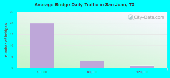
- 373,321Total average daily traffic
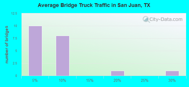
- 25,212Total average daily truck traffic
- National Bridge Inventory (NBI) Registered Bridges for San Juan
- No street view available for this location
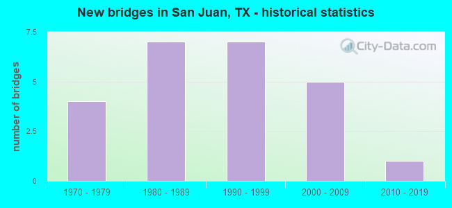
- New bridges - historical statistics
- 41970-1979
- 71980-1989
- 71990-1999
- 52000-2009
- 12010-2019
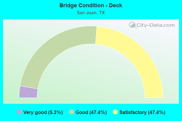
- Bridge Condition - Deck
- 5.3%Very good
- 47.4%Good
- 47.4%Satisfactory
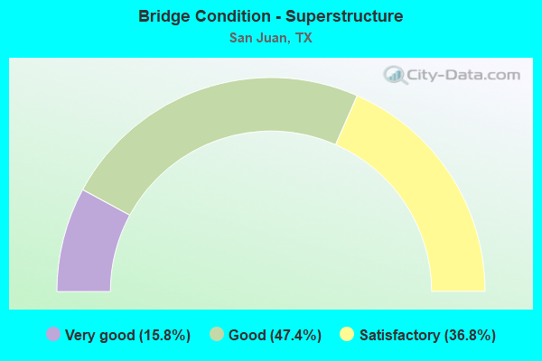
- Bridge Condition - Superstructure
- 15.8%Very good
- 47.4%Good
- 36.8%Satisfactory
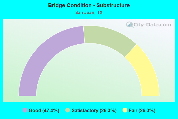
- Bridge Condition - Substructure
- 47.4%Good
- 26.3%Satisfactory
- 26.3%Fair
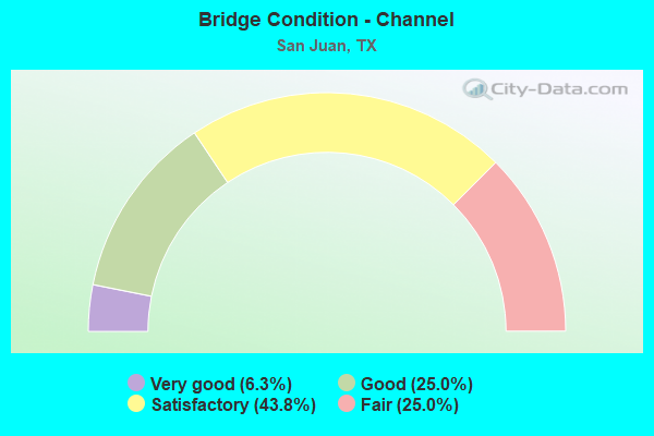
- Bridge Condition - Channel
- 6.3%Very good
- 25.0%Good
- 43.8%Satisfactory
- 25.0%Fair
Find on map >> Show street view
Structure Number: 21109000391726, Location: 1.9 MI E OF US 281 (Lat: 26.199225, Lng: -98.153478), Route carried "on" structure: US 83, Year Built: 1998, Status: Open, Structure Length: 7.92m (25.98ft), Average Daily Traffic: 48,110 (year 2011), Truck Traffic: 7%, Average Future Daily Traffic: 67,350 (year 2031), Design Load: HS 20, Features Intersected: FM 1426 (NEBRASKA ST.)
Minimum Vertical Clearance: 30+ m (98+ ft), Kilometerpoint: 47.151, Lanes on structure: 4, Lanes under structure: 8, Owner: State Highway Agency, Approaching Roadway Width: 20.1m (65.9ft), Skew: 2 degrees, Material/Design: Prestressed concrete, Design/Construction: Stringer/Multi-beam, Number Of Spans In Main Unit: 1, Number Of Approach Spans: 2, Length of Maximum Span: 37.2m (122.0ft), Curb-To-Curb Width: 20.2m (66.3ft), Out-to-Out Width: 21.0m (68.9ft)
Condition: Deck: Good, Superstructure: Very good, Substructure: Good, Operating Rating: 54.4 metric tons, Method Used To Determine Operating Rating: Assigned rating based on Load Factor Design (LFD) reported in metric tons, Inventory Rating: 32.7 metric tons, Method Used To Determine Inventory Rating: Assigned rating based on Load Factor Design (LFD) reported in metric tons, Structural Evaluation: Better than present minimum criteria, Deck Geometry: Equal to present minimum criteria, Underclear: Equal to present minimum criteria, Approach Roadway Alignment: Equal to present desirable criteria, Designated Inspection Frequency: Every 24 months, Inspection Date: May 2021, Deck Structure Type: Concrete Precast Panels
Find on map >> Show street view
Structure Number: 211090003917261, Location: 1.9 MI E OF US 281 (Lat: 26.199214, Lng: -98.154192), Route carried "on" structure: US 83, Year Built: 1997, Status: Open, Structure Length: 7.92m (25.98ft), Average Daily Traffic: 48,110 (year 2011), Truck Traffic: 7%, Average Future Daily Traffic: 67,350 (year 2031), Design Load: HS 20, Features Intersected: FM 1426 (NEBRASKA ST)
Minimum Vertical Clearance: 30+ m (98+ ft), Kilometerpoint: 47.151, Lanes on structure: 4, Lanes under structure: 8, Owner: State Highway Agency, Approaching Roadway Width: 20.1m (65.9ft), Skew: 2 degrees, Material/Design: Prestressed concrete, Design/Construction: Stringer/Multi-beam, Number Of Spans In Main Unit: 1, Number Of Approach Spans: 2, Length of Maximum Span: 37.2m (122.0ft), Curb-To-Curb Width: 20.2m (66.3ft), Out-to-Out Width: 21.0m (68.9ft)
Condition: Deck: Good, Superstructure: Good, Substructure: Good, Operating Rating: 54.4 metric tons, Method Used To Determine Operating Rating: Assigned rating based on Load Factor Design (LFD) reported in metric tons, Inventory Rating: 32.7 metric tons, Method Used To Determine Inventory Rating: Assigned rating based on Load Factor Design (LFD) reported in metric tons, Structural Evaluation: Better than present minimum criteria, Deck Geometry: Equal to present minimum criteria, Underclear: Equal to present minimum criteria, Approach Roadway Alignment: Equal to present desirable criteria, Designated Inspection Frequency: Every 24 months, Inspection Date: May 2021, Deck Structure Type: Concrete Precast Panels
Find on map >> Show street view
Structure Number: 211090003917262, Location: 1.0 MI E OF US 281 (Lat: 26.204639, Lng: -98.165125), Route carried "on" structure: US 83, Year Built: 1998, Status: Open, Structure Length: 6.95m (22.80ft), Average Daily Traffic: 58,180 (year 2011), Truck Traffic: 6%, Average Future Daily Traffic: 81,460 (year 2031), Design Load: HS 20, Features Intersected: NORTH I ROAD
Minimum Vertical Clearance: 30+ m (98+ ft), Kilometerpoint: 45.847, Lanes on structure: 4, Lanes under structure: 8, Owner: State Highway Agency, Approaching Roadway Width: 20.4m (66.9ft), Material/Design: Prestressed concrete, Design/Construction: Box Beam or Girders - Multiple, Number Of Spans In Main Unit: 1, Number Of Approach Spans: 2, Length of Maximum Span: 33.5m (109.9ft), Curb-To-Curb Width: 20.3m (66.6ft), Out-to-Out Width: 21.0m (68.9ft)
Condition: Deck: Good, Superstructure: Good, Substructure: Good, Operating Rating: 54.4 metric tons, Method Used To Determine Operating Rating: Assigned rating based on Load Factor Design (LFD) reported in metric tons, Inventory Rating: 32.7 metric tons, Method Used To Determine Inventory Rating: Assigned rating based on Load Factor Design (LFD) reported in metric tons, Structural Evaluation: Better than present minimum criteria, Deck Geometry: Equal to present minimum criteria, Underclear: Better than present minimum criteria, Approach Roadway Alignment: Equal to present desirable criteria, Designated Inspection Frequency: Every 24 months, Inspection Date: May 2021, Deck Structure Type: Concrete Cast-file-Place
Find on map >> Show street view
Structure Number: 211090003918282, Location: 3.2 MI E OF US 281 (Lat: 26.192739, Lng: -98.134214), Route carried "on" structure: US 83, Year Built: 2002, Status: Open, Structure Length: 6.95m (22.80ft), Average Daily Traffic: 105,149 (year 2018), Truck Traffic: 9%, Average Future Daily Traffic: 90,000 (year 2033), Design Load: HS 20, Features Intersected: CESAR CHAVEZ ROAD
Minimum Vertical Clearance: 30+ m (98+ ft), Kilometerpoint: 49.307, Lanes on structure: 4, Lanes under structure: 6, Owner: State Highway Agency, Approaching Roadway Width: 20.4m (66.9ft), Material/Design: Prestressed concrete, Design/Construction: Stringer/Multi-beam, Number Of Spans In Main Unit: 1, Number Of Approach Spans: 2, Length of Maximum Span: 33.5m (109.9ft), Curb-To-Curb Width: 20.3m (66.6ft), Out-to-Out Width: 21.0m (68.9ft)
Condition: Deck: Good, Superstructure: Very good, Substructure: Good, Operating Rating: 54.4 metric tons, Method Used To Determine Operating Rating: Assigned rating based on Load Factor Design (LFD) reported in metric tons, Inventory Rating: 32.7 metric tons, Method Used To Determine Inventory Rating: Assigned rating based on Load Factor Design (LFD) reported in metric tons, Structural Evaluation: Better than present minimum criteria, Deck Geometry: Equal to present minimum criteria, Underclear: Better than present minimum criteria, Approach Roadway Alignment: Equal to present desirable criteria, Designated Inspection Frequency: Every 24 months, Inspection Date: May 2021, Deck Structure Type: Concrete Precast Panels
Find on map >> Show street view
Structure Number: 211090142901005, Location: 0.90 MI N OF US 281 (Lat: 26.103042, Lng: -98.161406), Route carried "on" structure: State highway 2557, Year Built: 1990, Year Reconstructed: 2012, Status: Open, Structure Length: 2.29m (7.51ft), Average Daily Traffic: 2,668 (year 2014), Truck Traffic: 26%, Average Future Daily Traffic: 2,100 (year 2032), Design Load: HS 20, Features Intersected: HCWID #1 MASTER DRAIN
Minimum Vertical Clearance: 30+ m (98+ ft), Kilometerpoint: 25.622, Lanes on structure: 2, Owner: State Highway Agency, Approaching Roadway Width: 12.2m (40.0ft), Material/Design: Prestressed concrete, Number Of Spans In Main Unit: 2, Length of Maximum Span: 12.2m (40.0ft), Curb-To-Curb Width: 13.9m (45.6ft), Out-to-Out Width: 14.6m (47.9ft)
Condition: Deck: Very good, Superstructure: Good, Substructure: Good, Channel: Good, Operating Rating: 54.4 metric tons, Method Used To Determine Operating Rating: Assigned rating based on Load Factor Design (LFD) reported in metric tons, Inventory Rating: 32.7 metric tons, Method Used To Determine Inventory Rating: Assigned rating based on Load Factor Design (LFD) reported in metric tons, Structural Evaluation: Better than present minimum criteria, Deck Geometry: Superior to present desirable criteria, Waterway Adequacy: Equal to present minimum criteria, Approach Roadway Alignment: Equal to present desirable criteria, Designated Inspection Frequency: Every 24 months, Inspection Date: April 2021, Deck Structure Type: Other, Wearing Surface/Protective System: Wearing Surface: Bituminous
Find on map >> Show street view
Structure Number: 211090142901026, Location: 2.5 MI S OF BUS 83 (Lat: 26.151017, Lng: -98.151350), Route carried "on" structure: State highway 2557, Year Built: 2012, Status: Open, Structure Length: 4.88m (16.01ft), Average Daily Traffic: 4,850 (year 2020), Truck Traffic: 15%, Average Future Daily Traffic: 9,200 (year 2032), Design Load: HL 93, Features Intersected: MAIN FLOODWAY PILOT CHAN
Minimum Vertical Clearance: 30+ m (98+ ft), Kilometerpoint: 20.004, Lanes on structure: 2, Owner: State Highway Agency, Approaching Roadway Width: 13.4m (44.0ft), Skew: 4 degrees, Material/Design: Prestressed concrete, Design/Construction: Stringer/Multi-beam, Number Of Spans In Main Unit: 3, Length of Maximum Span: 18.3m (60.0ft), Curb-To-Curb Width: 13.3m (43.6ft), Out-to-Out Width: 14.0m (45.9ft)
Condition: Deck: Good, Superstructure: Very good, Substructure: Good, Channel: Very good, Operating Rating: 54.4 metric tons, Method Used To Determine Operating Rating: Assigned ratings based on Load and Resistance Factor Design (LRFD) reported in metric tons, Inventory Rating: 32.7 metric tons, Method Used To Determine Inventory Rating: Assigned ratings based on Load and Resistance Factor Design (LRFD) reported in metric tons, Structural Evaluation: Better than present minimum criteria, Deck Geometry: Equal to present minimum criteria, Waterway Adequacy: Equal to present minimum criteria, Approach Roadway Alignment: Equal to present desirable criteria, Designated Inspection Frequency: Every 24 months, Inspection Date: May 2021, Deck Structure Type: Concrete Precast Panels
Find on map >> Show street view
Structure Number: 211090158601006, Location: 1.05 MI N OF US 281 (Lat: 26.101428, Lng: -98.137275), Route carried "on" structure: State highway 907, Year Built: 1989, Status: Open, Structure Length: 2.29m (7.51ft), Average Daily Traffic: 4,389 (year 2019), Truck Traffic: 5%, Average Future Daily Traffic: 3,120 (year 2033), Design Load: HS 20, Features Intersected: HCWID #1 MASTER DRAIN
Minimum Vertical Clearance: 30+ m (98+ ft), Kilometerpoint: 27.148, Lanes on structure: 2, Owner: State Highway Agency, Approaching Roadway Width: 12.2m (40.0ft), Skew: 1 degrees, Material/Design: Concrete continuous, Design/Construction: Slab, Number Of Spans In Main Unit: 3, Length of Maximum Span: 7.6m (24.9ft), Curb-To-Curb Width: 10.2m (33.5ft), Out-to-Out Width: 11.0m (36.1ft)
Condition: Deck: Good, Superstructure: Good, Substructure: Good, Channel: Satisfactory, Operating Rating: 68.0 metric tons, Method Used To Determine Operating Rating: Load Factor (LF), Inventory Rating: 40.8 metric tons, Method Used To Determine Inventory Rating: Load Factor (LF), Structural Evaluation: Better than present minimum criteria, Deck Geometry: Meets minimum limits, Waterway Adequacy: Equal to present minimum criteria, Approach Roadway Alignment: Equal to present desirable criteria, Designated Inspection Frequency: Every 24 months, Inspection Date: April 2021, Deck Structure Type: Concrete Cast-file-Place
Find on map >> Show street view
Structure Number: 211090180202005, Location: 1.50 MI E OF US 281 (Lat: 26.229903, Lng: -98.153347), Route carried "on" structure: State highway 3461, Year Built: 1989, Year Reconstructed: 2014, Status: Open, Structure Length: 2.77m (9.09ft), Average Daily Traffic: 12,612 (year 2020), Truck Traffic: 2%, Average Future Daily Traffic: 25,230 (year 2033), Design Load: H 20, Features Intersected: PHARR-S.JUAN-MCALL. LATR
Minimum Vertical Clearance: 30+ m (98+ ft), Kilometerpoint: 5.385, Lanes on structure: 4, Owner: State Highway Agency, Approaching Roadway Width: 23.2m (76.1ft), Skew: 20 degrees, Material/Design: Concrete, Design/Construction: Stringer/Multi-beam, Number Of Spans In Main Unit: 3, Length of Maximum Span: 9.1m (29.9ft), Curb or Sidewalk Widths: Left: 1.8m (5.9ft), Right: 1.8m (5.9ft), Curb-To-Curb Width: 23.6m (77.4ft), Out-to-Out Width: 31.9m (104.7ft)
Condition: Deck: Good, Superstructure: Good, Substructure: Good, Channel: Good, Operating Rating: 68.0 metric tons, Method Used To Determine Operating Rating: Load Factor (LF), Inventory Rating: 40.8 metric tons, Method Used To Determine Inventory Rating: Load Factor (LF), Structural Evaluation: Better than present minimum criteria, Deck Geometry: Superior to present desirable criteria, Waterway Adequacy: Equal to present minimum criteria, Approach Roadway Alignment: Equal to present desirable criteria, Designated Inspection Frequency: Every 24 months, Inspection Date: May 2021, Deck Structure Type: Concrete Cast-file-Place, Wearing Surface/Protective System: Wearing Surface: Bituminous
Find on map >> Show street view
Structure Number: 211090AA0652001, Location: 0.10 MI W OF FM 907 (Lat: 26.100747, Lng: -98.138964), Route carried "on" structure: County highway , Year Built: 1975, Status: Posted for load, Structure Length: 1.92m (6.30ft), Average Daily Traffic: 100 (year 2010), Average Future Daily Traffic: 75 (year 2032), Features Intersected: S FLOODWATER CHANNEL, Facility Carried by Structure: ANAYA ROAD
Minimum Vertical Clearance: 30+ m (98+ ft), Kilometerpoint: 0.161, Lanes on structure: 2, Owner: County Highway Agency, Approaching Roadway Width: 4.3m (14.1ft), Material/Design: Concrete, Design/Construction: Stringer/Multi-beam, Number Of Spans In Main Unit: 2, Length of Maximum Span: 9.1m (29.9ft), Curb-To-Curb Width: 6.8m (22.3ft), Out-to-Out Width: 7.6m (24.9ft)
Condition: Deck: Satisfactory, Superstructure: Good, Substructure: Fair, Channel: Fair, Operating Rating: 32.7 metric tons, Method Used To Determine Operating Rating: Field evaluation and documented engineering judgment, Inventory Rating: 24.5 metric tons, Method Used To Determine Inventory Rating: Field evaluation and documented engineering judgment, Structural Evaluation: Somewhat better than minimum adequacy, Deck Geometry: Somewhat better than minimum adequacy, Waterway Adequacy: Better than present minimum criteria, Approach Roadway Alignment: Equal to present desirable criteria, Bridge Posting: Required (Relationship of Operating Rating to Maximum Legal Load: 10.0 - 19.9% below), Designated Inspection Frequency: Every 24 months, Inspection Date: April 2020, Deck Structure Type: Concrete Cast-file-Place
Find on map >> Show street view
Structure Number: 211090AA0652002, Location: 0.25 MI W OF JCT FM 2557 (Lat: 26.104406, Lng: -98.165406), Route carried "on" structure: County highway , Year Built: 1975, Status: Posted for load, Structure Length: 1.92m (6.30ft), Average Daily Traffic: 70 (year 2010), Average Future Daily Traffic: 75 (year 2032), Features Intersected: S FLOODWATER CHANNEL, Facility Carried by Structure: ANAYA ROAD
Minimum Vertical Clearance: 30+ m (98+ ft), Kilometerpoint: 2.816, Lanes on structure: 2, Owner: County Highway Agency, Approaching Roadway Width: 5.5m (18.0ft), Material/Design: Concrete, Design/Construction: Stringer/Multi-beam, Number Of Spans In Main Unit: 2, Length of Maximum Span: 9.1m (29.9ft), Curb-To-Curb Width: 6.8m (22.3ft), Out-to-Out Width: 7.6m (24.9ft)
Condition: Deck: Satisfactory, Superstructure: Satisfactory, Substructure: Fair, Channel: Good, Operating Rating: 32.7 metric tons, Method Used To Determine Operating Rating: Field evaluation and documented engineering judgment, Inventory Rating: 24.5 metric tons, Method Used To Determine Inventory Rating: Field evaluation and documented engineering judgment, Structural Evaluation: Somewhat better than minimum adequacy, Deck Geometry: Somewhat better than minimum adequacy, Waterway Adequacy: Better than present minimum criteria, Approach Roadway Alignment: Equal to present desirable criteria, Bridge Posting: Required (Relationship of Operating Rating to Maximum Legal Load: 20.0 - 29.9% below), Designated Inspection Frequency: Every 24 months, Inspection Date: April 2020, Deck Structure Type: Concrete Cast-file-Place
Find on map >> Show street view
Structure Number: 211090AA0664001, Location: 0.70 MI N OF US 281 (Lat: 26.098631, Lng: -98.149961), Route carried "on" structure: County highway , Year Built: 1975, Status: Posted for load, Structure Length: 1.92m (6.30ft), Average Daily Traffic: 80 (year 2010), Average Future Daily Traffic: 120 (year 2032), Design Load: H 20, Features Intersected: S FLOODWATER CHANNEL, Facility Carried by Structure: CESAR CHAVEZ RD
Minimum Vertical Clearance: 30+ m (98+ ft), Kilometerpoint: 1.127, Lanes on structure: 2, Owner: County Highway Agency, Approaching Roadway Width: 6.1m (20.0ft), Material/Design: Concrete, Design/Construction: Stringer/Multi-beam, Number Of Spans In Main Unit: 2, Length of Maximum Span: 9.1m (29.9ft), Curb-To-Curb Width: 6.8m (22.3ft), Out-to-Out Width: 7.6m (24.9ft)
Condition: Deck: Satisfactory, Superstructure: Satisfactory, Substructure: Satisfactory, Channel: Satisfactory, Operating Rating: 68.0 metric tons, Method Used To Determine Operating Rating: Load Factor (LF), Inventory Rating: 40.8 metric tons, Method Used To Determine Inventory Rating: Load Factor (LF), Structural Evaluation: Equal to present minimum criteria, Deck Geometry: Somewhat better than minimum adequacy, Waterway Adequacy: Better than present minimum criteria, Approach Roadway Alignment: Equal to present desirable criteria, Bridge Posting: Required (Relationship of Operating Rating to Maximum Legal Load: 20.0 - 29.9% below), Designated Inspection Frequency: Every 24 months, Inspection Date: April 2020, Deck Structure Type: Concrete Cast-file-Place
Find on map >> Show street view
Structure Number: 211090AA0666001, Location: 1.35 MI N OF US 281 (Lat: 26.110444, Lng: -98.172342), Route carried "on" structure: County highway , Year Built: 1975, Status: Open, Structure Length: 1.92m (6.30ft), Average Daily Traffic: 60 (year 2010), Average Future Daily Traffic: 90 (year 2032), Features Intersected: S FLOODWATER CHANNEL, Facility Carried by Structure: SAN JUAN RD
Minimum Vertical Clearance: 30+ m (98+ ft), Kilometerpoint: 2.173, Lanes on structure: 2, Owner: County Highway Agency, Approaching Roadway Width: 5.5m (18.0ft), Material/Design: Concrete, Design/Construction: Stringer/Multi-beam, Number Of Spans In Main Unit: 2, Length of Maximum Span: 9.1m (29.9ft), Curb-To-Curb Width: 6.8m (22.3ft), Out-to-Out Width: 7.6m (24.9ft)
Condition: Deck: Satisfactory, Superstructure: Satisfactory, Substructure: Good, Channel: Satisfactory, Operating Rating: 32.7 metric tons, Method Used To Determine Operating Rating: Field evaluation and documented engineering judgment, Inventory Rating: 24.5 metric tons, Method Used To Determine Inventory Rating: Field evaluation and documented engineering judgment, Structural Evaluation: Equal to present minimum criteria, Deck Geometry: Somewhat better than minimum adequacy, Waterway Adequacy: Better than present minimum criteria, Approach Roadway Alignment: Equal to present desirable criteria, Designated Inspection Frequency: Every 24 months, Inspection Date: April 2020, Deck Structure Type: Concrete Cast-file-Place
Find on map >> Show street view
Structure Number: 211090R00596001, Location: 0.75 MI N OF FM 495 (Lat: 26.220117, Lng: -98.162817), Route carried "on" structure: City street , Year Built: 1989, Year Reconstructed: 2007, Status: Open, Structure Length: 2.77m (9.09ft), Average Daily Traffic: 17,209 (year 2019), Truck Traffic: 8%, Average Future Daily Traffic: 7,500 (year 2032), Design Load: HS 20, Features Intersected: PHARR-MCALLEN LATERAL, Facility Carried by Structure: N I RD (VET BLVD)
Minimum Vertical Clearance: 30+ m (98+ ft), Kilometerpoint: 1.207, Lanes on structure: 5, Owner: City or Municipal Highway Agency, Approaching Roadway Width: 25.0m (82.0ft), Material/Design: Concrete, Design/Construction: Stringer/Multi-beam, Number Of Spans In Main Unit: 3, Length of Maximum Span: 9.1m (29.9ft), Curb-To-Curb Width: 25.1m (82.3ft), Out-to-Out Width: 25.7m (84.3ft)
Condition: Deck: Satisfactory, Superstructure: Satisfactory, Substructure: Satisfactory, Channel: Satisfactory, Operating Rating: 60.8 metric tons, Method Used To Determine Operating Rating: Load Factor (LF), Inventory Rating: 36.3 metric tons, Method Used To Determine Inventory Rating: Load Factor (LF), Structural Evaluation: Equal to present minimum criteria, Deck Geometry: Superior to present desirable criteria, Waterway Adequacy: Superior to present desirable criteria, Approach Roadway Alignment: Equal to present desirable criteria, Designated Inspection Frequency: Every 24 months, Inspection Date: April 2020, Deck Structure Type: Concrete Cast-file-Place
Find on map >> Show street view
Structure Number: 211090R01030001, Location: 1.90 MI S OF BUS 83 (Lat: 26.164022, Lng: -98.172400), Route carried "on" structure: City street , Year Built: 2006, Status: Open, Structure Length: 2.44m (8.01ft), Average Daily Traffic: 8,446 (year 2019), Truck Traffic: 2%, Average Future Daily Traffic: 3,650 (year 2032), Features Intersected: DRAINAGE DITCH, Facility Carried by Structure: VETERANS BLVD I
Minimum Vertical Clearance: 30+ m (98+ ft), Kilometerpoint: 3.058, Lanes on structure: 4, Owner: City or Municipal Highway Agency, Approaching Roadway Width: 16.2m (53.1ft), Material/Design: Concrete, Design/Construction: Stringer/Multi-beam, Number Of Spans In Main Unit: 2, Length of Maximum Span: 12.2m (40.0ft), Curb or Sidewalk Widths: Left: 1.5m (4.9ft), Right: 0.0m, Curb-To-Curb Width: 16.3m (53.5ft), Out-to-Out Width: 18.7m (61.4ft)
Condition: Deck: Satisfactory, Superstructure: Satisfactory, Substructure: Satisfactory, Channel: Fair, Operating Rating: 32.7 metric tons, Method Used To Determine Operating Rating: Field evaluation and documented engineering judgment, Inventory Rating: 24.5 metric tons, Method Used To Determine Inventory Rating: Field evaluation and documented engineering judgment, Structural Evaluation: Equal to present minimum criteria, Deck Geometry: Meets minimum limits, Waterway Adequacy: Equal to present minimum criteria, Approach Roadway Alignment: Equal to present desirable criteria, Designated Inspection Frequency: Every 24 months, Inspection Date: April 2020, Deck Structure Type: Concrete Cast-file-Place
Find on map >> Show street view
Structure Number: 211090R01030002, Location: 3.6 MI S OF IH 2 (Lat: 26.152778, Lng: -98.174333), Route carried "on" structure: City street , Year Built: 2007, Status: Open, Structure Length: 6.68m (21.92ft), Average Daily Traffic: 2,440 (year 2010), Truck Traffic: 2%, Average Future Daily Traffic: 3,650 (year 2032), Design Load: HS 20, Features Intersected: MAIN FLOODWAY, Facility Carried by Structure: VETERANS BLVD I
Minimum Vertical Clearance: 30+ m (98+ ft), Kilometerpoint: 5.794, Lanes on structure: 4, Owner: City or Municipal Highway Agency, Approaching Roadway Width: 18.3m (60.0ft), Skew: 4 degrees, Material/Design: Concrete, Design/Construction: Stringer/Multi-beam, Number Of Spans In Main Unit: 5, Length of Maximum Span: 13.1m (43.0ft), Curb-To-Curb Width: 18.3m (60.0ft), Out-to-Out Width: 18.9m (62.0ft)
Condition: Deck: Good, Superstructure: Satisfactory, Substructure: Fair, Channel: Fair, Operating Rating: 54.4 metric tons, Method Used To Determine Operating Rating: Assigned rating based on Load Factor Design (LFD) reported in metric tons, Inventory Rating: 32.7 metric tons, Method Used To Determine Inventory Rating: Assigned rating based on Load Factor Design (LFD) reported in metric tons, Structural Evaluation: Somewhat better than minimum adequacy, Deck Geometry: Somewhat better than minimum adequacy, Waterway Adequacy: Equal to present minimum criteria, Approach Roadway Alignment: Equal to present desirable criteria, Designated Inspection Frequency: Every 24 months, Inspection Date: April 2020, Deck Structure Type: Concrete Cast-file-Place
Find on map >> Show street view
Structure Number: 211090S00097001, Location: 1.50 MI E OF US 281 (Lat: 26.222708, Lng: -98.154722), Route carried "on" structure: City street , Year Built: 1989, Status: Open, Structure Length: 2.77m (9.09ft), Average Daily Traffic: 2,771 (year 2019), Truck Traffic: 2%, Average Future Daily Traffic: 2,000 (year 2032), Design Load: H 20, Features Intersected: PHARR-MCALLEN LATERAL, Facility Carried by Structure: ELDORA ROAD
Minimum Vertical Clearance: 30+ m (98+ ft), Kilometerpoint: 2.414, Lanes on structure: 2, Owner: City or Municipal Highway Agency, Approaching Roadway Width: 6.1m (20.0ft), Material/Design: Concrete, Design/Construction: Stringer/Multi-beam, Number Of Spans In Main Unit: 3, Length of Maximum Span: 9.1m (29.9ft), Curb-To-Curb Width: 7.8m (25.6ft), Out-to-Out Width: 8.5m (27.9ft)
Condition: Deck: Good, Superstructure: Good, Substructure: Satisfactory, Channel: Satisfactory, Operating Rating: 68.0 metric tons, Method Used To Determine Operating Rating: Load Factor (LF), Inventory Rating: 40.8 metric tons, Method Used To Determine Inventory Rating: Load Factor (LF), Structural Evaluation: Equal to present minimum criteria, Deck Geometry: High priority of replacement, Waterway Adequacy: Equal to present desirable criteria, Approach Roadway Alignment: Equal to present desirable criteria, Designated Inspection Frequency: Every 24 months, Inspection Date: April 2020, Deck Structure Type: Concrete Cast-file-Place
Find on map >> Show street view
Structure Number: 211090S00277001, Location: 1.55 MI E OF US 281 (Lat: 26.237019, Lng: -98.152022), Route carried "on" structure: City street , Year Built: 1989, Status: Posted for load, Structure Length: 2.77m (9.09ft), Average Daily Traffic: 3,177 (year 2019), Truck Traffic: 2%, Average Future Daily Traffic: 3,000 (year 2032), Design Load: H 20, Features Intersected: PHARR-MCALLEN LATERAL, Facility Carried by Structure: MINNESOTA ROAD
Minimum Vertical Clearance: 30+ m (98+ ft), Kilometerpoint: 2.494, Lanes on structure: 2, Owner: City or Municipal Highway Agency, Approaching Roadway Width: 6.7m (22.0ft), Material/Design: Concrete, Design/Construction: Stringer/Multi-beam, Number Of Spans In Main Unit: 3, Length of Maximum Span: 9.1m (29.9ft), Curb-To-Curb Width: 7.8m (25.6ft), Out-to-Out Width: 8.5m (27.9ft)
Condition: Deck: Satisfactory, Superstructure: Good, Substructure: Fair, Channel: Satisfactory, Operating Rating: 68.0 metric tons, Method Used To Determine Operating Rating: Load Factor (LF), Inventory Rating: 38.1 metric tons, Method Used To Determine Inventory Rating: Load Factor (LF), Structural Evaluation: Somewhat better than minimum adequacy, Deck Geometry: High priority of replacement, Waterway Adequacy: Equal to present desirable criteria, Approach Roadway Alignment: Equal to present desirable criteria, Bridge Posting: Required (Relationship of Operating Rating to Maximum Legal Load: 0.1 - 9.9% below), Length Of Structure Improvement: 2.77m (9.09ft), Designated Inspection Frequency: Every 24 months, Inspection Date: April 2020, Bridge Improvement Cost: $5,000, Roadway Improvement Cost: $1,000, Total Project Cost: $6,000, Deck Structure Type: Concrete Cast-file-Place
Find on map >> Show street view
Structure Number: 211090S00307001, Location: 1.50 MI E OF US 281 (Lat: 26.244197, Lng: -98.150814), Route carried "on" structure: City street , Year Built: 1989, Status: Open, Structure Length: 2.77m (9.09ft), Average Daily Traffic: 1,860 (year 2010), Truck Traffic: 2%, Average Future Daily Traffic: 2,000 (year 2032), Design Load: H 20, Features Intersected: PHARR-MCALLEN LATERAL, Facility Carried by Structure: OWASSA ROAD
Minimum Vertical Clearance: 30+ m (98+ ft), Kilometerpoint: 2.414, Lanes on structure: 2, Owner: City or Municipal Highway Agency, Approaching Roadway Width: 6.1m (20.0ft), Material/Design: Concrete, Design/Construction: Stringer/Multi-beam, Number Of Spans In Main Unit: 3, Length of Maximum Span: 9.1m (29.9ft), Curb-To-Curb Width: 7.8m (25.6ft), Out-to-Out Width: 8.5m (27.9ft)
Condition: Deck: Satisfactory, Superstructure: Satisfactory, Substructure: Satisfactory, Channel: Satisfactory, Operating Rating: 68.0 metric tons, Method Used To Determine Operating Rating: Load Factor (LF), Inventory Rating: 40.8 metric tons, Method Used To Determine Inventory Rating: Load Factor (LF), Structural Evaluation: Equal to present minimum criteria, Deck Geometry: Meets minimum limits, Waterway Adequacy: Equal to present desirable criteria, Approach Roadway Alignment: Equal to present desirable criteria, Designated Inspection Frequency: Every 24 months, Inspection Date: April 2020, Deck Structure Type: Concrete Cast-file-Place
Find on map >> Show street view
Structure Number: 211090S00320001, Location: 2.06 MI E OF US 281 (Lat: 26.175950, Lng: -98.152919), Route carried "on" structure: City street , Year Built: 2000, Status: Open, Structure Length: 0.67m (2.20ft), Average Daily Traffic: 500 (year 2010), Truck Traffic: 1%, Average Future Daily Traffic: 600 (year 2030), Features Intersected: PHARR-MCALLEN LATERAL, Facility Carried by Structure: RIDGE ROAD
Minimum Vertical Clearance: 30+ m (98+ ft), Kilometerpoint: 3.315, Lanes on structure: 4, Owner: City or Municipal Highway Agency, Approaching Roadway Width: 14.3m (46.9ft), Skew: 9 degrees, Material/Design: Concrete, Design/Construction: Culvert, Number Of Spans In Main Unit: 2, Length of Maximum Span: 3.0m (9.8ft), Curb-To-Curb Width: 14.3m (46.9ft), Out-to-Out Width: 35.1m (115.2ft)
Condition: Channel: Good, Culverts: Good, Operating Rating: 32.7 metric tons, Method Used To Determine Operating Rating: Field evaluation and documented engineering judgment, Inventory Rating: 24.5 metric tons, Method Used To Determine Inventory Rating: Field evaluation and documented engineering judgment, Structural Evaluation: Equal to present minimum criteria, Deck Geometry: High priority of replacement, Waterway Adequacy: Better than present minimum criteria, Approach Roadway Alignment: Equal to present desirable criteria, Length Of Structure Improvement: 0.85m (2.79ft), Designated Inspection Frequency: Every 24 months, Inspection Date: June 2020, Bridge Improvement Cost: $2,000, Roadway Improvement Cost: $1,000, Total Project Cost: $3,000, Deck Structure Type: Concrete Cast-file-Place, Wearing Surface/Protective System: Wearing Surface: Bituminous
Find on map >> Show street view
Structure Number: 211090S00405001, Location: 1.50 MI E OF US 281 (Lat: 26.215597, Lng: -98.155931), Route carried "on" structure: City street , Year Built: 1989, Status: Open, Structure Length: 2.77m (9.09ft), Average Daily Traffic: 5,660 (year 2019), Truck Traffic: 2%, Average Future Daily Traffic: 5,100 (year 2032), Design Load: H 20, Features Intersected: PHARR-MCALLEN LATERAL, Facility Carried by Structure: SIOUX ROAD
Minimum Vertical Clearance: 30+ m (98+ ft), Kilometerpoint: 2.414, Lanes on structure: 2, Owner: City or Municipal Highway Agency, Approaching Roadway Width: 6.1m (20.0ft), Material/Design: Concrete, Design/Construction: Stringer/Multi-beam, Number Of Spans In Main Unit: 3, Length of Maximum Span: 9.1m (29.9ft), Curb-To-Curb Width: 7.8m (25.6ft), Out-to-Out Width: 8.5m (27.9ft)
Condition: Deck: Satisfactory, Superstructure: Good, Substructure: Fair, Channel: Fair, Operating Rating: 68.0 metric tons, Method Used To Determine Operating Rating: Load Factor (LF), Inventory Rating: 40.8 metric tons, Method Used To Determine Inventory Rating: Load Factor (LF), Structural Evaluation: Somewhat better than minimum adequacy, Deck Geometry: High priority of replacement, Waterway Adequacy: Equal to present desirable criteria, Approach Roadway Alignment: Equal to present desirable criteria, Length Of Structure Improvement: 2.77m (9.09ft), Designated Inspection Frequency: Every 24 months, Inspection Date: April 2020, Bridge Improvement Cost: $5,000, Roadway Improvement Cost: $1,000, Total Project Cost: $6,000, Deck Structure Type: Concrete Cast-file-Place
Find on map >> Show street view
Structure Number: 21109000391726, Location: 1.9 MI E OF US 281 (Lat: 26.199225, Lng: -98.153478), Route carried "under" structure: State highway 1426, Year Built: 1998, Structure Length: 0. m, Average Daily Traffic: 16,260 (year 2013), Truck Traffic: 5%, Features Intersected: FM 1426 (NEBRASKA ST.), Facility Carried by Structure: US 83 WB
Minimum Vertical Clearance: 5.16m (16.93ft), Kilometerpoint: 11.061, Lanes on structure: 4, Lanes under structure: 8, Material/Design: Prestressed concrete, Design/Construction: Stringer/Multi-beam, Length of Maximum Span: 37.2m (122.0ft)
Find on map >> Show street view
Structure Number: 211090003917261, Location: 1.9 MI E OF US 281 (Lat: 26.199214, Lng: -98.154192), Route carried "under" structure: State highway 1426, Year Built: 1997, Structure Length: 0. m, Average Daily Traffic: 16,260 (year 2013), Truck Traffic: 5%, Features Intersected: FM 1426 (NEBRASKA ST), Facility Carried by Structure: US 83 EB
Minimum Vertical Clearance: 5.13m (16.83ft), Kilometerpoint: 11.082, Lanes on structure: 4, Lanes under structure: 8, Material/Design: Prestressed concrete, Design/Construction: Stringer/Multi-beam, Length of Maximum Span: 37.2m (122.0ft)
Find on map >> Show street view
Structure Number: 211090003917262, Location: 1.0 MI E OF US 281 (Lat: 26.204639, Lng: -98.165125), Route carried "under" structure: City street , Year Built: 1998, Structure Length: 0. m, Average Daily Traffic: 5,000 (year 2009), Truck Traffic: 1%, Features Intersected: NORTH I ROAD, Facility Carried by Structure: US 83 WB
Minimum Vertical Clearance: 5.11m (16.77ft), Kilometerpoint: 0.000, Lanes on structure: 4, Lanes under structure: 8, Material/Design: Prestressed concrete, Design/Construction: Box Beam or Girders - Multiple, Length of Maximum Span: 33.5m (109.9ft)
Find on map >> Show street view
Structure Number: 211090003918282, Location: 3.2 MI E OF US 281 (Lat: 26.192739, Lng: -98.134214), Route carried "under" structure: City street , Year Built: 2002, Structure Length: 0. m, Average Daily Traffic: 9,360 (year 2009), Truck Traffic: 1%, Features Intersected: CESAR CHAVEZ ROAD, Facility Carried by Structure: US 83 EB
Minimum Vertical Clearance: 5.08m (16.67ft), Lanes on structure: 4, Lanes under structure: 6, Material/Design: Prestressed concrete, Design/Construction: Stringer/Multi-beam, Length of Maximum Span: 33.5m (109.9ft)