Bridge Statistics for Sanatoga, Pennsylvania (PA)
Condition, Traffic, Stress, Structural Evaluation, Project Costs
- National Bridge Inventory (NBI) Statistics
- 43Number of bridges
- 240ft / 73.2mTotal length
- $5,790,000Total costs
- 531,651Total average daily traffic
- 30,232Total average daily truck traffic
- National Bridge Inventory (NBI) Registered Bridges for Sanatoga
- No street view available for this location
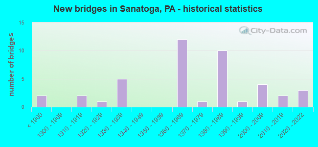
- New bridges - historical statistics
- 2Before 1900
- 21910-1919
- 11920-1929
- 51930-1939
- 121960-1969
- 11970-1979
- 101980-1989
- 11990-1999
- 42000-2009
- 22010-2019
- 32020-2022
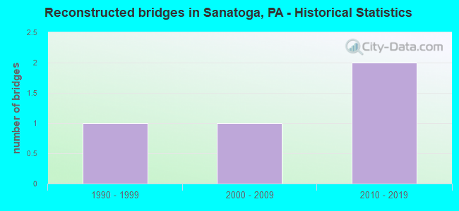
- Reconstructed bridges - Historical Statistics
- 11990-1999
- 12000-2009
- 22010-2019

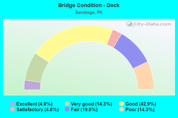
- Bridge Condition - Deck
- 4.8%Excellent
- 14.3%Very good
- 42.9%Good
- 4.8%Satisfactory
- 19.0%Fair
- 14.3%Poor
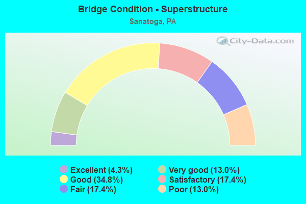
- Bridge Condition - Superstructure
- 4.3%Excellent
- 13.0%Very good
- 34.8%Good
- 17.4%Satisfactory
- 17.4%Fair
- 13.0%Poor
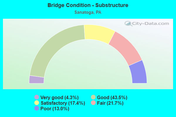
- Bridge Condition - Substructure
- 4.3%Very good
- 43.5%Good
- 17.4%Satisfactory
- 21.7%Fair
- 13.0%Poor
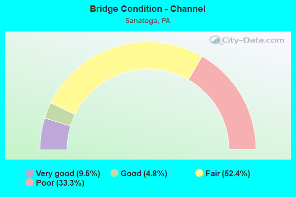
- Bridge Condition - Channel
- 9.5%Very good
- 4.8%Good
- 52.4%Fair
- 33.3%Poor
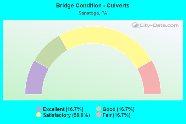
- Bridge Condition - Culverts
- 16.7%Excellent
- 16.7%Good
- 50.0%Satisfactory
- 16.7%Fair
Find on map >> Show street view
Structure Number: 10361, Location: PARKERFORD 7E5 (Lat: 40.205206, Lng: -75.580758), Route carried "on" structure: State highway , Year Built: 1932, Year Reconstructed: 2015, Status: Open, Structure Length: 11.43m (37.50ft), Average Daily Traffic: 5,291 (year 2021), Truck Traffic: 6%, Average Future Daily Traffic: 6,963 (year 2032), Design Load: HS 20, Features Intersected: SCHUYLKILL RIVER, Facility Carried by Structure: LINFIELD BRIDGE
Minimum Vertical Clearance: 30+ m (98+ ft), Kilometerpoint: 4.149, Lanes on structure: 2, Owner: State Highway Agency, Approaching Roadway Width: 11.0m (36.1ft), Material/Design: Steel, Design/Construction: Truss - Thru, Number Of Spans In Main Unit: 3, Length of Maximum Span: 37.5m (123.0ft), Curb or Sidewalk Widths: Left: 1.5m (4.9ft), Right: 0.0m, Curb-To-Curb Width: 6.8m (22.3ft), Out-to-Out Width: 7.9m (25.9ft)
Condition: Deck: Good, Superstructure: Satisfactory, Substructure: Satisfactory, Channel: Fair, Operating Rating: 69.9 metric tons, Method Used To Determine Operating Rating: Allowable Stress (AS), Inventory Rating: 33.6 metric tons, Method Used To Determine Inventory Rating: Allowable Stress (AS), Structural Evaluation: Equal to present minimum criteria, Deck Geometry: High priority of replacement, Waterway Adequacy: Superior to present desirable criteria, Approach Roadway Alignment: Meets minimum limits, Length Of Structure Improvement: 12.30m (40.35ft), Designated Inspection Frequency: Every 24 months, Critical Feature Inspection Frequency: Every 24 months, Underwater Inspection Frequency: Every 60 months, Inspection Date: December 2019, Critical Feature Inspection Date: December 2019, Underwater Inspection Date: April 2020, Bridge Improvement Cost: $69,000, Roadway Improvement Cost: $203,000, Total Project Cost: $930,000, Deck Structure Type: Concrete Cast-file-Place, Wearing Surface/Protective System: Wearing Surface: Monolithic Concrete, Deck Protection: Galvanized Reinforcing
Find on map >> Show street view
Structure Number: 10711, Location: E COVENTRY TWP 3139-F9 (Lat: 40.198161, Lng: -75.591544), Route carried "on" structure: City street , Year Built: 1916, Status: Posted for load, Structure Length: 1.07m (3.51ft), Average Daily Traffic: 244 (year 2017), Truck Traffic: 12%, Average Future Daily Traffic: 268 (year 2022), Features Intersected: PIGEON CREEK, Facility Carried by Structure: BAPTIST CHURCH RD
Minimum Vertical Clearance: 30+ m (98+ ft), Kilometerpoint: 0.000, Lanes on structure: 2, Owner: County Highway Agency, Approaching Roadway Width: 5.2m (17.1ft), Material/Design: Steel, Design/Construction: Stringer/Multi-beam, Number Of Spans In Main Unit: 1, Length of Maximum Span: 9.1m (29.9ft), Curb-To-Curb Width: 6.1m (20.0ft), Out-to-Out Width: 7.0m (23.0ft)
Condition: Deck: Fair, Superstructure: Fair, Substructure: Fair, Channel: Fair, Operating Rating: 65.3 metric tons, Method Used To Determine Operating Rating: Load Testing, Inventory Rating: 24.5 metric tons, Method Used To Determine Inventory Rating: Load Testing, Structural Evaluation: Somewhat better than minimum adequacy, Deck Geometry: Meets minimum limits, Waterway Adequacy: Equal to present minimum criteria, Approach Roadway Alignment: Equal to present minimum criteria, Length Of Structure Improvement: 1.80m (5.91ft), Designated Inspection Frequency: Every 24 months, Other Special Inspection Frequency: Every 12 months, Inspection Date: March 2021, Other Special Inspection Date: March 2021, Bridge Improvement Cost: $14,000, Roadway Improvement Cost: $40,000, Total Project Cost: $183,000, Deck Structure Type: Concrete Cast-file-Place, Wearing Surface/Protective System: Wearing Surface: Bituminous
Find on map >> Show street view
Structure Number: 10776, Location: 0.7 Mi SW PA-724 3139-D8 (Lat: 40.202775, Lng: -75.601978), Route carried "on" structure: City street , Year Built: 1973, Status: Open, Structure Length: 2.87m (9.42ft), Average Daily Traffic: 560 (year 2016), Truck Traffic: 2%, Average Future Daily Traffic: 800 (year 2036), Design Load: HS 20, Features Intersected: PIGEON CREEK, Facility Carried by Structure: SAYLOR'S MILL ROAD
Minimum Vertical Clearance: 30+ m (98+ ft), Kilometerpoint: 0.000, Lanes on structure: 2, Owner: Town or Township Highway Agency, Approaching Roadway Width: 7.3m (24.0ft), Material/Design: Steel, Design/Construction: Stringer/Multi-beam, Number Of Spans In Main Unit: 1, Length of Maximum Span: 27.4m (89.9ft), Curb or Sidewalk Widths: Left: 0.2m (0.7ft), Right: 0.2m (0.7ft), Curb-To-Curb Width: 13.4m (44.0ft), Out-to-Out Width: 14.6m (47.9ft)
Condition: Deck: Good, Superstructure: Good, Substructure: Good, Channel: Fair, Operating Rating: 90.7 metric tons, Method Used To Determine Operating Rating: Load Factor (LF), Inventory Rating: 54.4 metric tons, Method Used To Determine Inventory Rating: Load Factor (LF), Structural Evaluation: Better than present minimum criteria, Deck Geometry: Superior to present desirable criteria, Waterway Adequacy: Meets minimum limits, Approach Roadway Alignment: Equal to present desirable criteria, Length Of Structure Improvement: 3.50m (11.48ft), Designated Inspection Frequency: Every 24 months, Inspection Date: September 2020, Deck Structure Type: Concrete Cast-file-Place, Wearing Surface/Protective System: Wearing Surface: Monolithic Concrete, Deck Protection: Epoxy Coated Reinforcing
Find on map >> Show street view
Structure Number: 27415, Location: SANATOGA 12A12 (Lat: 40.239644, Lng: -75.609558), Route carried "on" structure: US 422, Year Built: 1966, Status: Open, Structure Length: 1.40m (4.59ft), Average Daily Traffic: 50,793 (year 2021), Truck Traffic: 4%, Average Future Daily Traffic: 65,079 (year 2032), Design Load: HS 20, Features Intersected: PORTER ROAD, Facility Carried by Structure: POTTSTOWN BY-PASS
Minimum Vertical Clearance: 30+ m (98+ ft), Kilometerpoint: 3.703, Lanes on structure: 2, Lanes under structure: 2, Base Highway Network: Yes, Owner: State Highway Agency, Approaching Roadway Width: 27.4m (89.9ft), Skew: 31 degrees, Material/Design: Prestressed concrete, Design/Construction: Stringer/Multi-beam, Number Of Spans In Main Unit: 1, Length of Maximum Span: 13.4m (44.0ft), Curb or Sidewalk Widths: Left: 0.5m (1.6ft), Right: 0.5m (1.6ft), Curb-To-Curb Width: 25.9m (85.0ft), Out-to-Out Width: 26.8m (87.9ft)
Condition: Deck: Satisfactory, Superstructure: Satisfactory, Substructure: Satisfactory, Operating Rating: 71.7 metric tons, Method Used To Determine Operating Rating: Load Factor (LF), Inventory Rating: 25.4 metric tons, Method Used To Determine Inventory Rating: Load Factor (LF), Structural Evaluation: Equal to present minimum criteria, Deck Geometry: Superior to present desirable criteria, Underclear: Meets minimum limits, Approach Roadway Alignment: Better than present minimum criteria, Length Of Structure Improvement: 2.00m (6.56ft), Designated Inspection Frequency: Every 24 months, Inspection Date: May 2021, Deck Structure Type: Concrete Cast-file-Place, Wearing Surface/Protective System: Wearing Surface: Bituminous
Find on map >> Show street view
Structure Number: 27416, Location: SANATOGA 12A12/3139C2 (Lat: 40.239781, Lng: -75.609319), Route carried "on" structure: US 422, Year Built: 1965, Status: Open, Structure Length: 1.28m (4.20ft), Average Daily Traffic: 50,793 (year 2021), Truck Traffic: 4%, Average Future Daily Traffic: 65,079 (year 2032), Design Load: HS 20, Features Intersected: SPROGLES RUN, Facility Carried by Structure: POTTSTOWN BY-PASS
Minimum Vertical Clearance: 30+ m (98+ ft), Kilometerpoint: 3.703, Lanes on structure: 4, Base Highway Network: Yes, Owner: State Highway Agency, Approaching Roadway Width: 25.9m (85.0ft), Skew: 21 degrees, Material/Design: Concrete, Design/Construction: Culvert, Number Of Spans In Main Unit: 2, Length of Maximum Span: 6.1m (20.0ft)
Condition: Channel: Fair, Culverts: Satisfactory, Operating Rating: 41.7 metric tons, Method Used To Determine Operating Rating: Load Factor (LF), Inventory Rating: 25.4 metric tons, Method Used To Determine Inventory Rating: Load Factor (LF), Structural Evaluation: Equal to present minimum criteria, Waterway Adequacy: Superior to present desirable criteria, Approach Roadway Alignment: Equal to present desirable criteria, Length Of Structure Improvement: 1.90m (6.23ft), Designated Inspection Frequency: Every 24 months, Inspection Date: August 2021
Find on map >> Show street view
Structure Number: 27417, Location: SANATOGA 12D11/3139G2 (Lat: 40.242842, Lng: -75.585828), Route carried "on" structure: US 422, Year Built: 1965, Status: Open, Structure Length: 10.15m (33.30ft), Average Daily Traffic: 50,793 (year 2021), Truck Traffic: 4%, Average Future Daily Traffic: 65,079 (year 2032), Design Load: HS 20, Features Intersected: SANATOGA RD, SANATOGA CR, Facility Carried by Structure: POTTSTOWN EXPRSWAY
Minimum Vertical Clearance: 30+ m (98+ ft), Kilometerpoint: 5.758, Lanes on structure: 2, Lanes under structure: 2, Base Highway Network: Yes, Owner: State Highway Agency, Approaching Roadway Width: 22.6m (74.1ft), Skew: 30 degrees, Material/Design: Prestressed concrete, Design/Construction: Stringer/Multi-beam, Number Of Spans In Main Unit: 4, Length of Maximum Span: 27.4m (89.9ft), Curb or Sidewalk Widths: Left: 0.5m (1.6ft), Right: 0.5m (1.6ft), Curb-To-Curb Width: 19.5m (64.0ft), Out-to-Out Width: 21.3m (69.9ft)
Condition: Deck: Fair, Superstructure: Satisfactory, Substructure: Poor, Channel: Fair, Operating Rating: 57.2 metric tons, Method Used To Determine Operating Rating: Load Factor (LF), Inventory Rating: 22.7 metric tons, Method Used To Determine Inventory Rating: Load Factor (LF), Structural Evaluation: Meets minimum limits, Deck Geometry: Superior to present desirable criteria, Underclear: Meets minimum limits, Waterway Adequacy: Superior to present desirable criteria, Approach Roadway Alignment: Equal to present desirable criteria, Length Of Structure Improvement: 11.10m (36.42ft), Designated Inspection Frequency: Every 24 months, Inspection Date: April 2021, Bridge Improvement Cost: $218,000, Roadway Improvement Cost: $643,000, Total Project Cost: $2,946,000, Deck Structure Type: Concrete Cast-file-Place, Wearing Surface/Protective System: Wearing Surface: Bituminous
Find on map >> Show street view
Structure Number: 27418, Location: LOWER POTTSGROVE 12E11 (Lat: 40.242472, Lng: -75.582853), Route carried "on" structure: State highway , Year Built: 1965, Status: Open, Structure Length: 2.71m (8.89ft), Average Daily Traffic: 171 (year 2016), Truck Traffic: 8%, Average Future Daily Traffic: 270 (year 2032), Design Load: HS 20, Features Intersected: POTTSTOWN BYPASS/3139-G2, Facility Carried by Structure: SOUTH PARK ROAD
Minimum Vertical Clearance: 30+ m (98+ ft), Kilometerpoint: 0.000, Lanes on structure: 2, Lanes under structure: 4, Owner: State Highway Agency, Approaching Roadway Width: 9.4m (30.8ft), Skew: 1 degrees, Material/Design: Prestressed concrete, Design/Construction: Stringer/Multi-beam, Number Of Spans In Main Unit: 1, Length of Maximum Span: 25.6m (84.0ft), Curb or Sidewalk Widths: Left: 0.5m (1.6ft), Right: 0.5m (1.6ft), Curb-To-Curb Width: 9.3m (30.5ft), Out-to-Out Width: 10.8m (35.4ft)
Condition: Deck: Good, Superstructure: Fair, Substructure: Satisfactory, Operating Rating: 89.8 metric tons, Method Used To Determine Operating Rating: Load Factor (LF), Inventory Rating: 21.8 metric tons, Method Used To Determine Inventory Rating: Load Factor (LF), Structural Evaluation: Somewhat better than minimum adequacy, Deck Geometry: Equal to present minimum criteria, Underclear: High priority of corrective action, Approach Roadway Alignment: Meets minimum limits, Length Of Structure Improvement: 3.30m (10.83ft), Designated Inspection Frequency: Every 24 months, Inspection Date: May 2021, Bridge Improvement Cost: $16,000, Roadway Improvement Cost: $47,000, Total Project Cost: $216,000, Deck Structure Type: Concrete Cast-file-Place, Wearing Surface/Protective System: Wearing Surface: Monolithic Concrete
Find on map >> Show street view
Structure Number: 27419, Location: LIMERICK TOWNSHIP 12J13 (Lat: 40.231217, Lng: -75.556319), Route carried "on" structure: State highway , Year Built: 1984, Status: Open, Structure Length: 7.56m (24.80ft), Average Daily Traffic: 2,569 (year 2021), Truck Traffic: 7%, Average Future Daily Traffic: 2,897 (year 2032), Design Load: HS 20, Features Intersected: POTTSTOWN EXPRESSWAY, Facility Carried by Structure: AIRPORT ROAD
Minimum Vertical Clearance: 30+ m (98+ ft), Kilometerpoint: 0.000, Lanes on structure: 2, Lanes under structure: 4, Owner: State Highway Agency, Approaching Roadway Width: 13.4m (44.0ft), Material/Design: Steel continuous, Design/Construction: Frame, Number Of Spans In Main Unit: 4, Length of Maximum Span: 23.2m (76.1ft), Curb or Sidewalk Widths: Left: 0.2m (0.7ft), Right: 0.2m (0.7ft), Curb-To-Curb Width: 12.8m (42.0ft), Out-to-Out Width: 13.9m (45.6ft)
Condition: Deck: Good, Superstructure: Good, Substructure: Good, Operating Rating: 67.1 metric tons, Method Used To Determine Operating Rating: Load Factor (LF), Inventory Rating: 39.9 metric tons, Method Used To Determine Inventory Rating: Load Factor (LF), Structural Evaluation: Better than present minimum criteria, Deck Geometry: Equal to present minimum criteria, Underclear: Meets minimum limits, Approach Roadway Alignment: Better than present minimum criteria, Length Of Structure Improvement: 8.40m (27.56ft), Designated Inspection Frequency: Every 24 months, Inspection Date: May 2021, Deck Structure Type: Concrete Cast-file-Place, Wearing Surface/Protective System: Wearing Surface: Monolithic Concrete, Deck Protection: Epoxy Coated Reinforcing
Find on map >> Show street view
Structure Number: 2742, Location: LIMERICK TWP 18K01/3140B4 (Lat: 40.226339, Lng: -75.550231), Route carried "on" structure: US 422, Year Built: 1984, Status: Open, Structure Length: 2.13m (6.99ft), Average Daily Traffic: 26,804 (year 2022), Truck Traffic: 9%, Average Future Daily Traffic: 32,897 (year 2032), Design Load: HS 20+Mod, Features Intersected: LIMERICK CENTER ROAD, Facility Carried by Structure: POTTSTOWN EWAY(EB)
Minimum Vertical Clearance: 30+ m (98+ ft), Kilometerpoint: 9.436, Lanes on structure: 2, Lanes under structure: 2, Base Highway Network: Yes, Owner: State Highway Agency, Approaching Roadway Width: 13.4m (44.0ft), Skew: 10 degrees, Material/Design: Prestressed concrete, Design/Construction: Stringer/Multi-beam, Number Of Spans In Main Unit: 1, Length of Maximum Span: 20.7m (67.9ft), Curb or Sidewalk Widths: Left: 0.2m (0.7ft), Right: 0.2m (0.7ft), Curb-To-Curb Width: 12.2m (40.0ft), Out-to-Out Width: 13.2m (43.3ft)
Condition: Deck: Good, Superstructure: Good, Substructure: Good, Operating Rating: 64.4 metric tons, Method Used To Determine Operating Rating: Load Factor (LF), Inventory Rating: 32.7 metric tons, Method Used To Determine Inventory Rating: Load Factor (LF), Structural Evaluation: Better than present minimum criteria, Deck Geometry: Better than present minimum criteria, Underclear: Equal to present minimum criteria, Approach Roadway Alignment: Equal to present desirable criteria, Length Of Structure Improvement: 2.90m (9.51ft), Designated Inspection Frequency: Every 24 months, Inspection Date: January 2021, Deck Structure Type: Concrete Cast-file-Place, Wearing Surface/Protective System: Wearing Surface: Monolithic Concrete, Deck Protection: Epoxy Coated Reinforcing
Find on map >> Show street view
Structure Number: 27421, Location: LIMERICK TWP 18K01/3140B4 (Lat: 40.226439, Lng: -75.550028), Route carried "on" structure: US 422, Year Built: 1984, Status: Open, Structure Length: 2.13m (6.99ft), Average Daily Traffic: 22,943 (year 2022), Truck Traffic: 12%, Average Future Daily Traffic: 33,383 (year 2032), Design Load: HS 20+Mod, Features Intersected: LIMERICK CENTER ROAD, Facility Carried by Structure: POTTSTOWN EXWY(WB)
Minimum Vertical Clearance: 30+ m (98+ ft), Kilometerpoint: 9.471, Lanes on structure: 2, Lanes under structure: 2, Base Highway Network: Yes, Owner: State Highway Agency, Approaching Roadway Width: 13.4m (44.0ft), Skew: 10 degrees, Material/Design: Prestressed concrete, Design/Construction: Stringer/Multi-beam, Number Of Spans In Main Unit: 1, Length of Maximum Span: 20.7m (67.9ft), Curb or Sidewalk Widths: Left: 0.2m (0.7ft), Right: 0.2m (0.7ft), Curb-To-Curb Width: 12.2m (40.0ft), Out-to-Out Width: 13.2m (43.3ft)
Condition: Deck: Good, Superstructure: Good, Substructure: Good, Operating Rating: 64.4 metric tons, Method Used To Determine Operating Rating: Load Factor (LF), Inventory Rating: 32.7 metric tons, Method Used To Determine Inventory Rating: Load Factor (LF), Structural Evaluation: Better than present minimum criteria, Deck Geometry: Better than present minimum criteria, Underclear: Meets minimum limits, Approach Roadway Alignment: Equal to present desirable criteria, Length Of Structure Improvement: 2.90m (9.51ft), Designated Inspection Frequency: Every 24 months, Inspection Date: January 2021, Deck Structure Type: Concrete Cast-file-Place, Wearing Surface/Protective System: Wearing Surface: Monolithic Concrete, Deck Protection: Epoxy Coated Reinforcing
Find on map >> Show street view
Structure Number: 27826, Location: U. FREDERICK 13A3/3028C5 (Lat: 40.286217, Lng: -75.543331), Route carried "on" structure: State highway , Year Built: 1854, Year Reconstructed: 2004, Status: Open, Structure Length: 1.83m (6.00ft), Average Daily Traffic: 1,378 (year 2020), Truck Traffic: 4%, Average Future Daily Traffic: 1,230 (year 2032), Design Load: H 15, Features Intersected: WEST SWAMP CREEK, Facility Carried by Structure: FAGLEYSVILLE ROAD
Minimum Vertical Clearance: 30+ m (98+ ft), Kilometerpoint: 0.008, Lanes on structure: 2, Owner: State Highway Agency, Approaching Roadway Width: 7.3m (24.0ft), Material/Design: Masonry, Design/Construction: Arch - Deck, Number Of Spans In Main Unit: 3, Length of Maximum Span: 6.1m (20.0ft), Curb or Sidewalk Widths: Left: 0.2m (0.7ft), Right: 0.2m (0.7ft), Curb-To-Curb Width: 6.0m (19.7ft), Out-to-Out Width: 7.3m (24.0ft)
Condition: Superstructure: Good, Substructure: Good, Channel: Poor, Operating Rating: 68.9 metric tons, Method Used To Determine Operating Rating: Field evaluation and documented engineering judgment, Inventory Rating: 34.5 metric tons, Method Used To Determine Inventory Rating: Field evaluation and documented engineering judgment, Structural Evaluation: Better than present minimum criteria, Deck Geometry: High priority of replacement, Waterway Adequacy: Equal to present minimum criteria, Approach Roadway Alignment: Equal to present desirable criteria, Length Of Structure Improvement: 2.30m (7.55ft), Designated Inspection Frequency: Every 24 months, Inspection Date: March 2020
Find on map >> Show street view
Structure Number: 27832, Location: SANATOGA 12E10/3139H1 (Lat: 40.249228, Lng: -75.580878), Route carried "on" structure: State highway , Year Built: 1961, Status: Open, Structure Length: 1.01m (3.31ft), Average Daily Traffic: 1,472 (year 2022), Truck Traffic: 4%, Average Future Daily Traffic: 1,485 (year 2032), Design Load: H 20, Features Intersected: SANATOGA CREEK, Facility Carried by Structure: SANATOGA ROAD
Minimum Vertical Clearance: 30+ m (98+ ft), Kilometerpoint: 0.000, Lanes on structure: 2, Owner: State Highway Agency, Approaching Roadway Width: 11.0m (36.1ft), Skew: 4 degrees, Material/Design: Prestressed concrete, Design/Construction: Box Beam or Girders - Single/Spread, Number Of Spans In Main Unit: 1, Length of Maximum Span: 9.1m (29.9ft), Curb or Sidewalk Widths: Left: 0.5m (1.6ft), Right: 0.5m (1.6ft), Curb-To-Curb Width: 11.0m (36.1ft), Out-to-Out Width: 12.2m (40.0ft)
Condition: Deck: Fair, Superstructure: Satisfactory, Substructure: Fair, Channel: Fair, Operating Rating: 54.4 metric tons, Method Used To Determine Operating Rating: Load Factor (LF), Inventory Rating: 32.7 metric tons, Method Used To Determine Inventory Rating: Load Factor (LF), Structural Evaluation: Somewhat better than minimum adequacy, Deck Geometry: Equal to present minimum criteria, Waterway Adequacy: Better than present minimum criteria, Approach Roadway Alignment: Better than present minimum criteria, Length Of Structure Improvement: 1.60m (5.25ft), Designated Inspection Frequency: Every 24 months, Inspection Date: March 2021, Deck Structure Type: Concrete Cast-file-Place, Wearing Surface/Protective System: Wearing Surface: Monolithic Concrete
Find on map >> Show street view
Structure Number: 27833, Location: SANATOGA 12C12 (Lat: 40.235942, Lng: -75.592586), Route carried "on" structure: State highway , Year Built: 1931, Status: Open, Structure Length: 1.52m (4.99ft), Average Daily Traffic: 1,405 (year 2022), Truck Traffic: 3%, Average Future Daily Traffic: 1,592 (year 2032), Design Load: H 15, Features Intersected: SANATOGA CREEK, Facility Carried by Structure: PLEASANT VIEW ROAD
Minimum Vertical Clearance: 30+ m (98+ ft), Kilometerpoint: 0.000, Lanes on structure: 2, Owner: State Highway Agency, Approaching Roadway Width: 6.7m (22.0ft), Material/Design: Steel, Design/Construction: Stringer/Multi-beam, Number Of Spans In Main Unit: 1, Length of Maximum Span: 14.9m (48.9ft), Curb-To-Curb Width: 6.7m (22.0ft), Out-to-Out Width: 7.9m (25.9ft)
Condition: Deck: Poor, Superstructure: Poor, Substructure: Poor, Channel: Poor, Operating Rating: 63.5 metric tons, Method Used To Determine Operating Rating: Load Factor (LF), Inventory Rating: 38.1 metric tons, Method Used To Determine Inventory Rating: Load Factor (LF), Structural Evaluation: Meets minimum limits, Deck Geometry: High priority of corrective action, Waterway Adequacy: Better than present minimum criteria, Approach Roadway Alignment: Meets minimum limits, Length Of Structure Improvement: 2.20m (7.22ft), Designated Inspection Frequency: Every 24 months, Inspection Date: May 2021, Bridge Improvement Cost: $15,000, Roadway Improvement Cost: $45,000, Total Project Cost: $205,000, Deck Structure Type: Concrete Cast-file-Place, Wearing Surface/Protective System: Wearing Surface: Bituminous
Find on map >> Show street view
Structure Number: 27839, Location: LAUGH. WATERS 12J2/3028A4 (Lat: 40.293333, Lng: -75.556944), Route carried "on" structure: State highway , Year Built: 1963, Year Reconstructed: 2011, Status: Open, Structure Length: 1.68m (5.51ft), Average Daily Traffic: 2,231 (year 2022), Truck Traffic: 4%, Average Future Daily Traffic: 3,329 (year 2032), Design Load: HL 93, Features Intersected: MINISTER CREEK, Facility Carried by Structure: NEW HANOVER SQUARE
Minimum Vertical Clearance: 30+ m (98+ ft), Kilometerpoint: 0.752, Lanes on structure: 2, Owner: State Highway Agency, Approaching Roadway Width: 9.1m (29.9ft), Material/Design: Prestressed concrete, Design/Construction: Box Beam or Girders - Multiple, Number Of Spans In Main Unit: 1, Length of Maximum Span: 15.8m (51.8ft), Curb-To-Curb Width: 9.1m (29.9ft), Out-to-Out Width: 10.4m (34.1ft)
Condition: Deck: Very good, Superstructure: Very good, Substructure: Good, Channel: Fair, Operating Rating: 56.7 metric tons, Method Used To Determine Operating Rating: Assigned ratings based on Load and Resistance Factor Design (LRFD) reported by rating factor (RF) using HL93 loadings, Inventory Rating: 36.3 metric tons, Method Used To Determine Inventory Rating: Assigned ratings based on Load and Resistance Factor Design (LRFD) reported by rating factor (RF) using HL93 loadings, Structural Evaluation: Better than present minimum criteria, Deck Geometry: Meets minimum limits, Waterway Adequacy: Equal to present minimum criteria, Approach Roadway Alignment: Equal to present desirable criteria, Length Of Structure Improvement: 2.40m (7.87ft), Designated Inspection Frequency: Every 24 months, Inspection Date: November 2019, Deck Structure Type: Concrete Cast-file-Place, Wearing Surface/Protective System: Wearing Surface: Monolithic Concrete, Membrane: Other, Deck Protection: Epoxy Coated Reinforcing
Find on map >> Show street view
Structure Number: 27846, Location: SANATOGA 12E11/3139G1 (Lat: 40.244431, Lng: -75.585528), Route carried "on" structure: State highway , Year Built: 1914, Year Reconstructed: 2010, Status: Open, Structure Length: 1.40m (4.59ft), Average Daily Traffic: 15,375 (year 2021), Truck Traffic: 3%, Average Future Daily Traffic: 16,017 (year 2032), Design Load: H 15, Features Intersected: SANATOGA CREEK, Facility Carried by Structure: RIDGE PIKE
Minimum Vertical Clearance: 30+ m (98+ ft), Kilometerpoint: 20.278, Lanes on structure: 2, Base Highway Network: Yes, Owner: State Highway Agency, Approaching Roadway Width: 12.8m (42.0ft), Skew: 20 degrees, Material/Design: Masonry, Design/Construction: Arch - Deck, Number Of Spans In Main Unit: 2, Length of Maximum Span: 6.4m (21.0ft), Curb-To-Curb Width: 11.1m (36.4ft), Out-to-Out Width: 12.5m (41.0ft)
Condition: Deck: Very good, Superstructure: Good, Substructure: Good, Channel: Poor, Operating Rating: 83.5 metric tons, Method Used To Determine Operating Rating: Field evaluation and documented engineering judgment, Inventory Rating: 49.9 metric tons, Method Used To Determine Inventory Rating: Field evaluation and documented engineering judgment, Structural Evaluation: Better than present minimum criteria, Deck Geometry: Meets minimum limits, Waterway Adequacy: Equal to present minimum criteria, Approach Roadway Alignment: Equal to present desirable criteria, Length Of Structure Improvement: 2.20m (7.22ft), Designated Inspection Frequency: Every 24 months, Inspection Date: March 2021, Bridge Improvement Cost: $72,000, Roadway Improvement Cost: $211,000, Total Project Cost: $969,000, Deck Structure Type: Concrete Cast-file-Place
Find on map >> Show street view
Structure Number: 27908, Location: 0.4 Mi N Ridge Pk 3140-C1 (Lat: 40.247675, Lng: -75.548456), Route carried "on" structure: City street 422, Year Built: 1858, Status: Open, Structure Length: 0.91m (2.99ft), Average Daily Traffic: 1,860 (year 2019), Truck Traffic: 34%, Average Future Daily Traffic: 1,586 (year 2018), Features Intersected: HARTENSTINE CREEK, Facility Carried by Structure: FRUITVILLE ROAD
Minimum Vertical Clearance: 30+ m (98+ ft), Kilometerpoint: 0.000, Lanes on structure: 2, Owner: County Highway Agency, Approaching Roadway Width: 5.2m (17.1ft), Skew: 3 degrees, Material/Design: Masonry, Design/Construction: Arch - Deck, Number Of Spans In Main Unit: 1, Length of Maximum Span: 9.1m (29.9ft), Curb-To-Curb Width: 5.9m (19.4ft), Out-to-Out Width: 7.0m (23.0ft)
Condition: Superstructure: Fair, Substructure: Fair, Channel: Good, Operating Rating: 55.3 metric tons, Method Used To Determine Operating Rating: Field evaluation and documented engineering judgment, Inventory Rating: 32.7 metric tons, Method Used To Determine Inventory Rating: Field evaluation and documented engineering judgment, Structural Evaluation: Somewhat better than minimum adequacy, Deck Geometry: High priority of replacement, Waterway Adequacy: Equal to present desirable criteria, Approach Roadway Alignment: Equal to present desirable criteria, Length Of Structure Improvement: 1.10m (3.61ft), Designated Inspection Frequency: Every 24 months, Inspection Date: April 2020, Bridge Improvement Cost: $6,000, Roadway Improvement Cost: $18,000, Total Project Cost: $82,000
Find on map >> Show street view
Structure Number: 27973, Location: 0.35 MI N OF SR 4021 (Lat: 40.252297, Lng: -75.535200), Route carried "on" structure: City street , Year Built: 1931, Status: Open, Structure Length: 0.79m (2.59ft), Average Daily Traffic: 13,785 (year 2019), Average Future Daily Traffic: 11,918 (year 2018), Features Intersected: HARTENSTINE CREEK, Facility Carried by Structure: SWAMP PIKE
Minimum Vertical Clearance: 30+ m (98+ ft), Kilometerpoint: 0.000, Lanes on structure: 2, Base Highway Network: Yes, Owner: County Highway Agency, Approaching Roadway Width: 7.6m (24.9ft), Skew: 3 degrees, Material/Design: Concrete, Design/Construction: Slab, Number Of Spans In Main Unit: 1, Length of Maximum Span: 6.1m (20.0ft), Curb-To-Curb Width: 11.8m (38.7ft), Out-to-Out Width: 12.5m (41.0ft)
Condition: Deck: Fair, Superstructure: Fair, Substructure: Fair, Channel: Poor, Operating Rating: 52.6 metric tons, Method Used To Determine Operating Rating: Load Factor (LF), Inventory Rating: 31.8 metric tons, Method Used To Determine Inventory Rating: Load Factor (LF), Structural Evaluation: Somewhat better than minimum adequacy, Deck Geometry: Somewhat better than minimum adequacy, Waterway Adequacy: Better than present minimum criteria, Approach Roadway Alignment: Equal to present desirable criteria, Length Of Structure Improvement: 1.00m (3.28ft), Designated Inspection Frequency: Every 24 months, Inspection Date: August 2020, Bridge Improvement Cost: $18,000, Roadway Improvement Cost: $53,000, Total Project Cost: $244,000, Wearing Surface/Protective System: Wearing Surface: Bituminous
Find on map >> Show street view
Structure Number: 28029, Location: .4 MI S OF E HIGH 3139-C2 (Lat: 40.238644, Lng: -75.608731), Route carried "on" structure: City street , Year Built: 2001, Status: Open, Structure Length: 0.76m (2.49ft), Average Daily Traffic: 500 (year 2020), Truck Traffic: 1%, Average Future Daily Traffic: 650 (year 2040), Design Load: HS 20, Features Intersected: SPROGELS RUN, Facility Carried by Structure: SANATOGA STA RD
Minimum Vertical Clearance: 30+ m (98+ ft), Kilometerpoint: 0.000, Lanes on structure: 2, Owner: Town or Township Highway Agency, Approaching Roadway Width: 7.3m (24.0ft), Skew: 2 degrees, Material/Design: Prestressed concrete, Design/Construction: Box Beam or Girders - Multiple, Number Of Spans In Main Unit: 1, Length of Maximum Span: 7.3m (24.0ft), Curb or Sidewalk Widths: Left: 1.2m (3.9ft), Right: 0.2m (0.7ft), Curb-To-Curb Width: 7.3m (24.0ft), Out-to-Out Width: 10.1m (33.1ft)
Condition: Deck: Good, Superstructure: Very good, Substructure: Satisfactory, Channel: Poor, Inventory Rating: 99.8 metric tons, Method Used To Determine Inventory Rating: Load Factor (LF), Structural Evaluation: Equal to present minimum criteria, Deck Geometry: Meets minimum limits, Waterway Adequacy: Equal to present desirable criteria, Approach Roadway Alignment: Somewhat better than minimum adequacy, Length Of Structure Improvement: 3.90m (12.80ft), Designated Inspection Frequency: Every 24 months, Inspection Date: April 2020, Bridge Improvement Cost: $1,000, Roadway Improvement Cost: $3,000, Total Project Cost: $15,000, Deck Structure Type: Concrete Cast-file-Place, Wearing Surface/Protective System: Wearing Surface: Monolithic Concrete, Deck Protection: Epoxy Coated Reinforcing
Find on map >> Show street view
Structure Number: 28065, Location: LONGVIEW ROAD 3139-H7 (Lat: 40.206497, Lng: -75.577797), Route carried "on" structure: City street , Year Built: 1989, Status: Open, Structure Length: 1.77m (5.81ft), Average Daily Traffic: 900 (year 2018), Truck Traffic: 1%, Average Future Daily Traffic: 1,100 (year 2038), Design Load: HS 20, Features Intersected: NS RAILROAD, Facility Carried by Structure: LONGVIEW ROAD
Minimum Vertical Clearance: 30+ m (98+ ft), Kilometerpoint: 0.000, Lanes on structure: 2, Owner: Town or Township Highway Agency, Approaching Roadway Width: 7.9m (25.9ft), Skew: 2 degrees, Material/Design: Prestressed concrete, Design/Construction: Box Beam or Girders - Multiple, Number Of Spans In Main Unit: 1, Length of Maximum Span: 17.1m (56.1ft), Curb or Sidewalk Widths: Left: 0.2m (0.7ft), Right: 0.2m (0.7ft), Curb-To-Curb Width: 7.5m (24.6ft), Out-to-Out Width: 8.6m (28.2ft)
Condition: Deck: Good, Superstructure: Good, Substructure: Good, Operating Rating: 96.2 metric tons, Method Used To Determine Operating Rating: Load Factor (LF), Inventory Rating: 57.2 metric tons, Method Used To Determine Inventory Rating: Load Factor (LF), Structural Evaluation: Better than present minimum criteria, Deck Geometry: Meets minimum limits, Underclear: High priority of corrective action, Approach Roadway Alignment: Equal to present desirable criteria, Length Of Structure Improvement: 2.40m (7.87ft), Designated Inspection Frequency: Every 24 months, Inspection Date: October 2020, Deck Structure Type: Concrete Cast-file-Place, Wearing Surface/Protective System: Wearing Surface: Monolithic Concrete, Deck Protection: Epoxy Coated Reinforcing
Find on map >> Show street view
Structure Number: 28066, Location: 2 MI W SR4013 ADC 3139-J5 (Lat: 40.222692, Lng: -75.574075), Route carried "on" structure: City street , Year Built: 1930, Status: Open, Structure Length: 0.61m (2.00ft), Average Daily Traffic: 300 (year 2016), Truck Traffic: 3%, Average Future Daily Traffic: 350 (year 2036), Design Load: HS 20, Features Intersected: BROOKE EVANS CREEK, Facility Carried by Structure: KEEN ROAD
Minimum Vertical Clearance: 30+ m (98+ ft), Kilometerpoint: 0.000, Lanes on structure: 2, Owner: Town or Township Highway Agency, Approaching Roadway Width: 5.8m (19.0ft), Material/Design: Concrete, Design/Construction: Culvert, Number Of Spans In Main Unit: 1, Length of Maximum Span: 6.1m (20.0ft)
Condition: Channel: Fair, Culverts: Satisfactory, Operating Rating: 49.0 metric tons, Method Used To Determine Operating Rating: Field evaluation and documented engineering judgment, Inventory Rating: 32.7 metric tons, Method Used To Determine Inventory Rating: Field evaluation and documented engineering judgment, Structural Evaluation: Equal to present minimum criteria, Waterway Adequacy: Superior to present desirable criteria, Approach Roadway Alignment: Equal to present desirable criteria, Length Of Structure Improvement: 1.00m (3.28ft), Designated Inspection Frequency: Every 24 months, Inspection Date: July 2020
Find on map >> Show street view
Structure Number: 43231, Location: FAGLEYSVILLE 12H4/3028A6 (Lat: 40.279575, Lng: -75.558753), Route carried "on" structure: State highway , Year Built: 2005, Status: Open, Structure Length: 0.76m (2.49ft), Average Daily Traffic: 1,378 (year 2020), Truck Traffic: 4%, Average Future Daily Traffic: 1,425 (year 2032), Design Load: HL 93, Features Intersected: BRANCH SWAMP CREEK, Facility Carried by Structure: FAGLEYSVILLE ROAD
Minimum Vertical Clearance: 30+ m (98+ ft), Kilometerpoint: 0.000, Lanes on structure: 2, Owner: State Highway Agency, Approaching Roadway Width: 8.2m (26.9ft), Material/Design: Concrete, Design/Construction: Culvert, Number Of Spans In Main Unit: 1, Length of Maximum Span: 7.0m (23.0ft), Curb-To-Curb Width: 8.5m (27.9ft), Out-to-Out Width: 9.1m (29.9ft)
Condition: Channel: Fair, Culverts: Good, Operating Rating: 75.3 metric tons, Method Used To Determine Operating Rating: Load Factor (LF), Inventory Rating: 45.4 metric tons, Method Used To Determine Inventory Rating: Load Factor (LF), Structural Evaluation: Better than present minimum criteria, Deck Geometry: Somewhat better than minimum adequacy, Waterway Adequacy: Better than present minimum criteria, Approach Roadway Alignment: Equal to present desirable criteria, Designated Inspection Frequency: Every 24 months, Inspection Date: December 2019, Deck Structure Type: Concrete Cast-file-Place, Wearing Surface/Protective System: Wearing Surface: Monolithic Concrete, Deck Protection: Epoxy Coated Reinforcing
Find on map >> Show street view
Structure Number: 45697, Location: 1 MI S of PA-73 3028-C4 (Lat: 40.290700, Lng: -75.544397), Route carried "on" structure: County highway , Year Built: 2009, Status: Open, Structure Length: 2.38m (7.81ft), Average Daily Traffic: 612 (year 2019), Truck Traffic: 9%, Average Future Daily Traffic: 219 (year 2018), Design Load: HL 93, Features Intersected: Swamp Creek, Facility Carried by Structure: Colonial Road
Minimum Vertical Clearance: 30+ m (98+ ft), Kilometerpoint: 0.000, Lanes on structure: 2, Owner: County Highway Agency, Approaching Roadway Width: 9.8m (32.2ft), Material/Design: Prestressed concrete, Design/Construction: Box Beam or Girders - Multiple, Number Of Spans In Main Unit: 1, Length of Maximum Span: 23.8m (78.1ft), Curb-To-Curb Width: 9.8m (32.2ft), Out-to-Out Width: 11.1m (36.4ft)
Condition: Deck: Good, Superstructure: Good, Substructure: Good, Channel: Very good, Operating Rating: 68.0 metric tons, Method Used To Determine Operating Rating: Load and Resistance Factor (LRFR), Inventory Rating: 52.6 metric tons, Method Used To Determine Inventory Rating: Load and Resistance Factor (LRFR), Structural Evaluation: Better than present minimum criteria, Deck Geometry: Equal to present minimum criteria, Waterway Adequacy: Equal to present minimum criteria, Approach Roadway Alignment: Equal to present desirable criteria, Designated Inspection Frequency: Every 24 months, Inspection Date: March 2020, Deck Structure Type: Concrete Cast-file-Place, Wearing Surface/Protective System: Wearing Surface: Monolithic Concrete, Deck Protection: Epoxy Coated Reinforcing
Find on map >> Show street view
Structure Number: 54208, Location: N of Kolb Rd 3139E09 (Lat: 40.198997, Lng: -75.596800), Route carried "on" structure: City street , Year Built: 1990, Status: Open, Structure Length: 0.61m (2.00ft), Average Daily Traffic: 150 (year 2018), Average Future Daily Traffic: 183 (year 2038), Features Intersected: PIGEON CREEK, Facility Carried by Structure: ZEIBER ROAD
Minimum Vertical Clearance: 30+ m (98+ ft), Kilometerpoint: 0.000, Lanes on structure: 2, Owner: Town or Township Highway Agency, Approaching Roadway Width: 7.0m (23.0ft), Skew: 8 degrees, Material/Design: Concrete, Design/Construction: Culvert, Number Of Spans In Main Unit: 3, Length of Maximum Span: 2.1m (6.9ft), Curb-To-Curb Width: 7.0m (23.0ft), Out-to-Out Width: 7.6m (24.9ft)
Condition: Channel: Fair, Culverts: Satisfactory, Operating Rating: 75.3 metric tons, Method Used To Determine Operating Rating: Field evaluation and documented engineering judgment, Inventory Rating: 45.4 metric tons, Method Used To Determine Inventory Rating: Field evaluation and documented engineering judgment, Structural Evaluation: Equal to present minimum criteria, Deck Geometry: Meets minimum limits, Waterway Adequacy: Meets minimum limits, Approach Roadway Alignment: Equal to present desirable criteria, Designated Inspection Frequency: Every 24 months, Inspection Date: May 2021
Find on map >> Show street view
Structure Number: 55774, Location: 0.32 MI N OF SR 4031 (Lat: 40.248097, Lng: -75.572947), Route carried "on" structure: City street , Year Built: 2018, Status: Open, Structure Length: 0.85m (2.79ft), Average Daily Traffic: 3,387 (year 2019), Truck Traffic: 1%, Average Future Daily Traffic: 4,500 (year 2039), Design Load: HL 93, Features Intersected: HARTENSTINE CREEK, Facility Carried by Structure: RUPERT ROAD
Minimum Vertical Clearance: 30+ m (98+ ft), Kilometerpoint: 0.000, Lanes on structure: 2, Owner: Town or Township Highway Agency, Approaching Roadway Width: 8.5m (27.9ft), Material/Design: Concrete, Design/Construction: Culvert, Number Of Spans In Main Unit: 1, Length of Maximum Span: 7.9m (25.9ft), Curb or Sidewalk Widths: Left: 0.0m, Right: 1.2m (3.9ft), Curb-To-Curb Width: 8.5m (27.9ft), Out-to-Out Width: 10.7m (35.1ft)
Condition: Channel: Very good, Culverts: Excellent, Operating Rating: 42.1 metric tons, Method Used To Determine Operating Rating: Assigned ratings based on Load and Resistance Factor Design (LRFD) reported by rating factor (RF) using HL93 loadings, Inventory Rating: 35.6 metric tons, Method Used To Determine Inventory Rating: Assigned ratings based on Load and Resistance Factor Design (LRFD) reported by rating factor (RF) using HL93 loadings, Structural Evaluation: Superior to present desirable criteria, Deck Geometry: Meets minimum limits, Waterway Adequacy: Equal to present desirable criteria, Approach Roadway Alignment: Equal to present desirable criteria, Designated Inspection Frequency: Every 24 months, Inspection Date: December 2020
Find on map >> Show street view
Structure Number: 56751, Location: L POTTSGROVE 12A12/3139C2 (Lat: 40.237908, Lng: -75.611789), Route carried "on" structure: US 422, Year Built: 2019, Status: Open, Structure Length: 6.77m (22.21ft), Average Daily Traffic: 50,793 (year 2021), Truck Traffic: 4%, Average Future Daily Traffic: 65,079 (year 2032), Design Load: HL 93, Features Intersected: NORFOLK SOUTHERN, Facility Carried by Structure: POTTSTOWN BY-PASS
Minimum Vertical Clearance: 30+ m (98+ ft), Kilometerpoint: 2.990, Lanes on structure: 2, Base Highway Network: Yes, Owner: State Highway Agency, Approaching Roadway Width: 13.4m (44.0ft), Skew: 34 degrees, Material/Design: Prestressed concrete continuous, Design/Construction: Stringer/Multi-beam, Number Of Spans In Main Unit: 3, Length of Maximum Span: 34.1m (111.9ft), Curb-To-Curb Width: 13.4m (44.0ft), Out-to-Out Width: 29.0m (95.1ft)
Condition: Deck: Very good, Superstructure: Very good, Substructure: Good, Operating Rating: 56.4 metric tons, Method Used To Determine Operating Rating: Assigned ratings based on Load and Resistance Factor Design (LRFD) reported by rating factor (RF) using HL93 loadings, Inventory Rating: 37.6 metric tons, Method Used To Determine Inventory Rating: Assigned ratings based on Load and Resistance Factor Design (LRFD) reported by rating factor (RF) using HL93 loadings, Structural Evaluation: Better than present minimum criteria, Deck Geometry: Equal to present minimum criteria, Underclear: High priority of corrective action, Approach Roadway Alignment: Equal to present desirable criteria, Designated Inspection Frequency: Every 24 months, Inspection Date: May 2021, Deck Structure Type: Concrete Cast-file-Place, Wearing Surface/Protective System: Wearing Surface: Monolithic Concrete, Deck Protection: Epoxy Coated Reinforcing
Find on map >> Show street view
Structure Number: 57082, Location: 0.3 MI N RIDGE PIKE (Lat: 40.247500, Lng: -75.568056), Route carried "on" structure: City street , Year Built: 2003, Status: Open, Structure Length: 1.65m (5.41ft), Average Daily Traffic: 250 (year 2019), Truck Traffic: 5%, Average Future Daily Traffic: 350 (year 2039), Design Load: HS 20, Features Intersected: HARTENSTINE CREEK, Facility Carried by Structure: MASTERS DRIVE
Minimum Vertical Clearance: 30+ m (98+ ft), Kilometerpoint: 0.000, Lanes on structure: 2, Owner: Town or Township Highway Agency, Approaching Roadway Width: 9.8m (32.2ft), Material/Design: Concrete, Design/Construction: Culvert, Number Of Spans In Main Unit: 1, Length of Maximum Span: 15.8m (51.8ft)
Condition: Channel: Poor, Culverts: Fair, Operating Rating: 64.4 metric tons, Method Used To Determine Operating Rating: Field evaluation and documented engineering judgment, Inventory Rating: 38.1 metric tons, Method Used To Determine Inventory Rating: Field evaluation and documented engineering judgment, Structural Evaluation: Somewhat better than minimum adequacy, Waterway Adequacy: Superior to present desirable criteria, Approach Roadway Alignment: Equal to present desirable criteria, Designated Inspection Frequency: Every 24 months, Inspection Date: November 2019
Find on map >> Show street view
Structure Number: 57162, Location: E OF SANATOGA RD 2915-G9 (Lat: 40.254472, Lng: -75.578778), Route carried "on" structure: City street , Year Built: 1932, Status: Posted for load, Structure Length: 0.91m (2.99ft), Average Daily Traffic: 250 (year 2019), Truck Traffic: 5%, Average Future Daily Traffic: 350 (year 2040), Design Load: H 20, Features Intersected: SANATOGA CREEK, Facility Carried by Structure: SNELL ROAD
Minimum Vertical Clearance: 30+ m (98+ ft), Kilometerpoint: 0.000, Lanes on structure: 2, Owner: Town or Township Highway Agency, Approaching Roadway Width: 7.3m (24.0ft), Skew: 1 degrees, Material/Design: Steel, Design/Construction: Stringer/Multi-beam, Number Of Spans In Main Unit: 1, Length of Maximum Span: 8.2m (26.9ft), Curb-To-Curb Width: 7.3m (24.0ft), Out-to-Out Width: 8.4m (27.6ft)
Condition: Deck: Poor, Superstructure: Poor, Substructure: Fair, Channel: Fair, Operating Rating: 48.1 metric tons, Method Used To Determine Operating Rating: Load Factor (LF), Inventory Rating: 29.0 metric tons, Method Used To Determine Inventory Rating: Load Factor (LF), Structural Evaluation: Meets minimum limits, Deck Geometry: Somewhat better than minimum adequacy, Waterway Adequacy: Better than present minimum criteria, Approach Roadway Alignment: Equal to present minimum criteria, Designated Inspection Frequency: Every 24 months, Other Special Inspection Frequency: Every 12 months, Inspection Date: November 2019, Other Special Inspection Date: November 2020, Deck Structure Type: Concrete Cast-file-Place, Wearing Surface/Protective System: Wearing Surface: Bituminous
Find on map >> Show street view
Structure Number: 57163, Location: W OF SCHAFFER ROAD (Lat: 40.259611, Lng: -75.573111), Route carried "on" structure: City street , Year Built: 1926, Status: Open, Structure Length: 1.07m (3.51ft), Average Daily Traffic: 1,000 (year 2020), Average Future Daily Traffic: 1,200 (year 2040), Design Load: HS 20, Features Intersected: SANATOGA CREEK, Facility Carried by Structure: PRUSS HILL ROAD
Minimum Vertical Clearance: 30+ m (98+ ft), Kilometerpoint: 0.000, Lanes on structure: 2, Owner: Town or Township Highway Agency, Approaching Roadway Width: 5.5m (18.0ft), Material/Design: Concrete, Design/Construction: Slab, Number Of Spans In Main Unit: 2, Length of Maximum Span: 4.6m (15.1ft), Curb-To-Curb Width: 5.5m (18.0ft), Out-to-Out Width: 6.8m (22.3ft)
Condition: Deck: Poor, Superstructure: Poor, Substructure: Poor, Channel: Poor, Operating Rating: 43.5 metric tons, Method Used To Determine Operating Rating: Field evaluation and documented engineering judgment, Inventory Rating: 26.3 metric tons, Method Used To Determine Inventory Rating: Field evaluation and documented engineering judgment, Structural Evaluation: Meets minimum limits, Deck Geometry: High priority of replacement, Waterway Adequacy: Superior to present desirable criteria, Approach Roadway Alignment: Equal to present minimum criteria, Designated Inspection Frequency: Every 24 months, Inspection Date: January 2020, Deck Structure Type: Concrete Cast-file-Place, Wearing Surface/Protective System: Wearing Surface: Bituminous
Find on map >> Show street view
Structure Number: 68265, Location: SANATOGA 12C11 / 3139E02 (Lat: 40.241094, Lng: -75.596233), Route carried "on" structure: State highway , Year Built: 2021, Status: Open, Structure Length: 3.17m (10.40ft), Average Daily Traffic: 1,405 (year 2022), Truck Traffic: 3%, Average Future Daily Traffic: 1,592 (year 2032), Design Load: HL 93, Features Intersected: POTTSTOWN EXPRESSWAY, Facility Carried by Structure: S.PLEASANT VIEW RD
Minimum Vertical Clearance: 30+ m (98+ ft), Kilometerpoint: 0.000, Lanes on structure: 2, Lanes under structure: 4, Owner: State Highway Agency, Approaching Roadway Width: 11.0m (36.1ft), Material/Design: Prestressed concrete, Design/Construction: Stringer/Multi-beam, Number Of Spans In Main Unit: 1, Length of Maximum Span: 31.4m (103.0ft), Curb or Sidewalk Widths: Left: 0.2m (0.7ft), Right: 0.2m (0.7ft), Curb-To-Curb Width: 11.0m (36.1ft), Out-to-Out Width: 12.0m (39.4ft)
Condition: Deck: Excellent, Superstructure: Excellent, Substructure: Very good, Operating Rating: 58.0 metric tons, Method Used To Determine Operating Rating: Assigned ratings based on Load and Resistance Factor Design (LRFD) reported by rating factor (RF) using HL93 loadings, Inventory Rating: 45.0 metric tons, Method Used To Determine Inventory Rating: Assigned ratings based on Load and Resistance Factor Design (LRFD) reported by rating factor (RF) using HL93 loadings, Structural Evaluation: Equal to present desirable criteria, Deck Geometry: Equal to present minimum criteria, Underclear: Equal to present minimum criteria, Approach Roadway Alignment: Equal to present minimum criteria, Designated Inspection Frequency: Every 24 months, Inspection Date: September 2021, Deck Structure Type: Concrete Cast-file-Place, Wearing Surface/Protective System: Wearing Surface: Monolithic Concrete, Deck Protection: Epoxy Coated Reinforcing
Find on map >> Show street view
Structure Number: 27415, Location: SANATOGA 12A12 (Lat: 40.239644, Lng: -75.609558), Route carried "under" structure: City street , Year Built: 1966, Structure Length: 0. m, Average Daily Traffic: 9,000 (year 1980), Truck Traffic: 7%, Features Intersected: PORTER ROAD, Facility Carried by Structure: POTTSTOWN BY-PASS
Minimum Vertical Clearance: 4.65m (15.26ft), Kilometerpoint: 0.000, Lanes on structure: 2, Lanes under structure: 2, Material/Design: Prestressed concrete, Design/Construction: Stringer/Multi-beam, Length of Maximum Span: 13.4m (44.0ft)
Find on map >> Show street view
Structure Number: 27417, Location: SANATOGA 12D11/3139G2 (Lat: 40.242842, Lng: -75.585828), Route carried "under" structure: State highway , Year Built: 1965, Structure Length: 0. m, Average Daily Traffic: 1,050 (year 2010), Truck Traffic: 7%, Features Intersected: SANATOGA RD, SANATOGA CR, Facility Carried by Structure: POTTSTOWN EXPRSWAY
Minimum Vertical Clearance: 11.76m (38.58ft), Kilometerpoint: 0.000, Lanes on structure: 2, Lanes under structure: 2, Material/Design: Prestressed concrete, Design/Construction: Stringer/Multi-beam, Length of Maximum Span: 27.4m (89.9ft)
Find on map >> Show street view
Structure Number: 27418, Location: LOWER POTTSGROVE 12E11 (Lat: 40.242472, Lng: -75.582853), Route carried "under" structure: US 422, Year Built: 1965, Structure Length: 0. m, Average Daily Traffic: 25,393 (year 2021), Truck Traffic: 4%, Features Intersected: POTTSTOWN BYPASS/3139-G2, Facility Carried by Structure: SOUTH PARK ROAD
Minimum Vertical Clearance: 4.47m (14.67ft), Kilometerpoint: 5.758, Lanes on structure: 2, Lanes under structure: 2, Material/Design: Prestressed concrete, Design/Construction: Stringer/Multi-beam, Length of Maximum Span: 25.6m (84.0ft)
Find on map >> Show street view
Structure Number: 27418, Location: LOWER POTTSGROVE 12E11 (Lat: 40.242472, Lng: -75.582853), Route carried "under" structure: US 422, Year Built: 1965, Structure Length: 0. m, Average Daily Traffic: 25,400 (year 2021), Truck Traffic: 4%, Features Intersected: POTTSTOWN BYPASS/3139-G2, Facility Carried by Structure: SOUTH PARK ROAD
Minimum Vertical Clearance: 4.62m (15.16ft), Kilometerpoint: 5.773, Lanes on structure: 2, Lanes under structure: 2, Material/Design: Prestressed concrete, Design/Construction: Stringer/Multi-beam, Length of Maximum Span: 25.6m (84.0ft)
Find on map >> Show street view
Structure Number: 27419, Location: LIMERICK TOWNSHIP 12J13 (Lat: 40.231217, Lng: -75.556319), Route carried "under" structure: US 422, Year Built: 1984, Structure Length: 0. m, Average Daily Traffic: 26,804 (year 2022), Truck Traffic: 9%, Features Intersected: POTTSTOWN EXPRESSWAY, Facility Carried by Structure: AIRPORT ROAD
Minimum Vertical Clearance: 4.85m (15.91ft), Kilometerpoint: 8.690, Lanes on structure: 2, Lanes under structure: 2, Material/Design: Steel continuous, Design/Construction: Frame, Length of Maximum Span: 23.2m (76.1ft)
Find on map >> Show street view
Structure Number: 27419, Location: LIMERICK TOWNSHIP 12J13 (Lat: 40.231217, Lng: -75.556319), Route carried "under" structure: US 422, Year Built: 1984, Structure Length: 0. m, Average Daily Traffic: 22,943 (year 2022), Truck Traffic: 12%, Features Intersected: POTTSTOWN EXPRESSWAY, Facility Carried by Structure: AIRPORT ROAD
Minimum Vertical Clearance: 5.46m (17.91ft), Kilometerpoint: 8.711, Lanes on structure: 2, Lanes under structure: 2, Material/Design: Steel continuous, Design/Construction: Frame, Length of Maximum Span: 23.2m (76.1ft)
Find on map >> Show street view
Structure Number: 2742, Location: LIMERICK TWP 18K01/3140B4 (Lat: 40.226339, Lng: -75.550231), Route carried "under" structure: State highway , Year Built: 1984, Structure Length: 0. m, Average Daily Traffic: 2,149 (year 2020), Truck Traffic: 5%, Features Intersected: LIMERICK CENTER ROAD, Facility Carried by Structure: POTTSTOWN EWAY(EB)
Minimum Vertical Clearance: 4.65m (15.26ft), Kilometerpoint: 2.350, Lanes on structure: 2, Lanes under structure: 2, Material/Design: Prestressed concrete, Design/Construction: Stringer/Multi-beam, Length of Maximum Span: 20.7m (67.9ft)
Find on map >> Show street view
Structure Number: 27421, Location: LIMERICK TWP 18K01/3140B4 (Lat: 40.226439, Lng: -75.550028), Route carried "under" structure: State highway , Year Built: 1984, Structure Length: 0. m, Average Daily Traffic: 2,149 (year 2020), Truck Traffic: 5%, Features Intersected: LIMERICK CENTER ROAD, Facility Carried by Structure: POTTSTOWN EXWY(WB)
Minimum Vertical Clearance: 4.57m (14.99ft), Kilometerpoint: 2.350, Lanes on structure: 2, Lanes under structure: 2, Material/Design: Prestressed concrete, Design/Construction: Stringer/Multi-beam, Length of Maximum Span: 20.7m (67.9ft)
Find on map >> Show street view
Structure Number: 27831, Location: LOWER POTTSGROVE 12F11 (Lat: 40.241214, Lng: -75.575819), Route carried "under" structure: Alternate US 422, Year Built: 1984, Structure Length: 0. m, Average Daily Traffic: 25,393 (year 2021), Truck Traffic: 4%, Features Intersected: POTTSTOWN EXPWAY/3139-H2, Facility Carried by Structure: EVERGREEN ROAD
Minimum Vertical Clearance: 5.51m (18.08ft), Kilometerpoint: 6.687, Lanes on structure: 2, Lanes under structure: 2, Material/Design: Steel continuous, Design/Construction: Stringer/Multi-beam, Length of Maximum Span: 45.7m (149.9ft)
Find on map >> Show street view
Structure Number: 27831, Location: LOWER POTTSGROVE 12F11 (Lat: 40.241214, Lng: -75.575819), Route carried "under" structure: Alternate US 422, Year Built: 1984, Structure Length: 0. m, Average Daily Traffic: 22,943 (year 2022), Truck Traffic: 12%, Features Intersected: POTTSTOWN EXPWAY/3139-H2, Facility Carried by Structure: EVERGREEN ROAD
Minimum Vertical Clearance: 4.80m (15.75ft), Kilometerpoint: 6.713, Lanes on structure: 2, Lanes under structure: 2, Material/Design: Steel continuous, Design/Construction: Stringer/Multi-beam, Length of Maximum Span: 45.7m (149.9ft)
Find on map >> Show street view
Structure Number: 27845, Location: LIMERICK 12G11 (Lat: 40.243128, Lng: -75.570725), Route carried "under" structure: Bypass State highway , Year Built: 1965, Structure Length: 0. m, Average Daily Traffic: 4,508 (year 2022), Truck Traffic: 12%, Features Intersected: TOWNSHIP LINE ROAD, Facility Carried by Structure: RIDGE PIKE
Minimum Vertical Clearance: 4.62m (15.16ft), Kilometerpoint: 0.000, Lanes on structure: 2, Lanes under structure: 2, Material/Design: Steel, Design/Construction: Stringer/Multi-beam, Length of Maximum Span: 37.8m (124.0ft)
Find on map >> Show street view
Structure Number: 27845, Location: LIMERICK 12G11 (Lat: 40.243128, Lng: -75.570725), Route carried "under" structure: Bypass State highway , Year Built: 1965, Structure Length: 0. m, Average Daily Traffic: 3,734 (year 2022), Truck Traffic: 10%, Features Intersected: TOWNSHIP LINE ROAD, Facility Carried by Structure: RIDGE PIKE
Minimum Vertical Clearance: 4.47m (14.67ft), Kilometerpoint: 0.000, Lanes on structure: 2, Lanes under structure: 2, Material/Design: Steel, Design/Construction: Stringer/Multi-beam, Length of Maximum Span: 37.8m (124.0ft)
Find on map >> Show street view
Structure Number: 68265, Location: SANATOGA 12C11 / 3139E02 (Lat: 40.241094, Lng: -75.596233), Route carried "under" structure: US 422, Year Built: 2021, Structure Length: 0. m, Average Daily Traffic: 25,400 (year 2021), Truck Traffic: 4%, Features Intersected: POTTSTOWN EXPRESSWAY, Facility Carried by Structure: S.PLEASANT VIEW RD
Minimum Vertical Clearance: 5.28m (17.32ft), Kilometerpoint: 4.884, Lanes on structure: 2, Lanes under structure: 2, Material/Design: Prestressed concrete, Design/Construction: Stringer/Multi-beam, Length of Maximum Span: 31.4m (103.0ft)
Find on map >> Show street view
Structure Number: 68265, Location: SANATOGA 12C11 / 3139E02 (Lat: 40.241094, Lng: -75.596233), Route carried "under" structure: US 422, Year Built: 2021, Structure Length: 0. m, Average Daily Traffic: 25,393 (year 2021), Truck Traffic: 4%, Features Intersected: POTTSTOWN EXPRESSWAY, Facility Carried by Structure: S.PLEASANT VIEW RD
Minimum Vertical Clearance: 5.27m (17.29ft), Kilometerpoint: 4.875, Lanes on structure: 2, Lanes under structure: 2, Material/Design: Prestressed concrete, Design/Construction: Stringer/Multi-beam, Length of Maximum Span: 31.4m (103.0ft)