Bridge Statistics for Sand Springs, Texas (TX)
Condition, Traffic, Stress, Structural Evaluation, Project Costs
- National Bridge Inventory (NBI) Statistics
- 14Number of bridges
- 98ft / 29.8mTotal length
- $831,000Total costs
- 92,607Total average daily traffic
- 31,216Total average daily truck traffic
- National Bridge Inventory (NBI) Registered Bridges for Sand Springs
- No street view available for this location
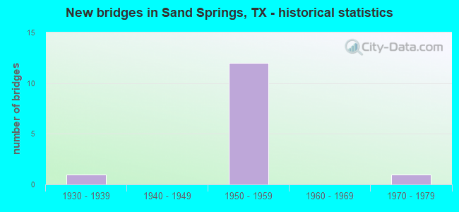
- New bridges - historical statistics
- 11930-1939
- 121950-1959
- 11970-1979


- Bridge Condition - Deck
- 42.9%Good
- 57.1%Satisfactory

- Bridge Condition - Superstructure
- 42.9%Good
- 57.1%Satisfactory

- Bridge Condition - Substructure
- 85.7%Good
- 14.3%Satisfactory

- Bridge Condition - Channel
- 50.0%Good
- 50.0%Satisfactory
Find on map >> Show street view
Structure Number: 81150000506021, Location: 2.3 MI W OF FM 820 (Lat: 32.284417, Lng: -101.341869), Route carried "on" structure: Interstate 20, Year Built: 1935, Year Reconstructed: 1956, Status: Open, Structure Length: 1.65m (5.41ft), Average Daily Traffic: 20,214 (year 2020), Truck Traffic: 34%, Average Future Daily Traffic: 36,120 (year 2035), Features Intersected: SANDY HOLLOW CREEK
Minimum Vertical Clearance: 30+ m (98+ ft), Kilometerpoint: 53.617, Lanes on structure: 8, Base Highway Network: Yes, Owner: State Highway Agency, Approaching Roadway Width: 36.6m (120.1ft), Skew: 20 degrees, Material/Design: Concrete, Design/Construction: Culvert, Number Of Spans In Main Unit: 5, Length of Maximum Span: 3.0m (9.8ft)
Condition: Channel: Good, Culverts: Satisfactory, Operating Rating: 32.7 metric tons, Method Used To Determine Operating Rating: Field evaluation and documented engineering judgment, Inventory Rating: 24.5 metric tons, Method Used To Determine Inventory Rating: Field evaluation and documented engineering judgment, Structural Evaluation: Equal to present minimum criteria, Waterway Adequacy: Equal to present minimum criteria, Approach Roadway Alignment: Equal to present desirable criteria, Length Of Structure Improvement: 1.65m (5.41ft), Designated Inspection Frequency: Every 24 months, Inspection Date: June 2021, Bridge Improvement Cost: $65,000, Roadway Improvement Cost: $17,000, Total Project Cost: $82,000
Find on map >> Show street view
Structure Number: 81150000506084, Location: 4.0 MI W OF FM 820 (Lat: 32.274786, Lng: -101.370511), Route carried "on" structure: Interstate 20, Year Built: 1959, Status: Open, Structure Length: 3.47m (11.38ft), Average Daily Traffic: 11,738 (year 2019), Truck Traffic: 34%, Average Future Daily Traffic: 18,060 (year 2035), Design Load: HS 20, Features Intersected: MOSS LAKE RD
Minimum Vertical Clearance: 30+ m (98+ ft), Kilometerpoint: 0.000, Lanes on structure: 2, Lanes under structure: 2, Base Highway Network: Yes, Owner: State Highway Agency, Approaching Roadway Width: 11.6m (38.1ft), Material/Design: Concrete continuous, Design/Construction: Slab, Number Of Spans In Main Unit: 3, Length of Maximum Span: 13.7m (44.9ft), Curb-To-Curb Width: 11.3m (37.1ft), Out-to-Out Width: 12.2m (40.0ft)
Condition: Deck: Satisfactory, Superstructure: Satisfactory, Substructure: Good, Operating Rating: 53.5 metric tons, Method Used To Determine Operating Rating: Load Factor (LF), Inventory Rating: 31.7 metric tons, Method Used To Determine Inventory Rating: Load Factor (LF), Structural Evaluation: Equal to present minimum criteria, Deck Geometry: Somewhat better than minimum adequacy, Underclear: Meets minimum limits, Approach Roadway Alignment: Equal to present desirable criteria, Designated Inspection Frequency: Every 24 months, Inspection Date: June 2021, Deck Structure Type: Concrete Cast-file-Place, Wearing Surface/Protective System: Wearing Surface: Bituminous
Find on map >> Show street view
Structure Number: 81150000506085, Location: 4.0 MI W OF FM 820 (Lat: 32.274611, Lng: -101.370461), Route carried "on" structure: Interstate 20, Year Built: 1959, Status: Open, Structure Length: 3.47m (11.38ft), Average Daily Traffic: 11,987 (year 2019), Truck Traffic: 34%, Average Future Daily Traffic: 18,060 (year 2035), Design Load: HS 20, Features Intersected: MOSS LAKE RD
Minimum Vertical Clearance: 30+ m (98+ ft), Kilometerpoint: 50.678, Lanes on structure: 2, Lanes under structure: 2, Base Highway Network: Yes, Owner: State Highway Agency, Approaching Roadway Width: 11.6m (38.1ft), Material/Design: Concrete continuous, Design/Construction: Slab, Number Of Spans In Main Unit: 3, Length of Maximum Span: 13.7m (44.9ft), Curb-To-Curb Width: 11.3m (37.1ft), Out-to-Out Width: 12.2m (40.0ft)
Condition: Deck: Satisfactory, Superstructure: Satisfactory, Substructure: Good, Operating Rating: 53.5 metric tons, Method Used To Determine Operating Rating: Load Factor (LF), Inventory Rating: 31.7 metric tons, Method Used To Determine Inventory Rating: Load Factor (LF), Structural Evaluation: Equal to present minimum criteria, Deck Geometry: Somewhat better than minimum adequacy, Underclear: Meets minimum limits, Approach Roadway Alignment: Equal to present desirable criteria, Designated Inspection Frequency: Every 24 months, Inspection Date: June 2021, Deck Structure Type: Concrete Cast-file-Place, Wearing Surface/Protective System: Wearing Surface: Bituminous
Find on map >> Show street view
Structure Number: 81150000506086, Location: 8.2 MI E OF US 87 (Lat: 32.281089, Lng: -101.354753), Route carried "on" structure: Interstate 20, Year Built: 1959, Status: Open, Structure Length: 3.47m (11.38ft), Average Daily Traffic: 11,738 (year 2019), Truck Traffic: 34%, Average Future Daily Traffic: 18,060 (year 2035), Design Load: HS 20, Features Intersected: SAND SPRINGS RD
Minimum Vertical Clearance: 30+ m (98+ ft), Kilometerpoint: 0.000, Lanes on structure: 2, Lanes under structure: 2, Base Highway Network: Yes, Owner: State Highway Agency, Approaching Roadway Width: 11.6m (38.1ft), Material/Design: Concrete continuous, Design/Construction: Slab, Number Of Spans In Main Unit: 3, Length of Maximum Span: 13.7m (44.9ft), Curb-To-Curb Width: 11.3m (37.1ft), Out-to-Out Width: 12.1m (39.7ft)
Condition: Deck: Satisfactory, Superstructure: Satisfactory, Substructure: Good, Operating Rating: 53.5 metric tons, Method Used To Determine Operating Rating: Load Factor (LF), Inventory Rating: 31.7 metric tons, Method Used To Determine Inventory Rating: Load Factor (LF), Structural Evaluation: Equal to present minimum criteria, Deck Geometry: Somewhat better than minimum adequacy, Underclear: High priority of corrective action, Approach Roadway Alignment: Equal to present desirable criteria, Designated Inspection Frequency: Every 24 months, Inspection Date: June 2021, Deck Structure Type: Concrete Cast-file-Place, Wearing Surface/Protective System: Wearing Surface: Bituminous
Find on map >> Show street view
Structure Number: 81150000506087, Location: 8.2 MI E OF US 87 (Lat: 32.280936, Lng: -101.354628), Route carried "on" structure: Interstate 20, Year Built: 1959, Status: Open, Structure Length: 3.47m (11.38ft), Average Daily Traffic: 11,987 (year 2019), Truck Traffic: 34%, Average Future Daily Traffic: 18,060 (year 2035), Design Load: HS 20, Features Intersected: SAND SPRINGS RD
Minimum Vertical Clearance: 30+ m (98+ ft), Kilometerpoint: 52.321, Lanes on structure: 2, Lanes under structure: 2, Base Highway Network: Yes, Owner: State Highway Agency, Approaching Roadway Width: 11.6m (38.1ft), Material/Design: Concrete continuous, Design/Construction: Slab, Number Of Spans In Main Unit: 3, Length of Maximum Span: 13.7m (44.9ft), Curb-To-Curb Width: 11.3m (37.1ft), Out-to-Out Width: 12.2m (40.0ft)
Condition: Deck: Good, Superstructure: Good, Substructure: Satisfactory, Operating Rating: 53.5 metric tons, Method Used To Determine Operating Rating: Load Factor (LF), Inventory Rating: 31.7 metric tons, Method Used To Determine Inventory Rating: Load Factor (LF), Structural Evaluation: Equal to present minimum criteria, Deck Geometry: Somewhat better than minimum adequacy, Underclear: High priority of corrective action, Approach Roadway Alignment: Equal to present desirable criteria, Designated Inspection Frequency: Every 24 months, Inspection Date: June 2021, Deck Structure Type: Concrete Cast-file-Place, Wearing Surface/Protective System: Wearing Surface: Bituminous
Find on map >> Show street view
Structure Number: 81150000506088, Location: 9.2 MI E OF US 87 (Lat: 32.285347, Lng: -101.338272), Route carried "on" structure: Interstate 20, Year Built: 1959, Status: Open, Structure Length: 3.47m (11.38ft), Average Daily Traffic: 11,738 (year 2019), Truck Traffic: 34%, Average Future Daily Traffic: 18,060 (year 2035), Design Load: HS 20, Features Intersected: SALEM RD
Minimum Vertical Clearance: 30+ m (98+ ft), Kilometerpoint: 53.945, Lanes on structure: 2, Lanes under structure: 2, Base Highway Network: Yes, Owner: State Highway Agency, Approaching Roadway Width: 11.6m (38.1ft), Material/Design: Concrete continuous, Design/Construction: Slab, Number Of Spans In Main Unit: 3, Length of Maximum Span: 13.7m (44.9ft), Curb-To-Curb Width: 11.3m (37.1ft), Out-to-Out Width: 12.2m (40.0ft)
Condition: Deck: Good, Superstructure: Good, Substructure: Good, Operating Rating: 53.5 metric tons, Method Used To Determine Operating Rating: Load Factor (LF), Inventory Rating: 31.7 metric tons, Method Used To Determine Inventory Rating: Load Factor (LF), Structural Evaluation: Better than present minimum criteria, Deck Geometry: Somewhat better than minimum adequacy, Underclear: High priority of corrective action, Approach Roadway Alignment: Equal to present desirable criteria, Designated Inspection Frequency: Every 24 months, Inspection Date: June 2021, Deck Structure Type: Concrete Cast-file-Place, Wearing Surface/Protective System: Wearing Surface: Bituminous
Find on map >> Show street view
Structure Number: 81150000506089, Location: 9.2 MI E OF US 87 (Lat: 32.285181, Lng: -101.338217), Route carried "on" structure: Interstate 20, Year Built: 1959, Status: Open, Structure Length: 3.47m (11.38ft), Average Daily Traffic: 11,987 (year 2019), Truck Traffic: 34%, Average Future Daily Traffic: 18,060 (year 2035), Design Load: HS 20, Features Intersected: SALEM RD
Minimum Vertical Clearance: 30+ m (98+ ft), Kilometerpoint: 53.945, Lanes on structure: 2, Lanes under structure: 2, Base Highway Network: Yes, Owner: State Highway Agency, Approaching Roadway Width: 11.6m (38.1ft), Material/Design: Concrete continuous, Design/Construction: Slab, Number Of Spans In Main Unit: 3, Length of Maximum Span: 13.7m (44.9ft), Curb-To-Curb Width: 11.4m (37.4ft), Out-to-Out Width: 12.2m (40.0ft)
Condition: Deck: Satisfactory, Superstructure: Satisfactory, Substructure: Good, Operating Rating: 53.5 metric tons, Method Used To Determine Operating Rating: Load Factor (LF), Inventory Rating: 40.8 metric tons, Method Used To Determine Inventory Rating: Load Factor (LF), Structural Evaluation: Equal to present minimum criteria, Deck Geometry: Somewhat better than minimum adequacy, Underclear: Meets minimum limits, Approach Roadway Alignment: Equal to present desirable criteria, Designated Inspection Frequency: Every 24 months, Inspection Date: June 2021, Deck Structure Type: Concrete Cast-file-Place, Wearing Surface/Protective System: Wearing Surface: Bituminous
Find on map >> Show street view
Structure Number: 81150AA0237001, Location: 1.9 MI S OF IH 20 (Lat: 32.248697, Lng: -101.362361), Route carried "on" structure: County highway , Year Built: 1977, Status: Open, Structure Length: 7.32m (24.02ft), Average Daily Traffic: 918 (year 2019), Truck Traffic: 15%, Average Future Daily Traffic: 280 (year 2027), Design Load: H 15, Features Intersected: BEALS CREEK, Facility Carried by Structure: S MOSS LAKE RD
Minimum Vertical Clearance: 30+ m (98+ ft), Kilometerpoint: 2.092, Lanes on structure: 2, Owner: County Highway Agency, Approaching Roadway Width: 6.1m (20.0ft), Material/Design: Concrete, Design/Construction: Stringer/Multi-beam, Number Of Spans In Main Unit: 6, Length of Maximum Span: 12.2m (40.0ft), Curb-To-Curb Width: 7.9m (25.9ft), Out-to-Out Width: 8.6m (28.2ft)
Condition: Deck: Good, Superstructure: Good, Substructure: Good, Channel: Satisfactory, Operating Rating: 44.4 metric tons, Method Used To Determine Operating Rating: Load Factor (LF), Inventory Rating: 32.7 metric tons, Method Used To Determine Inventory Rating: Load Factor (LF), Structural Evaluation: Better than present minimum criteria, Deck Geometry: Somewhat better than minimum adequacy, Waterway Adequacy: Better than present minimum criteria, Approach Roadway Alignment: Equal to present desirable criteria, Length Of Structure Improvement: 8.41m (27.59ft), Designated Inspection Frequency: Every 24 months, Inspection Date: March 2020, Bridge Improvement Cost: $610,000, Roadway Improvement Cost: $139,000, Total Project Cost: $749,000, Deck Structure Type: Concrete Cast-file-Place, Wearing Surface/Protective System: Wearing Surface: Bituminous
Find on map >> Show street view
Structure Number: 81150000506084, Location: 4.0 MI W OF FM 820 (Lat: 32.274786, Lng: -101.370511), Route carried "under" structure: City street , Year Built: 1959, Structure Length: 0. m, Average Daily Traffic: 50 (year 2015), Truck Traffic: 5%, Features Intersected: Moss Lake Rd, Facility Carried by Structure: IH 20 WB
Minimum Vertical Clearance: 4.32m (14.17ft), Kilometerpoint: 0.000, Lanes on structure: 2, Lanes under structure: 2, Material/Design: Concrete continuous, Design/Construction: Slab, Length of Maximum Span: 13.7m (44.9ft)
Find on map >> Show street view
Structure Number: 81150000506085, Location: 4.0 MI W OF FM 820 (Lat: 32.274611, Lng: -101.370461), Route carried "under" structure: City street , Year Built: 1959, Structure Length: 0. m, Average Daily Traffic: 50 (year 2015), Truck Traffic: 5%, Features Intersected: Moss Lake Rd, Facility Carried by Structure: IH 20 EB
Minimum Vertical Clearance: 4.47m (14.67ft), Kilometerpoint: 0.000, Lanes on structure: 2, Lanes under structure: 2, Material/Design: Concrete continuous, Design/Construction: Slab, Length of Maximum Span: 13.7m (44.9ft)
Find on map >> Show street view
Structure Number: 81150000506086, Location: 8.2 MI E OF US 87 (Lat: 32.281089, Lng: -101.354753), Route carried "under" structure: City street , Year Built: 1959, Structure Length: 0. m, Average Daily Traffic: 50 (year 2015), Truck Traffic: 5%, Features Intersected: Sand Springs Rd, Facility Carried by Structure: IH 20 WB
Minimum Vertical Clearance: 4.12m (13.52ft), Kilometerpoint: 0.000, Lanes on structure: 2, Lanes under structure: 2, Material/Design: Concrete continuous, Design/Construction: Slab, Length of Maximum Span: 13.7m (44.9ft)
Find on map >> Show street view
Structure Number: 81150000506087, Location: 8.2 MI E OF US 87 (Lat: 32.280936, Lng: -101.354628), Route carried "under" structure: City street , Year Built: 1959, Structure Length: 0. m, Average Daily Traffic: 50 (year 2015), Truck Traffic: 5%, Features Intersected: Sand Springs Rd, Facility Carried by Structure: IH 20 EB
Minimum Vertical Clearance: 4.19m (13.75ft), Kilometerpoint: 0.000, Lanes on structure: 2, Lanes under structure: 2, Material/Design: Concrete continuous, Design/Construction: Slab, Length of Maximum Span: 13.7m (44.9ft)
Find on map >> Show street view
Structure Number: 81150000506088, Location: 9.2 MI E OF US 87 (Lat: 32.285347, Lng: -101.338272), Route carried "under" structure: City street , Year Built: 1959, Structure Length: 0. m, Average Daily Traffic: 50 (year 2015), Truck Traffic: 5%, Features Intersected: Salem Rd, Facility Carried by Structure: IH 20 WB
Minimum Vertical Clearance: 4.24m (13.91ft), Kilometerpoint: 0.000, Lanes on structure: 2, Lanes under structure: 2, Material/Design: Concrete continuous, Design/Construction: Slab, Length of Maximum Span: 13.7m (44.9ft)
Find on map >> Show street view
Structure Number: 81150000506089, Location: 9.2 MI E OF US 87 (Lat: 32.285181, Lng: -101.338217), Route carried "under" structure: City street , Year Built: 1959, Structure Length: 0. m, Average Daily Traffic: 50 (year 2015), Truck Traffic: 5%, Features Intersected: Salem Rd, Facility Carried by Structure: IH 20 EB
Minimum Vertical Clearance: 4.27m (14.01ft), Kilometerpoint: 0.000, Lanes on structure: 2, Lanes under structure: 2, Material/Design: Concrete continuous, Design/Construction: Slab, Length of Maximum Span: 13.7m (44.9ft)