Bridge Statistics for Sandy Creek, New York (NY)
Condition, Traffic, Stress, Structural Evaluation, Project Costs
- National Bridge Inventory (NBI) Statistics
- 13Number of bridges
- 102ft / 31.1mTotal length
- $16,460,000Total costs
- 71,402Total average daily traffic
- 3,816Total average daily truck traffic
- National Bridge Inventory (NBI) Registered Bridges for Sandy Creek
- No street view available for this location
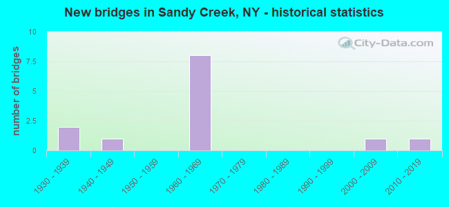
- New bridges - historical statistics
- 21930-1939
- 11940-1949
- 81960-1969
- 12000-2009
- 12010-2019


- Bridge Condition - Deck
- 11.1%Excellent
- 11.1%Very good
- 22.2%Good
- 44.4%Fair
- 11.1%Serious

- Bridge Condition - Superstructure
- 10.0%Excellent
- 10.0%Very good
- 10.0%Good
- 30.0%Satisfactory
- 40.0%Fair

- Bridge Condition - Substructure
- 10.0%Excellent
- 10.0%Very good
- 10.0%Good
- 40.0%Satisfactory
- 30.0%Fair

- Bridge Condition - Channel
- 28.6%Good
- 14.3%Satisfactory
- 28.6%Fair
- 28.6%Poor
Find on map >> Show street view
Structure Number: 100041, Location: 2.3MI SE JEFFERSON CL + 3 (Lat: 43.653347, Lng: -76.149453), Route carried "on" structure: State highway 3, Year Built: 2002, Status: Open, Structure Length: 0.94m (3.08ft), Average Daily Traffic: 1,279 (year 2018), Truck Traffic: 9%, Average Future Daily Traffic: 1,286 (year 2040), Design Load: HS 25 or greater, Features Intersected: BLIND CREEK
Minimum Vertical Clearance: 30+ m (98+ ft), Kilometerpoint: 66.452, Lanes on structure: 2, Base Highway Network: Yes, Owner: State Highway Agency, Approaching Roadway Width: 10.4m (34.1ft), Material/Design: Concrete, Design/Construction: Frame, Number Of Spans In Main Unit: 1, Length of Maximum Span: 9.2m (30.2ft), Curb-To-Curb Width: 10.3m (33.8ft), Out-to-Out Width: 11.3m (37.1ft)
Condition: Deck: Very good, Superstructure: Very good, Substructure: Excellent, Channel: Good, Operating Rating: 79.1 metric tons, Method Used To Determine Operating Rating: Field evaluation and documented engineering judgment, Inventory Rating: 40.8 metric tons, Method Used To Determine Inventory Rating: Field evaluation and documented engineering judgment, Structural Evaluation: Equal to present desirable criteria, Deck Geometry: Somewhat better than minimum adequacy, Waterway Adequacy: Somewhat better than minimum adequacy, Approach Roadway Alignment: Equal to present desirable criteria, Length Of Structure Improvement: 0.94m (3.08ft), Designated Inspection Frequency: Every 24 months, Inspection Date: November 2020, Bridge Improvement Cost: $439,000, Roadway Improvement Cost: $257,000, Total Project Cost: $696,000 ( Estimate for 2021)
Find on map >> Show street view
Structure Number: 100859, Location: 1.9 MI S JCT US11 &JEF CL (Lat: 43.644917, Lng: -76.086353), Route carried "on" structure: US 11, Year Built: 1935, Status: Open, Structure Length: 1.07m (3.51ft), Average Daily Traffic: 1,232 (year 2018), Truck Traffic: 10%, Average Future Daily Traffic: 1,722 (year 2040), Design Load: H 20, Features Intersected: LITTLE SANDY CRK
Minimum Vertical Clearance: 30+ m (98+ ft), Kilometerpoint: 46.178, Lanes on structure: 2, Base Highway Network: Yes, Owner: State Highway Agency, Approaching Roadway Width: 12.8m (42.0ft), Material/Design: Concrete, Design/Construction: Arch - Deck, Number Of Spans In Main Unit: 1, Length of Maximum Span: 9.1m (29.9ft), Curb or Sidewalk Widths: Left: 1.5m (4.9ft), Right: 1.5m (4.9ft), Curb-To-Curb Width: 12.8m (42.0ft), Out-to-Out Width: 16.5m (54.1ft)
Condition: Superstructure: Satisfactory, Substructure: Satisfactory, Channel: Satisfactory, Operating Rating: 66.5 metric tons, Method Used To Determine Operating Rating: Field evaluation and documented engineering judgment, Inventory Rating: 28.5 metric tons, Method Used To Determine Inventory Rating: Field evaluation and documented engineering judgment, Structural Evaluation: Equal to present minimum criteria, Deck Geometry: Better than present minimum criteria, Waterway Adequacy: Equal to present desirable criteria, Approach Roadway Alignment: Equal to present desirable criteria, Length Of Structure Improvement: 1.06m (3.48ft), Designated Inspection Frequency: Every 24 months, Inspection Date: May 2020, Bridge Improvement Cost: $499,000, Roadway Improvement Cost: $292,000, Total Project Cost: $791,000 ( Estimate for 2021), Deck Structure Type: Concrete Cast-file-Place, Wearing Surface/Protective System: Wearing Surface: Bituminous
Find on map >> Show street view
Structure Number: 103193, Location: RTE I-81 3. MI S JEFF. CL (Lat: 43.627056, Lng: -76.082939), Route carried "on" structure: Other road , Year Built: 1961, Status: Open, Structure Length: 9.27m (30.41ft), Average Daily Traffic: 405 (year 2020), Truck Traffic: 9%, Average Future Daily Traffic: 567 (year 2040), Design Load: HS 20, Features Intersected: 81I 81I 34041277 NB, RT, Facility Carried by Structure: MILLER ROAD
Minimum Vertical Clearance: 30+ m (98+ ft), Kilometerpoint: 0.740, Lanes on structure: 2, Lanes under structure: 4, Owner: State Highway Agency, Approaching Roadway Width: 9.1m (29.9ft), Skew: 1 degrees, Material/Design: Steel, Design/Construction: Stringer/Multi-beam, Number Of Spans In Main Unit: 5, Length of Maximum Span: 22.2m (72.8ft), Curb or Sidewalk Widths: Left: 0.5m (1.6ft), Right: 0.5m (1.6ft), Curb-To-Curb Width: 9.1m (29.9ft), Out-to-Out Width: 10.7m (35.1ft)
Condition: Deck: Fair, Superstructure: Fair, Substructure: Fair, Operating Rating: 44.5 metric tons, Method Used To Determine Operating Rating: Load Factor (LF), Inventory Rating: 26.3 metric tons, Method Used To Determine Inventory Rating: Load Factor (LF), Structural Evaluation: Somewhat better than minimum adequacy, Deck Geometry: Equal to present minimum criteria, Underclear: High priority of corrective action, Approach Roadway Alignment: Equal to present desirable criteria, Length Of Structure Improvement: 9.26m (30.38ft), Designated Inspection Frequency: Every 24 months, Inspection Date: July 2021, Bridge Improvement Cost: $1,967,000, Roadway Improvement Cost: $1,152,000, Total Project Cost: $3,119,000 ( Estimate for 2021), Deck Structure Type: Concrete Cast-file-Place, Wearing Surface/Protective System: Wearing Surface: Bituminous
Find on map >> Show street view
Structure Number: 103194, Location: 2 MILES S OF JEFF CO LINE (Lat: 43.643672, Lng: -76.080667), Route carried "on" structure: County highway , Year Built: 1961, Status: Open, Structure Length: 6.86m (22.51ft), Average Daily Traffic: 4,099 (year 1999), Truck Traffic: 4%, Average Future Daily Traffic: 5,739 (year 2019), Design Load: HS 20, Features Intersected: 81I 81I34041289 NB, RTE, Facility Carried by Structure: COUNTY ROAD 15
Minimum Vertical Clearance: 30+ m (98+ ft), Kilometerpoint: 0.000, Lanes on structure: 2, Lanes under structure: 8, Owner: State Highway Agency, Approaching Roadway Width: 12.8m (42.0ft), Material/Design: Steel, Design/Construction: Stringer/Multi-beam, Number Of Spans In Main Unit: 5, Length of Maximum Span: 14.3m (46.9ft), Curb or Sidewalk Widths: Left: 1.5m (4.9ft), Right: 1.5m (4.9ft), Curb-To-Curb Width: 8.5m (27.9ft), Out-to-Out Width: 12.2m (40.0ft)
Condition: Deck: Fair, Superstructure: Satisfactory, Substructure: Satisfactory, Operating Rating: 68.9 metric tons, Method Used To Determine Operating Rating: Load Factor (LF), Inventory Rating: 41.7 metric tons, Method Used To Determine Inventory Rating: Load Factor (LF), Structural Evaluation: Equal to present minimum criteria, Deck Geometry: Meets minimum limits, Underclear: High priority of corrective action, Approach Roadway Alignment: Meets minimum limits, Length Of Structure Improvement: 6.85m (22.47ft), Designated Inspection Frequency: Every 24 months, Inspection Date: October 2021, Bridge Improvement Cost: $1,701,000, Roadway Improvement Cost: $996,000, Total Project Cost: $2,696,000 ( Estimate for 2021), Deck Structure Type: Concrete Cast-file-Place, Wearing Surface/Protective System: Wearing Surface: Bituminous, Membrane: Preformed Fabric
Find on map >> Show street view
Structure Number: 1031951, Location: RTE I-81 1.9MI S JEFF. CL (Lat: 43.644539, Lng: -76.080569), Route carried "on" structure: Interstate 81, Year Built: 1961, Status: Open, Structure Length: 1.31m (4.30ft), Average Daily Traffic: 9,088 (year 2007), Truck Traffic: 24%, Design Load: HS 20, Features Intersected: LITTLE SANDY CREEK
Minimum Vertical Clearance: 30+ m (98+ ft), Kilometerpoint: 46.468, Lanes on structure: 2, Base Highway Network: Yes, Owner: State Highway Agency, Approaching Roadway Width: 13.7m (44.9ft), Material/Design: Concrete, Design/Construction: Frame, Number Of Spans In Main Unit: 2, Length of Maximum Span: 6.4m (21.0ft), Curb-To-Curb Width: 12.2m (40.0ft), Out-to-Out Width: 13.7m (44.9ft)
Condition: Deck: Good, Superstructure: Good, Substructure: Good, Channel: Good, Operating Rating: 54.4 metric tons, Method Used To Determine Operating Rating: Load Factor (LF), Inventory Rating: 32.7 metric tons, Method Used To Determine Inventory Rating: Load Factor (LF), Structural Evaluation: Better than present minimum criteria, Deck Geometry: Better than present minimum criteria, Waterway Adequacy: High priority of corrective action, Approach Roadway Alignment: Equal to present desirable criteria, Length Of Structure Improvement: 1.31m (4.30ft), Designated Inspection Frequency: Every 24 months, Inspection Date: July 2021, Bridge Improvement Cost: $723,000, Roadway Improvement Cost: $423,000, Total Project Cost: $1,146,000 ( Estimate for 2021), Deck Structure Type: Concrete Cast-file-Place, Wearing Surface/Protective System: Wearing Surface: Bituminous
Find on map >> Show street view
Structure Number: 1031952, Location: RTE I-81 1.9MI S JEFF. CL (Lat: 43.644508, Lng: -76.080211), Route carried "on" structure: Interstate 81, Year Built: 1961, Status: Open, Structure Length: 1.31m (4.30ft), Average Daily Traffic: 6,208 (year 2019), Truck Traffic: 17%, Average Future Daily Traffic: 6,958 (year 2040), Design Load: HS 20, Features Intersected: LITTLE SANDY CREEK
Minimum Vertical Clearance: 30+ m (98+ ft), Kilometerpoint: 46.468, Lanes on structure: 2, Base Highway Network: Yes, Owner: State Highway Agency, Approaching Roadway Width: 11.9m (39.0ft), Material/Design: Concrete, Design/Construction: Frame, Number Of Spans In Main Unit: 2, Length of Maximum Span: 6.4m (21.0ft), Curb-To-Curb Width: 11.9m (39.0ft), Out-to-Out Width: 13.7m (44.9ft)
Condition: Deck: Fair, Superstructure: Fair, Substructure: Fair, Channel: Poor, Operating Rating: 45.0 metric tons, Method Used To Determine Operating Rating: Load and Resistance Factor Rating (LRFR) rating reported by rating factor(RF) method using HL-93 loadings, Inventory Rating: 34.7 metric tons, Method Used To Determine Inventory Rating: Load and Resistance Factor Rating (LRFR) rating reported by rating factor(RF) method using HL-93 loadings, Structural Evaluation: Somewhat better than minimum adequacy, Deck Geometry: Equal to present minimum criteria, Waterway Adequacy: Meets minimum limits, Approach Roadway Alignment: Equal to present desirable criteria, Length Of Structure Improvement: 1.31m (4.30ft), Designated Inspection Frequency: Every 24 months, Inspection Date: July 2020, Bridge Improvement Cost: $723,000, Roadway Improvement Cost: $423,000, Total Project Cost: $1,146,000 ( Estimate for 2021), Deck Structure Type: Concrete Cast-file-Place, Wearing Surface/Protective System: Wearing Surface: Bituminous
Find on map >> Show street view
Structure Number: 103196, Location: 1.8 MI S OF JEFF CO LINE (Lat: 43.645931, Lng: -76.080406), Route carried "on" structure: County highway , Year Built: 1961, Year Reconstructed: 2005, Status: Open, Structure Length: 6.95m (22.80ft), Average Daily Traffic: 1,377 (year 2020), Truck Traffic: 8%, Average Future Daily Traffic: 1,928 (year 2040), Design Load: HS 25 or greater, Features Intersected: 81I 81I34041290 NB, RTE, Facility Carried by Structure: SALISBURY ST
Minimum Vertical Clearance: 30+ m (98+ ft), Kilometerpoint: 1.303, Lanes on structure: 2, Lanes under structure: 8, Owner: State Highway Agency, Approaching Roadway Width: 8.5m (27.9ft), Material/Design: Steel, Design/Construction: Stringer/Multi-beam, Number Of Spans In Main Unit: 5, Length of Maximum Span: 14.6m (47.9ft), Curb or Sidewalk Widths: Left: 1.3m (4.3ft), Right: 1.3m (4.3ft), Curb-To-Curb Width: 8.5m (27.9ft), Out-to-Out Width: 12.5m (41.0ft)
Condition: Deck: Good, Superstructure: Satisfactory, Substructure: Satisfactory, Operating Rating: 68.9 metric tons, Method Used To Determine Operating Rating: Load Factor (LF), Inventory Rating: 40.8 metric tons, Method Used To Determine Inventory Rating: Load Factor (LF), Structural Evaluation: Equal to present minimum criteria, Deck Geometry: Somewhat better than minimum adequacy, Underclear: High priority of corrective action, Approach Roadway Alignment: Equal to present desirable criteria, Length Of Structure Improvement: 6.94m (22.77ft), Designated Inspection Frequency: Every 24 months, Inspection Date: October 2021, Bridge Improvement Cost: $1,766,000, Roadway Improvement Cost: $1,034,000, Total Project Cost: $2,799,000 ( Estimate for 2021), Deck Structure Type: Concrete Cast-file-Place, Wearing Surface/Protective System: Wearing Surface: Integral Concrete, Deck Protection: Epoxy Coated Reinforcing
Find on map >> Show street view
Structure Number: 320929, Location: 2.2 MI W OF SANDY CREEK (Lat: 43.636194, Lng: -76.128531), Route carried "on" structure: Other road , Year Built: 2015, Status: Open, Structure Length: 1.34m (4.40ft), Average Daily Traffic: 149 (year 2020), Truck Traffic: 8%, Average Future Daily Traffic: 209 (year 2040), Features Intersected: LITTLE SANDY CREEK, Facility Carried by Structure: NORTON ROAD
Minimum Vertical Clearance: 30+ m (98+ ft), Kilometerpoint: 0.161, Lanes on structure: 2, Owner: County Highway Agency, Approaching Roadway Width: 8.8m (28.9ft), Skew: 1 degrees, Material/Design: Steel, Design/Construction: Stringer/Multi-beam, Number Of Spans In Main Unit: 1, Length of Maximum Span: 13.1m (43.0ft), Curb-To-Curb Width: 8.8m (28.9ft), Out-to-Out Width: 9.1m (29.9ft)
Condition: Deck: Excellent, Superstructure: Excellent, Substructure: Very good, Channel: Fair, Operating Rating: 75.3 metric tons, Method Used To Determine Operating Rating: Allowable Stress (AS), Inventory Rating: 49.9 metric tons, Method Used To Determine Inventory Rating: Allowable Stress (AS), Structural Evaluation: Equal to present desirable criteria, Deck Geometry: Equal to present minimum criteria, Waterway Adequacy: Somewhat better than minimum adequacy, Approach Roadway Alignment: Equal to present desirable criteria, Length Of Structure Improvement: 1.34m (4.40ft), Designated Inspection Frequency: Every 24 months, Inspection Date: August 2021, Bridge Improvement Cost: $2,173,000, Roadway Improvement Cost: $1,273,000, Total Project Cost: $3,446,000 ( Estimate for 2021), Deck Structure Type: Corrugated Steel, Wearing Surface/Protective System: Wearing Surface: Bituminous
Find on map >> Show street view
Structure Number: 333837, Location: 4 MI SE OF ELLISBURG (Lat: 43.680103, Lng: -76.122536), Route carried "on" structure: Other road , Year Built: 1940, Status: Open, Structure Length: 1.10m (3.61ft), Average Daily Traffic: 188 (year 2019), Truck Traffic: 7%, Average Future Daily Traffic: 263 (year 2039), Features Intersected: LINDSEY CREEK, Facility Carried by Structure: MCDONALD HILL RD.
Minimum Vertical Clearance: 30+ m (98+ ft), Kilometerpoint: 0.451, Lanes on structure: 2, Owner: County Highway Agency, Approaching Roadway Width: 4.9m (16.1ft), Material/Design: Steel, Design/Construction: Stringer/Multi-beam, Number Of Spans In Main Unit: 1, Length of Maximum Span: 9.4m (30.8ft), Curb-To-Curb Width: 5.7m (18.7ft), Out-to-Out Width: 6.3m (20.7ft)
Condition: Deck: Serious, Superstructure: Fair, Substructure: Satisfactory, Channel: Fair, Operating Rating: 97.1 metric tons, Method Used To Determine Operating Rating: Load Factor (LF), Inventory Rating: 58.1 metric tons, Method Used To Determine Inventory Rating: Load Factor (LF), Structural Evaluation: Somewhat better than minimum adequacy, Deck Geometry: High priority of corrective action, Waterway Adequacy: Meets minimum limits, Approach Roadway Alignment: Equal to present desirable criteria, Length Of Structure Improvement: 1.09m (3.58ft), Designated Inspection Frequency: Every 24 months, Inspection Date: June 2020, Bridge Improvement Cost: $206,000, Roadway Improvement Cost: $121,000, Total Project Cost: $327,000 ( Estimate for 2021), Deck Structure Type: Concrete Cast-file-Place, Wearing Surface/Protective System: Wearing Surface: Bituminous
Find on map >> Show street view
Structure Number: 333843, Location: 3.2 MI SE OF ELLISBURG (Lat: 43.683075, Lng: -76.106822), Route carried "on" structure: County highway , Year Built: 1937, Status: Open, Structure Length: 0.94m (3.08ft), Average Daily Traffic: 330 (year 2015), Truck Traffic: 3%, Average Future Daily Traffic: 462 (year 2035), Features Intersected: LINDSEY CREEK, Facility Carried by Structure: SANDY CREEK ROAD
Minimum Vertical Clearance: 30+ m (98+ ft), Kilometerpoint: 0.933, Lanes on structure: 2, Owner: County Highway Agency, Approaching Roadway Width: 5.8m (19.0ft), Material/Design: Steel, Design/Construction: Stringer/Multi-beam, Number Of Spans In Main Unit: 1, Length of Maximum Span: 8.5m (27.9ft), Curb-To-Curb Width: 6.1m (20.0ft), Out-to-Out Width: 6.9m (22.6ft)
Condition: Deck: Fair, Superstructure: Fair, Substructure: Fair, Channel: Poor, Operating Rating: 97.2 metric tons, Method Used To Determine Operating Rating: Load and Resistance Factor Rating (LRFR) rating reported by rating factor(RF) method using HL-93 loadings, Inventory Rating: 76.5 metric tons, Method Used To Determine Inventory Rating: Load and Resistance Factor Rating (LRFR) rating reported by rating factor(RF) method using HL-93 loadings, Structural Evaluation: Somewhat better than minimum adequacy, Deck Geometry: Meets minimum limits, Waterway Adequacy: Equal to present desirable criteria, Approach Roadway Alignment: Meets minimum limits, Length Of Structure Improvement: 0.94m (3.08ft), Designated Inspection Frequency: Every 24 months, Inspection Date: May 2021, Bridge Improvement Cost: $186,000, Roadway Improvement Cost: $109,000, Total Project Cost: $294,000 ( Estimate for 2021), Deck Structure Type: Concrete Cast-file-Place, Wearing Surface/Protective System: Wearing Surface: Bituminous
Find on map >> Show street view
Structure Number: 103193, Location: RTE I-81 3. MI S JEFF. CL (Lat: 43.627056, Lng: -76.082939), Route carried "under" structure: Interstate 81, Year Built: 1961, Structure Length: 0. m, Average Daily Traffic: 15,164 (year 1999), Features Intersected: 81I 81I 34041277 NB, RT, Facility Carried by Structure: MILLER ROAD
Minimum Vertical Clearance: 5.41m (17.75ft), Kilometerpoint: 44.601, Lanes on structure: 2, Lanes under structure: 2, Material/Design: Steel, Design/Construction: Stringer/Multi-beam, Length of Maximum Span: 22.2m (72.8ft)
Find on map >> Show street view
Structure Number: 103194, Location: 2 MILES S OF JEFF CO LINE (Lat: 43.643672, Lng: -76.080667), Route carried "under" structure: Interstate 81, Year Built: 1961, Structure Length: 0. m, Average Daily Traffic: 16,719 (year 2000), Features Intersected: 81I 81I34041289 NB, RTE, Facility Carried by Structure: COUNTY ROAD 15
Minimum Vertical Clearance: 5.74m (18.83ft), Kilometerpoint: 46.532, Lanes on structure: 2, Lanes under structure: 4, Material/Design: Steel, Design/Construction: Stringer/Multi-beam, Length of Maximum Span: 14.3m (46.9ft)
Find on map >> Show street view
Structure Number: 103196, Location: 1.8 MI S OF JEFF CO LINE (Lat: 43.645931, Lng: -76.080406), Route carried "under" structure: Interstate 81, Year Built: 1961, Structure Length: 0. m, Average Daily Traffic: 15,164 (year 1999), Features Intersected: 81I 81I34041290 NB, RTE, Facility Carried by Structure: SALISBURY ST
Minimum Vertical Clearance: 5.18m (16.99ft), Kilometerpoint: 46.758, Lanes on structure: 2, Lanes under structure: 4, Material/Design: Steel, Design/Construction: Stringer/Multi-beam, Length of Maximum Span: 14.6m (47.9ft)