Bridge Statistics for Sanford, New York (NY)
Condition, Traffic, Stress, Structural Evaluation, Project Costs
- National Bridge Inventory (NBI) Statistics
- 36Number of bridges
- 453ft / 138mTotal length
- $59,506,000Total costs
- 64,450Total average daily traffic
- 7,640Total average daily truck traffic
- National Bridge Inventory (NBI) Registered Bridges for Sanford
- No street view available for this location
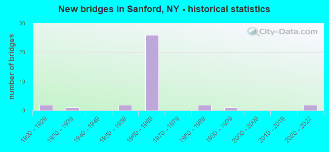
- New bridges - historical statistics
- 21920-1929
- 11930-1939
- 21950-1959
- 261960-1969
- 21980-1989
- 11990-1999
- 22020-2022

- Reconstructed bridges - Historical Statistics
- 61980-1989
- 31990-1999
- 42000-2009
- 22010-2019


- Bridge Condition - Deck
- 19.0%Excellent
- 14.3%Very good
- 42.9%Good
- 14.3%Satisfactory
- 4.8%Fair
- 4.8%Poor

- Bridge Condition - Superstructure
- 14.3%Excellent
- 9.5%Very good
- 23.8%Good
- 33.3%Satisfactory
- 14.3%Fair
- 4.8%Poor

- Bridge Condition - Substructure
- 9.5%Excellent
- 4.8%Very good
- 23.8%Good
- 38.1%Satisfactory
- 23.8%Fair

- Bridge Condition - Channel
- 10.5%Very good
- 31.6%Good
- 52.6%Satisfactory
- 5.3%Fair

- Bridge Condition - Culverts
- 50.0%Very good
- 50.0%Good
Find on map >> Show street view
Structure Number: 101325, Location: 2.5 MI SW JCT SH17 & SH41 (Lat: 42.031428, Lng: -75.529758), Route carried "on" structure: Other road , Year Built: 1960, Year Reconstructed: 2013, Status: Open, Structure Length: 10.88m (35.70ft), Average Daily Traffic: 504 (year 2020), Truck Traffic: 13%, Average Future Daily Traffic: 706 (year 2040), Design Load: HS 20+Mod, Features Intersected: 17 17 91073199 WB, RTE, Facility Carried by Structure: GULF SUMMIT ROAD
Minimum Vertical Clearance: 30+ m (98+ ft), Kilometerpoint: 0.322, Lanes on structure: 2, Lanes under structure: 4, Owner: State Highway Agency, Approaching Roadway Width: 6.7m (22.0ft), Material/Design: Steel, Design/Construction: Stringer/Multi-beam, Number Of Spans In Main Unit: 5, Length of Maximum Span: 23.1m (75.8ft), Curb-To-Curb Width: 9.5m (31.2ft), Out-to-Out Width: 10.8m (35.4ft)
Condition: Deck: Very good, Superstructure: Fair, Substructure: Fair, Channel: Good, Operating Rating: 66.4 metric tons, Method Used To Determine Operating Rating: Load and Resistance Factor Rating (LRFR) rating reported by rating factor(RF) method using HL-93 loadings, Inventory Rating: 51.2 metric tons, Method Used To Determine Inventory Rating: Load and Resistance Factor Rating (LRFR) rating reported by rating factor(RF) method using HL-93 loadings, Structural Evaluation: Somewhat better than minimum adequacy, Deck Geometry: Equal to present minimum criteria, Underclear: Somewhat better than minimum adequacy, Waterway Adequacy: Somewhat better than minimum adequacy, Approach Roadway Alignment: Equal to present desirable criteria, Length Of Structure Improvement: 10.88m (35.70ft), Designated Inspection Frequency: Every 24 months, Inspection Date: October 2021, Bridge Improvement Cost: $2,460,000, Roadway Improvement Cost: $1,440,000, Total Project Cost: $3,900,000 ( Estimate for 2021), Deck Structure Type: Concrete Cast-file-Place, Wearing Surface/Protective System: Wearing Surface: Monolithic Concrete, Deck Protection: Epoxy Coated Reinforcing
Find on map >> Show street view
Structure Number: 101326, Location: 1.4 MI SW JCT RTS 17 + 41 (Lat: 42.040303, Lng: -75.515631), Route carried "on" structure: County highway , Year Built: 1960, Year Reconstructed: 2017, Status: Open, Structure Length: 10.85m (35.60ft), Average Daily Traffic: 527 (year 2020), Truck Traffic: 11%, Average Future Daily Traffic: 738 (year 2040), Design Load: HS 20, Features Intersected: 17 17 91073209 EB, RTE, Facility Carried by Structure: CR 28
Minimum Vertical Clearance: 30+ m (98+ ft), Kilometerpoint: 24.827, Lanes on structure: 2, Lanes under structure: 4, Owner: State Highway Agency, Approaching Roadway Width: 9.8m (32.2ft), Skew: 4 degrees, Material/Design: Steel, Design/Construction: Stringer/Multi-beam, Number Of Spans In Main Unit: 5, Length of Maximum Span: 25.6m (84.0ft), Curb-To-Curb Width: 9.8m (32.2ft), Out-to-Out Width: 11.0m (36.1ft)
Condition: Deck: Excellent, Superstructure: Satisfactory, Substructure: Satisfactory, Channel: Very good, Operating Rating: 84.4 metric tons, Method Used To Determine Operating Rating: Load Factor (LF), Inventory Rating: 49.9 metric tons, Method Used To Determine Inventory Rating: Load Factor (LF), Structural Evaluation: Equal to present minimum criteria, Deck Geometry: Equal to present minimum criteria, Underclear: High priority of corrective action, Waterway Adequacy: Equal to present minimum criteria, Approach Roadway Alignment: Equal to present desirable criteria, Length Of Structure Improvement: 10.85m (35.60ft), Designated Inspection Frequency: Every 24 months, Inspection Date: October 2021, Bridge Improvement Cost: $2,540,000, Roadway Improvement Cost: $1,487,000, Total Project Cost: $4,027,000 ( Estimate for 2021), Deck Structure Type: Concrete Cast-file-Place, Wearing Surface/Protective System: Wearing Surface: Integral Concrete, Deck Protection: Epoxy Coated Reinforcing
Find on map >> Show street view
Structure Number: 1013271, Location: JCT RTS 17 + 41 (Lat: 42.051250, Lng: -75.496794), Route carried "on" structure: State highway 17, Year Built: 1960, Year Reconstructed: 1986, Status: Open, Structure Length: 4.18m (13.71ft), Average Daily Traffic: 4,309 (year 2011), Truck Traffic: 19%, Features Intersected: RTE 41
Minimum Vertical Clearance: 30+ m (98+ ft), Kilometerpoint: 58.407, Lanes on structure: 2, Lanes under structure: 2, Base Highway Network: Yes, Owner: State Highway Agency, Approaching Roadway Width: 11.0m (36.1ft), Skew: 1 degrees, Material/Design: Steel, Design/Construction: Stringer/Multi-beam, Number Of Spans In Main Unit: 3, Length of Maximum Span: 15.2m (49.9ft), Curb-To-Curb Width: 10.9m (35.8ft), Out-to-Out Width: 11.8m (38.7ft)
Condition: Deck: Good, Superstructure: Good, Substructure: Satisfactory, Operating Rating: 74.4 metric tons, Method Used To Determine Operating Rating: Load Factor (LF), Inventory Rating: 44.5 metric tons, Method Used To Determine Inventory Rating: Load Factor (LF), Structural Evaluation: Equal to present minimum criteria, Deck Geometry: Somewhat better than minimum adequacy, Underclear: Equal to present minimum criteria, Approach Roadway Alignment: Equal to present desirable criteria, Length Of Structure Improvement: 4.17m (13.68ft), Designated Inspection Frequency: Every 24 months, Inspection Date: April 2021, Bridge Improvement Cost: $1,150,000, Roadway Improvement Cost: $674,000, Total Project Cost: $1,824,000 ( Estimate for 2021), Deck Structure Type: Concrete Cast-file-Place, Wearing Surface/Protective System: Wearing Surface: Integral Concrete, Deck Protection: Epoxy Coated Reinforcing
Find on map >> Show street view
Structure Number: 1013272, Location: JCT RTS 17 + 41 (Lat: 42.050806, Lng: -75.496808), Route carried "on" structure: State highway 17, Year Built: 1960, Year Reconstructed: 1986, Status: Open, Structure Length: 4.11m (13.48ft), Average Daily Traffic: 3,534 (year 2011), Truck Traffic: 19%, Average Future Daily Traffic: 5,514 (year 2040), Features Intersected: RTE 41
Minimum Vertical Clearance: 30+ m (98+ ft), Kilometerpoint: 58.342, Lanes on structure: 2, Lanes under structure: 2, Base Highway Network: Yes, Owner: State Highway Agency, Approaching Roadway Width: 11.0m (36.1ft), Material/Design: Steel, Design/Construction: Stringer/Multi-beam, Number Of Spans In Main Unit: 3, Length of Maximum Span: 14.6m (47.9ft), Curb-To-Curb Width: 10.9m (35.8ft), Out-to-Out Width: 11.8m (38.7ft)
Condition: Deck: Good, Superstructure: Good, Substructure: Good, Operating Rating: 68.7 metric tons, Method Used To Determine Operating Rating: Load and Resistance Factor Rating (LRFR) rating reported by rating factor(RF) method using HL-93 loadings, Inventory Rating: 52.8 metric tons, Method Used To Determine Inventory Rating: Load and Resistance Factor Rating (LRFR) rating reported by rating factor(RF) method using HL-93 loadings, Structural Evaluation: Better than present minimum criteria, Deck Geometry: Somewhat better than minimum adequacy, Underclear: Equal to present minimum criteria, Approach Roadway Alignment: Equal to present desirable criteria, Length Of Structure Improvement: 4.11m (13.48ft), Designated Inspection Frequency: Every 24 months, Inspection Date: April 2021, Bridge Improvement Cost: $1,146,000, Roadway Improvement Cost: $671,000, Total Project Cost: $1,816,000 ( Estimate for 2021), Deck Structure Type: Concrete Cast-file-Place, Wearing Surface/Protective System: Wearing Surface: Integral Concrete, Deck Protection: Epoxy Coated Reinforcing
Find on map >> Show street view
Structure Number: 1013281, Location: 0.1 MI E EXIT 82 OF SH 17 (Lat: 42.051433, Lng: -75.493492), Route carried "on" structure: State highway 17, Year Built: 1960, Year Reconstructed: 1986, Status: Open, Structure Length: 3.84m (12.60ft), Average Daily Traffic: 3,707 (year 2009), Truck Traffic: 19%, Average Future Daily Traffic: 5,190 (year 2029), Design Load: HS 20, Features Intersected: OQUAGA CREEK
Minimum Vertical Clearance: 30+ m (98+ ft), Kilometerpoint: 58.696, Lanes on structure: 3, Base Highway Network: Yes, Owner: State Highway Agency, Approaching Roadway Width: 15.2m (49.9ft), Material/Design: Steel, Design/Construction: Stringer/Multi-beam, Number Of Spans In Main Unit: 2, Length of Maximum Span: 18.5m (60.7ft), Curb-To-Curb Width: 14.6m (47.9ft), Out-to-Out Width: 15.4m (50.5ft)
Condition: Deck: Good, Superstructure: Good, Substructure: Good, Channel: Satisfactory, Operating Rating: 87.1 metric tons, Method Used To Determine Operating Rating: Load Factor (LF), Inventory Rating: 51.7 metric tons, Method Used To Determine Inventory Rating: Load Factor (LF), Structural Evaluation: Better than present minimum criteria, Deck Geometry: Somewhat better than minimum adequacy, Waterway Adequacy: Equal to present desirable criteria, Approach Roadway Alignment: Equal to present desirable criteria, Length Of Structure Improvement: 3.84m (12.60ft), Designated Inspection Frequency: Every 24 months, Inspection Date: April 2020, Bridge Improvement Cost: $1,395,000, Roadway Improvement Cost: $817,000, Total Project Cost: $2,211,000 ( Estimate for 2021), Deck Structure Type: Concrete Cast-file-Place, Wearing Surface/Protective System: Wearing Surface: Integral Concrete, Deck Protection: Epoxy Coated Reinforcing
Find on map >> Show street view
Structure Number: 1013282, Location: 0.1 MI E JCT RTS 17 + 41 (Lat: 42.051000, Lng: -75.493494), Route carried "on" structure: State highway 17, Year Built: 1960, Year Reconstructed: 1986, Status: Open, Structure Length: 3.84m (12.60ft), Average Daily Traffic: 3,036 (year 2009), Truck Traffic: 19%, Average Future Daily Traffic: 4,737 (year 2040), Design Load: HS 20, Features Intersected: OQUAGA CREEK
Minimum Vertical Clearance: 30+ m (98+ ft), Kilometerpoint: 58.632, Lanes on structure: 3, Base Highway Network: Yes, Owner: State Highway Agency, Approaching Roadway Width: 15.2m (49.9ft), Material/Design: Steel, Design/Construction: Stringer/Multi-beam, Number Of Spans In Main Unit: 2, Length of Maximum Span: 18.5m (60.7ft), Curb-To-Curb Width: 14.6m (47.9ft), Out-to-Out Width: 15.4m (50.5ft)
Condition: Deck: Good, Superstructure: Good, Substructure: Good, Channel: Satisfactory, Operating Rating: 87.1 metric tons, Method Used To Determine Operating Rating: Load Factor (LF), Inventory Rating: 51.7 metric tons, Method Used To Determine Inventory Rating: Load Factor (LF), Structural Evaluation: Better than present minimum criteria, Deck Geometry: Somewhat better than minimum adequacy, Waterway Adequacy: Equal to present desirable criteria, Approach Roadway Alignment: Equal to present desirable criteria, Length Of Structure Improvement: 3.84m (12.60ft), Designated Inspection Frequency: Every 24 months, Inspection Date: April 2020, Bridge Improvement Cost: $1,395,000, Roadway Improvement Cost: $817,000, Total Project Cost: $2,211,000 ( Estimate for 2021), Deck Structure Type: Concrete Cast-file-Place, Wearing Surface/Protective System: Wearing Surface: Integral Concrete, Deck Protection: Epoxy Coated Reinforcing
Find on map >> Show street view
Structure Number: 1013291, Location: 1.0 MI E JCT RTS 17 + 41 (Lat: 42.049992, Lng: -75.475753), Route carried "on" structure: State highway 17, Year Built: 1961, Year Reconstructed: 1989, Status: Open, Structure Length: 3.90m (12.80ft), Average Daily Traffic: 3,106 (year 2009), Truck Traffic: 27%, Design Load: HS 20, Features Intersected: CR 28
Minimum Vertical Clearance: 30+ m (98+ ft), Kilometerpoint: 60.128, Lanes on structure: 2, Lanes under structure: 2, Base Highway Network: Yes, Owner: State Highway Agency, Approaching Roadway Width: 11.6m (38.1ft), Skew: 6 degrees, Material/Design: Steel, Design/Construction: Stringer/Multi-beam, Number Of Spans In Main Unit: 1, Length of Maximum Span: 35.6m (116.8ft), Curb-To-Curb Width: 11.9m (39.0ft), Out-to-Out Width: 12.8m (42.0ft)
Condition: Deck: Satisfactory, Superstructure: Satisfactory, Substructure: Satisfactory, Inventory Rating: 66.2 metric tons, Method Used To Determine Inventory Rating: Load Factor (LF), Structural Evaluation: Equal to present minimum criteria, Deck Geometry: Better than present minimum criteria, Underclear: Equal to present minimum criteria, Approach Roadway Alignment: Equal to present desirable criteria, Length Of Structure Improvement: 3.90m (12.80ft), Designated Inspection Frequency: Every 24 months, Inspection Date: March 2021, Bridge Improvement Cost: $2,961,000, Roadway Improvement Cost: $1,734,000, Total Project Cost: $4,695,000 ( Estimate for 2021), Deck Structure Type: Concrete Cast-file-Place, Wearing Surface/Protective System: Wearing Surface: Integral Concrete, Deck Protection: Epoxy Coated Reinforcing
Find on map >> Show street view
Structure Number: 1013292, Location: 1.0 MI E JCT RTS 17 + 41 (Lat: 42.049919, Lng: -75.476339), Route carried "on" structure: State highway 17, Year Built: 1961, Year Reconstructed: 1989, Status: Open, Structure Length: 3.90m (12.80ft), Average Daily Traffic: 2,544 (year 2009), Truck Traffic: 27%, Average Future Daily Traffic: 3,969 (year 2040), Design Load: HS 20, Features Intersected: CR 28
Minimum Vertical Clearance: 30+ m (98+ ft), Kilometerpoint: 60.064, Lanes on structure: 2, Lanes under structure: 2, Base Highway Network: Yes, Owner: State Highway Agency, Approaching Roadway Width: 11.6m (38.1ft), Skew: 6 degrees, Material/Design: Steel, Design/Construction: Stringer/Multi-beam, Number Of Spans In Main Unit: 1, Length of Maximum Span: 35.6m (116.8ft), Curb-To-Curb Width: 11.9m (39.0ft), Out-to-Out Width: 12.8m (42.0ft)
Condition: Deck: Satisfactory, Superstructure: Satisfactory, Substructure: Satisfactory, Inventory Rating: 66.2 metric tons, Method Used To Determine Inventory Rating: Load Factor (LF), Structural Evaluation: Equal to present minimum criteria, Deck Geometry: Better than present minimum criteria, Underclear: Equal to present minimum criteria, Approach Roadway Alignment: Equal to present desirable criteria, Length Of Structure Improvement: 3.90m (12.80ft), Designated Inspection Frequency: Every 24 months, Inspection Date: March 2021, Bridge Improvement Cost: $3,037,000, Roadway Improvement Cost: $1,778,000, Total Project Cost: $4,816,000 ( Estimate for 2021), Deck Structure Type: Concrete Cast-file-Place, Wearing Surface/Protective System: Wearing Surface: Integral Concrete, Deck Protection: Epoxy Coated Reinforcing
Find on map >> Show street view
Structure Number: 10133, Location: EXIT 83 - RAMP OVER STE (Lat: 42.051906, Lng: -75.444919), Route carried "on" structure: Ramp State highway , Year Built: 1961, Status: Open, Structure Length: 6.07m (19.91ft), Average Daily Traffic: 368 (year 2013), Truck Traffic: 13%, Average Future Daily Traffic: 574 (year 2040), Design Load: HS 20, Features Intersected: 17 17 91073251 EB, RTE 1, Facility Carried by Structure: EXIT RAMP
Minimum Vertical Clearance: 30+ m (98+ ft), Kilometerpoint: 0.434, Lanes on structure: 1, Lanes under structure: 4, Owner: State Highway Agency, Approaching Roadway Width: 5.2m (17.1ft), Material/Design: Steel, Design/Construction: Stringer/Multi-beam, Number Of Spans In Main Unit: 4, Length of Maximum Span: 16.1m (52.8ft), Curb or Sidewalk Widths: Left: 0.5m (1.6ft), Right: 0.5m (1.6ft), Curb-To-Curb Width: 5.5m (18.0ft), Out-to-Out Width: 7.1m (23.3ft)
Condition: Deck: Fair, Superstructure: Fair, Substructure: Fair, Operating Rating: 78.0 metric tons, Method Used To Determine Operating Rating: Load Factor (LF), Inventory Rating: 47.2 metric tons, Method Used To Determine Inventory Rating: Load Factor (LF), Structural Evaluation: Somewhat better than minimum adequacy, Deck Geometry: Meets minimum limits, Underclear: Meets minimum limits, Approach Roadway Alignment: Equal to present desirable criteria, Length Of Structure Improvement: 6.06m (19.88ft), Designated Inspection Frequency: Every 24 months, Inspection Date: July 2020, Bridge Improvement Cost: $934,000, Roadway Improvement Cost: $547,000, Total Project Cost: $1,481,000 ( Estimate for 2021), Deck Structure Type: Concrete Cast-file-Place, Wearing Surface/Protective System: Wearing Surface: Bituminous, Membrane: Other
Find on map >> Show street view
Structure Number: 1013311, Location: 3.1 MI E JCT SH 17 & SH41 (Lat: 42.051964, Lng: -75.441261), Route carried "on" structure: State highway 17, Year Built: 1961, Year Reconstructed: 2013, Status: Open, Structure Length: 12.98m (42.59ft), Average Daily Traffic: 3,106 (year 2009), Truck Traffic: 27%, Design Load: HS 20, Features Intersected: N-S RR, OQUAGA CREEK
Minimum Vertical Clearance: 30+ m (98+ ft), Kilometerpoint: 63.411, Lanes on structure: 2, Base Highway Network: Yes, Owner: State Highway Agency, Approaching Roadway Width: 12.2m (40.0ft), Skew: 4 degrees, Material/Design: Steel, Design/Construction: Stringer/Multi-beam, Number Of Spans In Main Unit: 5, Length of Maximum Span: 27.1m (88.9ft), Curb-To-Curb Width: 10.7m (35.1ft), Out-to-Out Width: 11.6m (38.1ft)
Condition: Deck: Good, Superstructure: Fair, Substructure: Fair, Channel: Satisfactory, Operating Rating: 88.0 metric tons, Method Used To Determine Operating Rating: Load Factor (LF), Inventory Rating: 52.6 metric tons, Method Used To Determine Inventory Rating: Load Factor (LF), Structural Evaluation: Somewhat better than minimum adequacy, Deck Geometry: Somewhat better than minimum adequacy, Underclear: Superior to present desirable criteria, Waterway Adequacy: Equal to present minimum criteria, Approach Roadway Alignment: Equal to present desirable criteria, Length Of Structure Improvement: 12.98m (42.59ft), Designated Inspection Frequency: Every 24 months, Inspection Date: September 2021, Bridge Improvement Cost: $3,179,000, Roadway Improvement Cost: $1,862,000, Total Project Cost: $5,041,000 ( Estimate for 2021), Deck Structure Type: Concrete Cast-file-Place, Wearing Surface/Protective System: Wearing Surface: Epoxy Overlay, Deck Protection: Epoxy Coated Reinforcing
Find on map >> Show street view
Structure Number: 1013312, Location: 3.1 MI E JCT SH 17 & SH41 (Lat: 42.051814, Lng: -75.441525), Route carried "on" structure: State highway 17, Year Built: 1961, Year Reconstructed: 2013, Status: Open, Structure Length: 12.98m (42.59ft), Average Daily Traffic: 2,544 (year 2009), Truck Traffic: 27%, Average Future Daily Traffic: 3,969 (year 2040), Design Load: HS 20, Features Intersected: N-S RR MP 176.86, OQUAGA
Minimum Vertical Clearance: 30+ m (98+ ft), Kilometerpoint: 63.346, Lanes on structure: 2, Base Highway Network: Yes, Owner: State Highway Agency, Approaching Roadway Width: 12.2m (40.0ft), Skew: 4 degrees, Material/Design: Steel, Design/Construction: Stringer/Multi-beam, Number Of Spans In Main Unit: 5, Length of Maximum Span: 27.1m (88.9ft), Curb-To-Curb Width: 10.7m (35.1ft), Out-to-Out Width: 11.6m (38.1ft)
Condition: Deck: Good, Superstructure: Satisfactory, Substructure: Satisfactory, Channel: Satisfactory, Operating Rating: 88.9 metric tons, Method Used To Determine Operating Rating: Load Factor (LF), Inventory Rating: 52.6 metric tons, Method Used To Determine Inventory Rating: Load Factor (LF), Structural Evaluation: Equal to present minimum criteria, Deck Geometry: Somewhat better than minimum adequacy, Underclear: Equal to present minimum criteria, Waterway Adequacy: Equal to present minimum criteria, Approach Roadway Alignment: Equal to present desirable criteria, Length Of Structure Improvement: 12.98m (42.59ft), Designated Inspection Frequency: Every 24 months, Inspection Date: September 2021, Bridge Improvement Cost: $3,179,000, Roadway Improvement Cost: $1,862,000, Total Project Cost: $5,041,000 ( Estimate for 2021), Deck Structure Type: Concrete Cast-file-Place, Wearing Surface/Protective System: Wearing Surface: Integral Concrete, Deck Protection: Epoxy Coated Reinforcing
Find on map >> Show street view
Structure Number: 101332, Location: 4.0 MI E JCT RTS 17 + 41 (Lat: 42.055619, Lng: -75.424792), Route carried "on" structure: County highway , Year Built: 1961, Year Reconstructed: 2012, Status: Open, Structure Length: 6.92m (22.70ft), Average Daily Traffic: 655 (year 2018), Truck Traffic: 9%, Average Future Daily Traffic: 917 (year 2038), Design Load: HS 20, Features Intersected: 17 17 91073262 WB, RTE, Facility Carried by Structure: OQUAGA LAKE ROAD
Minimum Vertical Clearance: 30+ m (98+ ft), Kilometerpoint: 10.700, Lanes on structure: 2, Lanes under structure: 4, Owner: State Highway Agency, Approaching Roadway Width: 7.9m (25.9ft), Material/Design: Steel, Design/Construction: Stringer/Multi-beam, Number Of Spans In Main Unit: 4, Length of Maximum Span: 18.5m (60.7ft), Curb-To-Curb Width: 7.9m (25.9ft), Out-to-Out Width: 9.5m (31.2ft)
Condition: Deck: Very good, Superstructure: Good, Substructure: Fair, Operating Rating: 87.1 metric tons, Method Used To Determine Operating Rating: Load Factor (LF), Inventory Rating: 51.7 metric tons, Method Used To Determine Inventory Rating: Load Factor (LF), Structural Evaluation: Somewhat better than minimum adequacy, Deck Geometry: Somewhat better than minimum adequacy, Underclear: Meets minimum limits, Approach Roadway Alignment: Equal to present desirable criteria, Length Of Structure Improvement: 6.91m (22.67ft), Designated Inspection Frequency: Every 24 months, Inspection Date: June 2021, Bridge Improvement Cost: $1,439,000, Roadway Improvement Cost: $843,000, Total Project Cost: $2,282,000 ( Estimate for 2021), Deck Structure Type: Concrete Cast-file-Place, Wearing Surface/Protective System: Wearing Surface: Monolithic Concrete, Deck Protection: Epoxy Coated Reinforcing
Find on map >> Show street view
Structure Number: 1013331, Location: JCT SH17 & W B DELAWARE R (Lat: 42.055925, Lng: -75.423136), Route carried "on" structure: State highway 17, Year Built: 1961, Year Reconstructed: 1990, Status: Open, Structure Length: 19.20m (62.99ft), Average Daily Traffic: 3,221 (year 2009), Truck Traffic: 19%, Average Future Daily Traffic: 5,025 (year 2040), Design Load: HS 20, Features Intersected: LAUREL BANK AVE, W BR DE
Minimum Vertical Clearance: 30+ m (98+ ft), Kilometerpoint: 0.000, Lanes on structure: 2, Lanes under structure: 2, Base Highway Network: Yes, Owner: State Highway Agency, Approaching Roadway Width: 11.0m (36.1ft), Material/Design: Steel, Design/Construction: Stringer/Multi-beam, Number Of Spans In Main Unit: 6, Length of Maximum Span: 31.6m (103.7ft), Curb-To-Curb Width: 10.7m (35.1ft), Out-to-Out Width: 11.6m (38.1ft)
Condition: Deck: Good, Superstructure: Satisfactory, Substructure: Good, Channel: Good, Operating Rating: 69.9 metric tons, Method Used To Determine Operating Rating: Load Factor (LF), Inventory Rating: 41.7 metric tons, Method Used To Determine Inventory Rating: Load Factor (LF), Structural Evaluation: Equal to present minimum criteria, Deck Geometry: Somewhat better than minimum adequacy, Underclear: Meets minimum limits, Waterway Adequacy: Equal to present minimum criteria, Approach Roadway Alignment: Equal to present desirable criteria, Length Of Structure Improvement: 19.20m (62.99ft), Designated Inspection Frequency: Every 24 months, Inspection Date: July 2020, Bridge Improvement Cost: $4,622,000, Roadway Improvement Cost: $2,707,000, Total Project Cost: $7,329,000 ( Estimate for 2021), Deck Structure Type: Concrete Cast-file-Place, Wearing Surface/Protective System: Wearing Surface: Integral Concrete, Deck Protection: Epoxy Coated Reinforcing
Find on map >> Show street view
Structure Number: 1013332, Location: JCT SH17 & W B DELAWARE R (Lat: 42.055681, Lng: -75.422319), Route carried "on" structure: State highway 17, Year Built: 1961, Year Reconstructed: 1990, Status: Open, Structure Length: 18.07m (59.28ft), Average Daily Traffic: 3,221 (year 2009), Truck Traffic: 19%, Average Future Daily Traffic: 5,025 (year 2040), Design Load: HS 20, Features Intersected: LAUREL BANK AVE, W BR DE
Minimum Vertical Clearance: 30+ m (98+ ft), Kilometerpoint: 0.000, Lanes on structure: 2, Lanes under structure: 2, Base Highway Network: Yes, Owner: State Highway Agency, Approaching Roadway Width: 11.0m (36.1ft), Material/Design: Steel, Design/Construction: Stringer/Multi-beam, Number Of Spans In Main Unit: 6, Length of Maximum Span: 30.7m (100.7ft), Curb-To-Curb Width: 10.7m (35.1ft), Out-to-Out Width: 11.6m (38.1ft)
Condition: Deck: Good, Superstructure: Satisfactory, Substructure: Good, Channel: Good, Operating Rating: 78.0 metric tons, Method Used To Determine Operating Rating: Load Factor (LF), Inventory Rating: 46.3 metric tons, Method Used To Determine Inventory Rating: Load Factor (LF), Structural Evaluation: Equal to present minimum criteria, Deck Geometry: Somewhat better than minimum adequacy, Underclear: Meets minimum limits, Waterway Adequacy: Equal to present minimum criteria, Approach Roadway Alignment: Equal to present desirable criteria, Length Of Structure Improvement: 18.07m (59.28ft), Designated Inspection Frequency: Every 24 months, Inspection Date: July 2020, Bridge Improvement Cost: $4,336,000, Roadway Improvement Cost: $2,539,000, Total Project Cost: $6,875,000 ( Estimate for 2021), Deck Structure Type: Concrete Cast-file-Place, Wearing Surface/Protective System: Wearing Surface: Epoxy Overlay, Deck Protection: Epoxy Coated Reinforcing
Find on map >> Show street view
Structure Number: 102473, Location: 0.5 MI N JCT RTS 41 + 17 (Lat: 42.058247, Lng: -75.494939), Route carried "on" structure: State highway 41, Year Built: 1927, Status: Open, Structure Length: 1.04m (3.41ft), Average Daily Traffic: 728 (year 2020), Truck Traffic: 16%, Average Future Daily Traffic: 759 (year 2040), Features Intersected: MARSH CREEK
Minimum Vertical Clearance: 30+ m (98+ ft), Kilometerpoint: 0.885, Lanes on structure: 2, Base Highway Network: Yes, Owner: State Highway Agency, Approaching Roadway Width: 9.4m (30.8ft), Skew: 3 degrees, Material/Design: Steel, Design/Construction: Stringer/Multi-beam, Number Of Spans In Main Unit: 1, Length of Maximum Span: 10.0m (32.8ft), Curb-To-Curb Width: 10.0m (32.8ft), Out-to-Out Width: 10.5m (34.4ft)
Condition: Deck: Poor, Superstructure: Poor, Substructure: Fair, Channel: Satisfactory, Operating Rating: 39.9 metric tons, Method Used To Determine Operating Rating: Load and Resistance Factor Rating (LRFR) rating reported by rating factor(RF) method using HL-93 loadings, Inventory Rating: 30.8 metric tons, Method Used To Determine Inventory Rating: Load and Resistance Factor Rating (LRFR) rating reported by rating factor(RF) method using HL-93 loadings, Structural Evaluation: Meets minimum limits, Deck Geometry: Equal to present minimum criteria, Waterway Adequacy: Meets minimum limits, Approach Roadway Alignment: Meets minimum limits, Length Of Structure Improvement: 1.03m (3.38ft), Designated Inspection Frequency: Every 24 months, Inspection Date: July 2021, Bridge Improvement Cost: $419,000, Roadway Improvement Cost: $246,000, Total Project Cost: $665,000 ( Estimate for 2021), Deck Structure Type: Concrete Cast-file-Place, Wearing Surface/Protective System: Wearing Surface: Bituminous
Find on map >> Show street view
Structure Number: 109403, Location: 0.1 MI S JCT RTS 41 + 17 (Lat: 42.049853, Lng: -75.496514), Route carried "on" structure: State highway 41, Year Built: 1927, Year Reconstructed: 2018, Status: Open, Structure Length: 0.82m (2.69ft), Average Daily Traffic: 728 (year 2020), Truck Traffic: 16%, Average Future Daily Traffic: 759 (year 2040), Features Intersected: FLY CREEK
Minimum Vertical Clearance: 30+ m (98+ ft), Kilometerpoint: 0.016, Lanes on structure: 2, Base Highway Network: Yes, Owner: State Highway Agency, Approaching Roadway Width: 7.3m (24.0ft), Material/Design: Concrete, Design/Construction: Slab, Number Of Spans In Main Unit: 1, Length of Maximum Span: 7.3m (24.0ft), Curb-To-Curb Width: 9.9m (32.5ft), Out-to-Out Width: 10.4m (34.1ft)
Condition: Deck: Excellent, Superstructure: Excellent, Substructure: Satisfactory, Channel: Satisfactory, Inventory Rating: 63.5 metric tons, Method Used To Determine Inventory Rating: Load Factor (LF), Structural Evaluation: Equal to present minimum criteria, Deck Geometry: Equal to present minimum criteria, Waterway Adequacy: Somewhat better than minimum adequacy, Approach Roadway Alignment: Equal to present desirable criteria, Length Of Structure Improvement: 0.82m (2.69ft), Designated Inspection Frequency: Every 24 months, Inspection Date: June 2020, Bridge Improvement Cost: $434,000, Roadway Improvement Cost: $254,000, Total Project Cost: $688,000 ( Estimate for 2021), Wearing Surface/Protective System: Wearing Surface: Integral Concrete
Find on map >> Show street view
Structure Number: 222567, Location: 2 MILES NE OF SANFORD (Lat: 42.130139, Lng: -75.464653), Route carried "on" structure: Other road , Year Built: 1950, Year Reconstructed: 1990, Status: Posted for load, Structure Length: 1.62m (5.31ft), Average Daily Traffic: 53 (year 2017), Truck Traffic: 5%, Average Future Daily Traffic: 74 (year 2037), Features Intersected: OQUAGA CREEK, Facility Carried by Structure: CLARK ROAD
Minimum Vertical Clearance: 30+ m (98+ ft), Kilometerpoint: 0.547, Lanes on structure: 1, Owner: Town or Township Highway Agency, Approaching Roadway Width: 5.5m (18.0ft), Material/Design: Wood or Timber, Design/Construction: Stringer/Multi-beam, Number Of Spans In Main Unit: 1, Length of Maximum Span: 15.8m (51.8ft), Curb-To-Curb Width: 5.0m (16.4ft), Out-to-Out Width: 5.4m (17.7ft)
Condition: Deck: Very good, Superstructure: Very good, Substructure: Satisfactory, Channel: Satisfactory, Operating Rating: 28.1 metric tons, Method Used To Determine Operating Rating: Allowable Stress (AS), Inventory Rating: 16.3 metric tons, Method Used To Determine Inventory Rating: Allowable Stress (AS), Structural Evaluation: Somewhat better than minimum adequacy, Deck Geometry: High priority of corrective action, Waterway Adequacy: Meets minimum limits, Approach Roadway Alignment: Equal to present desirable criteria, Bridge Posting: Required (Relationship of Operating Rating to Maximum Legal Load: > 39.9% below), Length Of Structure Improvement: 1.61m (5.28ft), Designated Inspection Frequency: Every 12 months, Inspection Date: June 2021, Bridge Improvement Cost: $265,000, Roadway Improvement Cost: $155,000, Total Project Cost: $420,000 ( Estimate for 2021), Deck Structure Type: Wood or Timber, Wearing Surface/Protective System: Wearing Surface: Bituminous
Find on map >> Show street view
Structure Number: 222568, Location: HAMLET OF NORTH SANFORD (Lat: 42.158961, Lng: -75.454869), Route carried "on" structure: Other road , Year Built: 1964, Status: Open, Structure Length: 1.04m (3.41ft), Average Daily Traffic: 118 (year 2016), Truck Traffic: 5%, Average Future Daily Traffic: 165 (year 2036), Features Intersected: OQUAGA CREEK, Facility Carried by Structure: MELONDY HILL ROAD
Minimum Vertical Clearance: 30+ m (98+ ft), Kilometerpoint: 0.386, Lanes on structure: 2, Owner: Town or Township Highway Agency, Approaching Roadway Width: 7.3m (24.0ft), Material/Design: Steel, Design/Construction: Culvert, Number Of Spans In Main Unit: 2, Length of Maximum Span: 4.8m (15.7ft)
Condition: Channel: Fair, Culverts: Good, Operating Rating: 76.0 metric tons, Method Used To Determine Operating Rating: Field evaluation and documented engineering judgment, Inventory Rating: 32.7 metric tons, Method Used To Determine Inventory Rating: Field evaluation and documented engineering judgment, Structural Evaluation: Better than present minimum criteria, Waterway Adequacy: Somewhat better than minimum adequacy, Approach Roadway Alignment: Equal to present minimum criteria, Length Of Structure Improvement: 1.03m (3.38ft), Designated Inspection Frequency: Every 24 months, Inspection Date: July 2020, Bridge Improvement Cost: $134,000, Roadway Improvement Cost: $79,000, Total Project Cost: $213,000 ( Estimate for 2021)
Find on map >> Show street view
Structure Number: 33496, Location: VILLAGE OF HALE EDDY (Lat: 42.001756, Lng: -75.394978), Route carried "on" structure: County highway , Year Built: 1957, Status: Open, Structure Length: 1.34m (4.40ft), Average Daily Traffic: 623 (year 2018), Truck Traffic: 7%, Average Future Daily Traffic: 872 (year 2038), Design Load: HS 20, Features Intersected: SHERMAN CREEK, Facility Carried by Structure: SHERMAN CREEK RD
Minimum Vertical Clearance: 30+ m (98+ ft), Kilometerpoint: 0.193, Lanes on structure: 2, Owner: County Highway Agency, Approaching Roadway Width: 5.5m (18.0ft), Skew: 4 degrees, Material/Design: Prestressed concrete, Design/Construction: Box Beam or Girders - Multiple, Number Of Spans In Main Unit: 1, Length of Maximum Span: 12.1m (39.7ft), Curb-To-Curb Width: 8.4m (27.6ft), Out-to-Out Width: 9.3m (30.5ft)
Condition: Deck: Satisfactory, Superstructure: Satisfactory, Substructure: Satisfactory, Channel: Satisfactory, Operating Rating: 80.4 metric tons, Method Used To Determine Operating Rating: Field evaluation and documented engineering judgment, Inventory Rating: 29.4 metric tons, Method Used To Determine Inventory Rating: Field evaluation and documented engineering judgment, Structural Evaluation: Equal to present minimum criteria, Deck Geometry: Somewhat better than minimum adequacy, Waterway Adequacy: Somewhat better than minimum adequacy, Approach Roadway Alignment: Meets minimum limits, Length Of Structure Improvement: 1.34m (4.40ft), Designated Inspection Frequency: Every 24 months, Inspection Date: June 2020, Bridge Improvement Cost: $535,000, Roadway Improvement Cost: $313,000, Total Project Cost: $849,000 ( Estimate for 2021), Wearing Surface/Protective System: Wearing Surface: Bituminous
Find on map >> Show street view
Structure Number: 334962, Location: HAMLET OF MCCLURE (Lat: 42.048633, Lng: -75.485233), Route carried "on" structure: County highway , Year Built: 2020, Status: Open, Structure Length: 2.90m (9.51ft), Average Daily Traffic: 527 (year 2020), Truck Traffic: 11%, Average Future Daily Traffic: 738 (year 2040), Design Load: HL 93, Features Intersected: OQUAGA CREEK, Facility Carried by Structure: COUNTY ROAD 28
Minimum Vertical Clearance: 30+ m (98+ ft), Kilometerpoint: 25.889, Lanes on structure: 2, Owner: County Highway Agency, Approaching Roadway Width: 9.8m (32.2ft), Skew: 3 degrees, Material/Design: Steel, Design/Construction: Stringer/Multi-beam, Number Of Spans In Main Unit: 1, Length of Maximum Span: 27.7m (90.9ft), Curb-To-Curb Width: 9.1m (29.9ft), Out-to-Out Width: 10.2m (33.5ft)
Condition: Deck: Excellent, Superstructure: Excellent, Substructure: Excellent, Channel: Satisfactory, Operating Rating: 74.4 metric tons, Method Used To Determine Operating Rating: Load Factor (LF), Inventory Rating: 44.5 metric tons, Method Used To Determine Inventory Rating: Load Factor (LF), Structural Evaluation: Superior to present desirable criteria, Deck Geometry: Equal to present minimum criteria, Waterway Adequacy: Somewhat better than minimum adequacy, Approach Roadway Alignment: Equal to present desirable criteria, Length Of Structure Improvement: 2.89m (9.48ft), Designated Inspection Frequency: Every 24 months, Inspection Date: October 2020, Bridge Improvement Cost: $725,000, Roadway Improvement Cost: $425,000, Total Project Cost: $1,149,000 ( Estimate for 2021), Deck Structure Type: Concrete Cast-file-Place, Wearing Surface/Protective System: Wearing Surface: Integral Concrete, Deck Protection: Epoxy Coated Reinforcing
Find on map >> Show street view
Structure Number: 334963, Location: AT HAMLET OF SANFORD (Lat: 42.102589, Lng: -75.481547), Route carried "on" structure: County highway , Year Built: 2021, Status: Open, Structure Length: 3.08m (10.10ft), Average Daily Traffic: 230 (year 2017), Truck Traffic: 9%, Average Future Daily Traffic: 239 (year 2040), Features Intersected: OQUAGA CREEK, Facility Carried by Structure: NORTH SANFORD RD
Minimum Vertical Clearance: 30+ m (98+ ft), Kilometerpoint: 0.129, Lanes on structure: 2, Owner: County Highway Agency, Approaching Roadway Width: 7.9m (25.9ft), Skew: 4 degrees, Material/Design: Prestressed concrete, Design/Construction: Box Beam or Girders - Multiple, Number Of Spans In Main Unit: 1, Length of Maximum Span: 29.3m (96.1ft), Curb-To-Curb Width: 7.9m (25.9ft), Out-to-Out Width: 8.9m (29.2ft)
Condition: Deck: Excellent, Superstructure: Excellent, Substructure: Excellent, Channel: Very good, Operating Rating: 35.4 metric tons, Method Used To Determine Operating Rating: Load Factor (LF), Inventory Rating: 21.8 metric tons, Method Used To Determine Inventory Rating: Load Factor (LF), Structural Evaluation: Equal to present minimum criteria, Deck Geometry: Somewhat better than minimum adequacy, Waterway Adequacy: Meets minimum limits, Approach Roadway Alignment: Equal to present minimum criteria, Length Of Structure Improvement: 2.22m (7.28ft), Designated Inspection Frequency: Every 24 months, Inspection Date: October 2021, Bridge Improvement Cost: $451,000, Roadway Improvement Cost: $264,000, Total Project Cost: $716,000 ( Estimate for 2021), Deck Structure Type: Concrete Cast-file-Place, Wearing Surface/Protective System: Wearing Surface: Integral Concrete, Deck Protection: Epoxy Coated Reinforcing
Find on map >> Show street view
Structure Number: 334964, Location: 1.0 MI NW OF SAN FORD (Lat: 42.119128, Lng: -75.470819), Route carried "on" structure: Other road , Year Built: 1988, Status: Open, Structure Length: 2.13m (6.99ft), Average Daily Traffic: 17 (year 2017), Truck Traffic: 5%, Average Future Daily Traffic: 24 (year 2037), Features Intersected: OQUAGA CREEK, Facility Carried by Structure: PAGE POND ROAD
Minimum Vertical Clearance: 30+ m (98+ ft), Kilometerpoint: 0.193, Lanes on structure: 2, Owner: County Highway Agency, Approaching Roadway Width: 7.3m (24.0ft), Material/Design: Wood or Timber, Design/Construction: Stringer/Multi-beam, Number Of Spans In Main Unit: 1, Length of Maximum Span: 21.0m (68.9ft), Curb-To-Curb Width: 7.3m (24.0ft), Out-to-Out Width: 7.7m (25.3ft)
Condition: Deck: Good, Superstructure: Very good, Substructure: Very good, Channel: Satisfactory, Operating Rating: 41.7 metric tons, Method Used To Determine Operating Rating: Allowable Stress (AS), Inventory Rating: 27.2 metric tons, Method Used To Determine Inventory Rating: Allowable Stress (AS), Structural Evaluation: Equal to present minimum criteria, Deck Geometry: Equal to present minimum criteria, Waterway Adequacy: Meets minimum limits, Approach Roadway Alignment: Equal to present desirable criteria, Length Of Structure Improvement: 2.13m (6.99ft), Designated Inspection Frequency: Every 24 months, Inspection Date: October 2021, Bridge Improvement Cost: $529,000, Roadway Improvement Cost: $310,000, Total Project Cost: $839,000 ( Estimate for 2021), Deck Structure Type: Wood or Timber, Wearing Surface/Protective System: Wearing Surface: Bituminous
Find on map >> Show street view
Structure Number: 334965, Location: 2 MI N OF DEPOSIT (Lat: 42.084142, Lng: -75.430597), Route carried "on" structure: County highway , Year Built: 1993, Status: Open, Structure Length: 0.94m (3.08ft), Average Daily Traffic: 119 (year 2018), Truck Traffic: 1%, Average Future Daily Traffic: 167 (year 2038), Design Load: HS 20, Features Intersected: BIG HOLLOW CREEK, Facility Carried by Structure: BIG HOLLOW ROAD
Minimum Vertical Clearance: 30+ m (98+ ft), Kilometerpoint: 1.786, Lanes on structure: 2, Owner: County Highway Agency, Approaching Roadway Width: 5.5m (18.0ft), Skew: 5 degrees, Material/Design: Aluminum, Iron, Design/Construction: Culvert, Number Of Spans In Main Unit: 1, Length of Maximum Span: 9.1m (29.9ft)
Condition: Channel: Good, Culverts: Very good, Operating Rating: 79.1 metric tons, Method Used To Determine Operating Rating: Field evaluation and documented engineering judgment, Inventory Rating: 32.7 metric tons, Method Used To Determine Inventory Rating: Field evaluation and documented engineering judgment, Structural Evaluation: Equal to present desirable criteria, Waterway Adequacy: Meets minimum limits, Approach Roadway Alignment: Equal to present desirable criteria, Length Of Structure Improvement: 0.94m (3.08ft), Designated Inspection Frequency: Every 24 months, Inspection Date: August 2020, Bridge Improvement Cost: $92,000, Roadway Improvement Cost: $54,000, Total Project Cost: $145,000 ( Estimate for 2021)
Find on map >> Show street view
Structure Number: 336713, Location: 2 MI NE OF NORTH SANFORD (Lat: 42.174606, Lng: -75.439147), Route carried "on" structure: County highway , Year Built: 1966, Status: Open, Structure Length: 0.82m (2.69ft), Average Daily Traffic: 54 (year 2017), Truck Traffic: 9%, Average Future Daily Traffic: 56 (year 2040), Design Load: H 20, Features Intersected: OQUAGA CREEK, Facility Carried by Structure: NORTH SANFORD RD
Minimum Vertical Clearance: 30+ m (98+ ft), Kilometerpoint: 9.445, Lanes on structure: 2, Owner: County Highway Agency, Approaching Roadway Width: 6.1m (20.0ft), Skew: 5 degrees, Material/Design: Steel, Design/Construction: Culvert, Number Of Spans In Main Unit: 1, Length of Maximum Span: 7.9m (25.9ft)
Condition: Channel: Good, Culverts: Very good, Operating Rating: 70.5 metric tons, Method Used To Determine Operating Rating: Field evaluation and documented engineering judgment, Inventory Rating: 30.6 metric tons, Method Used To Determine Inventory Rating: Field evaluation and documented engineering judgment, Structural Evaluation: Better than present minimum criteria, Waterway Adequacy: Somewhat better than minimum adequacy, Approach Roadway Alignment: Equal to present desirable criteria, Length Of Structure Improvement: 0.82m (2.69ft), Designated Inspection Frequency: Every 24 months, Inspection Date: July 2020, Bridge Improvement Cost: $89,000, Roadway Improvement Cost: $52,000, Total Project Cost: $141,000 ( Estimate for 2021)
Find on map >> Show street view
Structure Number: 336799, Location: 1.5 MILES N OF DEPOSIT (Lat: 42.074708, Lng: -75.424450), Route carried "on" structure: Alternate County highway , Year Built: 1989, Status: Open, Structure Length: 0.73m (2.40ft), Average Daily Traffic: 119 (year 2018), Truck Traffic: 1%, Average Future Daily Traffic: 167 (year 2038), Design Load: HS 20, Features Intersected: BIG HOLLOW CREEK, Facility Carried by Structure: BIG HOLLOW ROAD
Minimum Vertical Clearance: 30+ m (98+ ft), Kilometerpoint: 2.043, Lanes on structure: 2, Owner: County Highway Agency, Approaching Roadway Width: 6.4m (21.0ft), Skew: 4 degrees, Material/Design: Steel, Design/Construction: Culvert, Number Of Spans In Main Unit: 1, Length of Maximum Span: 7.0m (23.0ft)
Condition: Channel: Good, Culverts: Good, Operating Rating: 77.6 metric tons, Method Used To Determine Operating Rating: Field evaluation and documented engineering judgment, Inventory Rating: 32.7 metric tons, Method Used To Determine Inventory Rating: Field evaluation and documented engineering judgment, Structural Evaluation: Better than present minimum criteria, Waterway Adequacy: Equal to present minimum criteria, Approach Roadway Alignment: Equal to present desirable criteria, Length Of Structure Improvement: 0.73m (2.40ft), Designated Inspection Frequency: Every 24 months, Inspection Date: August 2020, Bridge Improvement Cost: $83,000, Roadway Improvement Cost: $49,000, Total Project Cost: $132,000 ( Estimate for 2021)
Find on map >> Show street view
Structure Number: 101325, Location: 2.5 MI SW JCT SH17 & SH41 (Lat: 42.031428, Lng: -75.529758), Route carried "under" structure: State highway 17, Year Built: 1960, Structure Length: 0. m, Average Daily Traffic: 9,034 (year 1992), Features Intersected: 17 17 91073199 WB, RTE, Facility Carried by Structure: GULF SUMMIT ROAD
Minimum Vertical Clearance: 5.03m (16.50ft), Kilometerpoint: 31.826, Lanes on structure: 2, Lanes under structure: 2, Material/Design: Steel, Design/Construction: Stringer/Multi-beam, Length of Maximum Span: 23.1m (75.8ft)
Find on map >> Show street view
Structure Number: 101326, Location: 1.4 MI SW JCT RTS 17 + 41 (Lat: 42.040303, Lng: -75.515631), Route carried "under" structure: State highway 17, Year Built: 1960, Structure Length: 0. m, Features Intersected: 17 17 91073209 EB, RTE, Facility Carried by Structure: CR 28
Minimum Vertical Clearance: 4.42m (14.50ft), Kilometerpoint: 56.556, Lanes on structure: 2, Lanes under structure: 2, Material/Design: Steel, Design/Construction: Stringer/Multi-beam, Length of Maximum Span: 25.6m (84.0ft)
Find on map >> Show street view
Structure Number: 1013271, Location: JCT RTS 17 + 41 (Lat: 42.051250, Lng: -75.496794), Route carried "under" structure: State highway 41, Year Built: 1960, Structure Length: 0. m, Average Daily Traffic: 659 (year 1999), Features Intersected: RTE 41, Facility Carried by Structure: RTE 17
Minimum Vertical Clearance: 4.70m (15.42ft), Kilometerpoint: 0.161, Lanes on structure: 2, Lanes under structure: 2, Material/Design: Steel, Design/Construction: Stringer/Multi-beam, Length of Maximum Span: 15.2m (49.9ft)
Find on map >> Show street view
Structure Number: 1013272, Location: JCT RTS 17 + 41 (Lat: 42.050806, Lng: -75.496808), Route carried "under" structure: State highway 41, Year Built: 1960, Structure Length: 0. m, Average Daily Traffic: 659 (year 1999), Features Intersected: RTE 41, Facility Carried by Structure: RTE 17
Minimum Vertical Clearance: 4.52m (14.83ft), Kilometerpoint: 0.161, Lanes on structure: 2, Lanes under structure: 2, Material/Design: Steel, Design/Construction: Stringer/Multi-beam, Length of Maximum Span: 14.6m (47.9ft)
Find on map >> Show street view
Structure Number: 1013291, Location: 1.0 MI E JCT RTS 17 + 41 (Lat: 42.049992, Lng: -75.475753), Route carried "under" structure: Alternate County highway , Year Built: 1961, Structure Length: 0. m, Average Daily Traffic: 775 (year 1979), Features Intersected: CR 28, Facility Carried by Structure: RTE 17
Minimum Vertical Clearance: 4.72m (15.49ft), Kilometerpoint: 0.000, Lanes on structure: 2, Lanes under structure: 2, Material/Design: Steel, Design/Construction: Stringer/Multi-beam, Length of Maximum Span: 35.6m (116.8ft)
Find on map >> Show street view
Structure Number: 1013292, Location: 1.0 MI E JCT RTS 17 + 41 (Lat: 42.049919, Lng: -75.476339), Route carried "under" structure: Alternate County highway , Year Built: 1961, Structure Length: 0. m, Average Daily Traffic: 775 (year 1979), Features Intersected: CR 28, Facility Carried by Structure: RTE 17
Minimum Vertical Clearance: 5.68m (18.64ft), Kilometerpoint: 0.000, Lanes on structure: 2, Lanes under structure: 2, Material/Design: Steel, Design/Construction: Stringer/Multi-beam, Length of Maximum Span: 35.6m (116.8ft)
Find on map >> Show street view
Structure Number: 10133, Location: EXIT 83 - RAMP OVER STE (Lat: 42.051906, Lng: -75.444919), Route carried "under" structure: State highway 17, Year Built: 1961, Structure Length: 0. m, Average Daily Traffic: 7,263 (year 1998), Features Intersected: 17 17 91073251 EB, RTE 1, Facility Carried by Structure: EXIT RAMP
Minimum Vertical Clearance: 5.35m (17.55ft), Kilometerpoint: 40.322, Lanes on structure: 1, Lanes under structure: 2, Material/Design: Steel, Design/Construction: Stringer/Multi-beam, Length of Maximum Span: 16.1m (52.8ft)
Find on map >> Show street view
Structure Number: 101332, Location: 4.0 MI E JCT RTS 17 + 41 (Lat: 42.055619, Lng: -75.424792), Route carried "under" structure: State highway 17, Year Built: 1961, Structure Length: 0. m, Average Daily Traffic: 7,263 (year 1998), Features Intersected: 17 17 91073262 WB, RTE, Facility Carried by Structure: OQUAGA LAKE ROAD
Minimum Vertical Clearance: 7.54m (24.74ft), Kilometerpoint: 42.091, Lanes on structure: 2, Lanes under structure: 2, Material/Design: Steel, Design/Construction: Stringer/Multi-beam, Length of Maximum Span: 18.5m (60.7ft)
Find on map >> Show street view
Structure Number: 1013331, Location: JCT SH17 & W B DELAWARE R (Lat: 42.055925, Lng: -75.423136), Route carried "under" structure: Spur Other road , Year Built: 1961, Structure Length: 0. m, Features Intersected: LAUREL BANK AVE, W BR DE, Facility Carried by Structure: RTE 17
Minimum Vertical Clearance: 16.00m (52.49ft), Kilometerpoint: 0.000, Lanes on structure: 2, Lanes under structure: 2, Material/Design: Steel, Design/Construction: Stringer/Multi-beam, Length of Maximum Span: 31.6m (103.7ft)
Find on map >> Show street view
Structure Number: 1013332, Location: JCT SH17 & W B DELAWARE R (Lat: 42.055681, Lng: -75.422319), Route carried "under" structure: Spur Other road , Year Built: 1961, Structure Length: 0. m, Features Intersected: LAUREL BANK AVE, W BR DE, Facility Carried by Structure: RTE 17
Minimum Vertical Clearance: 16.00m (52.49ft), Kilometerpoint: 0.000, Lanes on structure: 2, Lanes under structure: 2, Material/Design: Steel, Design/Construction: Stringer/Multi-beam, Length of Maximum Span: 30.7m (100.7ft)
Find on map >> Show street view
Structure Number: 770216, Location: HAMLET OF MCCLURE (Lat: 42.047067, Lng: -75.482569), Route carried "under" structure: County highway , Year Built: 1932, Structure Length: 0. m, Average Daily Traffic: 324 (year 2011), Truck Traffic: 3%, Features Intersected: COUNTY ROAD 237, Facility Carried by Structure: NORFOLK SOUTHERN
Minimum Vertical Clearance: 4.57m (14.99ft), Kilometerpoint: 0.000, Lanes under structure: 2, Material/Design: Steel, Design/Construction: Girder and Floorbeam System, Length of Maximum Span: 16.4m (53.8ft)