Bridge Statistics for Sanibel, Florida (FL)
Condition, Traffic, Stress, Structural Evaluation, Project Costs
- National Bridge Inventory (NBI) Statistics
- 11Number of bridges
- 758ft / 231mTotal length
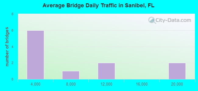
- 65,431Total average daily traffic
- 3,577Total average daily truck traffic
- National Bridge Inventory (NBI) Registered Bridges for Sanibel
- No street view available for this location
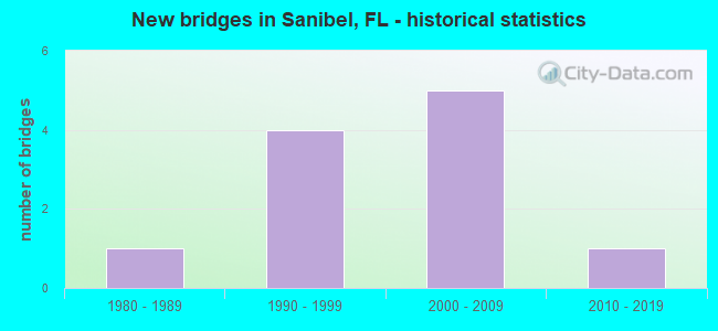
- New bridges - historical statistics
- 11980-1989
- 41990-1999
- 52000-2009
- 12010-2019
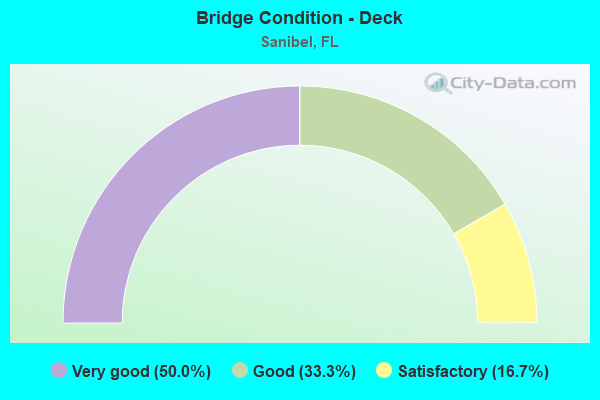
- Bridge Condition - Deck
- 50.0%Very good
- 33.3%Good
- 16.7%Satisfactory
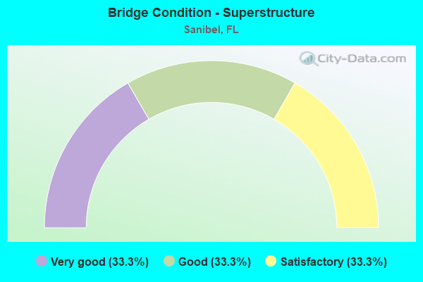
- Bridge Condition - Superstructure
- 33.3%Very good
- 33.3%Good
- 33.3%Satisfactory
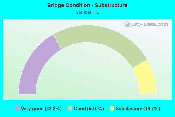
- Bridge Condition - Substructure
- 33.3%Very good
- 50.0%Good
- 16.7%Satisfactory
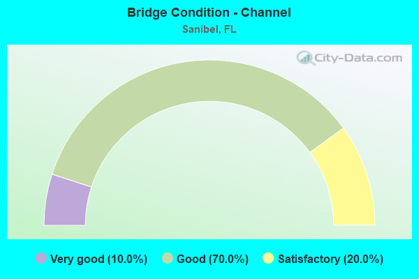
- Bridge Condition - Channel
- 10.0%Very good
- 70.0%Good
- 20.0%Satisfactory
Find on map >> Show street view
Structure Number: 124077, Location: 10MI N/O SANIBEL CAUSWAY (Lat: 26.482775, Lng: -82.182500), Route carried "on" structure: Other road , Year Built: 1990, Status: Open, Structure Length: 14.17m (46.49ft), Average Daily Traffic: 9,787 (year 2021), Truck Traffic: 5%, Average Future Daily Traffic: 10,276 (year 2041), Design Load: HS 20, Features Intersected: BLIND PASS, Facility Carried by Structure: SANIBEL-CAPTIVA RD
Minimum Vertical Clearance: 30+ m (98+ ft), Kilometerpoint: 20.255, Lanes on structure: 2, Owner: County Highway Agency, Approaching Roadway Width: 10.3m (33.8ft), Material/Design: Prestressed concrete, Design/Construction: Stringer/Multi-beam, Number Of Spans In Main Unit: 11, Length of Maximum Span: 13.1m (43.0ft), Curb or Sidewalk Widths: Left: 1.5m (4.9ft), Right: 1.5m (4.9ft), Curb-To-Curb Width: 10.3m (33.8ft), Out-to-Out Width: 14.9m (48.9ft)
Condition: Deck: Good, Superstructure: Satisfactory, Substructure: Good, Channel: Satisfactory, Operating Rating: 68.1 metric tons, Method Used To Determine Operating Rating: Load Factor (LF), Inventory Rating: 43.0 metric tons, Method Used To Determine Inventory Rating: Load Factor (LF), Structural Evaluation: Equal to present minimum criteria, Deck Geometry: Meets minimum limits, Waterway Adequacy: Equal to present desirable criteria, Approach Roadway Alignment: Meets minimum limits, Designated Inspection Frequency: Every 24 months, Underwater Inspection Frequency: Every 24 months, Inspection Date: March 2021, Underwater Inspection Date: Febuary 2021, Deck Structure Type: Concrete Cast-file-Place
Find on map >> Show street view
Structure Number: 124114, Location: 3RD STRUCT S OF TOLL PLAZ (Lat: 26.458836, Lng: -82.033967), Route carried "on" structure: County highway 867, Year Built: 2007, Status: Open, Structure Length: 117.85m (386.65ft), Average Daily Traffic: 19,690 (year 2021), Truck Traffic: 7%, Average Future Daily Traffic: 20,675 (year 2041), Design Load: HL 93, Features Intersected: SAN CARLOS BAY
Minimum Vertical Clearance: 30+ m (98+ ft), Kilometerpoint: 0.000, Lanes on structure: 2, Toll: On toll road, Owner: County Highway Agency, Approaching Roadway Width: 12.2m (40.0ft), Navigation Control: Yes ( Vertical Clearance: 7.9m (25.9ft), Horizontal Clearance: 29.3m (96.1ft)), Material/Design: Prestressed concrete, Design/Construction: Stringer/Multi-beam, Number Of Spans In Main Unit: 27, Length of Maximum Span: 43.9m (144.0ft), Curb-To-Curb Width: 12.2m (40.0ft), Out-to-Out Width: 13.1m (43.0ft)
Condition: Deck: Good, Superstructure: Good, Substructure: Good, Channel: Good, Inventory Rating: 53.7 metric tons, Method Used To Determine Inventory Rating: Load Factor (LF), Structural Evaluation: Better than present minimum criteria, Deck Geometry: Somewhat better than minimum adequacy, Waterway Adequacy: Equal to present desirable criteria, Approach Roadway Alignment: Equal to present desirable criteria, Designated Inspection Frequency: Every 24 months, Underwater Inspection Frequency: Every 24 months, Inspection Date: November 2021, Underwater Inspection Date: October 2021, Deck Structure Type: Concrete Cast-file-Place
Find on map >> Show street view
Structure Number: 124116, Location: 1ST STRUC S OF TOLL PLAZA (Lat: 26.482872, Lng: -82.014700), Route carried "on" structure: County highway 867, Year Built: 2007, Status: Open, Structure Length: 91.52m (300.26ft), Average Daily Traffic: 19,690 (year 2021), Truck Traffic: 7%, Average Future Daily Traffic: 20,675 (year 2041), Design Load: HL 93, Features Intersected: SAN CARLOS BAY
Minimum Vertical Clearance: 30+ m (98+ ft), Kilometerpoint: 3.642, Lanes on structure: 2, Lanes under structure: 1, Toll: On toll road, Owner: County Highway Agency, Approaching Roadway Width: 12.2m (40.0ft), Navigation Control: Yes ( Vertical Clearance: 21.3m (69.9ft), Horizontal Clearance: 33.9m (111.2ft)), Material/Design: Prestressed concrete continuous, Design/Construction: Stringer/Multi-beam, Number Of Spans In Main Unit: 21, Length of Maximum Span: 44.0m (144.4ft), Curb-To-Curb Width: 12.2m (40.0ft), Out-to-Out Width: 13.1m (43.0ft)
Condition: Deck: Very good, Superstructure: Good, Substructure: Good, Channel: Good, Operating Rating: 55.2 metric tons, Method Used To Determine Operating Rating: Load and Resistance Factor (LRFR), Inventory Rating: 43.3 metric tons, Method Used To Determine Inventory Rating: Load and Resistance Factor (LRFR), Structural Evaluation: Better than present minimum criteria, Deck Geometry: Somewhat better than minimum adequacy, Waterway Adequacy: Equal to present desirable criteria, Approach Roadway Alignment: Equal to present desirable criteria, Designated Inspection Frequency: Every 24 months, Underwater Inspection Frequency: Every 24 months, Inspection Date: November 2021, Underwater Inspection Date: October 2021, Deck Structure Type: Concrete Cast-file-Place
Find on map >> Show street view
Structure Number: 126502, Location: 1.1 MILE W OF BAILEY RD (Lat: 26.462628, Lng: -82.048983), Route carried "on" structure: City street , Year Built: 1988, Status: Open, Structure Length: 1.74m (5.71ft), Average Daily Traffic: 4 (year 2021), Average Future Daily Traffic: 6 (year 2041), Features Intersected: TIDAL CANAL, Facility Carried by Structure: BAY DRIVE
Minimum Vertical Clearance: 30+ m (98+ ft), Kilometerpoint: 0.000, Lanes on structure: 1, Owner: City or Municipal Highway Agency, Approaching Roadway Width: 3.7m (12.1ft), Material/Design: Concrete, Design/Construction: Frame, Number Of Spans In Main Unit: 5, Length of Maximum Span: 3.3m (10.8ft), Curb-To-Curb Width: 3.7m (12.1ft), Out-to-Out Width: 4.6m (15.1ft)
Condition: Deck: Satisfactory, Superstructure: Satisfactory, Substructure: Satisfactory, Channel: Satisfactory, Operating Rating: 46.9 metric tons, Method Used To Determine Operating Rating: Load Factor (LF), Inventory Rating: 28.0 metric tons, Method Used To Determine Inventory Rating: Load Factor (LF), Structural Evaluation: Equal to present minimum criteria, Deck Geometry: Meets minimum limits, Waterway Adequacy: Equal to present minimum criteria, Approach Roadway Alignment: Somewhat better than minimum adequacy, Designated Inspection Frequency: Every 24 months, Inspection Date: July 2021, Deck Structure Type: Concrete Precast Panels, Wearing Surface/Protective System: Wearing Surface: Wood or Timber
Find on map >> Show street view
Structure Number: 126503, Location: 0.5M W OF TARPON BAY RD (Lat: 26.438175, Lng: -82.088297), Route carried "on" structure: City street 867, Year Built: 1995, Status: Open, Structure Length: 1.30m (4.27ft), Average Daily Traffic: 8,630 (year 2021), Truck Traffic: 2%, Average Future Daily Traffic: 26,301 (year 2041), Design Load: HS 20+Mod, Features Intersected: SANIBEL RIVER, Facility Carried by Structure: SANIBEL CAPTIVA RD
Minimum Vertical Clearance: 30+ m (98+ ft), Kilometerpoint: 7.162, Lanes on structure: 2, Owner: City or Municipal Highway Agency, Approaching Roadway Width: 7.4m (24.3ft), Material/Design: Concrete, Design/Construction: Culvert, Number Of Spans In Main Unit: 4, Length of Maximum Span: 3.4m (11.2ft)
Condition: Channel: Good, Culverts: Good, Operating Rating: 65.0 metric tons, Method Used To Determine Operating Rating: Load Factor (LF), Inventory Rating: 39.0 metric tons, Method Used To Determine Inventory Rating: Load Factor (LF), Structural Evaluation: Better than present minimum criteria, Waterway Adequacy: Equal to present minimum criteria, Approach Roadway Alignment: Equal to present desirable criteria, Designated Inspection Frequency: Every 24 months, Underwater Inspection Frequency: Every 24 months, Inspection Date: July 2021, Underwater Inspection Date: June 2021
Find on map >> Show street view
Structure Number: 126504, Location: 0.3MI S OF SANIBEL CAP RD (Lat: 26.437594, Lng: -82.107981), Route carried "on" structure: City street , Year Built: 1995, Status: Open, Structure Length: 0.76m (2.49ft), Average Daily Traffic: 210 (year 2021), Truck Traffic: 1%, Average Future Daily Traffic: 640 (year 2041), Design Load: HS 20+Mod, Features Intersected: SANIBEL RIVER, Facility Carried by Structure: RABBIT ROAD
Minimum Vertical Clearance: 30+ m (98+ ft), Kilometerpoint: 0.810, Lanes on structure: 2, Owner: City or Municipal Highway Agency, Approaching Roadway Width: 6.4m (21.0ft), Material/Design: Concrete, Design/Construction: Culvert, Number Of Spans In Main Unit: 2, Length of Maximum Span: 3.7m (12.1ft)
Condition: Channel: Good, Culverts: Good, Inventory Rating: 55.8 metric tons, Method Used To Determine Inventory Rating: Load Factor (LF), Structural Evaluation: Better than present minimum criteria, Waterway Adequacy: Equal to present minimum criteria, Approach Roadway Alignment: Equal to present desirable criteria, Designated Inspection Frequency: Every 24 months, Underwater Inspection Frequency: Every 24 months, Inspection Date: July 2021, Underwater Inspection Date: June 2021
Find on map >> Show street view
Structure Number: 126505, Location: 0.2 MI S OF PERIWINKLE (Lat: 26.441586, Lng: -82.046492), Route carried "on" structure: City street , Year Built: 1995, Status: Open, Structure Length: 0.66m (2.17ft), Average Daily Traffic: 510 (year 2021), Truck Traffic: 2%, Average Future Daily Traffic: 612 (year 2041), Design Load: HS 20, Features Intersected: SANIBEL RIVER, Facility Carried by Structure: DONAX STREET
Minimum Vertical Clearance: 30+ m (98+ ft), Kilometerpoint: 0.562, Lanes on structure: 2, Owner: City or Municipal Highway Agency, Approaching Roadway Width: 7.1m (23.3ft), Material/Design: Concrete, Design/Construction: Culvert, Number Of Spans In Main Unit: 2, Length of Maximum Span: 3.3m (10.8ft)
Condition: Channel: Good, Culverts: Good, Operating Rating: 54.7 metric tons, Method Used To Determine Operating Rating: Load Factor (LF), Inventory Rating: 32.8 metric tons, Method Used To Determine Inventory Rating: Load Factor (LF), Structural Evaluation: Better than present minimum criteria, Waterway Adequacy: Equal to present minimum criteria, Approach Roadway Alignment: Equal to present desirable criteria, Designated Inspection Frequency: Every 24 months, Underwater Inspection Frequency: Every 24 months, Inspection Date: July 2021, Underwater Inspection Date: June 2021
Find on map >> Show street view
Structure Number: 126506, Location: 0.5MI W OF WULFERT RD. (Lat: 26.471806, Lng: -82.164617), Route carried "on" structure: City street , Year Built: 2008, Status: Open, Structure Length: 0.96m (3.15ft), Average Daily Traffic: 5,760 (year 2021), Truck Traffic: 2%, Average Future Daily Traffic: 6,912 (year 2041), Design Load: H 20, Features Intersected: CLAM-DINKINS BAYOU, Facility Carried by Structure: SANIBEL-CAPTIVA RD
Minimum Vertical Clearance: 30.18m (99.02ft), Kilometerpoint: 15.894, Lanes on structure: 2, Owner: City or Municipal Highway Agency, Approaching Roadway Width: 7.3m (24.0ft), Material/Design: Concrete, Design/Construction: Culvert, Number Of Spans In Main Unit: 3, Length of Maximum Span: 3.2m (10.5ft)
Condition: Channel: Good, Culverts: Good, Operating Rating: 39.6 metric tons, Method Used To Determine Operating Rating: Load Factor (LF), Inventory Rating: 23.7 metric tons, Method Used To Determine Inventory Rating: Load Factor (LF), Structural Evaluation: Somewhat better than minimum adequacy, Waterway Adequacy: Equal to present desirable criteria, Approach Roadway Alignment: Equal to present desirable criteria, Designated Inspection Frequency: Every 24 months, Underwater Inspection Frequency: Every 24 months, Inspection Date: July 2021, Underwater Inspection Date: June 2021
Find on map >> Show street view
Structure Number: 126507, Location: 0.3 MI S/O PERIWINKLE WAY (Lat: 26.443128, Lng: -82.038508), Route carried "on" structure: City street , Year Built: 2012, Status: Open, Structure Length: 0.73m (2.40ft), Average Daily Traffic: 340 (year 2021), Truck Traffic: 1%, Average Future Daily Traffic: 587 (year 2041), Design Load: HL 93, Features Intersected: SANIBEL RIVER, Facility Carried by Structure: LINDGREN BLVD
Minimum Vertical Clearance: 30+ m (98+ ft), Kilometerpoint: 0.312, Lanes on structure: 2, Owner: City or Municipal Highway Agency, Approaching Roadway Width: 8.0m (26.2ft), Material/Design: Concrete, Design/Construction: Slab, Number Of Spans In Main Unit: 1, Length of Maximum Span: 7.3m (24.0ft), Curb or Sidewalk Widths: Left: 2.7m (8.9ft), Right: 0.0m, Curb-To-Curb Width: 8.0m (26.2ft), Out-to-Out Width: 11.8m (38.7ft)
Condition: Deck: Very good, Superstructure: Very good, Substructure: Very good, Channel: Very good, Operating Rating: 35.1 metric tons, Method Used To Determine Operating Rating: Load and Resistance Factor (LRFR), Inventory Rating: 27.0 metric tons, Method Used To Determine Inventory Rating: Load and Resistance Factor (LRFR), Structural Evaluation: Equal to present minimum criteria, Deck Geometry: Somewhat better than minimum adequacy, Waterway Adequacy: Superior to present desirable criteria, Approach Roadway Alignment: Equal to present desirable criteria, Designated Inspection Frequency: Every 24 months, Underwater Inspection Frequency: Every 24 months, Inspection Date: July 2021, Underwater Inspection Date: June 2021, Deck Structure Type: Concrete Cast-file-Place
Find on map >> Show street view
Structure Number: 41540-00106, Location: SANIBEL ISLAND (Lat: 26.446000, Lng: -82.113500), Route carried "on" structure: Federal lands road , Year Built: 2002, Status: Open, Structure Length: 1.74m (5.71ft), Average Daily Traffic: 700 (year 2021), Truck Traffic: 4%, Average Future Daily Traffic: 900 (year 2041), Design Load: HS 20, Features Intersected: TIDAL BASIN, Facility Carried by Structure: WILDLIFE DRIVE
Minimum Vertical Clearance: 30.48m (100.00ft), Kilometerpoint: 0.080, Lanes on structure: 1, Owner: Bureau of Fish and Wildlife, Approaching Roadway Width: 4.6m (15.1ft), Material/Design: Prestressed concrete, Design/Construction: Slab, Number Of Spans In Main Unit: 1, Length of Maximum Span: 16.5m (54.1ft), Curb or Sidewalk Widths: Left: 1.0m (3.3ft), Right: 0.3m (1.0ft), Curb-To-Curb Width: 5.8m (19.0ft), Out-to-Out Width: 6.4m (21.0ft)
Condition: Deck: Very good, Superstructure: Very good, Substructure: Very good, Channel: Good, Operating Rating: 52.6 metric tons, Method Used To Determine Operating Rating: Load Factor (LF), Inventory Rating: 35.4 metric tons, Method Used To Determine Inventory Rating: Load Factor (LF), Structural Evaluation: Equal to present desirable criteria, Deck Geometry: High priority of replacement, Waterway Adequacy: Better than present minimum criteria, Approach Roadway Alignment: Better than present minimum criteria, Designated Inspection Frequency: Every 24 months, Inspection Date: April 2021, Deck Structure Type: Other, Wearing Surface/Protective System: Wearing Surface: Bituminous, Membrane: Preformed Fabric, Deck Protection: Epoxy Coated Reinforcing
Find on map >> Show street view
Structure Number: 124116, Location: 1ST STRUC S OF TOLL PLAZA (Lat: 26.482872, Lng: -82.014700), Route carried "under" structure: ServiceOther road , Year Built: 2007, Structure Length: 0. m, Average Daily Traffic: 110 (year 2021), Truck Traffic: 2%, Features Intersected: SAN CARLOS BAY, Facility Carried by Structure: CR-867
Minimum Vertical Clearance: 4.88m (16.01ft), Kilometerpoint: 0.000, Lanes on structure: 2, Lanes under structure: 1, Material/Design: Prestressed concrete continuous, Design/Construction: Stringer/Multi-beam, Length of Maximum Span: 44.0m (144.4ft)