Bridge Statistics for Sappington, Missouri (MO)
Condition, Traffic, Stress, Structural Evaluation, Project Costs
- National Bridge Inventory (NBI) Statistics
- 11Number of bridges
- 118ft / 35.8mTotal length
- 497,828Total average daily traffic
- 57,390Total average daily truck traffic
- National Bridge Inventory (NBI) Registered Bridges for Sappington
- No street view available for this location
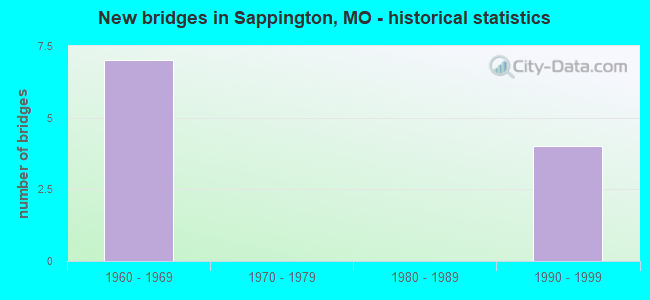
- New bridges - historical statistics
- 71960-1969
- 41990-1999
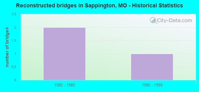
- Reconstructed bridges - Historical Statistics
- 21980-1989
- 11990-1999
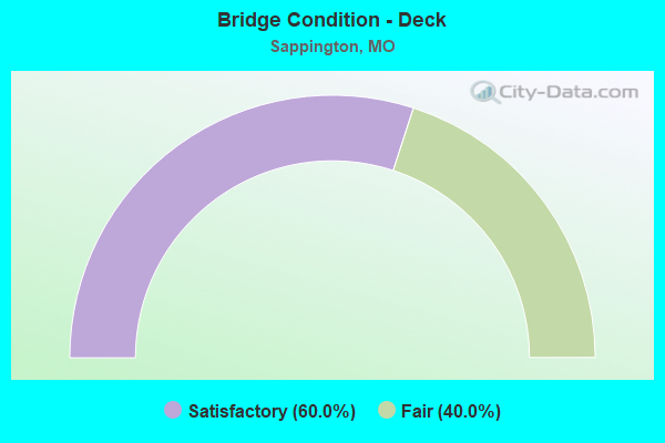
- Bridge Condition - Deck
- 60.0%Satisfactory
- 40.0%Fair
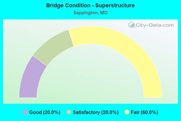
- Bridge Condition - Superstructure
- 20.0%Good
- 20.0%Satisfactory
- 60.0%Fair
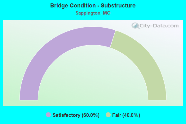
- Bridge Condition - Substructure
- 60.0%Satisfactory
- 40.0%Fair
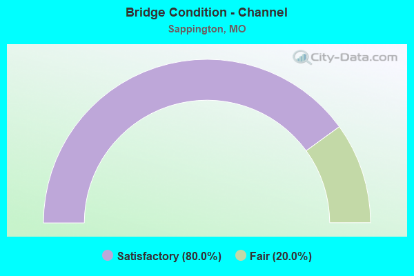
- Bridge Condition - Channel
- 80.0%Satisfactory
- 20.0%Fair
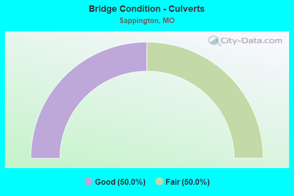
- Bridge Condition - Culverts
- 50.0%Good
- 50.0%Fair
Find on map >> Show street view
Structure Number: 15628, Location: S 20 T 44 N R 6 E (Lat: 38.538889, Lng: -90.366619), Route carried "on" structure: County highway , Year Built: 1965, Status: Posted for load, Structure Length: 1.19m (3.90ft), Average Daily Traffic: 913 (year 2020), Truck Traffic: 1%, Average Future Daily Traffic: 1,233 (year 2040), Features Intersected: SAPPINGTON CR, Facility Carried by Structure: BRIARSTONE DR
Minimum Vertical Clearance: 30+ m (98+ ft), Kilometerpoint: 0.161, Lanes on structure: 2, Owner: County Highway Agency, Approaching Roadway Width: 7.9m (25.9ft), Material/Design: Prestressed concrete, Design/Construction: Box Beam or Girders - Multiple, Number Of Spans In Main Unit: 1, Length of Maximum Span: 11.3m (37.1ft), Curb or Sidewalk Widths: Left: 0.9m (3.0ft), Right: 0.9m (3.0ft), Curb-To-Curb Width: 8.0m (26.2ft), Out-to-Out Width: 9.9m (32.5ft)
Condition: Deck: Fair, Superstructure: Fair, Substructure: Fair, Channel: Satisfactory, Operating Rating: 63.0 metric tons, Method Used To Determine Operating Rating: Allowable Stress (AS), Inventory Rating: 22.5 metric tons, Method Used To Determine Inventory Rating: Allowable Stress (AS), Structural Evaluation: Somewhat better than minimum adequacy, Deck Geometry: Somewhat better than minimum adequacy, Waterway Adequacy: Better than present minimum criteria, Approach Roadway Alignment: Equal to present minimum criteria, Designated Inspection Frequency: Every 24 months, Inspection Date: Febuary 2020, Deck Structure Type: Other, Wearing Surface/Protective System: Wearing Surface: Bituminous
Find on map >> Show street view
Structure Number: 28135, Location: S 29 T 44 N R 6 E (Lat: 38.515575, Lng: -90.375636), Route carried "on" structure: County highway , Year Built: 1996, Status: Posted for load, Structure Length: 0.85m (2.79ft), Average Daily Traffic: 808 (year 2020), Truck Traffic: 3%, Average Future Daily Traffic: 1,091 (year 2040), Design Load: HS 25 or greater, Features Intersected: BR OF MATTESE CR, Facility Carried by Structure: GREGORY CT
Minimum Vertical Clearance: 30+ m (98+ ft), Kilometerpoint: 0.000, Lanes on structure: 2, Owner: County Highway Agency, Approaching Roadway Width: 7.9m (25.9ft), Skew: 1 degrees, Material/Design: Concrete, Design/Construction: Culvert, Number Of Spans In Main Unit: 3, Length of Maximum Span: 2.4m (7.9ft)
Condition: Channel: Satisfactory, Culverts: Good, Operating Rating: 82.8 metric tons, Method Used To Determine Operating Rating: Load Factor (LF), Inventory Rating: 49.5 metric tons, Method Used To Determine Inventory Rating: Load Factor (LF), Structural Evaluation: Better than present minimum criteria, Waterway Adequacy: Superior to present desirable criteria, Approach Roadway Alignment: Equal to present desirable criteria, Designated Inspection Frequency: Every 24 months, Inspection Date: April 2021
Find on map >> Show street view
Structure Number: 4314, Location: S 3112 T 55 N R 6 E (Lat: 38.515522, Lng: -90.380247), Route carried "on" structure: County highway , Year Built: 1995, Status: Open, Structure Length: 8.44m (27.69ft), Average Daily Traffic: 11,280 (year 2021), Truck Traffic: 5%, Average Future Daily Traffic: 15,792 (year 2041), Design Load: HS 20, Features Intersected: IS 270, Facility Carried by Structure: SAPPINGTON RD S
Minimum Vertical Clearance: 30+ m (98+ ft), Kilometerpoint: 6.272, Lanes on structure: 3, Lanes under structure: 10, Owner: State Highway Agency, Approaching Roadway Width: 16.5m (54.1ft), Skew: 1 degrees, Material/Design: Steel continuous, Design/Construction: Stringer/Multi-beam, Number Of Spans In Main Unit: 2, Length of Maximum Span: 36.3m (119.1ft), Curb or Sidewalk Widths: Left: 1.7m (5.6ft), Right: 1.7m (5.6ft), Curb-To-Curb Width: 14.6m (47.9ft), Out-to-Out Width: 18.8m (61.7ft)
Condition: Deck: Satisfactory, Superstructure: Good, Substructure: Satisfactory, Operating Rating: 71.1 metric tons, Method Used To Determine Operating Rating: Load Factor (LF), Inventory Rating: 43.2 metric tons, Method Used To Determine Inventory Rating: Load Factor (LF), Structural Evaluation: Equal to present minimum criteria, Deck Geometry: Somewhat better than minimum adequacy, Underclear: High priority of corrective action, Approach Roadway Alignment: Equal to present desirable criteria, Designated Inspection Frequency: Every 24 months, Inspection Date: June 2020, Deck Structure Type: Concrete Cast-file-Place, Wearing Surface/Protective System: Wearing Surface: Monolithic Concrete, Deck Protection: Epoxy Coated Reinforcing
Find on map >> Show street view
Structure Number: 438, Location: S 26 T 44 N R 6 E (Lat: 38.523708, Lng: -90.320844), Route carried "on" structure: Interstate 55, Year Built: 1962, Year Reconstructed: 1987, Status: Open, Structure Length: 8.26m (27.10ft), Average Daily Traffic: 55,851 (year 2021), Truck Traffic: 18%, Average Future Daily Traffic: 69,814 (year 2041), Design Load: HS 20+Mod, Features Intersected: GRAVOIS CR
Minimum Vertical Clearance: 30+ m (98+ ft), Kilometerpoint: 17.724, Lanes on structure: 4, Base Highway Network: Yes, Owner: State Highway Agency, Approaching Roadway Width: 19.5m (64.0ft), Skew: 3 degrees, Material/Design: Steel continuous, Design/Construction: Stringer/Multi-beam, Number Of Spans In Main Unit: 5, Length of Maximum Span: 20.1m (65.9ft), Curb or Sidewalk Widths: Left: 0.2m (0.7ft), Right: 0.2m (0.7ft), Curb-To-Curb Width: 18.9m (62.0ft), Out-to-Out Width: 19.7m (64.6ft)
Condition: Deck: Satisfactory, Superstructure: Satisfactory, Substructure: Satisfactory, Channel: Fair, Operating Rating: 49.5 metric tons, Method Used To Determine Operating Rating: Load Factor (LF), Inventory Rating: 29.7 metric tons, Method Used To Determine Inventory Rating: Load Factor (LF), Structural Evaluation: Equal to present minimum criteria, Deck Geometry: Meets minimum limits, Waterway Adequacy: Equal to present desirable criteria, Approach Roadway Alignment: Equal to present desirable criteria, Designated Inspection Frequency: Every 24 months, Inspection Date: July 2020, Deck Structure Type: Concrete Cast-file-Place, Wearing Surface/Protective System: Wearing Surface: Low Slump Concrete
Find on map >> Show street view
Structure Number: 439, Location: S 26 T 44 N R 6 E (Lat: 38.523486, Lng: -90.320758), Route carried "on" structure: Interstate 55, Year Built: 1962, Year Reconstructed: 1987, Status: Open, Structure Length: 7.99m (26.21ft), Average Daily Traffic: 52,583 (year 2021), Truck Traffic: 12%, Average Future Daily Traffic: 65,729 (year 2041), Design Load: HS 20+Mod, Features Intersected: GRAVOIS CR
Minimum Vertical Clearance: 30+ m (98+ ft), Kilometerpoint: 319.835, Lanes on structure: 4, Base Highway Network: Yes, Owner: State Highway Agency, Approaching Roadway Width: 19.5m (64.0ft), Skew: 3 degrees, Material/Design: Steel continuous, Design/Construction: Stringer/Multi-beam, Number Of Spans In Main Unit: 5, Length of Maximum Span: 20.1m (65.9ft), Curb or Sidewalk Widths: Left: 0.2m (0.7ft), Right: 0.2m (0.7ft), Curb-To-Curb Width: 18.9m (62.0ft), Out-to-Out Width: 19.7m (64.6ft)
Condition: Deck: Fair, Superstructure: Fair, Substructure: Satisfactory, Channel: Satisfactory, Operating Rating: 49.5 metric tons, Method Used To Determine Operating Rating: Load Factor (LF), Inventory Rating: 29.7 metric tons, Method Used To Determine Inventory Rating: Load Factor (LF), Structural Evaluation: Somewhat better than minimum adequacy, Deck Geometry: Meets minimum limits, Waterway Adequacy: Equal to present desirable criteria, Approach Roadway Alignment: Equal to present desirable criteria, Designated Inspection Frequency: Every 24 months, Inspection Date: July 2020, Deck Structure Type: Concrete Cast-file-Place, Wearing Surface/Protective System: Wearing Surface: Low Slump Concrete
Find on map >> Show street view
Structure Number: 827, Location: S 3117 T 44 N R 6 E (Lat: 38.525161, Lng: -90.398667), Route carried "on" structure: State highway 30, Year Built: 1966, Year Reconstructed: 1996, Status: Posted for load, Structure Length: 8.11m (26.61ft), Average Daily Traffic: 37,363 (year 2021), Truck Traffic: 4%, Average Future Daily Traffic: 52,308 (year 2041), Design Load: HS 20, Features Intersected: IS 270
Minimum Vertical Clearance: 6.45m (21.16ft), Kilometerpoint: 65.692, Lanes on structure: 10, Lanes under structure: 8, Base Highway Network: Yes, Owner: State Highway Agency, Approaching Roadway Width: 41.5m (136.2ft), Skew: 23 degrees, Material/Design: Steel continuous, Design/Construction: Stringer/Multi-beam, Number Of Spans In Main Unit: 4, Length of Maximum Span: 23.5m (77.1ft), Curb-To-Curb Width: 44.5m (146.0ft), Out-to-Out Width: 45.3m (148.6ft)
Condition: Deck: Satisfactory, Superstructure: Fair, Substructure: Fair, Operating Rating: 51.3 metric tons, Method Used To Determine Operating Rating: Load Factor (LF), Inventory Rating: 30.6 metric tons, Method Used To Determine Inventory Rating: Load Factor (LF), Structural Evaluation: Somewhat better than minimum adequacy, Deck Geometry: Superior to present desirable criteria, Underclear: Meets minimum limits, Approach Roadway Alignment: Equal to present desirable criteria, Designated Inspection Frequency: Every 24 months, Inspection Date: June 2020, Deck Structure Type: Concrete Cast-file-Place, Wearing Surface/Protective System: Wearing Surface: Monolithic Concrete, Deck Protection: Epoxy Coated Reinforcing
Find on map >> Show street view
Structure Number: 956, Location: S 1988 T 44 N R 6 E (Lat: 38.514364, Lng: -90.369692), Route carried "on" structure: State highway 21, Year Built: 1967, Status: Open, Structure Length: 0.97m (3.18ft), Average Daily Traffic: 24,914 (year 2021), Truck Traffic: 5%, Average Future Daily Traffic: 34,880 (year 2041), Design Load: HS 20, Features Intersected: MATTESE CR
Minimum Vertical Clearance: 30+ m (98+ ft), Kilometerpoint: 5.607, Lanes on structure: 4, Base Highway Network: Yes, Owner: State Highway Agency, Approaching Roadway Width: 25.0m (82.0ft), Skew: 20 degrees, Material/Design: Concrete continuous, Design/Construction: Culvert, Number Of Spans In Main Unit: 3, Length of Maximum Span: 3.0m (9.8ft)
Condition: Channel: Satisfactory, Culverts: Fair, Operating Rating: 87.3 metric tons, Method Used To Determine Operating Rating: Field evaluation and documented engineering judgment, Inventory Rating: 52.2 metric tons, Method Used To Determine Inventory Rating: Field evaluation and documented engineering judgment, Structural Evaluation: Somewhat better than minimum adequacy, Waterway Adequacy: Equal to present desirable criteria, Approach Roadway Alignment: Equal to present desirable criteria, Designated Inspection Frequency: Every 24 months, Inspection Date: November 2021
Find on map >> Show street view
Structure Number: 4314, Location: S 3112 T 55 N R 6 E (Lat: 38.515522, Lng: -90.380247), Route carried "under" structure: Interstate 270, Year Built: 1995, Structure Length: 0. m, Average Daily Traffic: 72,813 (year 2021), Truck Traffic: 12%, Features Intersected: IS 270, Facility Carried by Structure: SAPPINGTON RD S
Minimum Vertical Clearance: 5.89m (19.32ft), Kilometerpoint: 53.297, Lanes on structure: 3, Lanes under structure: 5, Material/Design: Steel continuous, Design/Construction: Stringer/Multi-beam, Length of Maximum Span: 36.3m (119.1ft)
Find on map >> Show street view
Structure Number: 4314, Location: S 3112 T 55 N R 6 E (Lat: 38.515522, Lng: -90.380247), Route carried "under" structure: Interstate 270, Year Built: 1995, Structure Length: 0. m, Average Daily Traffic: 84,245 (year 2021), Truck Traffic: 12%, Features Intersected: IS 270, Facility Carried by Structure: SAPPINGTON RD S
Minimum Vertical Clearance: 5.18m (16.99ft), Kilometerpoint: 4.318, Lanes on structure: 3, Lanes under structure: 5, Material/Design: Steel continuous, Design/Construction: Stringer/Multi-beam, Length of Maximum Span: 36.3m (119.1ft)
Find on map >> Show street view
Structure Number: 827, Location: S 3117 T 44 N R 6 E (Lat: 38.525161, Lng: -90.398667), Route carried "under" structure: Interstate 270, Year Built: 1966, Structure Length: 0. m, Average Daily Traffic: 84,245 (year 2021), Truck Traffic: 12%, Features Intersected: IS 270, Facility Carried by Structure: MO 30 E
Minimum Vertical Clearance: 4.88m (16.01ft), Kilometerpoint: 6.268, Lanes on structure: 10, Lanes under structure: 4, Material/Design: Steel continuous, Design/Construction: Stringer/Multi-beam, Length of Maximum Span: 23.5m (77.1ft)
Find on map >> Show street view
Structure Number: 827, Location: S 3117 T 44 N R 6 E (Lat: 38.525161, Lng: -90.398667), Route carried "under" structure: Interstate 270, Year Built: 1966, Structure Length: 0. m, Average Daily Traffic: 72,813 (year 2021), Truck Traffic: 12%, Features Intersected: IS 270, Facility Carried by Structure: MO 30 E
Minimum Vertical Clearance: 4.83m (15.85ft), Kilometerpoint: 51.316, Lanes on structure: 10, Lanes under structure: 4, Material/Design: Steel continuous, Design/Construction: Stringer/Multi-beam, Length of Maximum Span: 23.5m (77.1ft)