Bridge Statistics for Saraland, Alabama (AL)
Condition, Traffic, Stress, Structural Evaluation, Project Costs
- National Bridge Inventory (NBI) Statistics
- 37Number of bridges
- 374ft / 114mTotal length
- $43,594,000Total costs
- 566,720Total average daily traffic
- 62,437Total average daily truck traffic
- National Bridge Inventory (NBI) Registered Bridges for Saraland
- No street view available for this location
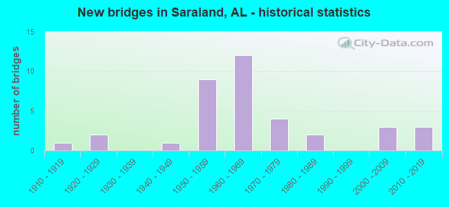
- New bridges - historical statistics
- 11910-1919
- 21920-1929
- 11940-1949
- 91950-1959
- 121960-1969
- 41970-1979
- 21980-1989
- 32000-2009
- 32010-2019
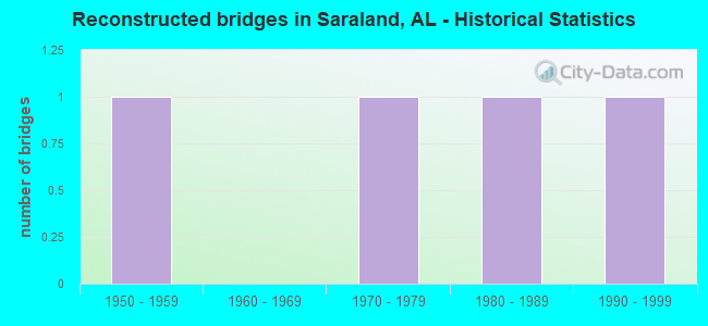
- Reconstructed bridges - Historical Statistics
- 11950-1959
- 01960-1969
- 11970-1979
- 11980-1989
- 11990-1999
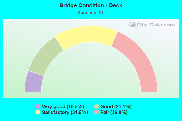
- Bridge Condition - Deck
- 10.5%Very good
- 21.1%Good
- 31.6%Satisfactory
- 36.8%Fair
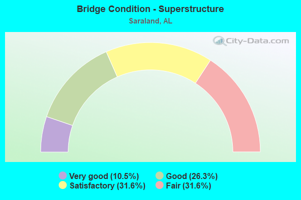
- Bridge Condition - Superstructure
- 10.5%Very good
- 26.3%Good
- 31.6%Satisfactory
- 31.6%Fair
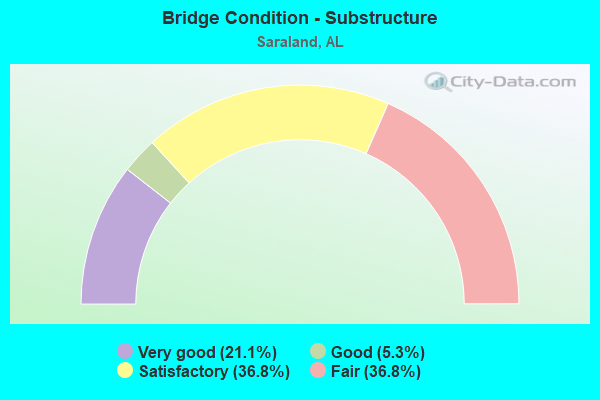
- Bridge Condition - Substructure
- 21.1%Very good
- 5.3%Good
- 36.8%Satisfactory
- 36.8%Fair
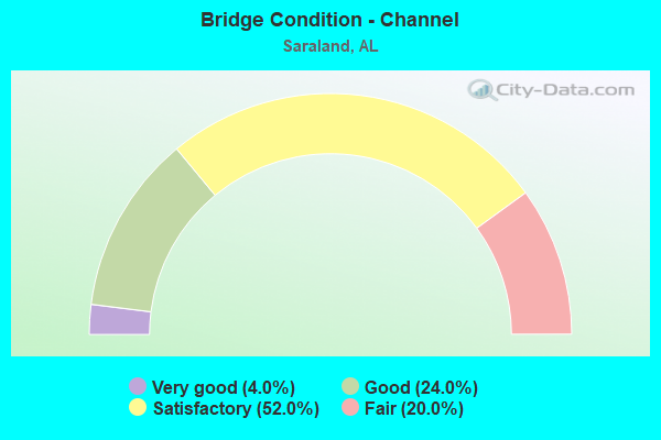
- Bridge Condition - Channel
- 4.0%Very good
- 24.0%Good
- 52.0%Satisfactory
- 20.0%Fair
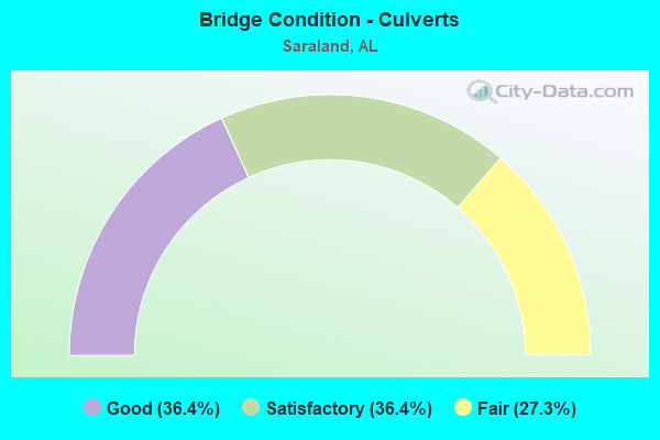
- Bridge Condition - Culverts
- 36.4%Good
- 36.4%Satisfactory
- 27.3%Fair
Find on map >> Show street view
Structure Number: 547, Location: 0.2 MI W JCT HWY 431 S (Lat: 34.546742, Lng: -86.432858), Route carried "on" structure: City street 155, Year Built: 1928, Status: Open, Structure Length: 1.01m (3.31ft), Average Daily Traffic: 4,060 (year 2006), Truck Traffic: 1%, Average Future Daily Traffic: 4,930 (year 2035), Design Load: H 10, Features Intersected: YELLOW BANK CREEK, Facility Carried by Structure: HOBBS ISLAND RD
Minimum Vertical Clearance: 30+ m (98+ ft), Kilometerpoint: 0.010, Lanes on structure: 2, Owner: City or Municipal Highway Agency, Approaching Roadway Width: 9.8m (32.2ft), Material/Design: Concrete, Design/Construction: Culvert, Number Of Spans In Main Unit: 3, Length of Maximum Span: 3.0m (9.8ft), Curb-To-Curb Width: 8.1m (26.6ft), Out-to-Out Width: 8.6m (28.2ft)
Condition: Channel: Satisfactory, Culverts: Good, Operating Rating: 74.1 metric tons, Method Used To Determine Operating Rating: Load Factor (LF), Inventory Rating: 44.5 metric tons, Method Used To Determine Inventory Rating: Load Factor (LF), Structural Evaluation: Better than present minimum criteria, Deck Geometry: High priority of corrective action, Waterway Adequacy: Equal to present minimum criteria, Approach Roadway Alignment: Better than present minimum criteria, Length Of Structure Improvement: 1.68m (5.51ft), Designated Inspection Frequency: Every 24 months, Inspection Date: October 2020, Bridge Improvement Cost: $272,000, Roadway Improvement Cost: $27,000, Total Project Cost: $299,000 ( Estimate for 2022)
Find on map >> Show street view
Structure Number: 585, Location: 2.8 MI EAST JCT US 431 (Lat: 33.635583, Lng: -85.677861), Route carried "on" structure: US 78, Year Built: 1929, Status: Open, Structure Length: 0.97m (3.18ft), Average Daily Traffic: 3,945 (year 2020), Truck Traffic: 9%, Average Future Daily Traffic: 5,523 (year 2040), Design Load: H 15, Features Intersected: EGONIAGA CREEK
Minimum Vertical Clearance: 30+ m (98+ ft), Kilometerpoint: 272.657, Lanes on structure: 2, Base Highway Network: Yes, Owner: State Highway Agency, Approaching Roadway Width: 8.5m (27.9ft), Material/Design: Concrete, Design/Construction: Culvert, Number Of Spans In Main Unit: 3, Length of Maximum Span: 3.1m (10.2ft)
Condition: Channel: Satisfactory, Culverts: Satisfactory, Operating Rating: 88.9 metric tons, Method Used To Determine Operating Rating: Load Factor (LF), Inventory Rating: 76.2 metric tons, Method Used To Determine Inventory Rating: Load Factor (LF), Structural Evaluation: Equal to present minimum criteria, Waterway Adequacy: Equal to present minimum criteria, Approach Roadway Alignment: Equal to present desirable criteria, Length Of Structure Improvement: 1.64m (5.38ft), Designated Inspection Frequency: Every 24 months, Inspection Date: August 2021, Bridge Improvement Cost: $313,000, Roadway Improvement Cost: $31,000, Total Project Cost: $344,000 ( Estimate for 2022)
Find on map >> Show street view
Structure Number: 3776, Location: 0.6 MI N CELESTE ROAD (Lat: 30.833333, Lng: -88.101667), Route carried "on" structure: City street , Year Built: 1950, Status: Open, Structure Length: 4.15m (13.62ft), Average Daily Traffic: 1,810 (year 2020), Truck Traffic: 1%, Average Future Daily Traffic: 2,600 (year 2040), Design Load: H 15, Features Intersected: BAYOU SARA, Facility Carried by Structure: FORREST AVE
Minimum Vertical Clearance: 30+ m (98+ ft), Kilometerpoint: 0.698, Lanes on structure: 2, Owner: City or Municipal Highway Agency, Approaching Roadway Width: 8.5m (27.9ft), Material/Design: Concrete, Design/Construction: Tee Beam, Number Of Spans In Main Unit: 4, Length of Maximum Span: 10.4m (34.1ft), Curb-To-Curb Width: 6.6m (21.7ft), Out-to-Out Width: 7.7m (25.3ft)
Condition: Deck: Good, Superstructure: Good, Substructure: Fair, Channel: Satisfactory, Operating Rating: 28.9 metric tons, Method Used To Determine Operating Rating: Load Factor (LF), Inventory Rating: 17.3 metric tons, Method Used To Determine Inventory Rating: Load Factor (LF), Structural Evaluation: Meets minimum limits, Deck Geometry: High priority of replacement, Waterway Adequacy: Equal to present minimum criteria, Approach Roadway Alignment: Somewhat better than minimum adequacy, Length Of Structure Improvement: 5.12m (16.80ft), Designated Inspection Frequency: Every 24 months, Other Special Inspection Frequency: Every 12 months, Inspection Date: October 2020, Other Special Inspection Date: October 2021, Bridge Improvement Cost: $877,000, Roadway Improvement Cost: $88,000, Total Project Cost: $965,000 ( Estimate for 2022), Deck Structure Type: Concrete Cast-file-Place
Find on map >> Show street view
Structure Number: 5305, Location: KENNELWORTH ST * PRIMROSE (Lat: 33.469381, Lng: -86.804061), Route carried "on" structure: City street , Year Built: 1955, Status: Open, Structure Length: 0.64m (2.10ft), Average Daily Traffic: 2,207 (year 2020), Truck Traffic: 1%, Average Future Daily Traffic: 3,734 (year 2040), Design Load: H 15, Features Intersected: GRIFFIN BROOK, Facility Carried by Structure: KENNELWORTH ST
Minimum Vertical Clearance: 30+ m (98+ ft), Kilometerpoint: 0.698, Lanes on structure: 2, Owner: City or Municipal Highway Agency, Approaching Roadway Width: 19.5m (64.0ft), Skew: 3 degrees, Material/Design: Concrete, Design/Construction: Slab, Number Of Spans In Main Unit: 1, Length of Maximum Span: 6.4m (21.0ft), Curb-To-Curb Width: 18.0m (59.1ft), Out-to-Out Width: 18.6m (61.0ft)
Condition: Deck: Good, Superstructure: Good, Substructure: Good, Channel: Good, Operating Rating: 43.5 metric tons, Method Used To Determine Operating Rating: Field evaluation and documented engineering judgment, Inventory Rating: 32.7 metric tons, Method Used To Determine Inventory Rating: Field evaluation and documented engineering judgment, Structural Evaluation: Better than present minimum criteria, Deck Geometry: Superior to present desirable criteria, Waterway Adequacy: Better than present minimum criteria, Approach Roadway Alignment: Equal to present desirable criteria, Length Of Structure Improvement: 1.26m (4.13ft), Designated Inspection Frequency: Every 24 months, Inspection Date: September 2020, Bridge Improvement Cost: $527,000, Roadway Improvement Cost: $53,000, Total Project Cost: $580,000 ( Estimate for 2022), Deck Structure Type: Concrete Cast-file-Place, Wearing Surface/Protective System: Wearing Surface: Bituminous
Find on map >> Show street view
Structure Number: 5382, Location: 2 MILES SE ST RD OF129 (Lat: 34.018333, Lng: -87.718083), Route carried "on" structure: County highway 24, Year Built: 1919, Year Reconstructed: 1956, Status: Open, Structure Length: 0.67m (2.20ft), Average Daily Traffic: 275 (year 2001), Truck Traffic: 25%, Average Future Daily Traffic: 650 (year 2036), Design Load: H 15, Features Intersected: NE FORK LITTLE NEW RIVER
Minimum Vertical Clearance: 30+ m (98+ ft), Kilometerpoint: 0.010, Lanes on structure: 2, Owner: County Highway Agency, Approaching Roadway Width: 7.3m (24.0ft), Material/Design: Concrete, Design/Construction: Culvert, Number Of Spans In Main Unit: 2, Length of Maximum Span: 3.0m (9.8ft), Curb-To-Curb Width: 6.7m (22.0ft), Out-to-Out Width: 7.0m (23.0ft)
Condition: Channel: Very good, Culverts: Satisfactory, Operating Rating: 50.1 metric tons, Method Used To Determine Operating Rating: Load Factor (LF), Inventory Rating: 30.0 metric tons, Method Used To Determine Inventory Rating: Load Factor (LF), Structural Evaluation: Equal to present minimum criteria, Deck Geometry: Meets minimum limits, Waterway Adequacy: Better than present minimum criteria, Approach Roadway Alignment: Better than present minimum criteria, Length Of Structure Improvement: 1.30m (4.27ft), Designated Inspection Frequency: Every 24 months, Inspection Date: Febuary 2022, Bridge Improvement Cost: $210,000, Roadway Improvement Cost: $21,000, Total Project Cost: $231,000 ( Estimate for 2022)
Find on map >> Show street view
Structure Number: 5468, Location: 1 MI NORTH OF CO RD16 (Lat: 32.103419, Lng: -86.843686), Route carried "on" structure: County highway 7, Year Built: 1956, Status: Open, Structure Length: 1.19m (3.90ft), Average Daily Traffic: 710 (year 2003), Truck Traffic: 5%, Average Future Daily Traffic: 850 (year 2028), Design Load: H 15, Features Intersected: CREEK
Minimum Vertical Clearance: 30+ m (98+ ft), Kilometerpoint: 0.010, Lanes on structure: 2, Base Highway Network: Yes, Owner: County Highway Agency, Approaching Roadway Width: 7.3m (24.0ft), Material/Design: Concrete, Design/Construction: Culvert, Number Of Spans In Main Unit: 3, Length of Maximum Span: 3.7m (12.1ft)
Condition: Channel: Satisfactory, Culverts: Good, Operating Rating: 55.7 metric tons, Method Used To Determine Operating Rating: Load Factor (LF), Inventory Rating: 33.4 metric tons, Method Used To Determine Inventory Rating: Load Factor (LF), Structural Evaluation: Better than present minimum criteria, Waterway Adequacy: Better than present minimum criteria, Approach Roadway Alignment: Equal to present desirable criteria, Length Of Structure Improvement: 1.86m (6.10ft), Designated Inspection Frequency: Every 24 months, Inspection Date: Febuary 2021, Bridge Improvement Cost: $366,000, Roadway Improvement Cost: $37,000, Total Project Cost: $403,000 ( Estimate for 2022)
Find on map >> Show street view
Structure Number: 5469, Location: 4 MI NORTH OF AL 21 (Lat: 32.106783, Lng: -86.845231), Route carried "on" structure: County highway 7, Year Built: 1956, Status: Posted for load, Structure Length: 3.11m (10.20ft), Average Daily Traffic: 710 (year 2015), Truck Traffic: 5%, Average Future Daily Traffic: 850 (year 2035), Design Load: H 15, Features Intersected: GREEN BRANCH
Minimum Vertical Clearance: 30+ m (98+ ft), Kilometerpoint: 0.010, Lanes on structure: 2, Base Highway Network: Yes, Owner: County Highway Agency, Approaching Roadway Width: 7.3m (24.0ft), Material/Design: Concrete, Design/Construction: Tee Beam, Number Of Spans In Main Unit: 3, Length of Maximum Span: 10.4m (34.1ft), Curb-To-Curb Width: 6.6m (21.7ft), Out-to-Out Width: 7.1m (23.3ft)
Condition: Deck: Fair, Superstructure: Fair, Substructure: Fair, Channel: Good, Operating Rating: 35.7 metric tons, Method Used To Determine Operating Rating: Load Factor (LF), Inventory Rating: 21.4 metric tons, Method Used To Determine Inventory Rating: Load Factor (LF), Structural Evaluation: Somewhat better than minimum adequacy, Deck Geometry: High priority of corrective action, Waterway Adequacy: Equal to present minimum criteria, Approach Roadway Alignment: Better than present minimum criteria, Bridge Posting: Required (Relationship of Operating Rating to Maximum Legal Load: 0.1 - 9.9% below), Length Of Structure Improvement: 3.96m (12.99ft), Designated Inspection Frequency: Every 24 months, Other Special Inspection Frequency: Every 12 months, Inspection Date: April 2021, Other Special Inspection Date: April 2021, Bridge Improvement Cost: $625,000, Roadway Improvement Cost: $63,000, Total Project Cost: $688,000 ( Estimate for 2022), Deck Structure Type: Concrete Cast-file-Place
Find on map >> Show street view
Structure Number: 5471, Location: 2 MI SOUTH OF CO RD12 (Lat: 32.132578, Lng: -86.883586), Route carried "on" structure: County highway 7, Year Built: 1956, Status: Open, Structure Length: 0.67m (2.20ft), Average Daily Traffic: 710 (year 2003), Truck Traffic: 5%, Average Future Daily Traffic: 850 (year 2028), Design Load: H 15, Features Intersected: CREEK
Minimum Vertical Clearance: 30+ m (98+ ft), Kilometerpoint: 0.010, Lanes on structure: 2, Base Highway Network: Yes, Owner: County Highway Agency, Approaching Roadway Width: 7.3m (24.0ft), Material/Design: Concrete, Design/Construction: Culvert, Number Of Spans In Main Unit: 2, Length of Maximum Span: 3.0m (9.8ft)
Condition: Channel: Satisfactory, Culverts: Good, Operating Rating: 88.9 metric tons, Method Used To Determine Operating Rating: Load Factor (LF), Inventory Rating: 76.1 metric tons, Method Used To Determine Inventory Rating: Load Factor (LF), Structural Evaluation: Better than present minimum criteria, Waterway Adequacy: Equal to present minimum criteria, Approach Roadway Alignment: Equal to present minimum criteria, Length Of Structure Improvement: 1.30m (4.27ft), Designated Inspection Frequency: Every 24 months, Inspection Date: Febuary 2021, Bridge Improvement Cost: $330,000, Roadway Improvement Cost: $33,000, Total Project Cost: $363,000 ( Estimate for 2022)
Find on map >> Show street view
Structure Number: 5475, Location: VIDA-JCT (Lat: 32.574256, Lng: -86.681825), Route carried "on" structure: County highway 19, Year Built: 1956, Status: Open, Structure Length: 0.70m (2.30ft), Average Daily Traffic: 611 (year 2002), Truck Traffic: 15%, Average Future Daily Traffic: 1,113 (year 2030), Design Load: H 10, Features Intersected: WYATT-BRANCH-VIDA-JCT.
Minimum Vertical Clearance: 30+ m (98+ ft), Kilometerpoint: 0.010, Lanes on structure: 2, Owner: County Highway Agency, Approaching Roadway Width: 8.5m (27.9ft), Material/Design: Concrete, Design/Construction: Culvert, Number Of Spans In Main Unit: 2, Length of Maximum Span: 3.0m (9.8ft), Out-to-Out Width: 11.0m (36.1ft)
Condition: Channel: Satisfactory, Culverts: Good, Operating Rating: 76.0 metric tons, Method Used To Determine Operating Rating: Load Factor (LF), Inventory Rating: 45.6 metric tons, Method Used To Determine Inventory Rating: Load Factor (LF), Structural Evaluation: Better than present minimum criteria, Waterway Adequacy: Equal to present desirable criteria, Approach Roadway Alignment: Better than present minimum criteria, Length Of Structure Improvement: 1.33m (4.36ft), Designated Inspection Frequency: Every 24 months, Inspection Date: November 2020, Bridge Improvement Cost: $539,000, Roadway Improvement Cost: $54,000, Total Project Cost: $593,000 ( Estimate for 2022)
Find on map >> Show street view
Structure Number: 585, Location: 0.6 MI S JCT SR 213 (Lat: 30.816153, Lng: -88.071097), Route carried "on" structure: US 43, Year Built: 1957, Status: Open, Structure Length: 1.89m (6.20ft), Average Daily Traffic: 19,439 (year 2018), Truck Traffic: 7%, Average Future Daily Traffic: 29,159 (year 2038), Design Load: HS 20, Features Intersected: NORTON CREEK
Minimum Vertical Clearance: 30+ m (98+ ft), Kilometerpoint: 9.658, Lanes on structure: 5, Owner: State Highway Agency, Approaching Roadway Width: 20.8m (68.2ft), Skew: 20 degrees, Material/Design: Concrete, Design/Construction: Culvert, Number Of Spans In Main Unit: 5, Length of Maximum Span: 3.7m (12.1ft)
Condition: Channel: Fair, Culverts: Fair, Operating Rating: 41.5 metric tons, Method Used To Determine Operating Rating: Load Factor (LF), Inventory Rating: 24.9 metric tons, Method Used To Determine Inventory Rating: Load Factor (LF), Structural Evaluation: Somewhat better than minimum adequacy, Waterway Adequacy: Equal to present minimum criteria, Approach Roadway Alignment: Better than present minimum criteria, Length Of Structure Improvement: 2.62m (8.60ft), Designated Inspection Frequency: Every 24 months, Inspection Date: July 2020, Bridge Improvement Cost: $1,375,000, Roadway Improvement Cost: $138,000, Total Project Cost: $1,513,000 ( Estimate for 2022)
Find on map >> Show street view
Structure Number: 5851, Location: JCT SR 213 (Lat: 30.824850, Lng: -88.069883), Route carried "on" structure: US 43, Year Built: 1957, Status: Open, Structure Length: 5.49m (18.01ft), Average Daily Traffic: 11,625 (year 2018), Truck Traffic: 5%, Average Future Daily Traffic: 17,438 (year 2038), Design Load: H 20, Features Intersected: BAYOU SARA
Minimum Vertical Clearance: 30+ m (98+ ft), Kilometerpoint: 10.627, Lanes on structure: 2, Owner: State Highway Agency, Approaching Roadway Width: 12.2m (40.0ft), Skew: 10 degrees, Material/Design: Concrete, Design/Construction: Tee Beam, Number Of Spans In Main Unit: 5, Length of Maximum Span: 11.0m (36.1ft), Curb-To-Curb Width: 8.5m (27.9ft), Out-to-Out Width: 10.2m (33.5ft)
Condition: Deck: Fair, Superstructure: Fair, Substructure: Fair, Channel: Satisfactory, Operating Rating: 42.0 metric tons, Method Used To Determine Operating Rating: Load Factor (LF), Inventory Rating: 25.2 metric tons, Method Used To Determine Inventory Rating: Load Factor (LF), Structural Evaluation: Somewhat better than minimum adequacy, Deck Geometry: High priority of corrective action, Waterway Adequacy: Equal to present minimum criteria, Approach Roadway Alignment: Equal to present minimum criteria, Length Of Structure Improvement: 6.52m (21.39ft), Designated Inspection Frequency: Every 24 months, Underwater Inspection Frequency: Every 24 months, Inspection Date: July 2020, Underwater Inspection Date: December 2020, Bridge Improvement Cost: $1,475,000, Roadway Improvement Cost: $148,000, Total Project Cost: $1,623,000 ( Estimate for 2022), Deck Structure Type: Concrete Cast-file-Place
Find on map >> Show street view
Structure Number: 5852, Location: JCT SR 213 (Lat: 30.824833, Lng: -88.069753), Route carried "on" structure: US 43, Year Built: 1957, Status: Open, Structure Length: 5.49m (18.01ft), Average Daily Traffic: 11,625 (year 2018), Truck Traffic: 7%, Average Future Daily Traffic: 17,438 (year 2038), Design Load: H 20, Features Intersected: BAYOU SARA
Minimum Vertical Clearance: 30+ m (98+ ft), Kilometerpoint: 10.627, Lanes on structure: 2, Owner: State Highway Agency, Approaching Roadway Width: 12.2m (40.0ft), Skew: 10 degrees, Material/Design: Concrete, Design/Construction: Tee Beam, Number Of Spans In Main Unit: 5, Length of Maximum Span: 11.0m (36.1ft), Curb-To-Curb Width: 8.5m (27.9ft), Out-to-Out Width: 10.2m (33.5ft)
Condition: Deck: Fair, Superstructure: Fair, Substructure: Fair, Channel: Satisfactory, Operating Rating: 40.7 metric tons, Method Used To Determine Operating Rating: Load Factor (LF), Inventory Rating: 24.4 metric tons, Method Used To Determine Inventory Rating: Load Factor (LF), Structural Evaluation: Somewhat better than minimum adequacy, Deck Geometry: High priority of corrective action, Waterway Adequacy: Equal to present minimum criteria, Approach Roadway Alignment: Equal to present minimum criteria, Length Of Structure Improvement: 6.52m (21.39ft), Designated Inspection Frequency: Every 24 months, Underwater Inspection Frequency: Every 24 months, Inspection Date: July 2020, Underwater Inspection Date: December 2020, Bridge Improvement Cost: $1,475,000, Roadway Improvement Cost: $148,000, Total Project Cost: $1,623,000 ( Estimate for 2022), Deck Structure Type: Concrete Cast-file-Place
Find on map >> Show street view
Structure Number: 7588, Location: 0.9 MI N E HWY 45 (Lat: 30.854069, Lng: -88.182647), Route carried "on" structure: County highway , Year Built: 1962, Status: Open, Structure Length: 7.27m (23.85ft), Average Daily Traffic: 371 (year 2020), Truck Traffic: 3%, Average Future Daily Traffic: 551 (year 2040), Design Load: H 20, Features Intersected: WILLIAMS CREEK, Facility Carried by Structure: KALI-OKA RD
Minimum Vertical Clearance: 30+ m (98+ ft), Kilometerpoint: 0.900, Lanes on structure: 2, Owner: County Highway Agency, Approaching Roadway Width: 7.3m (24.0ft), Material/Design: Concrete, Design/Construction: Tee Beam, Number Of Spans In Main Unit: 7, Length of Maximum Span: 10.4m (34.1ft), Curb or Sidewalk Widths: Left: 0.5m (1.6ft), Right: 0.5m (1.6ft), Curb-To-Curb Width: 7.3m (24.0ft), Out-to-Out Width: 8.9m (29.2ft)
Condition: Deck: Satisfactory, Superstructure: Satisfactory, Substructure: Satisfactory, Channel: Fair, Operating Rating: 46.7 metric tons, Method Used To Determine Operating Rating: Load Factor (LF), Inventory Rating: 28.0 metric tons, Method Used To Determine Inventory Rating: Load Factor (LF), Structural Evaluation: Equal to present minimum criteria, Deck Geometry: Somewhat better than minimum adequacy, Waterway Adequacy: Better than present minimum criteria, Approach Roadway Alignment: Better than present minimum criteria, Length Of Structure Improvement: 8.30m (27.23ft), Designated Inspection Frequency: Every 24 months, Inspection Date: October 2020, Bridge Improvement Cost: $1,650,000, Roadway Improvement Cost: $165,000, Total Project Cost: $1,815,000 ( Estimate for 2022), Deck Structure Type: Concrete Cast-file-Place
Find on map >> Show street view
Structure Number: 7589, Location: 1.2 MI N US 45 (Lat: 30.857778, Lng: -88.180689), Route carried "on" structure: County highway , Year Built: 1962, Status: Open, Structure Length: 12.47m (40.91ft), Average Daily Traffic: 449 (year 2020), Truck Traffic: 5%, Average Future Daily Traffic: 667 (year 2040), Design Load: H 20, Features Intersected: CHICKASAWBOGUE CREEK, Facility Carried by Structure: KALI-OKA RD
Minimum Vertical Clearance: 30+ m (98+ ft), Kilometerpoint: 1.199, Lanes on structure: 2, Owner: County Highway Agency, Approaching Roadway Width: 6.6m (21.7ft), Material/Design: Concrete, Design/Construction: Tee Beam, Number Of Spans In Main Unit: 12, Length of Maximum Span: 10.4m (34.1ft), Curb-To-Curb Width: 7.3m (24.0ft), Out-to-Out Width: 8.9m (29.2ft)
Condition: Deck: Satisfactory, Superstructure: Good, Substructure: Satisfactory, Channel: Satisfactory, Operating Rating: 43.5 metric tons, Method Used To Determine Operating Rating: Load Factor (LF), Inventory Rating: 26.1 metric tons, Method Used To Determine Inventory Rating: Load Factor (LF), Structural Evaluation: Equal to present minimum criteria, Deck Geometry: Meets minimum limits, Waterway Adequacy: Better than present minimum criteria, Approach Roadway Alignment: Equal to present minimum criteria, Length Of Structure Improvement: 13.31m (43.67ft), Designated Inspection Frequency: Every 24 months, Underwater Inspection Frequency: Every 24 months, Inspection Date: October 2020, Underwater Inspection Date: October 2020, Bridge Improvement Cost: $2,646,000, Roadway Improvement Cost: $265,000, Total Project Cost: $2,911,000 ( Estimate for 2022), Deck Structure Type: Concrete Cast-file-Place
Find on map >> Show street view
Structure Number: 9, Location: 0.9 MI N SR 158 (Lat: 30.814261, Lng: -88.100678), Route carried "on" structure: Interstate 65, Year Built: 1966, Status: Open, Structure Length: 1.71m (5.61ft), Average Daily Traffic: 51,074 (year 2018), Truck Traffic: 14%, Average Future Daily Traffic: 76,611 (year 2038), Design Load: HS 20, Features Intersected: MIDDLE NORTON BRANCH
Minimum Vertical Clearance: 30+ m (98+ ft), Kilometerpoint: 21.704, Lanes on structure: 4, Base Highway Network: Yes, Owner: State Highway Agency, Approaching Roadway Width: 34.4m (112.9ft), Skew: 13 degrees, Material/Design: Concrete, Design/Construction: Culvert, Number Of Spans In Main Unit: 4, Length of Maximum Span: 3.7m (12.1ft)
Condition: Channel: Satisfactory, Culverts: Fair, Operating Rating: 88.9 metric tons, Method Used To Determine Operating Rating: Load Factor (LF), Inventory Rating: 88.9 metric tons, Method Used To Determine Inventory Rating: Load Factor (LF), Structural Evaluation: Somewhat better than minimum adequacy, Waterway Adequacy: Equal to present minimum criteria, Approach Roadway Alignment: Equal to present desirable criteria, Length Of Structure Improvement: 2.40m (7.87ft), Designated Inspection Frequency: Every 24 months, Inspection Date: March 2020, Bridge Improvement Cost: $2,497,000, Roadway Improvement Cost: $250,000, Total Project Cost: $2,747,000 ( Estimate for 2022)
Find on map >> Show street view
Structure Number: 9267, Location: I-65 @ SR 158 * SR 213 (Lat: 30.801744, Lng: -88.104550), Route carried "on" structure: Interstate 65, Year Built: 1967, Status: Open, Structure Length: 7.53m (24.70ft), Average Daily Traffic: 35,559 (year 2018), Truck Traffic: 11%, Average Future Daily Traffic: 53,339 (year 2038), Design Load: HS 20, Features Intersected: SR 158 * SR 213
Minimum Vertical Clearance: 30+ m (98+ ft), Kilometerpoint: 20.991, Lanes on structure: 2, Lanes under structure: 16, Base Highway Network: Yes, Owner: State Highway Agency, Approaching Roadway Width: 8.5m (27.9ft), Skew: 10 degrees, Material/Design: Steel, Design/Construction: Stringer/Multi-beam, Number Of Spans In Main Unit: 4, Length of Maximum Span: 18.9m (62.0ft), Curb-To-Curb Width: 8.5m (27.9ft), Out-to-Out Width: 10.2m (33.5ft)
Condition: Deck: Fair, Superstructure: Fair, Substructure: Satisfactory, Operating Rating: 56.0 metric tons, Method Used To Determine Operating Rating: Allowable Stress (AS), Inventory Rating: 33.9 metric tons, Method Used To Determine Inventory Rating: Allowable Stress (AS), Structural Evaluation: Somewhat better than minimum adequacy, Deck Geometry: High priority of corrective action, Underclear: Meets minimum limits, Approach Roadway Alignment: Better than present minimum criteria, Length Of Structure Improvement: 8.55m (28.05ft), Designated Inspection Frequency: Every 24 months, Inspection Date: June 2020, Bridge Improvement Cost: $1,935,000, Roadway Improvement Cost: $194,000, Total Project Cost: $2,129,000 ( Estimate for 2022), Deck Structure Type: Concrete Cast-file-Place
Find on map >> Show street view
Structure Number: 9268, Location: I-65 @ SR 158 * SR 213 (Lat: 30.801833, Lng: -88.104308), Route carried "on" structure: Interstate 65, Year Built: 1967, Status: Open, Structure Length: 7.53m (24.70ft), Average Daily Traffic: 35,559 (year 2018), Truck Traffic: 11%, Average Future Daily Traffic: 53,339 (year 2038), Design Load: HS 20, Features Intersected: SR 158 * SR 213
Minimum Vertical Clearance: 30+ m (98+ ft), Kilometerpoint: 20.991, Lanes on structure: 2, Lanes under structure: 12, Base Highway Network: Yes, Owner: State Highway Agency, Approaching Roadway Width: 8.5m (27.9ft), Skew: 10 degrees, Material/Design: Steel, Design/Construction: Stringer/Multi-beam, Number Of Spans In Main Unit: 4, Length of Maximum Span: 18.9m (62.0ft), Curb-To-Curb Width: 8.5m (27.9ft), Out-to-Out Width: 10.2m (33.5ft)
Condition: Deck: Fair, Superstructure: Fair, Substructure: Satisfactory, Operating Rating: 56.0 metric tons, Method Used To Determine Operating Rating: Allowable Stress (AS), Inventory Rating: 33.9 metric tons, Method Used To Determine Inventory Rating: Allowable Stress (AS), Structural Evaluation: Somewhat better than minimum adequacy, Deck Geometry: High priority of corrective action, Underclear: Meets minimum limits, Approach Roadway Alignment: Better than present minimum criteria, Length Of Structure Improvement: 8.55m (28.05ft), Designated Inspection Frequency: Every 24 months, Inspection Date: June 2020, Bridge Improvement Cost: $1,935,000, Roadway Improvement Cost: $194,000, Total Project Cost: $2,129,000 ( Estimate for 2022), Deck Structure Type: Concrete Cast-file-Place
Find on map >> Show street view
Structure Number: 9271, Location: 0.3 MI N CELESTE ROAD (Lat: 30.832953, Lng: -88.086392), Route carried "on" structure: Interstate 65, Year Built: 1967, Status: Open, Structure Length: 2.38m (7.81ft), Average Daily Traffic: 51,074 (year 2018), Truck Traffic: 10%, Average Future Daily Traffic: 76,611 (year 2038), Design Load: HS 20, Features Intersected: BAYOU SARA CREEK
Minimum Vertical Clearance: 30+ m (98+ ft), Kilometerpoint: 24.900, Lanes on structure: 4, Base Highway Network: Yes, Owner: State Highway Agency, Approaching Roadway Width: 36.0m (118.1ft), Skew: 10 degrees, Material/Design: Concrete, Design/Construction: Culvert, Number Of Spans In Main Unit: 5, Length of Maximum Span: 4.6m (15.1ft)
Condition: Channel: Fair, Culverts: Fair, Operating Rating: 43.5 metric tons, Method Used To Determine Operating Rating: Field evaluation and documented engineering judgment, Inventory Rating: 32.7 metric tons, Method Used To Determine Inventory Rating: Field evaluation and documented engineering judgment, Structural Evaluation: Somewhat better than minimum adequacy, Waterway Adequacy: Equal to present minimum criteria, Approach Roadway Alignment: Equal to present desirable criteria, Length Of Structure Improvement: 3.23m (10.60ft), Designated Inspection Frequency: Every 24 months, Inspection Date: March 2020, Bridge Improvement Cost: $3,135,000, Roadway Improvement Cost: $314,000, Total Project Cost: $3,449,000 ( Estimate for 2022)
Find on map >> Show street view
Structure Number: 9273, Location: 3.61 MI N SR 158 (Lat: 30.847911, Lng: -88.076606), Route carried "on" structure: City street , Year Built: 1967, Status: Open, Structure Length: 8.63m (28.31ft), Average Daily Traffic: 2,880 (year 2018), Truck Traffic: 1%, Average Future Daily Traffic: 4,320 (year 2038), Design Load: H 20, Features Intersected: I-65, Facility Carried by Structure: BAKER RD
Minimum Vertical Clearance: 30+ m (98+ ft), Kilometerpoint: 0.000, Lanes on structure: 2, Lanes under structure: 4, Owner: State Highway Agency, Approaching Roadway Width: 6.0m (19.7ft), Skew: 2 degrees, Material/Design: Concrete continuous, Design/Construction: Tee Beam, Number Of Spans In Main Unit: 4, Length of Maximum Span: 23.8m (78.1ft), Curb-To-Curb Width: 7.3m (24.0ft), Out-to-Out Width: 8.9m (29.2ft)
Condition: Deck: Satisfactory, Superstructure: Satisfactory, Substructure: Satisfactory, Operating Rating: 53.4 metric tons, Method Used To Determine Operating Rating: Allowable Stress (AS), Inventory Rating: 26.2 metric tons, Method Used To Determine Inventory Rating: Allowable Stress (AS), Structural Evaluation: Equal to present minimum criteria, Deck Geometry: High priority of replacement, Underclear: Equal to present minimum criteria, Approach Roadway Alignment: Equal to present minimum criteria, Length Of Structure Improvement: 9.61m (31.53ft), Designated Inspection Frequency: Every 24 months, Inspection Date: May 2020, Bridge Improvement Cost: $1,911,000, Roadway Improvement Cost: $191,000, Total Project Cost: $2,102,000 ( Estimate for 2022), Deck Structure Type: Concrete Cast-file-Place
Find on map >> Show street view
Structure Number: 11371, Location: 2.8 MI. E. OF CELESTE RD. (Lat: 30.891358, Lng: -88.078969), Route carried "on" structure: County highway , Year Built: 1975, Status: Open, Structure Length: 2.93m (9.61ft), Average Daily Traffic: 1,897 (year 2020), Truck Traffic: 7%, Average Future Daily Traffic: 2,819 (year 2040), Design Load: HS 20, Features Intersected: INDUSTRIAL WATER SUPPLY, Facility Carried by Structure: RADCLIFF ROAD
Minimum Vertical Clearance: 30+ m (98+ ft), Kilometerpoint: 2.799, Lanes on structure: 2, Owner: County Highway Agency, Approaching Roadway Width: 7.3m (24.0ft), Skew: 3 degrees, Material/Design: Concrete, Design/Construction: Channel Beam, Number Of Spans In Main Unit: 3, Length of Maximum Span: 9.8m (32.2ft), Curb or Sidewalk Widths: Left: 0.3m (1.0ft), Right: 0.3m (1.0ft), Curb-To-Curb Width: 8.6m (28.2ft), Out-to-Out Width: 8.6m (28.2ft)
Condition: Deck: Satisfactory, Superstructure: Satisfactory, Substructure: Fair, Channel: Good, Operating Rating: 32.7 metric tons, Method Used To Determine Operating Rating: Field evaluation and documented engineering judgment, Inventory Rating: 24.5 metric tons, Method Used To Determine Inventory Rating: Field evaluation and documented engineering judgment, Structural Evaluation: Somewhat better than minimum adequacy, Deck Geometry: Somewhat better than minimum adequacy, Waterway Adequacy: Equal to present desirable criteria, Approach Roadway Alignment: Equal to present desirable criteria, Length Of Structure Improvement: 3.83m (12.57ft), Designated Inspection Frequency: Every 24 months, Inspection Date: October 2020, Bridge Improvement Cost: $736,000, Roadway Improvement Cost: $74,000, Total Project Cost: $810,000 ( Estimate for 2022), Deck Structure Type: Concrete Precast Panels
Find on map >> Show street view
Structure Number: 11679, Location: SHELTON BEACH ESTATES (Lat: 30.815000, Lng: -88.120000), Route carried "on" structure: City street , Year Built: 1976, Status: Open, Structure Length: 1.52m (4.99ft), Average Daily Traffic: 560 (year 2020), Truck Traffic: 1%, Average Future Daily Traffic: 770 (year 2040), Design Load: H 15, Features Intersected: NORTON CREEK, Facility Carried by Structure: SCOTT DRIVE WEST
Minimum Vertical Clearance: 30+ m (98+ ft), Kilometerpoint: 0.050, Lanes on structure: 2, Owner: City or Municipal Highway Agency, Approaching Roadway Width: 7.9m (25.9ft), Skew: 3 degrees, Material/Design: Concrete, Design/Construction: Channel Beam, Number Of Spans In Main Unit: 2, Length of Maximum Span: 7.6m (24.9ft), Curb-To-Curb Width: 6.6m (21.7ft), Out-to-Out Width: 7.7m (25.3ft)
Condition: Deck: Fair, Superstructure: Satisfactory, Substructure: Satisfactory, Channel: Fair, Operating Rating: 52.8 metric tons, Method Used To Determine Operating Rating: Load Factor (LF), Inventory Rating: 31.7 metric tons, Method Used To Determine Inventory Rating: Load Factor (LF), Structural Evaluation: Equal to present minimum criteria, Deck Geometry: High priority of corrective action, Waterway Adequacy: Meets minimum limits, Approach Roadway Alignment: Better than present minimum criteria, Length Of Structure Improvement: 2.20m (7.22ft), Designated Inspection Frequency: Every 24 months, Inspection Date: October 2020, Bridge Improvement Cost: $377,000, Roadway Improvement Cost: $38,000, Total Project Cost: $415,000 ( Estimate for 2022), Deck Structure Type: Concrete Precast Panels
Find on map >> Show street view
Structure Number: 11682, Location: SHELTON BEACH ESTATES (Lat: 30.820000, Lng: -88.123333), Route carried "on" structure: City street , Year Built: 1976, Status: Open, Structure Length: 1.46m (4.79ft), Average Daily Traffic: 440 (year 2020), Truck Traffic: 1%, Average Future Daily Traffic: 560 (year 2040), Design Load: H 15, Features Intersected: NORTON CREEK, Facility Carried by Structure: SCOTT DRIVE EAST
Minimum Vertical Clearance: 30+ m (98+ ft), Kilometerpoint: 0.060, Lanes on structure: 2, Owner: City or Municipal Highway Agency, Approaching Roadway Width: 7.9m (25.9ft), Material/Design: Concrete, Design/Construction: Channel Beam, Number Of Spans In Main Unit: 2, Length of Maximum Span: 7.3m (24.0ft), Curb-To-Curb Width: 6.6m (21.7ft), Out-to-Out Width: 7.7m (25.3ft)
Condition: Deck: Satisfactory, Superstructure: Good, Substructure: Fair, Channel: Fair, Operating Rating: 52.8 metric tons, Method Used To Determine Operating Rating: Load Factor (LF), Inventory Rating: 31.7 metric tons, Method Used To Determine Inventory Rating: Load Factor (LF), Structural Evaluation: Somewhat better than minimum adequacy, Deck Geometry: High priority of corrective action, Waterway Adequacy: Meets minimum limits, Approach Roadway Alignment: Equal to present minimum criteria, Length Of Structure Improvement: 2.14m (7.02ft), Designated Inspection Frequency: Every 24 months, Inspection Date: October 2020, Bridge Improvement Cost: $366,000, Roadway Improvement Cost: $37,000, Total Project Cost: $403,000 ( Estimate for 2022), Deck Structure Type: Concrete Precast Panels
Find on map >> Show street view
Structure Number: 12692, Location: 1.9 MI.S.OF HAYNEVILLE (Lat: 32.173333, Lng: -86.595000), Route carried "on" structure: State highway 21, Year Built: 1979, Year Reconstructed: 1982, Status: Open, Structure Length: 5.18m (16.99ft), Average Daily Traffic: 3,930 (year 2013), Truck Traffic: 3%, Average Future Daily Traffic: 4,901 (year 2033), Design Load: H 15, Features Intersected: BIG SWAMP CREEK RELIEF
Minimum Vertical Clearance: 30+ m (98+ ft), Kilometerpoint: 191.106, Lanes on structure: 2, Owner: State Highway Agency, Approaching Roadway Width: 13.4m (44.0ft), Material/Design: Concrete, Design/Construction: Channel Beam, Number Of Spans In Main Unit: 5, Length of Maximum Span: 10.4m (34.1ft), Curb-To-Curb Width: 12.5m (41.0ft), Out-to-Out Width: 13.3m (43.6ft)
Condition: Deck: Fair, Superstructure: Fair, Substructure: Fair, Channel: Satisfactory, Operating Rating: 52.0 metric tons, Method Used To Determine Operating Rating: Load Factor (LF), Inventory Rating: 31.1 metric tons, Method Used To Determine Inventory Rating: Load Factor (LF), Structural Evaluation: Somewhat better than minimum adequacy, Deck Geometry: Equal to present minimum criteria, Waterway Adequacy: Superior to present desirable criteria, Approach Roadway Alignment: Better than present minimum criteria, Length Of Structure Improvement: 6.20m (20.34ft), Designated Inspection Frequency: Every 24 months, Underwater Inspection Frequency: Every 24 months, Inspection Date: June 2020, Underwater Inspection Date: July 2020, Bridge Improvement Cost: $1,829,000, Roadway Improvement Cost: $183,000, Total Project Cost: $2,012,000 ( Estimate for 2022), Deck Structure Type: Concrete Precast Panels, Wearing Surface/Protective System: Wearing Surface: Bituminous
Find on map >> Show street view
Structure Number: 13515, Location: 2.2 MI E OF ROBERTS RD (Lat: 30.937717, Lng: -88.137144), Route carried "on" structure: County highway , Year Built: 1985, Status: Open, Structure Length: 0.64m (2.10ft), Average Daily Traffic: 1,293 (year 2020), Truck Traffic: 4%, Average Future Daily Traffic: 1,921 (year 2040), Design Load: HS 20, Features Intersected: BAYOU SARAH, Facility Carried by Structure: WALTER MOORE RD
Minimum Vertical Clearance: 30+ m (98+ ft), Kilometerpoint: 0.000, Lanes on structure: 2, Owner: County Highway Agency, Approaching Roadway Width: 7.6m (24.9ft), Material/Design: Concrete continuous, Design/Construction: Culvert, Number Of Spans In Main Unit: 2, Length of Maximum Span: 3.0m (9.8ft)
Condition: Channel: Satisfactory, Culverts: Satisfactory, Operating Rating: 88.9 metric tons, Method Used To Determine Operating Rating: Load Factor (LF), Inventory Rating: 88.9 metric tons, Method Used To Determine Inventory Rating: Load Factor (LF), Structural Evaluation: Equal to present minimum criteria, Waterway Adequacy: Equal to present minimum criteria, Approach Roadway Alignment: Equal to present minimum criteria, Length Of Structure Improvement: 1.26m (4.13ft), Designated Inspection Frequency: Every 24 months, Inspection Date: October 2020, Bridge Improvement Cost: $364,000, Roadway Improvement Cost: $36,000, Total Project Cost: $400,000 ( Estimate for 2022)
Find on map >> Show street view
Structure Number: 14264, Location: 0.3 MI. W. CO. 41 (Lat: 30.916103, Lng: -88.132228), Route carried "on" structure: County highway , Year Built: 1987, Year Reconstructed: 1999, Status: Open, Structure Length: 0.74m (2.43ft), Average Daily Traffic: 510 (year 2020), Truck Traffic: 5%, Average Future Daily Traffic: 2,100 (year 2040), Design Load: HS 20, Features Intersected: BAYOU SARA, Facility Carried by Structure: ARMY ROAD
Minimum Vertical Clearance: 30+ m (98+ ft), Kilometerpoint: 0.299, Lanes on structure: 2, Owner: City or Municipal Highway Agency, Approaching Roadway Width: 7.1m (23.3ft), Material/Design: Concrete, Design/Construction: Culvert, Number Of Spans In Main Unit: 2, Length of Maximum Span: 3.6m (11.8ft)
Condition: Channel: Good, Culverts: Satisfactory, Operating Rating: 71.7 metric tons, Method Used To Determine Operating Rating: Load Factor (LF), Inventory Rating: 42.6 metric tons, Method Used To Determine Inventory Rating: Load Factor (LF), Structural Evaluation: Equal to present minimum criteria, Waterway Adequacy: Equal to present desirable criteria, Approach Roadway Alignment: Better than present minimum criteria, Length Of Structure Improvement: 1.39m (4.56ft), Designated Inspection Frequency: Every 24 months, Underwater Inspection Frequency: Every 48 months, Inspection Date: December 2020, Underwater Inspection Date: December 2020, Bridge Improvement Cost: $441,000, Roadway Improvement Cost: $44,000, Total Project Cost: $485,000 ( Estimate for 2022)
Find on map >> Show street view
Structure Number: 14337, Location: 1.1 MI N W I65 (Lat: 30.830000, Lng: -88.106667), Route carried "on" structure: City street , Year Built: 1943, Year Reconstructed: 1988, Status: Open, Structure Length: 5.24m (17.19ft), Average Daily Traffic: 11,120 (year 2020), Truck Traffic: 4%, Average Future Daily Traffic: 17,725 (year 2040), Design Load: HS 20, Features Intersected: BAYOU SARA CREEK, Facility Carried by Structure: CELESTE RD
Minimum Vertical Clearance: 30+ m (98+ ft), Kilometerpoint: 2.300, Lanes on structure: 2, Owner: City or Municipal Highway Agency, Approaching Roadway Width: 9.8m (32.2ft), Material/Design: Concrete, Design/Construction: Channel Beam, Number Of Spans In Main Unit: 5, Length of Maximum Span: 10.4m (34.1ft), Curb-To-Curb Width: 12.2m (40.0ft), Out-to-Out Width: 13.2m (43.3ft)
Condition: Deck: Good, Superstructure: Satisfactory, Substructure: Satisfactory, Channel: Satisfactory, Operating Rating: 74.1 metric tons, Method Used To Determine Operating Rating: Load Factor (LF), Inventory Rating: 44.5 metric tons, Method Used To Determine Inventory Rating: Load Factor (LF), Structural Evaluation: Equal to present minimum criteria, Deck Geometry: Somewhat better than minimum adequacy, Waterway Adequacy: Better than present minimum criteria, Approach Roadway Alignment: Better than present minimum criteria, Length Of Structure Improvement: 6.26m (20.54ft), Designated Inspection Frequency: Every 24 months, Inspection Date: October 2020, Bridge Improvement Cost: $1,847,000, Roadway Improvement Cost: $185,000, Total Project Cost: $2,032,000 ( Estimate for 2022), Deck Structure Type: Concrete Precast Panels
Find on map >> Show street view
Structure Number: 1752, Location: I-65 @ SR 158/213 (Lat: 30.801797, Lng: -88.104714), Route carried "on" structure: Ramp Interstate 65, Year Built: 2001, Status: Open, Structure Length: 7.80m (25.59ft), Average Daily Traffic: 7,902 (year 2018), Truck Traffic: 14%, Average Future Daily Traffic: 11,853 (year 2038), Design Load: HS 20, Features Intersected: SR 158/213
Minimum Vertical Clearance: 30+ m (98+ ft), Kilometerpoint: 20.991, Lanes on structure: 1, Lanes under structure: 7, Owner: State Highway Agency, Approaching Roadway Width: 8.9m (29.2ft), Material/Design: Prestressed concrete, Design/Construction: Stringer/Multi-beam, Number Of Spans In Main Unit: 2, Length of Maximum Span: 39.0m (128.0ft), Curb-To-Curb Width: 8.6m (28.2ft), Out-to-Out Width: 9.6m (31.5ft)
Condition: Deck: Satisfactory, Superstructure: Satisfactory, Substructure: Very good, Operating Rating: 79.5 metric tons, Method Used To Determine Operating Rating: Load Factor (LF), Inventory Rating: 44.1 metric tons, Method Used To Determine Inventory Rating: Load Factor (LF), Structural Evaluation: Equal to present minimum criteria, Deck Geometry: Superior to present desirable criteria, Underclear: Somewhat better than minimum adequacy, Approach Roadway Alignment: Better than present minimum criteria, Length Of Structure Improvement: 8.81m (28.90ft), Designated Inspection Frequency: Every 24 months, Inspection Date: May 2020, Bridge Improvement Cost: $1,873,000, Roadway Improvement Cost: $187,000, Total Project Cost: $2,060,000 ( Estimate for 2022), Deck Structure Type: Concrete Cast-file-Place
Find on map >> Show street view
Structure Number: 20208, Location: .1 MI. SOUTH OF S.R. 158 (Lat: 30.799194, Lng: -88.093833), Route carried "on" structure: City street , Year Built: 2009, Status: Open, Structure Length: 3.11m (10.20ft), Average Daily Traffic: 866 (year 2013), Average Future Daily Traffic: 2,873 (year 2033), Design Load: HS 20, Features Intersected: CHICKASAW CRK, TRIB. #2, Facility Carried by Structure: ENTRANCE ROAD
Minimum Vertical Clearance: 30+ m (98+ ft), Kilometerpoint: 0.161, Lanes on structure: 2, Owner: Local Agency, Maintenance Responsibility: City or Municipal Highway Agency, Approaching Roadway Width: 7.4m (24.3ft), Material/Design: Concrete, Design/Construction: Channel Beam, Number Of Spans In Main Unit: 3, Length of Maximum Span: 10.4m (34.1ft), Curb-To-Curb Width: 8.6m (28.2ft), Out-to-Out Width: 9.3m (30.5ft)
Condition: Deck: Very good, Superstructure: Good, Substructure: Very good, Channel: Good, Operating Rating: 74.1 metric tons, Method Used To Determine Operating Rating: Load Factor (LF), Inventory Rating: 44.5 metric tons, Method Used To Determine Inventory Rating: Load Factor (LF), Structural Evaluation: Better than present minimum criteria, Deck Geometry: Somewhat better than minimum adequacy, Waterway Adequacy: Equal to present desirable criteria, Approach Roadway Alignment: Better than present minimum criteria, Length Of Structure Improvement: 3.96m (12.99ft), Designated Inspection Frequency: Every 24 months, Inspection Date: October 2021, Bridge Improvement Cost: $815,000, Roadway Improvement Cost: $82,000, Total Project Cost: $897,000 ( Estimate for 2022), Deck Structure Type: Concrete Precast Panels
Find on map >> Show street view
Structure Number: 20404, Location: 1.0 MI. W. OF JCT US 43 (Lat: 30.816050, Lng: -88.086439), Route carried "on" structure: State highway 213, Year Built: 2013, Status: Open, Structure Length: 3.20m (10.50ft), Average Daily Traffic: 10,425 (year 2020), Truck Traffic: 2%, Average Future Daily Traffic: 15,638 (year 2040), Design Load: HS 20, Features Intersected: NORTON CREEK
Minimum Vertical Clearance: 30+ m (98+ ft), Kilometerpoint: 7.416, Lanes on structure: 2, Owner: State Highway Agency, Approaching Roadway Width: 8.7m (28.5ft), Material/Design: Prestressed concrete, Design/Construction: Box Beam or Girders - Multiple, Number Of Spans In Main Unit: 3, Length of Maximum Span: 10.7m (35.1ft), Curb-To-Curb Width: 13.8m (45.3ft), Out-to-Out Width: 14.6m (47.9ft)
Condition: Deck: Good, Superstructure: Very good, Substructure: Very good, Channel: Good, Operating Rating: 68.7 metric tons, Method Used To Determine Operating Rating: Load Factor (LF), Inventory Rating: 50.6 metric tons, Method Used To Determine Inventory Rating: Load Factor (LF), Structural Evaluation: Equal to present desirable criteria, Deck Geometry: Superior to present desirable criteria, Waterway Adequacy: Equal to present minimum criteria, Approach Roadway Alignment: Equal to present desirable criteria, Length Of Structure Improvement: 4.07m (13.35ft), Designated Inspection Frequency: Every 24 months, Inspection Date: August 2021, Bridge Improvement Cost: $1,338,000, Roadway Improvement Cost: $134,000, Total Project Cost: $1,472,000 ( Estimate for 2022), Deck Structure Type: Concrete Cast-file-Place
Find on map >> Show street view
Structure Number: 20709, Location: 2.2 Miles N. of SR-158 (Lat: 30.829814, Lng: -88.089456), Route carried "on" structure: County highway 41, Year Built: 2017, Status: Open, Structure Length: 9.14m (29.99ft), Average Daily Traffic: 15,073 (year 2018), Truck Traffic: 4%, Average Future Daily Traffic: 22,610 (year 2038), Design Load: HS 20, Features Intersected: I-65 NBL & SBL, Facility Carried by Structure: Celeste Road
Minimum Vertical Clearance: 30+ m (98+ ft), Kilometerpoint: 0.000, Lanes on structure: 2, Lanes under structure: 4, Owner: State Highway Agency, Approaching Roadway Width: 23.8m (78.1ft), Skew: 3 degrees, Material/Design: Prestressed concrete, Design/Construction: Stringer/Multi-beam, Number Of Spans In Main Unit: 2, Length of Maximum Span: 45.7m (149.9ft), Curb or Sidewalk Widths: Left: 0.4m (1.3ft), Right: 0.4m (1.3ft), Curb-To-Curb Width: 23.8m (78.1ft), Out-to-Out Width: 24.5m (80.4ft)
Condition: Deck: Very good, Superstructure: Very good, Substructure: Very good, Operating Rating: 88.9 metric tons, Method Used To Determine Operating Rating: Load and Resistance Factor (LRFR), Inventory Rating: 88.9 metric tons, Method Used To Determine Inventory Rating: Load and Resistance Factor (LRFR), Structural Evaluation: Equal to present desirable criteria, Deck Geometry: Superior to present desirable criteria, Underclear: High priority of corrective action, Approach Roadway Alignment: Better than present minimum criteria, Length Of Structure Improvement: 10.11m (33.17ft), Designated Inspection Frequency: Every 24 months, Inspection Date: July 2020, Bridge Improvement Cost: $5,546,000, Roadway Improvement Cost: $555,000, Total Project Cost: $6,101,000 ( Estimate for 2022), Deck Structure Type: Concrete Cast-file-Place
Find on map >> Show street view
Structure Number: 9267, Location: I-65 @ SR 158 * SR 213 (Lat: 30.801744, Lng: -88.104550), Route carried "under" structure: State highway 213, Year Built: 1967, Structure Length: 0. m, Average Daily Traffic: 36,537 (year 2018), Truck Traffic: 12%, Features Intersected: SR 158 * SR 213, Facility Carried by Structure: I-65 SB
Minimum Vertical Clearance: 5.10m (16.73ft), Kilometerpoint: 4.141, Lanes on structure: 2, Lanes under structure: 8, Material/Design: Steel, Design/Construction: Stringer/Multi-beam, Length of Maximum Span: 18.9m (62.0ft)
Find on map >> Show street view
Structure Number: 9267, Location: I-65 @ SR 158 * SR 213 (Lat: 30.801744, Lng: -88.104550), Route carried "under" structure: State highway 158, Year Built: 1967, Structure Length: 0. m, Average Daily Traffic: 36,537 (year 2018), Truck Traffic: 12%, Features Intersected: SR 158 * SR 213, Facility Carried by Structure: I-65 SB
Minimum Vertical Clearance: 5.10m (16.73ft), Kilometerpoint: 3.499, Lanes on structure: 2, Lanes under structure: 8, Material/Design: Steel, Design/Construction: Stringer/Multi-beam, Length of Maximum Span: 18.9m (62.0ft)
Find on map >> Show street view
Structure Number: 9268, Location: I-65 @ SR 158 * SR 213 (Lat: 30.801833, Lng: -88.104308), Route carried "under" structure: State highway 158, Year Built: 1967, Structure Length: 0. m, Average Daily Traffic: 36,537 (year 2018), Truck Traffic: 12%, Features Intersected: SR 158 * SR 213, Facility Carried by Structure: I-65 NB
Minimum Vertical Clearance: 4.90m (16.08ft), Kilometerpoint: 3.499, Lanes on structure: 2, Lanes under structure: 6, Material/Design: Steel, Design/Construction: Stringer/Multi-beam, Length of Maximum Span: 18.9m (62.0ft)
Find on map >> Show street view
Structure Number: 9268, Location: I-65 @ SR 158 * SR 213 (Lat: 30.801833, Lng: -88.104308), Route carried "under" structure: State highway 213, Year Built: 1967, Structure Length: 0. m, Average Daily Traffic: 36,537 (year 2018), Truck Traffic: 12%, Features Intersected: SR 158 * SR 213, Facility Carried by Structure: I-65 NB
Minimum Vertical Clearance: 4.90m (16.08ft), Kilometerpoint: 4.141, Lanes on structure: 2, Lanes under structure: 6, Material/Design: Steel, Design/Construction: Stringer/Multi-beam, Length of Maximum Span: 18.9m (62.0ft)
Find on map >> Show street view
Structure Number: 9273, Location: 3.61 MI N SR 158 (Lat: 30.847911, Lng: -88.076606), Route carried "under" structure: Interstate 65, Year Built: 1967, Structure Length: 0. m, Average Daily Traffic: 44,252 (year 2018), Truck Traffic: 16%, Features Intersected: I-65, Facility Carried by Structure: BAKER RD
Minimum Vertical Clearance: 5.05m (16.57ft), Kilometerpoint: 26.828, Lanes on structure: 2, Lanes under structure: 4, Material/Design: Concrete continuous, Design/Construction: Tee Beam, Length of Maximum Span: 23.8m (78.1ft)
Find on map >> Show street view
Structure Number: 1752, Location: I-65 @ SR 158/213 (Lat: 30.801797, Lng: -88.104714), Route carried "under" structure: State highway 158, Year Built: 2001, Structure Length: 0. m, Average Daily Traffic: 36,537 (year 2018), Truck Traffic: 12%, Features Intersected: SR 158/213, Facility Carried by Structure: I-65 ON RAMP
Minimum Vertical Clearance: 4.91m (16.11ft), Kilometerpoint: 3.499, Lanes on structure: 1, Lanes under structure: 7, Material/Design: Prestressed concrete, Design/Construction: Stringer/Multi-beam, Length of Maximum Span: 39.0m (128.0ft)
Find on map >> Show street view
Structure Number: 20709, Location: 2.2 Miles N. of SR-158 (Lat: 30.829814, Lng: -88.089456), Route carried "under" structure: Interstate 65, Year Built: 2017, Structure Length: 0. m, Average Daily Traffic: 51,074 (year 2018), Truck Traffic: 14%, Features Intersected: I-65 NBL & SBL, Facility Carried by Structure: Celeste Road
Minimum Vertical Clearance: 5.19m (17.03ft), Kilometerpoint: 24.341, Lanes on structure: 2, Lanes under structure: 4, Material/Design: Prestressed concrete, Design/Construction: Stringer/Multi-beam, Length of Maximum Span: 45.7m (149.9ft)